|
Looking Ahead
All Day Saturday & Sunday
ALL DAY NO. A0801-596 March 16
Foothills Trail: Rocky Bottom Access to Lake Jocassee 8:00 AM
Hike 11.8, Drive 103, 1200 ft. ascent, Rated A-B
Paul Benson, 828-251-1909, pdbenson@charter.net
Come to hike in the warm weather at the lower elevations! We’ll do a hike new to CMC on the Foothills Trail in SC, from US 178 to Lake Jocassee. This in and out hike across Laurel Fork Gap and along Laurel Fork Creek features a scenic lakeside lunch spot. *Second Meeting Place: side parking lot of Bi-Lo in Pisgah Forest at 8:30 AM. Topos: Eastatoe Gap, Reid; also Foothills Trail map
ALL DAY March 23 - New hike description
Because the Blue Ridge Parkway is closed, I had to substitute another hike with the same general challenge level and driving distance.
Graybeard Mountain - A lollipop hike to several great views
(moderate)
Hike 8 miles, Drive 40, 2,200 ft. ascent, Rated B-AA
Lenny Bernstein, 828-236-0192, lsberns@worldnet.att.net
From the top of the Graybeard road, we'll hike up to Pot Cove Gap.
Then we'll take the Old Mt. Mitchell Toll Rd. to Old Trestle Trail to Graybeard Trail to the top of the mountain.
On the way back, we'll see Walker Knob Shelter and an idyllic waterfall. Topo: Montreat; also Montreat trail map.
Half Day Sunday
HALF-DAY NO. H0801-587 March 16
Catawba Falls 1:00 PM*
Hike 4, Drive 40, 600 ft. ascent, Rated C-C
Don Walton, 828-654-9904, donwalton@bellsouth.net
*Note early start time. Please call Don Walton in advance for reservations. This hike is the second for the CMC in at least 20 years, and will be conducted jointly by CMC and the Foothills Conservancy. The Foothills Conservancy (www.foothillsconservancy.org) has recently purchased a 23-acre property with loan funds to secure public access to the trail, and the USFS is working to acquire the property and add it to Pisgah National Forest. Since the 1870s when Rufus Morgan photographed the Catawba Falls, people have hiked along the Catawba River to view these spectacular waterfalls. After years of being off-limits, the falls are now on their way to becoming open to the public. The first falls is a moderate hike; however, the upper falls will be an optional hike because it is very difficult and should not be undertaken lightly. Second meeting place: Parking lot adjacent to McDonald's at Exit 73 (Old Fort) off I-40 at 1:30 PM. Topo: Black Mountain.
HALF-DAY NO. H0801-170 March 23
Butter Gap Trail to Picklesheimer Fields 1:00 PM*
Hike 5, Drive 72, 1000 ft. ascent, Rated C-B
Nonmembers, call leader, Laura Stallard, 828-697-1579
P400 *Note early start time. Meet at Westgate at 1:00 PM to form carpools and meet hike leader at the Fish Hatchery parking lot, at the end of the paved portion of FS 475, off US 276 at 1:40 PM. From the Fish Hatchery parking lot, we will follow the Cat Gap Trail to its junction with the Butter Gap Trail for this in-and-out hike along Grogan Creek.
All Day Wednesday
WEDNESDAY NO W0801-600 Mar. 19
Pink Beds-Buckhorn Gap-South Mills River Loop 8:00 AM*
Hike 10, Drive 75, 1000 ft. ascent, Rated A-B
Jack Fitzgerald, 828-685-2897, suejackfitz@bellsouth.net
P400 *Meet at Westgate at 8:00 AM to form car pools, and meet leader at Pisgah Forest Ranger Station at 8:35 AM Hike starting on Pink Beds Loop to Barnett Branch (Art Loeb Trail), go up to Buckhorn Gap, then down to South Mills River. Hike to Gauging Station, then back to cars on the Pink Beds Loop trail. Lots of variety. Topo: Shining Rock; also Nat’l. Geo. PRD map
WEDNESDAY NO W0801-056 Mar. 26
Black Mountain Ramble 8:30 AM
Hike 9.4, Drive 60, 2600 ft. ascent, Rated A-AA
Bruce Bente, 828-692-0116, bbente@bellsouth.net
P400 *Meet at Westgate at 8:30 AM to form carpools, and meet leader at Boyleston Baptist Church on NC 280 at 9:00 AM. This great hike starts at Turkey Pen parking area, goes over Sharpy Mtn. and around Black Mtn., and ends at the Pisgah Maintenance parking lot. A long uphill, but with good views from our lunch spot at Black Mtn. Car shuttle. Topo: Pisgah Forest; also Nat’l. Geo. PRD map #780
Looking Back......
All Day Saturday & Sunday
ALL DAY NO. A0801-594 March 2
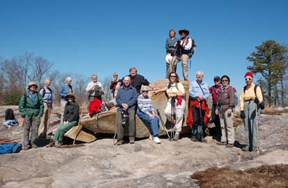
KagleStone Ramble 8:00 AM*
(strenuous)
Hike 10.4, Drive 80, 2100 ft. ascent, Rated A-AA
Tom Bindrim & Joan Lemire, 828-273-3880
*Meet at Westgate at 8:00 AM to form carpools, and meet leaders at Pisgah Forest Bi-Lo side parking lot at 8:40 AM. This will be a moderately-paced hike (expect late return.), in a Figure 8 that will take us to the tops of two more granitic bubbles that together with their more famous companions, comprise our local pluton. Some off-trail hiking, even bushwhacking. Topos Shining Rock and Rosman; Nat’l. Geo. PRD trail map is marginally useful.
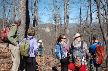 
The group started to form a little before 8:40, the second meet time, at the Pisgah Forest Bi- Lo, and by 8:45 or 8:50 there were 15 of us. It looked like we were going to have a good-sized crowd - the payback for when we got thoroughly rained out when the same hike was scheduled as a Wed hike on Feb 6. Only one thing though: 8:55 and "the Asheville hikers" hadn't arrived yet! And by around nine when some of the fifteen were starting to get antsy, it was looking like we'd been stood up by the Asheville folks, Ashok showed up to start marshalling his group, and one of the fifteen remembered he'd come by Westgate around eight & there was no one there, we took off for what turned out to be a flawless great hike enjoyed by everyone anyway.
The weather couldn't have been better. We were treated to some beautiful perspectives of Cedar Rock Mt. from the lunchspot at the end of Kagle Mt. Road and the tops of Kagle & Stone Mts. that are rarely seen by CMC hikers. We were reminded of Alan Barton's words "It may get this good, but it don't get no better!" Tom & Joan. Photos by Ted Connors.
ALL DAY NO. A0801-595 March 2
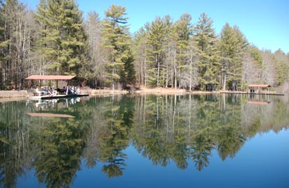
DuPont 3 Waterfalls and 3 Lakes 8:30 AM*
(moderate)
Hike 9, Drive 86, 1200 ft. ascent, Rated A-B
Ashok Kudva, 828-698-7119, ashok.kudva@mchsi.com
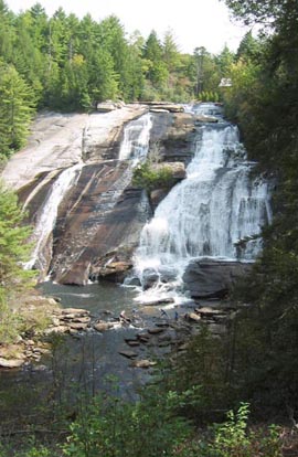
*Meet at Westgate at 8:30 AM to form carpools, and meet leader at Pisgah Forest Bi-Lo, side parking lot, at 9:00 AM. Between the Lake Imaging and Buck Forest parking lots we will visit Grassy Creek Falls, High Falls, Triple Falls, Lake Imaging, Lake Dense and Lake Alford. The last two lakes are named for local executives in the DuPont Company's Imaging Systems Manufacturing Department. After an optional half-mile bushwhack to the summit of Joanna Mountain, we will stop for lunch on picnic benches at Lake Dense with a backdrop view of Joanna Mountain. Short car shuttle. Topo: Standingstone Mtn.; also DuPont Forest Trail map, 6/7/05 revision
Seventeen hikers, including two first-timers who contacted us via the internet, joined in this newly designed hike on a warm winter day in the central DuPont State Forest. This land, deeded to the Thomas family in the 1790s as a land grant for contribution in the Revolutionary War, went through several splits and ownership changes ending in the current State Forest system described in http://www.blueridgenow.com/article/20070408/NEWS/704080303. Between 1955 and 2000, this region experienced the growth and decline of a U.S. manufacturing industry. For a history of Dupont company’s manufacturing site here and the DuPont State Forest go to: http://www.dupontforest.com/history.asp
The DuPont State Forest map lists the hundred trails with several intersections. I joined the illustrious group of CMC hike leaders who took the wrong trail at an intersection! As a result, we opted out of the optional bushwhack to the summit of Joanna Mountain. But, we completed the rest of the hike per plan.
On a pleasant sunny winter day, we enjoyed our lunch at scenic Lake Dense (named for Jack Dense who managed the DuPont plant in the 1970s) with a backdrop of Joanna Mountain. This area was forbidden for use by the employees, but was used to entertain visiting customers. We paused at the edge of Lake Julia, named for the wife of the owner of the old Summit Camp for Boys and Girls. DuPont Company bought the camp site in the 1980s. The other end of Lake Julia houses the forest ranger’s office. We watched High Falls and Triple Falls from the top and bottom. We took a snack break at the High Falls observation picnic shelter. Next to the shelter a chimney is still left intact from Buck Forest Lodge, a hunting, fishing and recreation club built in 1940. This two story lodge, demolished in 1957 when DuPont bought the land, was used by many Asheville professionals. Many hikers enjoyed soaking their feet at the bottom of both waterfalls.
Photos from this hike done on 3/2/2008 and 3/5/2008 can be accessed in the Member Albums of CMC website: http://outdoors.webshots.com/album/562710806VvHMYA. Ashok. Photos by Danny Bernstein.
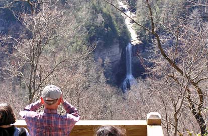
ALL DAY NO. A0801-330 March 9
Raven Cliff Falls 9:00 AM*
Hike 8, Drive 95, 1450 ft. ascent, Rated B-B
Kathy Kyle-Cornn, 828-698-3672, knkyle@yahoo.com
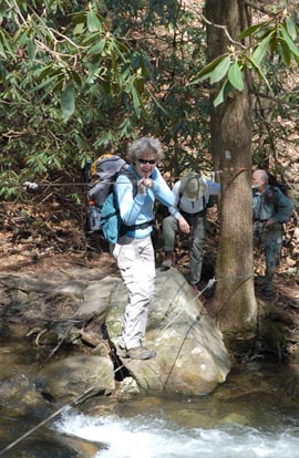
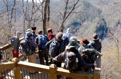
*Note later start time and that this is the first day of Daylight Savings Time; meet at Westgate at 9:00 AM to form carpools, and meet leader at Bi-Lo in Pisgah Forest at 9:30 AM. We’ll do a pleasant walk to the pedestrian bridge over the top of a beautiful 250 ft. waterfall in Caesar’s Head St. Park in S.C. The hike will follow the Raven Cliff Falls Trail and a portion of the Foothills Trail to the bridge, and then return with a side trip to the spectacular overlook of the falls and Matthew Creek Gorge. Topo: Table Rock; also Mountain Bridge Wilderness Area trail map
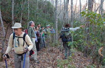
As a first time hike leader I was a novice Sunday, March 9. Before I get to the lessons I learned I'll summarize the hike. There were about 10 of us, and it was 10 minutes past meeting time at Bi-Lo, the secondary meeting place. We decided that there were no people coming from Westgate, the primary meeting place. Just as we got to our cars to leave, two cars from Westgate arrived.
There had been some confusion as to which Bi-Lo to meet. I quickly told them we were going to Caesars Head to use the bathroom there, and walk to the overlook before we started the Raven Cliff Falls hike. Everyone signed in hurriedly, and we were on our way. At least I thought so.
At the trailhead we realized two people were missing. One had not signed in so we really were just missing one. We started out with 19 people. Before beginning the trail I explained, as I did at Bi-Lo, that there was a slight change of the route for the middle of the hike.
During the scout of the hike we thought this was a loop hike down Dismal Trail, and it didn’t seem too hard to us. Although the distance was not that much more, the elevation gain was more than the hike description listed. Before we started there was a brief mention of splitting the large group into smaller groups with one group taking the flatter path to the falls. That idea somehow got dropped. We made it to the creek where we met with our first challenge, walking on a trapeze-like wire bridge over flooded Matthew ‘s Creek.
Then we ambled up the trail toward Raven Cliff Falls where our next obstacle was a small icicle avalanche. Then we skated across an iced narrow path at the base of the raven cliffs. No ravens were seen.
We did make it to the bridge and the top of the highest waterfalls in South Carolina, and ate a late lunch. We made it back to the parking lot at around 5, and we discovered the missing hikers’ car . We later learned they had headed toward Hendersonville by mistake, but had eventually followed our same hiking route.
So the lessons. Consider sticking to the original route, have directions prepared for each driver to the trail head, have lunch earlier than later, and be glad we have a group of resourceful and flexible hikers in the club. If that doesn’t work, reward yourself for making it through the hike with a dinner out like several people did on Sunday. Kathy. Photos by Ted Connors.
Half Day Sunday
HALF-DAY NO. H0801-168 March 2
Pink Beds 1:00 PM*
Hike 5, Drive 80, 200 ft. ascent, Rated C-C
Nonmembers, call leader, Lucy Prim, 828-693-6580, lucette32@mchsi.com
P400 *Note early start time. Meet at Westgate to form carpools, and meet hike leader at Pisgah Ranger Station at 1:35 PM. This is an easy loop hike with little elevation change, off US 276, not far from the Cradle of Forestry.
No report!
HALF-DAY No. H0801-064 March 9
Fletcher Creek via Spencer Branch Trail 1:00 PM*
Hike 6, Drive 50, Rated B-C
Nonmembers, please call leader, Greg Goodman, 828-684-9703
P400 *Meet at Westgate at 1:00 PM to form carpools, and meet leader at pull-out just before Mills River Recreation Area at 1:30 PM. From the Trace Ridge Trailhead, we will hike in a moderate loop along the Big Creek Trail, past the Hendersonville Reservoir, and along the Spencer Branch, Middle Fork and Fletcher Creek Trails. There will be a few stream crossings. Wednesday
WEDNESDAY NO W0801-595 Mar. 5
DuPont 3 Waterfalls and 3 Lakes 8:30 AM*
Hike 9, Drive 86, 1140 ft. ascent, Rated A-B
Ashok Kudva, 828-698-7119, ashok.kudva@mchsi.com
*Meet at Westgate at 8:30 AM to form carpools, and meet leader at Pisgah Forest Bi-Lo side parking lot at 9:05 AM. Between the Lake Imaging and Buck Forest parking lots we will visit Grassy Creek Falls, High Falls, Triple Falls, Lake Imaging, Lake Dense and Lake Alford. The last two lakes are named for local executives in the DuPont Company's Imaging Systems Manufacturing Department. After an optional 0.6 mile bushwhack to the summit of Joanna Mountain, we will stop for lunch on picnic benches at Lake Dense with a backdrop view of Joanna Mountain. Short car shuttle. Topo: Standingstone Mtn.; also DuPont State Forest Map, June 7, 2005 revision
Max and Florence Ballard, Spartanburg, SC, who joined CMC in 1976 but not hiked with us for 15 years, long time CMCers Lewis and Jane Blodgett and Rusty Breeding were among the 18 hikers who came on this hike on a sunny warm winter day. The waterfalls had a lot more gushing water, thanks to the heavy rain from the thunderstorm 24 hours ago, than during the same hike we did three days earlier.
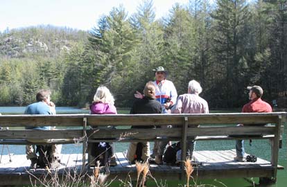
Eight hikers led by Adrian opted not to bushwhack to Joanna Mountain. They enjoyed 45 minutes of mountain scenes and pleasant sunshine while resting on boulders. Seven ladies and three men bushwhacked to the peak of Joanna Mountain. From the summit we descended to a rock face from where we saw a huge flat “phantom area” in the valley without any buildings. I shared with the hikers an archive DuPont Company publication with a photograph of buildings and hundreds of cars in the parking lot in that area. At the peak of the business, 1200 people (including me) worked in this manufacturing and R&D site. It was shut down in 2002: a bittersweet personal memory of 3 decades.
As in Sunday’s hike we had lunch at Lake Dense, walked to Lake Alford (named for Norman Alford, a former Assistant Plant Manager for DuPont) and Lake Julia. Oohs and aahs at the top and bottom of Grassy Creek Falls, High Falls and Triple Falls also matched Sunday’s hike.
Five hikers from Hendersonville and South Asheville area enjoyed a post-hike supper at Ruby Tuesday near the Asheville Airport. Photos from this hike and an image of the old multi-million dollar Dupont facilities in the current “phantom valley” are accessible in the Member Album section of the CMC website: http://outdoors.webshots.com/album/562710806VvHMYA. Ashok Photos by Ted Connors.
WEDNESDAY NO W0801-330 Mar. 12
Raven Cliff Falls 8:30 AM
Hike 8, Drive 95, 1450 ft. ascent, Rated B-B
Ruth Hartzler, 828-251-0886, ruthmtn@charter.net
We’ll do a pleasant walk to the pedestrian bridge over the top of a beautiful 250 ft. waterfall
in Caesar’s Head St. Park in S.C. The hike will follow the Raven Cliff Falls Trail
and a portion of the Foothills Trail to the bridge, and then return with a side trip to the spectacular overlook of the falls
and Matthew Creek Gorge. Second Meeting Place: Pisgah Forest Bi-Lo side parking lot at 9:05 AM.
Topo: Table Rock; also Mountain Bridge Wilderness Area trail map
 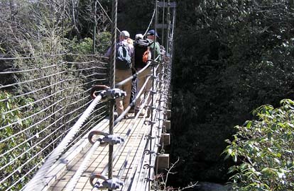
Twenty one hikers took advantage of the spectacular weather to hike in Caesar’s State Park in South Carolina. Under a sunny Carolina Blue sky, we hiked the Raven Cliff Falls, Gum Gap and Natureland Trust Trails down to the bridge over Raven Cliff Falls. The latter two trails had been freshly and generously blazed in iridescent blue and putrid peach. The blazing clearly had not been done by our more subtle CMC maintainers. As we stood on the bridge, water roared under us and crashed down the falls. One hiker commented that the sounds of the churning and crashing water surpassed the views.
After lunch, we journeyed back to the Raven Cliff Falls Trail to the observation deck. We could clearly see across the gorge to the bridge over the falls and the spot we had enjoyed an hour or two earlier. One new hiker was touring the area to find a place to raise a family. He managed to get to know each of us during the hike. The sounds of laughter and convivial conversation continued back to the trail head, a sign that we had fun. -- Ruth. Photos by Rusty Breeding.
All-day hikes submitted by Bruce Bente 692-0116, bbente@bellsouth.net . Driving distance is round-trip from Asheville. All Saturday and Sunday hikes assemble at Westgate Shopping Center near I-240 UNLESS OTHERWISE NOTED.
Half Day hikes submitted by Paula Robbins 828-687-1651 paularww@bellsouth.net and Lucy Prim 828-693-6580 lucette32@mchsi.com.
Wednesday Hikes are submitted by Charlie Ferguson, 828-398-0213 ccf108@gmail.com and Ann Gleason, 828-859-9387,
gleason.ann@gmail.com .
The meeting place for each hike will be designated by the hike leader and will appear in the hike description.
Driving mileage will be listed, round trip, from the first designated meeting place.
Leaders: Please mail your sign-up sheets. Meet at Westgate unless otherwise noted. |
 CMC Bi-Weekly Hike News