|
Looking Ahead
All Day Saturday & Sunday
ALL DAY NO. A0802-201 Apr. 13
MST: NC 80 over Woods Mtn. to Woodland Park 8:00 AM
Hike 12.2, Drive 85, 2600 ft. ascent, Rated A-AA
Don Walton, 828-654-9904, donwalton@bellsouth.net
This new CMC hike will hike a little-traveled and scenic section of the MST over Woods Mtn. and on to US 221,with seldom-seen views of the Blacks and Mt. Mitchell. Long descent. Car shuttle. Second meeting place: Little Siena Restaurant at intersection of US 70 and NC 80 at 8:30 AM. Topos: Celo, Little Switzerland
ALL DAY NO. A802-164 Apr. 20
Hawkbill Creek - Snowball Circuit 8:30 AM*
Carroll Koepplinger, 828-667-0723. carrollkoepp@bellsouth.net
Hike 8.4, drive 50, 2800 ft. ascent, Rated B-AA
*Note later start time. This great wildflower hike will begin alongside Hawkbill Creek, then climb a short but strenuous bushwhack up to Hawkbill Rock and Little Snowball Mtn., the site of an old fire tower, and then down to the starting point. The wildflowers and ramps have been spectacular every time CMC has taken this hike. The hike will also feature panoramic views from Hawkbill Rock and Little Snowball and enjoyable open-woods, off-trail hiking. The pace will be moderate. Topo: Craggy Pinnacle
Half Day Sunday
HALF-DAY No. H0802-171 Apr. 13
Cat Gap Loop *1:30 PM
Hike 5, Drive 40, 1100 ft. ascent, Rated C-B
Nonmembers, call leader, Lucy Prim, 828-693-6580, lucette32@mchsi.com
P400 *Meet at Westgate at 1:30 PM to form carpools, and meet leader at Fish Hatchery parking lot at 2:10 PM. This is a moderate loop hike on the Cat Gap Loop Trail.
HALF-DAY No. H0802-511 Apr. 20
Florence Nature Preserve 1:30 PM
Hike 5, Drive 40, 600 ft. ascent, Rated C-C
Nonmembers, call leader, Don Walton, 828-654-9904, donwalton@bellsouth.net
Tour the 600+-acre Florence Nature Preserve that may become part of a larger plan to establish a new NC State Park in the Lake Lure area. This is an easy loop hike through lady slippers and other spring flowers. Second meeting place: Parking lot adjacent to Nita’s Grocery in Gerton, near the preserve, at 2:00 PM.
All Day Wednesday
WEDNESDAY NO. W0802-104 Apr. 16
Wolfe Ford, High Falls & Rigby Cutoff 9:00 AM
Hike 7.3, Drive 60, 900 ft. ascent, Rated A-C
Charlie Ferguson, 828-333-5165, ccf108@gmail.com
P400 From the gauging station on the South Mills River, we'll hike this mostly level trail to High Falls, then cross the footbridge at Wolfe Ford. We'll take the Rigby Cutoff (named for CMC hiker Ed Rigby) near Squirrel Gap to return to the trailhead. Two small stream crossings. Second Meeting Place: Pisgah Ranger Station at 9:35 AM. Topo: Pisgah Forest; also Nat'l. Geo. PRD map #780
WEDNESDAY NO. W0802-033 April 23
Ramsey Cascades 8:30 AM
Hike 8, Drive 165, 2100 ft. ascent, Rated B-AA
Ashok Kudva, 828-698-7119, ashok.kudva@mchsi.com
900M The drive and effort are a small price to pay for the reward of one of the classic hikes in the Smokies.
We will pass through a grove of old-growth tulip poplars on our way to sixty-foot high Ramsey Cascades,
located in a rich forest. Showy Orchis, Dutchman’s Breeches, Trillium and other wildflowers will be in bloom.
Optional post hike dinner, probably at Bear Creek Grille.
Second meeting place: Pilot Truck Stop at exit 24 off I-40 at 9:00AM, but call the leader first.
Topo: Mt. Guyot; also Nat’l. Geo. GSMNP map #229
Looking Back......
All Day Saturday & Sunday
SATURDAY NO. A0801-423 Mar. 29
Pilot Rock, Laurel Mtn., Slate Rock Creek Trails 8:00 AM
Hike 10, Drive 90, 1600 ft. ascent, Rated A-A
Les and Catherine Love, 828-658-1489, lesrlove@charter.net
P400 We will hike up the Pilot Rock Trail, stopping to enjoy the views. Then we’ll turn downhill on the Laurel Mtn. Trail and a no-name trail to the Slate Rock Creek Trail, one of the gems of Pisgah Nat’l. Forest. Short car shuttle. Second meeting place: North Mills River Recreation Area parking lot at 8:30 AM, but call leader beforehand. Topo: Dunsmore Mtn.; also Nat’l. Geo. PRD map
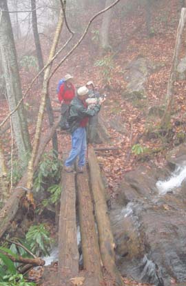 With the thunder storms and rain in the Asheville area only one person showed up for this hike at Westgate. Filling in for Les & Catherine Love as hike leader it seemed obvious that the rain was going to continue based on the forecast that morning. I decided to cancel the hike. As there was a second meeting place at the parking lot at the North Mills River camp ground I drove there thinking that no one would be there (but you never know) due to the rain. With the thunder storms and rain in the Asheville area only one person showed up for this hike at Westgate. Filling in for Les & Catherine Love as hike leader it seemed obvious that the rain was going to continue based on the forecast that morning. I decided to cancel the hike. As there was a second meeting place at the parking lot at the North Mills River camp ground I drove there thinking that no one would be there (but you never know) due to the rain.
Low and behold there were three determined hikers including one first time hiker with CMC. Welcome Peter. These three hikers weren’t about to abort the hike. So, at 9:10 am the four of us left the Pilot Rock trail head in what was not to promising weather. Within a half hour we donned rain gear. With some light rain along with a few drops of sleet at one point and with dense fog and temps in the upper 40’s and into the low 50’s we set a good steady pace up Pilot Rock the Laurel Mtn. trail and down the no name trail to hook up with the beautiful Slate Rock trail. Slate Rock Creek is very dynamic and beautiful.
Of course we took extra effort to verify to the newcomer all the beautiful vistas that were hiding in the dense fog. This hike is a 7.2 mile hike with approximately a total 1,450 ft.ascent of which most of the climbing is on the first couple of miles. Along with a short lunch and a steady pace we returned to the car at 1:10 pm. Carroll. Photo by Carroll.
#780ALL DAY NO. A0801-597 March 30
Heartbreak Ridge – Rocky Mtn. Loop 8:00 AM
Hike 13, Drive 70, 4600 ft. ascent, Rated AA-AA+
Stuart Tauber and Joanne Tulip, 828-254-0824, sdtauber@charter.net
This very strenuous hike will be limited to ten hikers, and hikers are required to contact the leader beforehand. The hike will start at Graphite, climbs to and up Heartbreak Ridge past Glass Rock Knob to the summit of Rocky Mtn. A spectacular view of nearby mountains appears here. From the ridgeline, hikers must be mentally and physically prepared for a dramatically steep and risky descent (1000 ft. in 1/3 mile) to Jarrett Creek Rd. near Star Gap. From here, the hike will follow the road to Heartbreak Ridge and retrace the route back to the trailhead. Second meeting place: parking lot adjacent to McDonalds at exit 64 of I-40 at 8:20 AM Topos: Old Fort, Montreat
Rescheduled because of the weather
ALL DAY NO. A0802-031 Apr. 6
South Mtns. Loop 8:00 AM
(strenuous)
Hike 9.3, Drive 170, 2350 ft. ascent, Rated A-AA
Danny Bernstein, 828-236-0192, danny@hikertohiker.com
South Mountains State Park south of Morganton has outstanding views, a beautiful waterfall, and a new visitor center. We’ll climb to Jacob Fork River Gorge Overlook and then continue to Chestnut Knob Overlook, a rocky outcropping with outstanding views toward the Kings Mountain Range and on a clear day, Charlotte’s skyline. Later after another climb, we’ll reach the top of High Shoals Waterfall – truly awesome. Awesome too is the wooden staircase and platform, which allows a close look at the falls and the jumble of rocks in Jacob Fork. Since this is a state park, the trails are meticulously maintained. Optional supper after the hike in Black Mountain. Second meeting place: Parking lot adjacent to McDonald’s at exit 64 of I-40 at 8:20 AM. Topo: Benn Knob
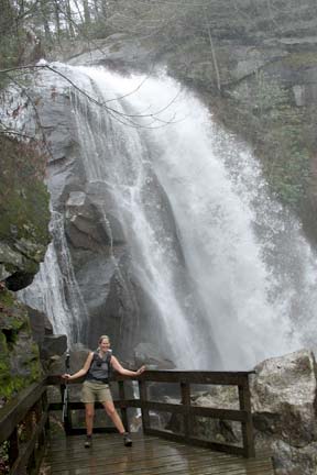 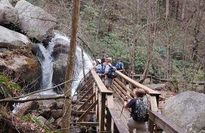
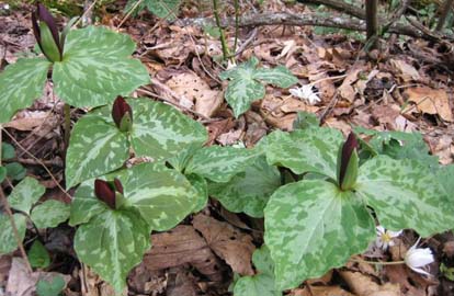
South Mountain State Park attracted 12 hikers, four of them not in our immediate area. We met hikers from Charlotte, Statesville and Greenville, SC. The hike took us to two views, the first across the valley to a waterfall and the second to a rock where, with a little imagination and binoculars, we could see Charlotte. Then down, down, down where we crossed Jacob Creek without a bridge. We just plunged in and got our boots and socks wet. This was my fourth time crossing that creek and the first time, I got wet.
We climbed up again to High Shoal Falls which sprayed and spittted at us. We saw wake robin trillium, hepatica and several varieties of violets.From the top of the waterfall, we took an amazing wooden staircase down. This is what tourists climb to see the waterfalls. After the hike, we watched a movie at the new visitor center. If you thought that state parks were wimpy, this park and several others I've explored may change your mind. Danny. Photos by Danny Bernstein, left and Ted Connors, right.
ALL DAY NO. A0802-604 Apr. 6
Splash Dam via Trace Ridge *8:30 AM
(moderate)
Hike 7.8, Drive 42, 1100 ft. ascent, Rated B-B
Dave Wetmore, 828-884-7296, dwetmore@citcom.net
P400 *Note later start time. Meet at Westgate at 8:30 AM to form carpools, and meet leader at Trace Ridge Trailhead at 9:00 AM. This will be a moderate hike mostly on old roadbeds up the Big Creek Trail, to what appears to the uninitiated as only a rocky place. If those rocks could talk, they would tell a tale of long arduous months of labor, the pitfalls of succession, the striving of man with nature and the consequences of that effort. Several wet but easy stream crossings. Come and learn the secrets of Big Creek! Topo: Dunsmore Mtn.; also Nat’l. Geo. PRD map #780
After 4 days of rain and looking closely at Mills River, the hike leader decided that fording Big Creek several times was not a good idea. The hike was cancelled, and will be rescheduled for the third quarter. Dave.
Half Day Sunday
HALF-DAY NO. H0801-319 March 30
Holmes Educational Forest 1:00 PM*
Hike 5, Drive 75, 500-ft. ascent, Rated C-C
Nonmembers, call leader, Rusty Breeding, 828-692-0359, bree_lw@planetusa.net
*Note early start time. Meet at Westgate at 1:00 PM to form carpools, and meet leader at the Pisgah Forest Bi-Lo side parking lot at 1:30 PM. A good early spring hike with "talking trees" and a Forest Demonstration Trail explaining good forestry practices as well as some early wildflowers
The sky was a solid overcast, 70% chance of
precipitation; temperature 40º F.
Seven hikers shugged that off; said, "Let's Go!"
We circled the three low-level loop trails where
anyone can take their non-hiking visitors or
grandchildren. We saw a Forest Service helicopter, old
Spivey Mountain fire tower (just the top), talking
trees, lots of Trout Lilies and several Blood Roots
just waiting for the sun to open their blooms. We
picked up a pamphlet at the beginning of the
Demonstration Trail and climbed the mountain.
Thirteen points of interest are listed: Selected
Harvest areas, Pond with Wood Duck houses, Pulpwood
Cord Demonstration, etc. Mystery bird: While the
leader had her back turned, a huge bird was seen by
everybody else. It was described as a Canada Goose,
but had flown from a tall pine tree. Do geese perch
in trees??? We checked out the primitive campground
and descended by the Wildcat Rock Trail which Harlow
Hoskins' Carolina Mountain Club maintenance team built
many years ago. Rusty.
HALF-DAY No. H0801-344 April 6
Pulliam Creek in the Green River Game Lands 12:30 PM*
Hike 6.5, Drive 60, 1000 ft ascent., Rated B-B
Nonmembers, call leader, Becky Elston, 828-749-1886, belston@cytechusa.com
*Note early start time. Meet at Westgate at 12:30 PM to form carpools and meet hike leader at NW corner of parking lot of Cracker Barrel off Exit 53 of I-26 at 1:00 PM. This pretty in-and-out hike goes along Pulliam Creek for part of the way, and our break might include viewing kayakers on the Green River and seeing trillium and other early spring wildflowers. Join leader for dinner at Cracker Barrel after the hike.
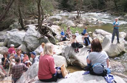 
Turned out to be a great day for a hike after our 3 days of rain. 22 braved the relatively high water down to the Green River.
Saw thousands of trilliums. In the future this should be titled the "Trillium Hike." Becky. Photos by Chris Allen.
All Day Wednesday
WEDNESDAY NO W0801-439 Apr. 2
Pounding Mill Loop 8:00 AM*
Hike 8, Drive 55, 950 ft. ascent, Rated B-C
Greg Goodman, 828-684-9703
*Meet at Westgate at 8:00 AM to form carpools, and meet leader at Boyleston Baptist Church on NC 280 at 8:30 AM. This hike takes the South Mills River Trail to the Pounding Mill Trail and on to Squirrel Gap Trail. We’ll continue onto Pea Gap and then return on the Bradley Creek Trail. Topo: Pisgah Forest; also, Nat’l. Geo. PRD map #780
WEDNESDAY NO. W0802-200 April 9
Jones Gap State Park – Middle Saluda River *8:30 AM
Hike 9, Drive 96, 1200 ft. ascent, Rated B-B
Becky Elston, 828-749-1886, belston@cytechusa.com
*Meet at Westgate at 8:30 AM to form car pools, and meet hike leader at NE corner of Cracker Barrel
parking lot at Exit 53 of I-26 at 9:00 AM. An in-out hike. Follows the Jones Gap trail (part of the Foothills Trail)
along the Middle Saluda River most of the way with lunch at a nice double waterfall.
Elevation change is a very gradual 1200 feet. Remember SC Jones Gap State Park is a fee area with $2 per person for hiking.
Topo: Standingstone Mtn.; also Mountain Bridge Wilderness trail map
Had 15 hikers on a beautiful day in Jones Gap State Park in South Carolina. It was billed as a 9 mile hike but we wanted to vear off for about a mile to show Barth some new bridges (yeh right!) and ended up doing 10 miles. All was forgiven and we had a great hike with 3 beautiful waterfalls. Most of the hike follows along the Middle Saluda River which was raging due to the recent rains. Becky
All-day hikes submitted by Bruce Bente 692-0116, bbente@bellsouth.net . Driving distance is round-trip from Asheville. All Saturday and Sunday hikes assemble at Westgate Shopping Center near I-240 UNLESS OTHERWISE NOTED.
Half Day hikes submitted by Paula Robbins 828-687-1651 paularww@bellsouth.net and Lucy Prim 828-693-6580 lucette32@mchsi.com. Wednesday Hikes are submitted by Charlie Ferguson, 828-398-0213 ccf108@gmail.com and Ann Gleason, 828-859-9387,
gleason.ann@gmail.com .
The meeting place for each hike will be designated by the hike leader and will appear in the hike description.
Driving mileage will be listed, round trip, from the first designated meeting place.
Leaders: Mail please mail your sign-up sheets. Meet at Westgate unless otherwise noted. |
 CMC Bi-Weekly Hike News