All Day Saturday & Sunday
SATURDAY NO. A0902-643 May 16
Woods Mtn. Natural History hike *9:00 AM (note time change from Let's Go).
Hike 6, Drive 80, 1400 ft. ascent, Rated B-B
William Grow, 828-756-4070, waxwing4@verizon.net
Theme hike *Note later start time. Meet at Westgate at 10:00 AM to form carpools, and meet leader at the McDonald’s at Exit 73 (Old Fort) at 10:30 AM. Starting at the Woodlawn USFS Work Center on US 221 north of Marion, we will hike on the MST going west. We first will go along an old logging road but soon the trail turns off and slants down to Tom's Creek and then starts up toward the summit of Wood's Mountain along Betsy's Ridge. We will go part way up and then return by the same route. Since this is a natural history hike, how far we get depends upon how many wildflowers/birds/whatever we stop to look at. Anyone having them should bring magnifying glasses and/or binoculars. The number of hikers is limited to 15. Please contact the leader to reserve your space. Topos: Marion West, Little Switzerland
ALL DAY NO. A0902-372 May 17
Big Fork Ridge–Rough Fork loop *8:30 AM
Hike 9.3, Drive 95, 1800 ft. ascent, Rated A-A
Danny Bernstein, 828-236-0192, danny@hikertohiker.com
900M, Smokies 75th Anniversary hike. Cataloochee was one of the most successful communities in the Smokies. From the end of the Cataloochee Valley, we’ll hike up Big Fork Ridge Trail, then turn right onto Caldwell Fork Trail. We’ll pass by record-size tulip poplar trees, then go downhill on Rough Fork Trail. About a mile from the end of the hike, we’ll stop at the Woody House, a well-appointed framed house. On the way out of the valley, we’ll stop at the Palmer Chapel Cemetery. Second meeting place: Pilot Truck Stop, Exit 24 off I-40 at 9:00 AM. Topo: Dellwood; also Nat’l. Geo. GSMNP map #229
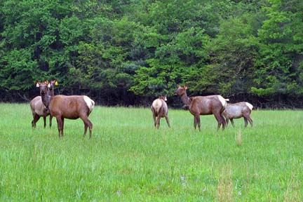 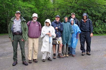
Photos by Danny Bernstein
It was forecast as a miserably wet day and the forecasters were correct. Yet, 11 of us, including a newcomer, sloshed through the mud and muck and enjoyed the day tremendously. This Cataloochee hike was the second in a series that CMC is doing to celebrate the 75th anniversary of the Smokies. We had several distinguished guests as a result. Kevin Fitzgerald, Deputy Superintendent of the Great Smoky Mountains National Park, hiked with us. He’s the fellow in the blue cap and blue jacket, fourth from the left. Justin Spinks, a photojournalist intern from UNC-Chapel Hill, was sent from the Charlotte-Observer to photograph the hike. The Charlotte-Observer is doing a series of articles on the 75th. Justin was busy photographing and is not in the picture. Mary Ellen Hammond and Jim Parham of Milestone Press came with their son, Sydney. Also, Mark LaShell, (shown on the left) a ranger in Cataloochee, greeted us in the rain at the trailhead. Mark begged off the hike since he had lots of paperwork. Last but maybe most important, the elk greeted us. They were out in the rain in the large field in the valley as we came in: the boys on one side of the field, the girls on the other side.
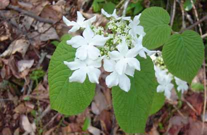
Even in the constant rain, we stopped for flowers including showy orchis and Vasey’s Trillium. When we passed the elk pen, Kevin recapped the elk project. At lunch, he talked about what the park is doing about the Hemlock Wooly Adelgid. I think I’ll try to make Kevin’s visit on one of my Smokies hikes, an annual event. -- Danny Bernstein
ALL DAY NO. A0902-547 May 24
MST west from Balsam Gap *9:00 AM
Hike 7, Drive 80, 1600 ft. ascent, Rated B-A
Stu English, 828-883-2447, stuengo@citcom.net
*Note later start time. Come to see the MST extension that CMC has been building for the last 6 years. We did a similar hike 2 years ago, but six subsequent CMC work days have extended the new trail farther uphill. We will hike the MST from Balsam Gap to the end of trail and perhaps a little farther. Car shuttle. Second meeting place: Rest area beyond Waynesville on US 23/74 at 9:30 AM. Topo: Hazelwood
On a rainy Sunday, I didn’t expect to see anyone at Westgate. But there was Carroll, just back from France and wanting to hike. Since I was obligated to go to the rest area on 23/74, we agreed to go to the end of the new MST at Scott Creek Overlook and go back, seeing the new MST, and then retrace out steps. Officially the hike was cancelled. Carroll and I did our own hike. I drove back to Brevard by the parkway in alternating sun, fog, clouds, and rain. It was all good.--Stu English
MEMORIAL DAY NO. A0902-095 / 257 May 25
Hike 9.5 or 13.7, Drive 95, 1900 or 3200 ft. ascent, Rated A-A or AA-AA+ *8:30 AM
Becky Smucker, 828-298-5013, bjsmucker@gmail.com
900M *Note later start time. Our annual joint hike with the Smoky Mountains Hiking Club again offers options for hikes of different distances and difficulties. We will hike from Polls Gap to our scenic lunch spot at Hemphill Bald in the GSMNP. The return route will either be by returning via the same trail, or by a longer hike down to the Caldwell Fork trail, passing old-growth tulip trees and returning to Polls Gap on the Rough Fork Trail. Second meeting place: Maggie Valley Post Office, rear of parking lot, at 9:00 AM, but contact leader first. Topos: Dellwood, Bunches Bald; also Nat’l. Geo. GSMNP map #229
--Back to Top
Half Day Sunday
HALF-DAY NO. H0902-640 May 17
Walker's Knob above Montreat *12:10 PM
Hike 5, Drive 40, 1800 ft. ascent, Rated C-A
Non-members, call leader, Renate Rikkers, 828-298-9988, rerikkers@aol.com
*Note early start time. Meet at Westgate at 12:10 PM to form carpools, and meet leader at Ingles parking lot adjacent to McDonald's in Black Mountain off Exit 64 of I-40 at 12:30 PM. Popular with Montreaters for generations, the hike to Walker's Knob is moderately difficult and very rewarding. Using the Greybeard Trail, we have a steady climb to reach Walker's Knob, a rock outcropping with spectacular views of Swannanoa River Valley and Mountains beyond. Not suggested for beginning hikers.
The hike to Walker's Knob today was canceled due to heavy rains. No one showed up at Westgate, just one person at Black Mtn.--Renate Rikkers
HALF-DAY NO. H0902-043 May 24
Frying Pan Tower *12:30 PM
Hike 4, Drive 50, 400 ft. ascent, Rated C-C
Nonmembers, call leader, Bobbi Powers, 828-667-5419, bobbip@netzero.net
P400, LTC *Note early start time. Meet at Westgate at 12:30 PM to form carpools, and meet leader at north end of parking area of Pisgah Inn at 1:00 PM.
This is an easy in and out hike through a spectacular display of wild flowers to good views from the tower.
After canceling the hike due to threatening weather, I drove to Pisgah Inn, the second meeting spot, where four intrepid hikers awaited in the drizzle. We did an abbreviated hike, the Frying Pan Trail portion, returning to the cars just as the rain whooshed down. A highlight was seeing a mature, fruit-bearing American Chestnut tree.--Bobbi Powers
--Back to Top
All Day Wednesday
WEDNESDAY NO. W0902-257 May 13
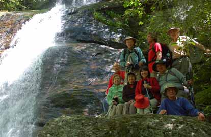
Hemphill Bald - Rough Fork Loop *8:00 AM
Hike 13.7, Drive 96, 3200 ft. ascent, Rated A-AA
Brenda Worley, 828-684-8656, clworley@bellsouth.net.
900M *Meet at Westgate at 8:00 AM (No second meeting place). Spectacular views at Hemphill Bald, good lunch spot in open meadow with stone table, record-size trees near junction of Hemphill Bald and Caldwell Fork Trails. We expect to see many spring wildflowers along the trail. The pace will be moderate. Topos: Bunches Bald, Dellwood; also Nat’l. Geo. GSMNP map #229
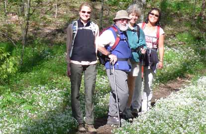 
Photos by Brenda Worley
Four showed up for this challenging hike. The weather was beautiful and the views and wildflowers were abundant. On the way,we stopped the car as a small herd of elk ambled by. Great day.--Brenda Worley
WEDNESDAY NO W0902-648 May 20
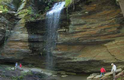
Seven Waterfalls in Pisgah Nat’l. Forest *8:00 AM
Hike 6, Drive 100, Rated C-C
Jack Fitzgerald, 828-685-2897, suejackfitz@bellsouth.net
WC100 *Meet at Westgate at 8:00 AM to form carpools, and meet leader at Pisgah Forest Ranger Station at 8:35 AM. Visit seven waterfalls in Pisgah Nat’l. Forest, all on the Waterfall 100 Challenge: Looking Glass, Moore Cove, Skinny Dip, Dill, Courthouse, Bird Rock and Cathey's Creek. All are in and out hikes of 2 miles or less for each waterfall.
Photos by Ted Connors
On a beautiful day 10 hikers visited 7 major waterfalls in the Pisgah Forest: Looking Glass, Moore Cove, Skinny Dip, Dill and Upper Dill, Courthouse, Birdrock and Cathey Creek. We added two bonus falls, Little Moore Cove and Mill Shoals. All of the falls were flowing at rates not seen in several years.--Jack Fitzgerald
WEDNESDAY NO. W0902-636 May 27
Coontree-Bennett Gap-Pressley Cove Lollipop *9:00 AM
Hike 8.4, Drive 75, 1900 ft. ascent, Rated B-A
Ashok Kudva, 828-698-7119, ashok.kudva@mchsi.com
P400 * Note later start time. Meet at Westgate at 9:00 AM to form carpools, and meet the leader at Pisgah Ranger Station at 9:35 AM. This hike is an extension of the popular half-day Coontree Loop hike. We start ascending the left branch of Coontree trail, proceed in and out on Bennett Gap and Pressley Cove trails and descend on the right branch of Coontree trail to the cars. We will visit an old homestead chimney, a remnant of the farming community between Pressley Cove and Maxwell Cove. Topo: Pisgah Forest; also Nat’l. Geo. PRD map #780
Reports for Wednesday hikes during the eNews publication week will appear in the following eNews--The Editor.
--Back to Top
All-day hikes submitted by Bruce Bente 692-0116, bbente@bellsouth.net . Driving distance is round-trip from Asheville. All Saturday and Sunday hikes assemble at Westgate Shopping Center near I-240 UNLESS OTHERWISE NOTED.
Half Day hikes submitted by Lucy Prim 828-693-6580 lucette32@mchsi.com.
Wednesday Hikes are submitted by Charlie Ferguson, 828-398-0213 ccf108@gmail.com and Ann Gleason, 828-859-9387,
gleason.ann@gmail.com .
The meeting place for each hike will be designated by the hike leader and will appear in the hike description.
Driving mileage will be listed, round trip, from the first designated meeting place.
Leaders: Mail please mail your sign-up sheets. Meet at Westgate unless otherwise noted.
|