SATURDAY No. A0602-513 May 20 Tree Identification hike (Craven Gap to Tanbark Tunnel) 9:00 AM* Hike 4.6, Drive 6, 900 ft. ascent, Rated C-C Dan Lazar, 828-280-5556, danlazar@bellsouth.net *Note later start time. This will be a theme hike dedicated to tree identification. We will hike the MST from Craven Gap to Rattlesnake Lodge and down to Tanbark Tunnel, on a slow-paced hike dedicated to field identification of trees along the route. We’ll stop occasionally to learn the natural history of the forest we’re hiking through. Short car shuttle. *Only meeting place will be at Craven Gap. Topo: Craggy Pinnacle; also MST Profiles book, pg. 62-63
ALL DAY No. A0602-329 May 21 Blackrock Mtn. via Fisher Creek Trail 8:00 AM Hike 7.4 or 10.8, Drive 96, 2900 ft. ascent, Rated B-AA or A-AA Dave Wetmore, 828-884-7296, dwetmore@citcom.net SB6K? This hike starts at the end of Fisher Creek Rd. east of Sylva and climbs to the summit of Blackrock Mtn. The trail, mostly old logging roads, is steep and rocky in places, but the views from Blackrock Mtn. are superb. Depending on the weather, we may go on to Yellowface (3.4 additional miles on ridgeline) and make this a SB6K hike. Optionally, we may climb to the Pinnacle instead, with the same trailhead but only 2100 feet of elevation gain. Second meeting place: Rest area on US 23/74 near Waynesville at 8:30 am. Topo: Sylva North
BACKPACK No. A0602-514 May 26 - 29
The route of the backpack has been changed and so has the leader.Please refer to www.hikertohiker.org/cmcbp06 for all details. Space is limited to eight hikers so please verify that you can attend before reserving a spot. Topos: Fontana Dam, Cades Cove, Thunderhead Mtn., Tuskeegee; also Nat’l. Geo. GSMNP map
ALL DAY No. A0602-336 May 28 Mt. Cammerer from Big Creek 8:00 AM Hike 11.8, Drive 110, 3300 ft. ascent, Rated A-AA+ Janet Martin, 812-738-8154, jaykaymartin@msn.com 900M This great hike from Big Creek to the historic fire lookout atop Mt. Cammerer goes up the Chestnut Branch Trail and AT. Strenuous, but the payoffs are first class: a good workout and superb views. Second meeting place: Pilot Truck Stop at exit 24 off I-40 at 8:30 AM. Topos: Waterville and Hartford; also Natl. Geographic GSMNP Map MEMORIAL DAY JOINT HIKE WITH SMOKY MTNS. HIKING CLUB
ALL DAY No. A0602-515 May 29 AT: Brown Gap to I-40 8:00 AM* Hike 10.6, Drive 100, 1700 ft. ascent, Rated A-A Joe Cirvello, 828-627-1797, cirvello25@bellsouth.net (CMC contact) Our annual joint hike with the Smoky Mtns. Hiking Club will follow the AT from Brown Gap to I-40, with a great view from Snowbird Mtn. and a long descent into the Pigeon River Gorge. Car shuttle. * Meet at Westgate at 8:00 AM to form carpools, and meet leader at 8:30 AM at Pilot Truck Stop at exit 24 off I-40. Topo: Waterville; also Nat’l. Geo. French Broad & Nolichucky Rivers map
SATURDAY (NATIONAL TRAILS DAY) NO. A0602-516 June 3 Lakeshore Loop 8:30 AM* Hike 8, Drive 145, 800 ft. ascent, Rated B-C Danny Bernstein, 828-236-0192, danny@hikertohiker.org 900M *Note later start time. Starting at the Lakeshore tunnel, we’ll do an easy loop, consisting of the Lakeshore, White Oak Branch and Forney Creek Trails. We’ll lunch at the Fontana Lake shoreline, and then return on the Lakeshore trail and back through the tunnel. We’ll be on the eastern end of the proposed North Shore Road where we’ll hike easy trails to see house sites, a creek and cemeteries. This is CMC’s contribution to National Trails Day. Experience your outdoors. Second meeting place: Rest area beyond Waynesville on US 23/74 at 9:00 AM Topo: Noland Creek; also Nat’l. Geo. GSMNP map
ALL DAY No. A0602-163 June 4 Linville Gorge, Sandy Flats to Pine Gap 8:00 AM Hike 7, Drive 130, 1500 ft. ascent, Rated B-A Don Walton, 828-654-9904, donwalton@bellsouth.net Strenuous hike! We’ll first descend 1300 ft. in less than a mile from Sandy Flats trailhead, then hike upstream along the Linville Gorge in the depths of the gorge. One of the great streams of WNC. Then out of the gorge via the Pine Gap Trail. Short car shuttle. Second meeting place: Parking lot adjacent to McDonald’s off I-40 at exit 64 at 8:20 AM. Topos: Ashford, Linville Falls; also Linville Gorge Wilderness map
HALF-DAY No. H0602-464 May 21Greybeard Overlook to Balsam Gap 1:00 PM*Hike 3.9, Drive 44, 700 ft. ascent, Rated C-CRuth Hartzler, 828-251-0886 ruthmtn@charter.net
*Note early start time, and only meeting place is Folk Art Center lower parking lot. Although the distance on this portion of the Mountains-to-Sea Trail is not long, this hike provides a good workout, with 700 ft. ascending and 900 ft. descending, with great views midway. Short car shuttle.
HALF-DAY No. H0602-153 May 28Caney Bottom –Cove Creek Loop 1:00 PMHike 4.6, Drive 40, 1280-foot ascent, Rated C-BRenate Rikkers, 828-298-9988, rerikkers@aol.com
P400 *Note early start time. This is a pleasant loop hike off FS 225. Second meeting place: Fish Hatchery on FS 475 at 1:35 PM.
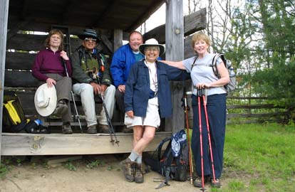
HALF-DAY No. H0602-512 June 4Pisgah Inn to Big Ridge Overlook 1:00 PM*Hike 5.7, Drive 40, 800-ft. ascent, Rated C-CKen and Carol Deal, 828-281-4530, KMCDeal@aol.com
P400 *Note early start time. Hike on the Mountains-to-Sea Trail from the Pisgah Inn, with a brief stop to view the Buck Spring Lodge site. We will continue over Little Pisgah Mountain down to the Big Ridge Overlook on the Blue Ridge Parkway. Car shuttle.
WEDNESDAY No. W0602-517 May 17
South Mills River Ramble 8:00 AM* Hike 11.5, Drive 70, 2500 ft. ascent, Rated A-AA Tom Bindrim and Joan Lemire, 828-273-3880 P400 A nice ramble at a moderate pace, including Funneltop, Cantrell Creek and the Rigby Cutoff. Some off-trail hiking. Bring extra food in case we get back later than expected. *Meet at Westgate at 8:00 AM to form carpools, and meet leaders at the Bi-Lo parking lot in Pisgah Forest at 8:30 AM. Topo: Pisgah Forest; also Nat’l. Geo. PRD map
WEDNESDAY No. W0602-163 May 24 Linville Gorge, Sandy Flats to Pine Gap 8:00 AM Hike 7, Drive 130, 1500 ft. ascent, Rated B-A Don Walton, 828-654-9904, donwalton@bellsouth.net Strenuous hike! We’ll first descend 1300 ft. in less than a mile from Sandy Flats trailhead, then hike upstream along the Linville Gorge in the depths of the gorge. One of the great streams of WNC. Then out of the gorge via the Pine Gap Trail. Short car shuttle. Second meeting place: Parking lot adjacent to McDonald’s off I-40 at exit 64 at 8:20 AM. Topos: Ashford, Linville Falls; also Linville Gorge Wilderness map
WEDNESDAY No. W0602-521 May 31 MST: Mt. Pisgah to Bent Creek Gap 8:30 AM Hike 9.4, Drive 45, 1900 ft. ascent, Rated B-A Becky Smucker, 828-298-5013, bsmucker@charter.net P400 Note later start time. We will start with a round trip up and down Mt. Pisgah, stopping to enjoy the view, and will then follow a beautiful section of the MST northbound to Bent Creek Gap. Expect good views along the route. Car shuttle. Second meeting place: BRP French Broad overlook at 8:40 AM. Topos: Cruso, Dunsmore Mtn.; also Nat’l. Geo. PRD map & MST Profiles, pg. 53-55
ALL DAY No. A0602-124 May 7
Clingman’s Dome and Mt. Collins 8:00 AM (strenuous) Hike 11.7, Drive 150, 1900 ft. ascent, Rated A-A Lenny Bernstein, 828-236-0192, lsberns@worldnet.att.net
SB6K, 900M Here’s a chance to knock off two of the SB6K peaks in the Smokies. We will hike the AT from the Fork Ridge access, over Mt. Collins (6188 ft.) and Clingman’s Dome (6643 ft.), enjoy the views and then return 8 miles to Newfound Gap. Those wishing a shorter hike can return to the original trailhead, for an 8-mile hike. Second meeting place: Quality Inn in Maggie Valley (US 19 side) at 8:30 AM. Topo: Clingman’s Dome
Hike was cancelled because of heavy rains. It has been rescheduled for July. Look for it in the third quarter schedule. Lenny
ALL DAY No. A0602-456 May 7
AT: Stecoah Gap to Yellow Creek Gap 8:10 AM (moderate) Hike 7.6, Drive 170, 1700 ft. ascent, Rated B-A Chip Miller, 828-654-9331, backpacker54nc@bellsouth.net
A moderate hike on a southern portion of the AT, between Stecoah Gap and Yellow Creek Gap. Guaranteed to see lots of wildflowers, including rare yellow trilliums and yellow ladyslippers.
There will be a car key swap. Second meeting place: Rest stop beyond Waynesville on US 23/74 at 8:40 AM. Topos: Hewitt, Fontana Dam
AT: Stecoah Gap to Yellow Creek Gap direction
Three hikers did the Stecoah Gap to Yellow Creek Gap direction of this key swap hike. We started the long uphill from Stecoah Gap and immediately were surrounded by a wealth of blooming wildflowers which continued for the rest of the hike. Everyone was amazed by the variety and abundance of the blooms, which included pink and yellow ladyslippers and yellow trilliums, among many other species. The weather was special...for most of the hike, we hiked in the clouds, with cool fog all around us, giving a restful and quiet feeling. We met the other group at a rock outcrop on a ridgeline and had a good lunchtime sharing our morning experiences on the hike.
After the hike, we met the other group to rearrange riders and were surprised to find 4 AT section hikers in the back of Chip's truck. Chip's report will explain this rescue effort. -reported by Bruce Bente
ALL DAY No. A0602-218 May 14
Cataloochee Divide 8:00 AM Hike 12, Drive 85, East Bound: 1800 ft. ascent, Rated AA-A, or West Bound: 2800 ft. ascent, rated AA-AA Bruce Bente, 828-692-0116, bbente@cytechusa.com and Marianne Newman, 828-454-1036, marianneln@msn.com
900M If it is clear, we will experience some of the most spectacular views in WNC as we hike over Hemphill Bald and the Swag. Wildflowers should be wonderfully abundant. Key swap hike, with half the group starting from each end. Second meeting place: back parking lot of Quality Inn in Maggie Valley at 8:30 AM, but call leader beforehand. Topos: Cove Creek Gap, Dellwood, Bunches Bald; also Nat’l. Geo. GSMNP map
Cataloochee Divide westerly direction
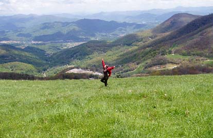
Seven hikers enjoyed the Cataloochee Divide hike in the westerly direction. As reported by Marianne for the easterly direction of this key swap, the weather was perfect for hiking, and an abundance of wildflowers were seen. We had a short lunch #1 at the Swag overlook, then proceeded up to Hemphill Bald for a longer lunch #2 and enjoyment of the scenery. Some hikers were very enthusiastic about the view from the bald--see the attached photo.
About 20 minutes before the end of the hike, we heard a loud snorting down the hill as we spooked a wild hog feeding below us. He/she decided to leave the area quickly and only a couple of hikers spotted the black beast. The area all around the trail at this point is rooted up from hogs feeding in this area.
After hiking, we stopped at Snappy's for supper, and were soon joined by the six hikers from the other half of the hike. A good meal was had by all
-reported by Bruce Bente
From the easternly direction.
A total of 13 hikers relished a cool and gorgeous day on Cataloochee Divide, seven taking the "uphill" route from Cove Creek to Polls Gap and six going "downhill" in the opposite direction. In fact, the main up/down difference is about a two-mile vertical stretch from just below The Swag to Hemphill Bald. Both groups lunched at Hemphill Bald and took breaks, for hors d'oeuvres or for dessert, at The Swag. The views from both these places, from spots on the trail itself, and from a small shelter at [whose? - help, Danny, I've forgotten the name] Turnaround definitely make the climb/descent worthwhile.
Each group identified 45 species of wildflowers, though we're not yet sure how closely our lists match up. Fringed phacelia still blanketed many of the hillsides, along with various trilliums, trout lilies, etc. The downhill group found extensive wild hog damage near the Polls Gap end of the trail.
This is a fantastic hike in any season, but the plants and views in spring and fall are truly outstanding. Marianne Newman.
HALF DAY No. H0602-403 May 7
Dupont Forest: Fawn Lake P.L. #5 12 Noon*Hike 6, Drive 90, Rated B-BBecky Elston, 828-749-1886, belston@cytechusa.com
*Note early start time. A moderate loop hike covering portions of six different trails and featuring Reasonover Creek. A new bridge over the creek eliminates the former “boots-off crossing.” Meet at Westgate at 12 noon to form carpools, and meet leader at Hooker Falls Parking Area at 12:45 PM.
On a very cold and rainy day we had 5 people to hike Reassover in Dupont. Frank Forrester, a relatively new hiker, came from Asheville. Rita Hall had a visitor from San Antonio, Yolanada Garcia and Kay Shurttleff all accompanied me on a very pleasant hike. Amazingly it stopped drizzling after 1 minute on the trail and started up in a fine drizzle right after we finished. Now that's good planning. Becky Elston
HALF-DAY No. H0602-511 May 14
Florence Nature Preserve 1:30 PM
Hike 5, Drive 40, 600 ft. ascent, Rated C-CDon Walton, 828-654-9904, donwalton@bellsouth.net
Tour the new 600+-acre Florence Nature Preserve. This is an easy loop hike.
14 people ignored rain predictions and mother’s day to go to CMC’s newest hiking area. The new 600+ acre Florence Nature Preserve directly above the Gerton Community Center has recently been opened to the public. It contains about 7 miles of existing trails that have been recently cleared and improved by the CMC Trail Maintenance Crews with over 400 hours of work since January 1. The preserve is mostly a mixture of dense forest with Rodo Tunnels, 2 meadows, a babbling stream, waterfall and 3 rock cropping overlooks with one facing Bearwallow Mountain. The preserve is managed by the Carolina Land Conservancy. This is certainly a place that every CMC Hiker needs to see - http://carolinamountain.org
WEDNESDAY No. W0602-444 May 3
Avery Creek Loop 8:00 AM* Hike 10, Drive 75, 1500 ft. ascent, Rated A-A Susanna Whitaker, 828-684-5948, susannwhit@earthlink.net P400 A lovely spring hike featuring waterfalls, beaver dams, violets, bluets, jack-in-the-pulpit, plus some of the largest wake-robin trilliums found anywhere. We’ll first climb to Buckhorn Gap via Twin Falls, then follow the Black Mtn. Trail to Club Gap, with our return downhill on the Avery Creek Trail. *Meet at Westgate at 8:00 AM to form carpools, and meet leader at Pisgah Ranger Station on US 276 at 8:35 AM. Topos: Pisgah Forest, Shining Rock; also Nat’l. Geo. PRD map
 Twenty nine of us were blessed with a perfect spring hiking day. A ten mile trek through a menagerie of twenty nine varieties of wildflowers, 100 foot waterfalls and scores of much smaller cascades added to the azure skies while young undeveloped leaves gave us peek-a-boo vista views from along the ridge line. A memorable halcyon day.
Susanna Whitaker
Twenty nine of us were blessed with a perfect spring hiking day. A ten mile trek through a menagerie of twenty nine varieties of wildflowers, 100 foot waterfalls and scores of much smaller cascades added to the azure skies while young undeveloped leaves gave us peek-a-boo vista views from along the ridge line. A memorable halcyon day.
Susanna Whitaker
Ken and Carol Deal, to the left - That is marital bliss.
WEDNESDAY No. W0602-060 May 10
Pilot Mtn. Photo/Flower hike 8:00 AM Hike 6.5, Drive 80, 1900 ft. ascent, Rated B-A Gerry McNabb, 828-274-0057, gerrymcnabb@charter.net
P400 This hike is designed for photography and is timed for the peak of bloom for the rare pink-shell azaleas. Expect to see many other flowers in bloom on this slow-paced hike with many stops for pictures and sight-seeing. Second meeting place: Pisgah Ranger Station at 8:35 AM. Topo: Shining Rock; also Nat’l. Geo. PRD map
 Pilot Mountain Photo Hike, May 10, 2006 — by Gerry McNabb
We had 7 hikers out of 21 opt for the shorter 6.5-mile Wednesday photo hike. Some may have been deterred by predictions of rain, others by the prospects of a 2000 foot climb, but those that went enjoyed perfect weather and some of the most spectacular pink shell azalea anyone could remember. Ruth Hartzler commented that she had been on this particular trail many times and had never seen such floral beauty on it. We began finding orange flame azalea shortly after beginning and then smaller ground flowers along the way, including the showy orchis, nodding trillium and may apple. As we got higher, the pink azaleas began to show up. We lunched on the summit and found even more magnificent displays of the azalea between the summit and deep gap. We walked back on a forest road to the cars, pausing for more photos along the way. Everyone seemed to enjoy the day.
Hike report - May 10, Pilot Mtn. - Farlow Gap
20 hikers assembled at Westgate and Pisgah Ranger Station to take part in an unusual hike combination. At Gloucester Gap, we split into two different hikes, with one group departing on a photography hike (see Gerry's report), and a second group doing a longer hike.
The second group of 13 climbed Pilot Mtn., enjoying the pink-shell azaleas which were blooming above 4500', and stopped for lunch on the summit of Pilot Mtn. We were joined by a day hike of the Pisgah Hikers group, and had a chance to trade stories with other hikers. We were pleased to see Walt Weber again, and to thank him for the great work he did preparing the MST Profiles book.
After lunch, we hiked down to Deep Gap through a canyon of blooming azaleas, and then hiked the bypass to Farlow Gap. Turning downhill on the Farlow Gap, we endured a steep 400' descent on a badly eroded, rocky road to the mica mine. After picking around the debris piles for mica, one hiker found a largish shiny mica-encrusted and carried it all the way to his car. His arm has probably been stretched an inch for doing so. After the mine, the trail enters a scenic canyon, following a rushing creek downhill amongst tall trees on every side. A wonderful section of trail! A couple of easy crossings of rushing streams followed, including one where rails from the old logging railroad were embedded in the rock piles and formed a dam holding back the debris.
Down the Daniel Ridge loop following the rushing stream brought us to the concrete supports for a former bridge, and then we entered the boring last mile along an old, wide, graveled road that seemed to go on and on and on...finally we got to the washed out bridge over the river, and crossed (dry) on rocks that people have been piling up in the riverbed for this purpose.
The hike ended, of course, with ice cream at Dolly's. Bruce Bente.
WEDNESDAY No. W0602-445 May 10
Pilot Mtn., Farlow Gap, Daniel Ridge Trails 8:00 AM Hike 11, Drive 80, 2500 ft. ascent, Rated A-AA Bruce Bente, 828-692-0116, bbente@cytechusa.com
P400 This will be the longer version of the photography hike listed above. We will also climb Pilot Mtn. to see the pink-shell azaleas, but will continue on the Farlow Gap and one leg of the Daniel Loop Trails. Possible wet creek crossing at end of hike. Short car shuttle. Second meeting place: Pisgah Ranger Station at 8:35 AM Topo: Shining Rock; also Nat’l. Geo. PRD map
All-day hikes submitted by Bruce Bente 692-0116, bbente@cytechusa.com . Driving distance is round-trip from Asheville. All Saturday and Sunday hikes assemble at Westgate Shopping Center near I-240 UNLESS OTHERWISE NOTED.
Half Day hikes submitted by Paula Robbins 828-687-1651 paularww@bellsouth.net. Leaders: Mail please mail your sign-up sheets. Meet at Westgate unless otherwise noted.
Wednesday Hikes are submitted by Paula McNabb, 828- 274-0057paulamcnabb@charter.net and Ann Gleason, 828-859-9387, cowbonetail@yahoo.com . The meeting place for each hike will be designated by the hike leader and will appear in the hike description. Driving mileage will be listed, round trip, from the first designated meeting place.