 CMC Bi-Weekly Hike News
CMC Bi-Weekly Hike News
July 4th, 2008
| All Day Saturday and Sunday Hikes |
| Half Day Sunday Hikes |
| Wednesday Hikes |
Looking Back ... with hike reports
| All Day Saturday and Sunday Hikes |
| Half Day Sunday Hikes |
| Wednesday Hikes |
|
ALL DAY NO. A0803-613 July 6 ALL DAY No. A0803-242 July 6 ALL DAY NO. A0803-243 July 13 HALF-DAY NO. H0803-463 July 6 HALF-DAY No. H0803-346 July 13 WEDNESDAY NO W0803-611 July 9 WEDNESDAY NO W0803-529 July 16 ALL DAY NO. A0802-047 June 22 Fourteen hikers enjoyed a great hike on an AT section that CMC hasn't done in 8 years. We drove to Erwin, TN where we did the usual Chinese Fire Drill to set up a key swap, and made an even split of seven in each direction. Everyone even stayed relatively calm during the procedure. The northbounders had an easy drive to Indian Grave Gap and hiked northbound to Iron Mtn. Gap. This nice AT section features open woods and good views from Beauty Spot. For the first 3 miles, it goes through an area that has been recently burned and it was interesting to see how the plants are recovering. On the steep climb up to Unaka Mtn., there was a lot of thunder and a half hour of light rain, but the woods were thick enough that we hardly felt the rain. It all ended by the time we had lunch at the summit of Unaka Mtn. in a dense spruce forest, and the rest of the hike was a series of short ups and downs, occasionally crossing or using old logging roads. There was evidence of a lot of recent relo activity to eliminate the steepest climbs. The cars were waiting for us at Iron Mtn. Gap--always a welcome sight. The southbounders had a longer drive to Iron Mtn. Gap and experienced more rain on the way up to the lunch spot, where the northbounders were waiting with car keys to exchange. More sunshine in the afternoon was noticed due to the more open trail towards Indian Grave Gap. Supper was at the North Star Diner in Weaverville for everyone except one car that needed to go to Westgate to take one hiker back due to previous plans. Driving time and distance to and from Iron Mtn. Gap was compared, and going via Erwin, Tennessee turned out to be one mile longer than through NC, but 15-30 minutes faster.--Bruce Bente and Bob Hysko SATURDAY NO. A0802-357 June 28
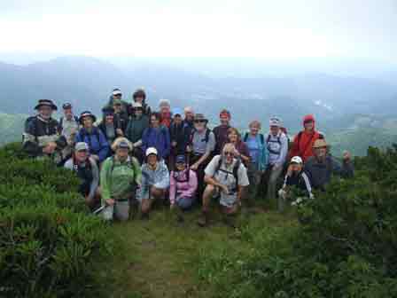
Photo by Karen Rowe Fifteen hikers enjoyed this scenic tour around the perimeter of Graveyard Fields. Good views down into Graveyard Fields and of the surrounding mountains were to be had during the hike. We started from John Rock overlook along the boundary trail, crossing the BRP 3 times before climbing up to the MST. Along the way, there was evidence of a bountiful collection of Painted Trilliums that had bloomed in May. There were also a number of large spruce blowdowns which were downed by a strong windstorm earlier this year. After reaching the MST, we turned north to a lunch spot on a rock cliff with a great view. Later in the hike, the shaded grassy area under a large maple tree at Dark Prong Gap proved inviting enough for an impromptu rest break. Soon after, light-to-moderate rain visited us for the segment to Skinny Dip Falls. When we reached the Falls, only one hiker was brave enough to try wading in the cold water. 9 of the hikers abandoned us here to hike up to Bridges Camp Gap and then home. The rest of us went up the Seniard Mountain ridge and the boundary trail back to our cars, stopping again to enjoy the view to the east over Pilot Mtn.--Bruce Bente
ALL DAY NO. A0802-566 June 29
Photo by Ashok Kudva
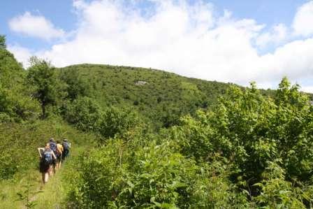
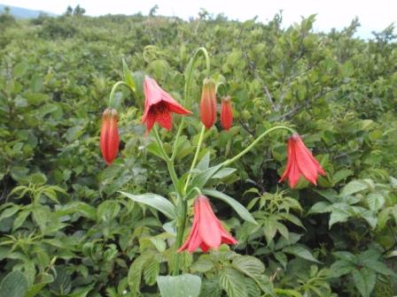
Photo by Bruce Bente This is one of my favorite hikes, one that I signed up for when I attended the Johnson City get-to-gether with ATC before I moved down here. The grassy knobs are so green with tall grasses blowing in the cool crisp breezes and wildflowers in bloom everywhere. It was such a treat to observe the Grey's lillies all over in their glory. The Flame azaleas made their exquisite appearances everywhere. The Cawtauba rhodos had pretty much passed their peak throughout the trail with the exception of a small patch below an overhanging rock. The day was a mixture of sun and clouds rolling in around us with some rain drops several times briefly in the afternoon, but, we were able to photograph gorgeous views of the vallies of farms and an outline of the famous peaks such as Roan, Grandfather, Beech, Craig, Mitchell. After the hike some drove over to the rhododendron gardens at Roan Mountain -- lovely area!! -- Tish Desjardins HALF-DAY No. H0802-453 June 22 On a mostly sunny day, 24 hikers were greeted at Max Patch with loud thunder claps , lightening and rain. It was over in 10 minutes and we had a beautiful hike with threat of rain while we were breaking at AT shelter. We hiked Max Patch trail to top and down AT to Buckeye Ridge Trail. We joined AT again and hiked to shelter. On return we hiked over the top agian. Some wildflowers were identified , as we were fortunate to have Elizabeth Feil with us. This was a much appreciated 5 mile hike. Next year we may make it longer. Some people did not hike because of long drive for short hike.--Gail Lamb HALF-DAY NO. H0802-380 June 29 WEDNESDAY NO. NO. W0802-608 June 25
Photo by Charlie Ferguson
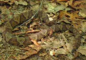
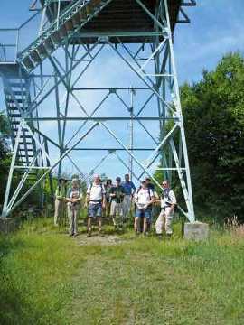
Photo by Ashok Kudva Eleven hikers arrived at Tanyard Gap to begin this hike. Tom Sanders had to forgo leading and Charlie Ferguson led in his place. Jorge Munoz warned us a couple of days before the hike about a yellow jacket nest at the beginning of the hike. It's a little early for yellow jacket problems, we thought. Sure enough, at the second flight of stairs, a few minutes after leaving Tanyard Gap, there was a big hole in the dirt at the fourth step with many very busy bees coming and going. Eleven people walking up the steps would be asking for trouble, so we did a short but difficult bushwhack through the mountain laurels on either side of the steps. We ascended 1200 feet over 2.8 miles to the Rich Mountain Lookout Tower. The climb allowed fast hikers to climb quickly for awhile with waits at trail junctions for the relaxed hikers to catch up. We had a snack at the Lookout tower and briefly introduced the new CMC Lookout Tower Challenge (LTC) which involves hiking to 24 Lookout towers in Western North Carolina. This is an easier challenge and some hikers were enthusiastic about trying it out. After our break we hiked back down part of the AT to Roundtop Ridge trail which is a very nice trail which is in need of some maintenance - parts of it are progressing toward becoming a manway. Part way down the trail we found a Copperhead in the middle of the trail who proceeded to pose for us for a few minutes. Photographers photographed and hikers gave it plenty of room. It be came bored and slinked off the side of the trail. As a switchback turned back in the direction that the snake went , we were careful about proceeding. When we arrived at the French Broad River, we decided to eat lunch right by the river as we were very hungry and the poor seating didn't seem to be a problem. There seems to be a lot of bugs there. After lunch we walked about a half mile along the road to the Silvermine campground where there was a nice picnic table. No sense in eating lunch again just to enjoy the table. We started up the Pump Gap Loop trail. Part way up there was a fork in the trail. We split into two groups 6 on the northern leg and 5 on the southern leg with plans to meet were the loop meets the AT on it's way back to Tanyard Gap. The group of 5 were a lot slower than the others. Someone had to get back to Asheville for an appointment so the northern group proceeded to Tanyard Gap first and left before everyone from the southern group got back. Everyone got back safely and a few had dinner at Westgate after the hike. It was warm and humid but everyone enjoyed it.--Charlie Ferguson WEDNESDAY NO W0803-374 July 2
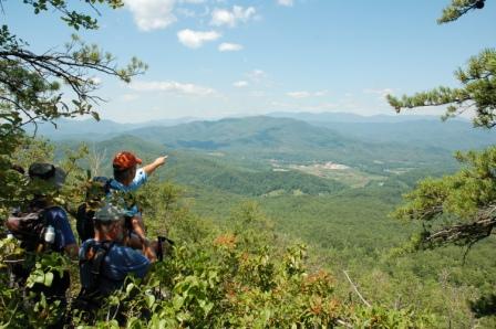
Photo by Ted Conners Twenty-four hikers completed a five mile climb to the summit of Bald Knob in McDowell County. After the new bridge for the MST across the North Fork of the Catawba River withstood our joyous stomping, our senses were treated with blooms of white rhododendron, sun-sweetened blueberries, and intermittent views of the ridgeline of the Black Mountains. Sadly, the view westward included wisps of smoke rising from an apparent forest fire between us and the Blacks. At the lunch stop on a rock outcropping near the summit, the 270 degree view included the Honeycutt Mountains, the Linville Mountains and Lake James in clockwise direction. Nearby, several chestnut saplings were noted. Lunch was followed by a well-paced five mile descent.--Janet Martin All-day hikes submitted by Bruce Bente 692-0116, bbente@bellsouth.net . Driving distance is round-trip from Asheville. All Saturday and Sunday hikes assemble at Westgate Shopping Center near I-240 UNLESS OTHERWISE NOTED. Half Day hikes submitted by Paula Robbins 828-687-1651 paularww@bellsouth.net and Lucy Prim 828-693-6580 lucette32@mchsi.com. Wednesday Hikes are submitted by Charlie Ferguson, 828-398-0213 ccf108@gmail.com and Ann Gleason, 828-859-9387, gleason.ann@gmail.com . The meeting place for each hike will be designated by the hike leader and will appear in the hike description.
Driving mileage will be listed, round trip, from the first designated meeting place. |