All Day Saturday & Sunday
ALL DAY NO. A0901-001 Jan. 11
Case Camp – Seniard Ridge Loop 8:00 AM
Hike 8 or 9.8, Drive 80, 2000 ft. ascent, Rated A-A
Cindy McJunkin, 828-712-9646, mcjfive@aol.com
P400 This loop hike features a short steep climb up to the MST, some MST hiking, and 50-ft. frozen cascades along the closed BRP. Possible additional distance to see additional ice sheets, depending upon weather. After lunch with a great view of the surrounding mountains, we’ll hike through some beautiful woods on the Seniard Ridge trail. Second meeting place: Pisgah Ranger Station at 8:30 AM. Topo: Shining Rock; also pg. 50 of MST Profiles book and Nat’l. Geo. PRD map #780
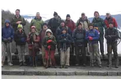 
--Photos by Cindy McJunkin
The hardest part about leading this hike has been choosing from all the great pictures! The best part was the pleasant company. We had a brief aerobic challenge climbing from Headwaters Road to the Parkway, and a bit more up to and along the MST. After some discussion about a woods route vs. the closed parkway, we continued to the Parkway, which was closed. Although we missed the fifty foot ice sculptures, a few of us broke off some cones while the rest of us made sure we stayed clear of the melting pieces that kept shattering from the rock face and falling onto the road.
At the East Fork Overlook, we could hear the falls in the gorge below us, but the clouds obscured our view. While we were eating, the clouds moved around so that we could see a few peaks here and there, and most of us were ready with cameras, hoping for a good entry for the photo contest. We had a steep descent down Seniard Ridge, with a few peeks at Looking Glass along the way. We continued through a tunnel of mountain laurel and crossed the creek twice, finding that what had been a trail was now a logging road with open areas and unusual views of Looking Glass. Before we were done, we passed two waterfalls, which no one in the group knew the names of, so we created our own….High Step Falls, Benson Falls? A final section pulled us back up to Case Cove Ridge and then back down to our trailhead. Look for more photos from other CMC photographers, which will surely be submitted for the contest!--Cindy McJunkin.
ALL DAY NO. A0901-203 Jan. 18
Tanyard Gap –AT – Lovers Leap – Pump Gap loop *9:00 AM
Hike 9, Drive 70, 2200 ft. ascent, Rated A-AA
Tish Desjardins, 828-656-2191, desraylet@aol.com
*Note later start time. After the hike there will be a potluck supper in the nearby Bear River Community Lodge. Hikers are requested to contribute food for the supper. Food will be taken to a refrigerator before the hike. Please phone the leader to coordinate what food to bring. We’ll do a moderate loop in the Hot Springs area, starting and ending at Tanyard Gap. We’ll start on the AT up to Mill Ridge, then continue over Lovers Leap down to the river. Next we’ll road-walk to the Silvermine Trailhead and take the Pump Gap Trail back up to the AT and retrace our steps to Tanyard Gap. Topo: Hot Springs
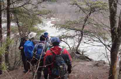
Photo by Bruce Bente
Ten of us enjoyed a 9 mile hike from Tanyard Gap on the AT southbound and over Lover's Leap in Hot Springs and onward to Silvermine Rd. to the Pump Gap trail and A.T. northbound back to Tanyard Gap. Conditions early in the morning were slippery in some spots; the leader wore stabilizers, which are highly recommended to avoid slipping, over her hiking boots . It started snowing lightly around one o'clock. The rest of the day was sunny and milder with hardly any slippery areas left. The French Broad River was nice and high and pushing along in full force. Encountered five blowdowns on the A.T. Potluck around a cozy fireplace followed the hike.--Tish Desjardins
--Back to Top
Half Day Sunday
HALF-DAY NO. H0901-434 Jan. 11
Laurel Mountain Trail *12:30 PM
Hike 5.4 miles, Drive 40, 700 ft. ascent, Rated C-C
Nonmembers, call leader, Greg Goodman, 828-684-9703, greggoodman@bellsouth.net
P400 *Note early start time. Meet at Westgate at 12:30 PM to form carpools, and meet leader at the North Mills River parking area at 1:00 PM. This loop hike will start at FS 1206, go along a ridge trail toward Black Mountain, and return via the Laurel Mountain Trail. There should be good views of the Mills River Valley.
great hike fog moved in snowed on us at the top bk mt seeye greg --Greg Goodman
HALF-DAY NO. H0901-381 Jan. 18
Snowball Trail *12:30 PM
Hike 5.5, Drive 50, 900 ft. ascent, Rated B-B
Nonmembers call leader, Jorge Munoz, 828-658-0606, jmunoz@buncombe.main.nc.us
*Note early start time. This is a moderate in-and-out hike with a steady climb (some hikers consider it to be steep) to High Rocks (Hawkbill Mtn.). Diverse and centennial trees to be admired all the way on the ridge. Stop for a snack at Snowball Mountain before return. Second meeting place: Craven Gap on Blue Ridge Parkway at 12:50 PM.
--Back to Top
All Day Wednesday
WEDNESDAY NO. W0901-101 Jan. 14
Big Laurel River *8:45 AM
Hike 7, Drive 60, 300 ft. ascent, Rated C-C
Becky Elston, 828-749-1886, belston@cytechusa.com
Trail follows Big Laurel River to the confluence with the French Broad River, lunch here. Pass thru Runion, which was a thriving logging town in the early 1900's. Fairly rocky in spots. *Meet at Westgate at 8:45 AM to form carpools, and meet leader at Ingles on US 25/70 at the Marshall Bypass at 9:30 AM. Topo: Hot Springs
WEDNESDAY NO. W0901-053 Jan. 21
East Fork Pigeon River *8:30 AM
Hike 7.5, Drive 74, 1200 ft. ascent, Rated B-B
Barbara Morgan, 828-738-3395, bcmorg@hughes.net
P400 *Wilderness area, limit 10, so contact leader for reservation. A stroll along one of WNC's most beautiful streams, the East Fork of the Pigeon River, which is often spectacular in the winter. We will ascend to Dark Prong for lunch and then return. Second meeting place: Big East parking area on US 276, north of BRP at 9:15 AM. Topo: Shining Rock; also Nat’l. Geo. PRD map #780
--Back to Top
All-day hikes submitted by Bruce Bente 692-0116, bbente@bellsouth.net . Driving distance is round-trip from Asheville. All Saturday and Sunday hikes assemble at Westgate Shopping Center near I-240 UNLESS OTHERWISE NOTED.
Half Day hikes submitted by Lucy Prim 828-693-6580 lucette32@mchsi.com.
Wednesday Hikes are submitted by Charlie Ferguson, 828-398-0213 ccf108@gmail.com and Ann Gleason, 828-859-9387,
gleason.ann@gmail.com .
The meeting place for each hike will be designated by the hike leader and will appear in the hike description.
Driving mileage will be listed, round trip, from the first designated meeting place.
Leaders: Mail please mail your sign-up sheets. Meet at Westgate unless otherwise noted. |