CMC Bi-Weekly Hike Reports
August 21, 2009 -- Looking Back
| Half Day Sunday Hikes |
| Wednesday Hikes |
All Day Saturday & Sunday ALL DAY NO. W0903-214 Aug. 2 Eight members of CMC showed up on a very wet Sunday morning to hike Ramsey Creek trail up to the A.T. and Standing Indian Mountain. Rain diminished as we started our hike up, and though the day remained soggy, by the time we descended from Standing Indian along the Lower Ridge Trail, we were experiencing blue skies and drying breezes. Standing Indian was socked in by thick, moist cloud cover, so we missed one of the most outstanding views in this part of western North Carolina, but the incredible display of summer wildflowers and remnant old growth forest along the Lower Ridge Trail more than made up for it. Kimsey Creek trail was in good condition, and Lower Ridge Trail, though overgrown and thickly vegetated at points, was also well marked and passable.--Brent Martin ALL DAY NO. A0903-652 Aug. 2
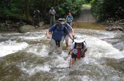
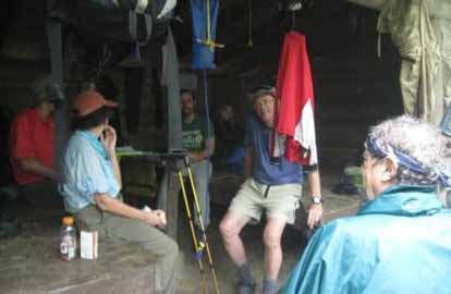
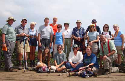
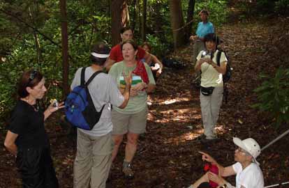
Photos by Don Walton Eight souls, unafraid of rain, started the moderate 7 mile hike on the A.T. and through the new Rocky Fork Tract. We lunched at the Flint Gap Shelter with 4 other section hikers waiting out the rain. We left the shelter at 12:30 in the rain headed for the Flint Gap, our entrance into the Rocky Fork Tract. We found the old path down to the road and the first of 13 stream crossings. The forecast before we left included that the Shelton Laurel Streams were swollen from the rains. The forecast was correct. In addition to the streams being more challenging, the old road we were following has suffered heavy water erosion this spring and summer. Being veteran water jumpers we welcomed the swollen streams. Additionally on our hike from Flint Gap we envisioned Colonel Sevier’s January 10, 1788 march through Flint Gap and our path down to the Flint Creek/Rocky Fork Creek Junction to the scene of the “Last Battle of the State of Franklin”; “the bloodiest of all fights in the Cherokee Wars”. We still had the biggest number “13” stream crossing at Rocky Fork Creek, the largest creek in Rocky Fork. As the pictures tell, we safely crossed with determination and sure footedness, all getting wet up to different levels depending on height.--Don Walton ALL DAY NO. A0903-068 Aug. 9 SATURDAY NO. A0903-369 Aug. 15 ALL DAY NO. A0903-267 Aug. 16 With hopes of good weather, 19 hikers headed to Horsepasture River for a day of waterfall viewing and swimming. The relocation of the parking lot in Gorges State Park has changed the route of this hike for the better. Though the waterfalls are not located within the park, a nicely graveled, shady trail leads from the parking lot down toward the river and into the Pisgah National Forest trail network. This nice trail replaces the rocky gully formerly used to access the waterfalls. After a steep climb down and back to view Stairway Falls, we passed by the impressive Rainbow Falls, and Turtleback Falls. Since it was early there were few swimmers enjoying the slide off Turtleback. We headed on up to Drift Falls, now on private property but still viewable from behind the posted signs. Dark clouds were building so we hurried back to our swimming hole/lunch spot below at Hidden Falls located below Rainbow. By the time we arrived, though, the clouds had scooted on by for us to enjoy a great swim in the sun. Some even enjoyed getting behind the waterfall and looking out through the water. There were also lots of fish to observe. After lunch we headed down to Windy Falls for another dip and some relaxing on the rocks. We were soberly reminded, though, of the ever-present danger waterfalls present by a plaque someone had nailed to a tree. It contained both a memorial to a young man who had lost his life there and a warning to visitors about the slippery rocks. After a challenging hike back up the “quite unmaintained” trail from Windy to the nice gravel trail in the park, we returned to our cars for a farewell bite of watermelon, having enjoyed what one of the hikers had said was the opportunity to “feel like a kid again!” --Kathleen Hannigan HALF-DAY NO. H0903-573 Aug. 2 The weather reports all day were extremely threatening with rain (lots of rain) and thunder and lightening. But weather predictability in the mountains is always iffy and we took a chance and had 7 adventuresome souls on what turned out to be a fantastic hike with clear views from Devil's Courthouse and not a drop of rain.--Becky Elston The Mt. Pisgah hike was my first as hike leader. Lucy Prim recruited me, led me every step of the way, and took care of every detail. She even scouted the hike with me. With Lucy behind the scenes, so competent and generous of spirit, I see why the club is so successful. The hike went off without mishap. I think some of us gained a new respect for what an “easy” C-C hike with “only” 700’ elevation gain can mean (seemed like a 1,000 flights of stairs to me.) Clearly, I stand to benefit from more hiking! This picture at the summit shows that the August haze was in full force, but the view and relief of reaching summit were still wonderful.--Laura Frisbie
Photo by Virginia Hodge HALF-DAY NO. H0903-602 Aug. 16 WEDNESDAY NO. W0903-405 July 29 There were 11 hikers who completed this in and out hike which started at the Mills River Overlook and used part of the Shut In Trail (also MST) to access the Pisgah Inn area. Although there was a threat of rain, nothing much came of it and we were rewarded with sunny skies and views by the end of the hike. We enjoyed lots of Turks' Cap lilies and Black Cohosh flowers, as well as some interesting bright orange fungi. My thanks go to Ashok Kudva for using his GPS to create updated information for the hike as well as additional information on the history of the now-dismantled Buck Springs Lodge and to Keiko Merl for serving as sweep. WEDNESDAY NO. W0903-560 Aug. 5
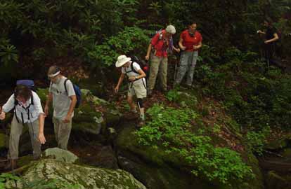
Photos by Stuart English Nineteen people started from Brown Gap down FS 357 to intersect Rube Rock Trail and hike down into the Pigeon River Gorge above Interstate 40 from Harmon Den Mountain. This hike has been delayed since early in the year because of weather and trail conditions. This summer, however, a volunteer trail crew cleaned up the Rube Rock Trail considerably. We could actually tell where we were going as we descended that elevator shaft and began to hear the sounds of traffic on the Interstate. At the junction of Rube Rock and Groundhog Creek Trails, we met Charlie Ferguson and Jeannie Danner who arriving late, had gone counter clock wise and met us. They accompanied us the rest of the way. It was a hot, humid day and by the time we started the climb out of the gorge, most of us were soaking wet. We ate lunch at the Groundhog Creek shelter. As we climbed the last three miles back on the AT to our cars, it began raining lightly. There was no lightning though, and it felt good. Some of us made a brief side trip near the end to visit Hawks Roost: a view point with a plaque commemorating conservation efforts here by the club. This is not a summer hike. It would be better in Fall or early Spring.--Stuart English WEDNESDAY NO. W0903-475 Aug. 12 WEDNESDAY NO. W0903-142 Aug. 19 Reports for Wednesday hikes during the eNews publication week will appear in the following eNews--The Editor. All-day hikes submitted by Bruce Bente 692-0116, bbente@bellsouth.net . Driving distance is round-trip from Asheville. All Saturday and Sunday hikes assemble at Westgate Shopping Center near I-240 UNLESS OTHERWISE NOTED. Half Day hikes submitted by Lucy Prim 828-693-6580 lucette32@mchsi.com. Wednesday Hikes are submitted by Charlie Ferguson, 828-398-0213 ccf108@gmail.com and Ann Gleason, 828-859-9387, gleason.ann@gmail.com . The meeting place for each hike will be designated by the hike leader and will appear in the hike description.
Driving mileage will be listed, round trip, from the first designated meeting place.
|