
CMC Weekly Hike News
04/13/05
__________________________________________________________________________________
Looking Ahead....
All Day Saturday & Sunday
ALL DAY No. A0502-444 Apr. 17 Avery Creek Loop 8:00 AM Hike 10, Drive 75, 1500 ft. ascent, Rated A-A Chip Miller 828-298-4449 backpacker54nc@bellsouth.net P400 We’ll climb the Avery Gap and Buckhorn Gap trails to Buckhorn Gap, passing by Twin Falls. Next will be the Black Mtn. trail to Club Gap, with return downhill on the Avery Creek Trail. Second meeting place: Pisgah Ranger Station at 8:30 AM. Topos: Pisgah Forest, Shining Rock; also Nat’l. Geographic Pisgah Ranger District map
All-day hikes submitted by Bruce Bente 692-0116, bbente@cytechusa.com . Driving distance is round-trip from Asheville. All Saturday and Sunday hikes assemble at Westgate Shopping Center near I-240 UNLESS OTHERWISE NOTED.
Half Day Sunday
Half Day Hike No. H0502-162 April 17 Mt. Pisgah from Elk Pasture Gap 1:00 PM Hike 5.5, Drive 30, Rated C-A Elisabeth Feil 828-684-8719 hofeil@brinet.com P400 Note early start time. This moderate car-shuttle hike starts at Elk Pasture Gap (BRP and NC 151). The first two miles up to Little Pisgah Mtn. are steep (1100 ft in two miles). Then we'll descend to the Mt. Pisgah parking lot and climb another 700+ feet to the summit. Great views in good weather. Return from the parking lot. Second meeting place Mt. Pisgah Parking Lot.
Half Day hikes submitted by Paula Robbins 828-687-1651 paularww@bellsouth.net and Pat Elias 828-281-3253 patelias@bellsouth.net . Leaders: Mail please mail your sign-up sheets. Meet at Westgate unless otherwise noted.
All Day Wednesday
WEDNESDAY No. W0502-455 Apr. 20 Lower Mt Cammerer Trail 8:00 AM Hike 8, Drive 120, 1000 ft. ascent, Rated B-C Tom Sanders, 828-252-6327 mel&tgs@main.nc.us This moderate in and out hike from the Cosby Camp Ground area of the Great Smokies hopefully will coincide with yellow Trillium, Showy Orchis and Dwarf Iris which thrive here in late April. In any event, Lower Cammerer is a beautiful trail with a gradual incline up and then down. Second meeting place: Pilot Truck stop at Exit 24 of I-40 at 8:30 AM Topo: Hartford
WEDNESDAY No. W0502-120 Apr. 27 Charlies’ Bunion-Kephart Prong 8:00 AM Hike 10.2, Drive 140, 1500 ft. ascent, Rated A-B Elisabeth Feil, 828-684-8719 hofeil@brinet.com 900M, SB6K? An outstanding rock outcrop along the AT, stunning views, and a great wildflower display are the highlights of the trip. Starting at Newfound Gap, we hike 4 miles to the Bunion, then along Dry Sluice Gap, Grassy Branch and Kephart Prong Trails down to US 441. (There is an optional side trip over Mt. Kephart (6000 ft) to The Jumpoff, which adds another 2 miles. We’ll make our decision when we get there.) This hike is moderate to strenuous about 1500 ft uphill and 2800 ft down. Car shuttle. Second meeting place: Quality Inn at Junction US 19 and US 276 in Maggie Valley at 8:40 am. Topos: Clingmans Dome, Mt Guyot, Smokemont; also Nat’l. Geographic GSMNP map
Wednesday Hikes are submitted by Paula McNabb, 828- 274-0057 gcmcnabb@charter.net and Ann Gleason, 828-859-9387, cowbonetail@yahoo.com . The meeting place for each hike will be designated by the hike leader and will appear in the hike description. Driving mileage will be listed, round trip, from the first designated meeting place.
_________________________________________________________________________
Looking Back......
ALL DAY No. A0502-443 Apr. 10 Pine Mtn. Loop 8:00 AM Hike 9-10, Drive 50, 2200 ft. ascent, Rated A-AA Tom Bindrim & Joan Lemire 828-299-1572 P400 From North Mills River area, we’ll ascend Seniard Mtn. to Double Head and Pine Mtn. (the one with the BRP tunnel) and return through Bent Creek Gap, Bad Fork Hollow and Wash Creek. Some off-trail hiking. Topo: Dunsmore Mtn.; also Nat’l. Geographic Pisgah Ranger District map
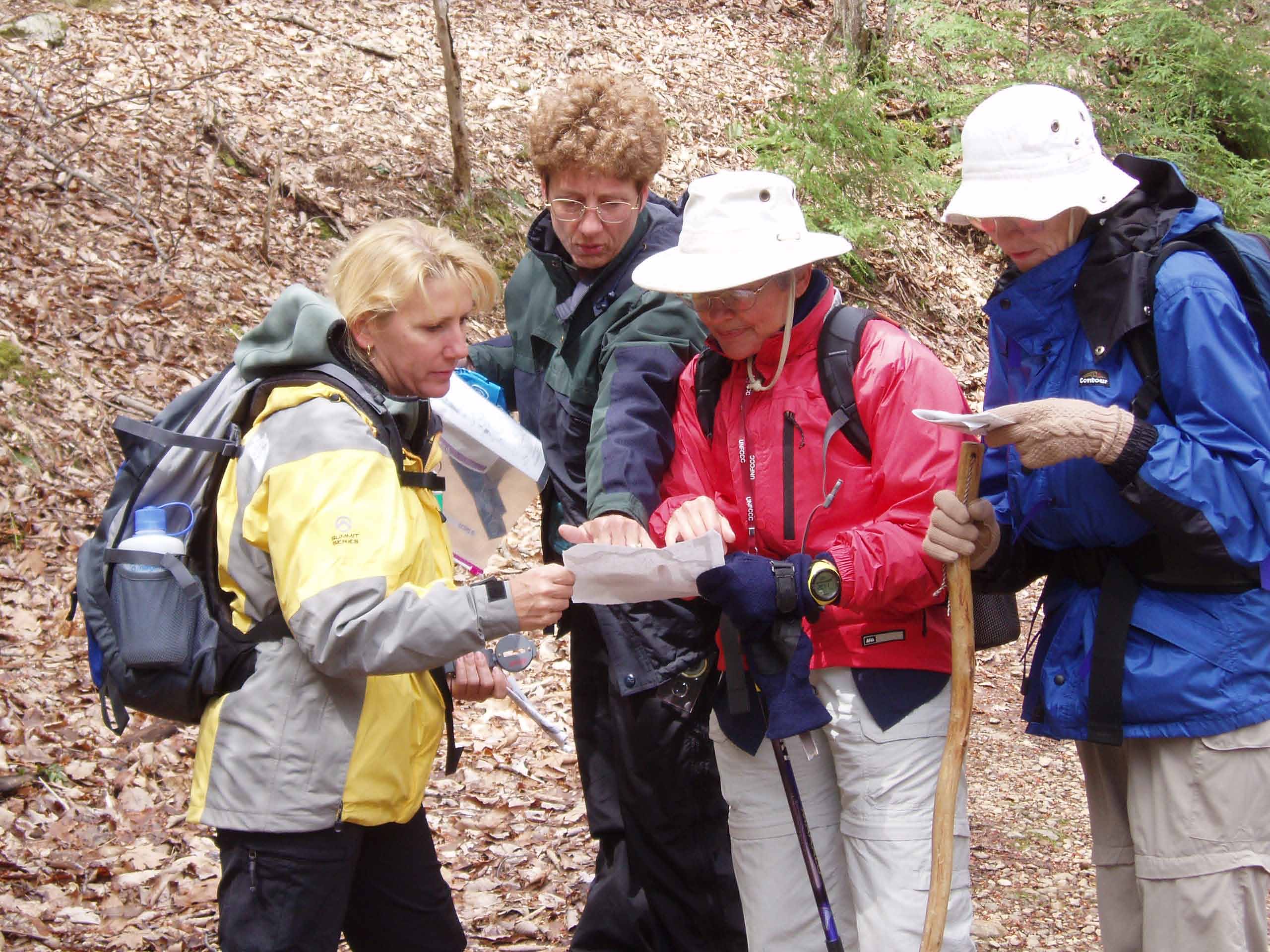
Map-Reading Course Apr. 2 Dave Wetmore and Tom Bindrim 828-884-7296 dwetmore@citcom.net Attendees must bring a compass and a Forest Service edition of the Dunsmore Mtn. topo map. The map can be bought either at the Pisgah Ranger Station near Brevard or at the Forest Supervisor’s office in Asheville on Zillicoa St., across Broadway from the UNCA Botanical Gardens. There will be a short informal class, followed by a practical exercise. Please contact Dave Wetmore for information on the meeting time and to register. You must register before the course, as we need to know the number going. No walk-ins please. Topo: Dunsmore Mtn.
Post Hike Report: Map Reading course Do you know where you are on the trail? Do you know where you have been and most importantly do you know where you are going? On the map reading course led by Dave Wetmore and Tom Bindrim, these were not philosophical questions but practical ones. Eight students - all leaders - met to learn how to answer these questions. Becky Johnson from the Smoky Mountain News also attended. Armed with compasses and a Forest Service edition of the Dunsmore Mtn. topo map, we met at Earthfare for a classroom lecture. Dave and Tom had prepared class notes where we dissected contour lines, ridgelines, grades, creek, gaps and draws. Tom emphasized that our club motto was "Let's Go" but when you think you are lost, the most important thing is to "stop and think". Then it was time to get some practical experience. We were divided into two groups alphabetically and we went out to Bent Creek. I ended up in Dave's group but both groups did the same mini hike. As we walked, Dave kept posing questions and sometimes told us that we had our head in the map too often and we were not looking at our compasses enough. We stopped often and tried to predict what the trail ahead would look like. Would it be steep? Where would the creek cross? As we kept all those balls in the air, the weather deteriorated to rain, snow and a little sleet. Our paper maps were hard to handle with thick gloves and were falling apart. Tom had shown us his system of map preservation which I will use for topo maps. When we got back to the cars, we decided that the course had been definitely worthwhile. I learned a lot of vocabulary and principles. I hope that Dave and Tom run the course again for others and run a more advanced one for us. Danny danny@hikertohiker.org
ALL DAY No. A0502-427 Apr. 3 Soapstone Ridge 8:30 AM (strenuous) Hike 10, Drive 90, 1200 ft. ascent, Rated A-B Stuart Tauber 828-254-0824 sdtauber@charter.net P400 Note later start time and that this is the first day of DST. This new CMC hike will begin at the gauging station and follow a mild bushwhack up Soapstone Ridge to the Alternate MST. We’ll follow the AMST to the Black Mtn. Trail to our lunch spot at Buckhorn Shelter, and then take the Buckhorn Gap trail down to the S. Mills River trail back to our cars. The leader may make some revisions to the route depending on the group and weather. Expect a fast-paced hike. Topos: Pisgah Forest, Shining Rock; also Nat’l. Geographic Pisgah Ranger District map
Post Hike Report: Five members of the CMC joined the hike leader at 8:30 a.m. DST at Westgate. We drove to the trailhead at the Gauging Station through Pisgah Forest since of the high winds of the previous night had caused some blowdowns and a temporary closing of the Parkway. The hike began at 9:50 a.m. with high winds roaring above the ridge but with beautiful sun and crystal clear water rushing in the South fork of the Mills River. The hike proceeded down the Mills River Trail to reach a junction which the hike leader had explored earlier. The route up the slope to Soapstone Ridge was glorious with brilliant light illuminating the cove and of making the view of the distant ridge brilliant and clear. Following this new route we reached the alternate mountains to the sea trail and proceeded North through two tricky junctions to reach the Black Mountain Trail/MST. Frying Pan Mountain, Pisgah, Little Pisgah and other mountain peaks were identified. The hike continued on the ridge and all enjoyed the beautiful views of this brilliant day. By the time we reached Buckhorn shelter, the lunch spot, the wind had died down considerably and the day grew progressively warmer. Following lunch we proceeded to Buckhorn gap and down the Buckhorn Trail to reach the Mills River Trail, passing the junction which had led up to Soapstone Ridge. We returned up the Mills River trail to arrive at the trailhead at 2:41 p.m. The GPS recordings indicated a total ascent of 2500 feet with a route of 10 miles. Stuart
ALL DAY No. A0502-428 Apr. 3 Cane River Gap to Little Butt 9:00 AM (moderate) Hike 7.5, Drive 50, 2200 ft. ascent, Rated B-AA Les Love 828-658-1489 lesrlove@aol.com Note later start time and that this is the first day of DST. This hike begins with a 1200 ft. ascent to the ridgeline, then along the top of the ridge with a few gradual ups-and-downs. After reaching Big Butt, we’ll follow the narrow ridgeline with its views to our lunch spot at Little Butt, which has a great view of the Black Mtns. across the valley. Return via the same route. Topo: Mt. Mitchell
Post Hike Report: Four of us showed for the
hike to Little Butt. We knew there would be some snow, but had no idea it would
be so deep for the beginning of April. Drifts were above our knees and the
snowfall was over 12". It was 33 degrees when we left the car at the gap and got
colder as we went up, with 30 mph winds and gusts up to 60 mph. We only made it
to the climb up Big Butt, found a sheltered area, hunkered down for lunch, then
made our way back for an early return. Temps. were in the high 50s when we got
back down in the valley. An invigorating spring adventure! Les
Half Day Sunday
HALF-DAY No. H0502-101 Apr. 10 Lower Big Laurel Creek Wildflower Stroll Noon Hike 6, Drive 60, 200-ft ascent, Rated B-C Diane Hankins, 828-298-2870 (before 9 PM) Note early start time. Leisurely paced in-and-out hike along Lower Big Laurel Creek to the site of Runion, an early 1900s settlement. Suitable for anyone over 10 years of age (those under 18 MUST be accompanied by an adult). We’ll take time to identify the flowers we see. Long pants suggested (poison ivy sprouts early).
All Day Wednesday
WEDNESDAY No. W0502-164 Apr. 13 Hawkbill Creek-Little Snowball Loop 8:00 AM* Hike 8-9, Drive 50, 2235 ft. ascent, Rated B-AA Tom Bindrim, 828-299-1572 Beaucoup wildflowers if our timing is right, cascading water, pick some ramps, nice scenery from Hawkbill Rock and Little Snowball, some off-trail, moderately paced. *Only meeting place: Rear parking lot at Folk Art Center at 8:00 AM. Topo: Craggy Pinnacle
HikingNews....
_____________________________________________________________
Excursion Leaders needed for Southern ATC Biennial 2005
Join New CMC Hike Information Message Center!
The CMC is starting a Hike Information exchange system on www.Yahoo.com which can be used to exchange information relating to hiking. This group system is intended to help coordinate off schedule hiking activities that benefit the club and it's members. For example, a hike leader may need to scout a hike but cannot find anyone to go along or maybe someone needs directional help to adequately hike a trail.
The email address used to communicate is cmchikeinfo@yahoogroups.com . The address to use to join is: http://groups.yahoo.com/group/cmchikeinfo/ You have to be a yahoo member (free) to join. When you join you will need to provide your name in the setup in the "Real Name" field. This is desirable for people to know who you are. If you have any questions please contact me. Don Walton