
CMC Bi-Weekly Hike News
05/11/05
__________________________________________________________________________________
Looking Ahead....
All Day Saturday & Sunday
ALL DAY No. A0502-100 May 15 Cheoah Bald via Bartram Trail 7:30 AM Hike 12-13, Drive 140, 3100 ft. ascent, Rated AA-AA+ Linda Beja 828-293-3849 lrbeja@earthlink.net Note early start time. This strenuous hike will climb up and out of the Nantahala Gorge, offering a unique approach to the open summit of Cheoah Bald, one of the great scenic peaks south of the Smokies. Our return will be via the AT to NOC. Second meeting place: NOC, across new bridge at 9:00 AM. Topo: Hewitt; also Nat’l. Geographic Nantahala & Cullasaja Gorges map
ALL DAY No. A0502-214 May 22 Standing Indian Circuit 7:30 AM Hike 10, Drive 150, 2300 ft. ascent, Rated A-AA Bill Ross 828-271-7992 wrossmath@cs.com Note earlier starting time. The Standing Indian area in the Nantahala National Forest is known for its beautiful forest, rushing streams and excellent vistas. We’ll hike up the Kimsey Creek Trail to the AT, and the AT to our lunch spot, Standing Indian. At 5498 ft., it is the highest mountain on the AT south of the Great Smoky Mountains, with outstanding views. We’ll return on the Ridge Trail. Second meeting place: Rest Stop beyond Waynesville on US 23/74 at 8:00 AM. Topo: Rainbow Springs
All-day hikes submitted by Bruce Bente 692-0116, bbente@cytechusa.com . Driving distance is round-trip from Asheville. All Saturday and Sunday hikes assemble at Westgate Shopping Center near I-240 UNLESS OTHERWISE NOTED.
Half Day Sunday
HALF DAY No. H0502-452 May 15 Dupont Forest: Fawn Lake P.L. #4 12:30 PM* Hike 6, Drive 94, Rated B-C Becky Elston 828-749-1886 belston@cytechusa.com Note early start time. A pleasant loop with break at the bottom of Bridal Veil Falls. Weather and conditions permitting, we can walk behind the falls. Meet at 12:30 PM at Westgate to form carpools, and meet leader at Hooker Falls Parking Area at 1:30 PM.
HALF DAY No. H0502-384 May 22 Black Balsam Road to Looking Glass Overlook 12:30 PM Hike 5.3, Drive 65, 1300-ft. ascent, Rated C-B Ruth Hartzler 828-251-0886 ruthmtn@aol.com P400 Note early start time. Hike from Black Balsam Road (FS816) via Graveyard Fields and Skinny Dip Falls to Looking Glass Overlook. Short car shuttle. Second Meeting Place: BRP Cold Mountain Overlook at 1:15 PM. Topo: Shining Rock; also Nat’l. Geographic Pisgah Ranger District map.
Half Day hikes submitted by Paula Robbins 828-687-1651 paularww@bellsouth.net and Pat Elias 828-281-3253 patelias@bellsouth.net . Leaders: Mail please mail your sign-up sheets. Meet at Westgate unless otherwise noted.
All Day Wednesday
WEDNESDAY No. W0502-456 May 11 AT: Stecoah Gap to Yellow Creek Gap 8:00 AM Hike 7.6, Drive 170, 1700 ft. ascent, Rated B-A Jack Fitzgerald, 828-685-2897 suejackfitz@bellsouth.net A moderate hike on the southern portion of the AT, between Stecoah Gap and Yellow Creek Gap. Guaranteed to see lots of wildflowers, including the rare yellow trillium and yellow ladyslipper. There will be a car key switch. Topos: Hewitt, Fontana Dam
WEDNESDAY No. W0502-457 May 18 AT: Brown Gap to Max Patch and return 8:15 AM Hike 7, Drive 100, 1100 ft. ascent, Rated B-B Ken & Carol Deal 828-281-4530 KMCDeal@aol.com Note later start time. An in and out hike on the AT, with a steep uphill for the first mile, then leveling off into moderate ups and downs, with a final climb to the top of Max Patch for lunch. If we’re lucky, it will be clear for the beautiful views. Second meeting place: Pilot Truck Stop, exit 24, off I-40 at 9:00 AM. Topo: Lemon Gap
WEDNESDAY No. W0502-458 May 25 Moonshine Cave Falls-The Dismal Trail 8:00 AM* Hike 9, Drive 95, 1200 ft. ascent, Rated B-B Ellie Thrush 828-697-9743 treehouse@highstream.net An in and out hike on Raven Cliff Falls Trail to the Dismal and on to an interesting waterfall. Mostly level with some rolling ups and downs. Only climb is the Dismal Trail. (NOTE: $2 fee per person for park entry Meet at Westgate at 8:00 AM to form carpools, and meet leader at Raven Cliff Falls parking lot on US 276 at 9 AM. Topo: Table Rock; also Mountain Bridge Wilderness map.
Wednesday Hikes are submitted by Paula McNabb, 828- 274-0057 gcmcnabb@charter.net and Ann Gleason, 828-859-9387, cowbonetail@yahoo.com . The meeting place for each hike will be designated by the hike leader and will appear in the hike description. Driving mileage will be listed, round trip, from the first designated meeting place.
_________________________________________________________________________
Looking Back......
WEEKEND No. A0502-446 May 6-8 Camping Weekend in the Smokies Friday evening Drive 200 Danny Bernstein 828-236-0192 danny@hikertohiker.org 900M Come and join us on a camping and hiking weekend based at a private campground in Townsend, just outside Great Smoky Mtns. Nat’l. Park. Participants must bring their own camping equipment. Register with the leader as soon as possible, as this weekend will fill up quickly. The cost is $26. Saturday: We will hike from the Abrams Creek entrance to the park. Two different levels of hikes will be offered; a moderate hike of 6-9 miles and a challenging hike of over 12 miles. Sunday: Hikes will be offered from the Cades Cove and Abrams Creek entrances. As an alternate, you may prefer to tour Cades Cove on your own. Topos: Wear Cove, Thunderhead Mtn., Cades Cove, Gatlinburg ; also Nat’l Geographic GSMNP map.
Post Hike Report:
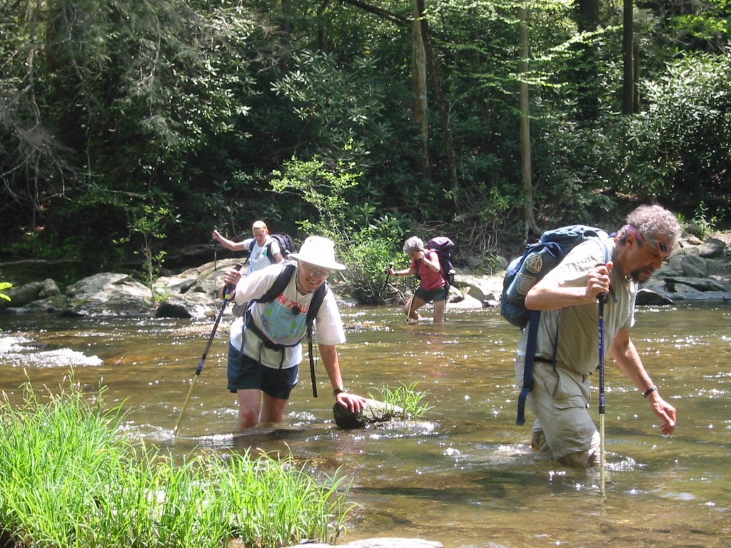
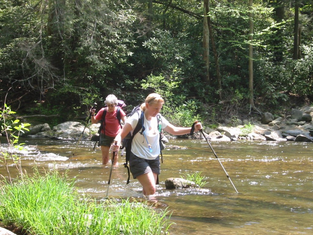
The CMC Smokies Camping trip was success. A diverse group gathered in Townsend, TN to hike, talk, sing, eat and drink The weather was great - blue skies and shorts and t-shirt temperatures. The campgrounds gave us our own tenting area and the flowers were at their peak: irises, several types of trilliums, stonecrop and pink lady slippers and more. See http://www.hikertohiker.org/tsmokies/ The hiking was concentrated on the far western end of the Smokies at the Abrams Creek and Gold Mine entrances. This area, though the furthest from Asheville, is not as remote as it seems from looking at a map. Historically, the settlers living in Cades Cove came out of the cove through that area to get to Maryville, the big city. One of trails that we walked is named the Cooper Road Trail. Saturday, Bruce Bente led the moderate hike to Abrams Falls from Abrams Creek. Linda Beja and Don Gardner led the strenuous hike as a key swap, one group from Ace Gap and the other from Gold Mine. These entrances are not easy to find. Both Linda and Danny spent time before the weekend, separately,searching for the various entrances. Sunday, Linda led the strenuous hike through various trails in the Abrams Creek area. After about eight miles, we had a challenging water crossing; see photos taken by Danny. We all managed to cross without falling in. Bruce and his group went to Cades Cove to do the Rich Mountain Loop. Danny gave out some information about the traffic issues in Cades Cove which affect us all as hikers. The National Park Service is proposing several alternatives to handle the bumper to bumper traffic in the Cove and is soliciting input from the interested public. See http://www.cadescoveplanning.com/ and click on the newsletter for the summary of the alternatives. In a few years, we want to feel that we had some input and not that some “they” made the decision. Now let's all think about going to the Fontana Weekend organized by Bruce. It will be held on Sept. 30 to Oct. 2
ALL DAY No. A0502-445 May 1 Pilot Mtn., Farlow Gap, Daniel Creek Trails 8:00 AM (strenuous) Hike 11, Drive 90, 1900 ft. ascent, Rated A-A Ruth Hartzler 828-251-0886 ruthmtn@aol.com P400 If our timing is right we will enjoy rare pink shell azaleas on Pilot Mtn. This diversified hike features good views from Pilot Mtn. and the beautiful Farlow Gap and Daniel Creek Trails. Second meeting place: Bi-Lo parking lot in Pisgah Forest at 8:30 AM. Topo: Shining Rock; also Nat’l. Geographic Pisgah Ranger District map
Hike Change Due to Road Closure
Pilot Mountain-Farlow Gap 8:00 AM (moderate) Hike 8, Drive 100, 2200 ft. ascent, Rated A-A Ruth Hartzler 828-251-0886 ruthmtn@aol.com P400 If our timing is right we will enjoy rare pink shell azaleas on Pilot Mtn. and a blanket of Trout Lillies at Farlow Gap. This hike features a steep 1800’ climb, then great views from Pilot Mtn. We will continue to Farlow Gap and return via a road and the Art Loeb Trail. Second meeting place: Bi-Lo parking lot in Pisgah Forest at 8:30 AM. Topo: Shining Rock; also Nat’l. Geographic Pisgah Ranger District map.
(While scouting this hike, we ran into two FS engineers, who said contractors were preparing to repair 475. The engineers were from Wyoming, part of a group brought in from the west to work on storm-damaged FS roads in WNC.)
Post Hike Report: Three car loads from Westgate met a group at Pisgah Forest. We then drove through Brevard to NC 215 and Shoal Creek Road to Gloucester Gap. When we scouted, we tried Cathey Creek Road, which was full of potholes, very slow and not recommended. The route was modified due to closure of FS 475. At Gloucester Gap, two additional hikers joined us for a total of 17 spirited hikers ready to enjoy a perfect spring day. The sun was shining, breeze blowing, flowers blooming. Wow! On the steep, 1800’ climb up Pilot Mountain, we saw lots of Wild Oats, violets, several wood anemones and a single dwarf iris. We stopped for a snack at an overlook with expansive views, and continued the trek to the top of Pilot Mountain. Several hikers reported spotting a rare Pink Shell Azalea just blooming. We reached the summit a little early, allowing us to eat lunch while enjoying the spectacular 360-degree views from Pilot Mountain. There was lots of picture-taking, some of which will be posted on the CMC website.
We headed down to Deep Gap, passing several budding Pink Shells. We bypassed the shelter and crested Sassafras Knob, heading for Farlow Gap full of suspense. When we scouted this hike, Farlow Gap was blanketed with speckled Trout Lily leaves, but no flowers. When we arrived at Farlow Gap, we were greeted by the delicate, yellow nodding bells of Trout Lily flowers. After a break to allow everyone to catch up, we headed back via a Forest Service road, affording views of Looking Glass Rock from an unusual perspective. On the way down, we saw several Pink Shells in full bloom. Back at Gloucester Gap, this leader concluded that mother nature combined with a congenial group of friends makes leading hikes a very satisfying experience. -- Ruth
ALL DAY No. A0502-273 May 1 Boogerman Trail 9:00 AM (moderate) Hike 8, Drive 90, 1000 ft. ascent, Rated B-B Renate Rikkers 828-298-9988 rerikkers@aol.com 900M Note later starting time. A lush forest with many wildflowers, giant old-growth tulip trees and remnants of pioneer life make this a favorite loop hike in the Cataloochee area of the Smokies. If we’re lucky we may spot some of the elk that have been introduced into this valley. Topos: Cove Creek Gap, Dellwood; also Nat’l. Geographic GSMNP map
Post Hike Report: Our group of six fit into one van for the 38-mile trip into the Cataloochee Valley. While Asheville had high winds and low temperatures, the Cataloochee Valley was calm and sunny, with temperatures that warmed up to around 60 degrees in the the afternoon. The group voted to head out on the Caldwell Fork Trail to the Upper Boogerman Trail to avoid the very long steep climb to the ridge since one hiker had never done a full day hike while another had not been on a Club hike in over a year. After Saturday's heavy rains, the streams were full and fast, the moss-covered rocks emerald-green. This hike has 14 stream crossings, and all bridges were in great condition. Because of the long, cool spring, leaves and wildflowers at Cataloochee are several weeks behind Asheville. Tulip poplars are just beginning to leaf out, and very few wildflower species are blooming (giant chickweed, showy orchis, painted trillium). The group enjoyed this delightful 8-mile hike at an unrushed pace with good conversation, lunch on the mossy banks beside sparkling, rushing water - and returned, reluctantly, 4 1/2 hours later for the one-hour drive back to Asheville. Renate Rikkers
ALL DAY No. A0502-033 Apr. 24 Ramsey Cascades 8:00 AM Hike 8, Drive 160, 2000 ft. ascent, Rated B-AA Tom Sanders 828-252-6327 mel&tgs@main.nc.us 900M This is one of the classic spring wildflower hikes in the Smokies. Sixty-foot high Ramsey Cascades is located in a rich forested glen with an amazing variety of wildflowers and a grove of old-growth tulip trees. The drive and effort to reach this trail are a small price to pay for the reward. Second meeting place: Pilot Truck Stop at exit 24 off I-40 at 8:30 AM. Topo: Mt. Guyot
 Appalachian Trail in the Smokies!! See more Larry Modlin's Ramsey Cascades
Photos!
Appalachian Trail in the Smokies!! See more Larry Modlin's Ramsey Cascades
Photos!
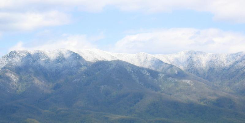
Post Hike Report: April 24 dawned, not with pre-summer as we expected, but with about an inch of snow in Asheville. Though this was surprising, we expected the snow-lovers (Stuart et. al) to show up in mass. However, there were only 5 of us at Westgate, and off we set for the Smokies to hike the Ramsey Cascades Trail. At the beginning there was about an inch of snow, but hardy yellow trillium and showy orchus were poking up to the great pleasure of the photographers in our group. There is about a 2000 ft elevation gain on this hike, and as we climbed higher the snow level increased. It was beautiful, and there are some enormous trees, chiefly Tulip Poplars on the route. We strung out, with Carroll K. setting a steady leading pace. Toward 12:30 the advance guard arrived at the falls which were spectacular with, by now, about 4-5 inches of snow around. After reuniting with the falls as lunch spot, we returned to the trailhead, encountering several hardly hikers coming up after us. You can't beat a hike with a reasonable amount of snow, because there's a special beauty, but who would have expected it on April 24? The rest of you CMC members who purport to be hikers really missed a great one! Tom
Half Day Sunday
HALF-DAY No. H0502-451 May 8 MST from Beaverdam Overlook to Sleepy Gap 1:30 PM Hike 5.5, Drive 35, Rated C-C, 960-ft. ascent Sherman Stambaugh 828-254-1736 P400 A moderate hike on the Mountains-to-Sea Trail, with a climb to Ferrin Knob, site of a former fire tower. Easy hiking to Chestnut Cove, then over Truckwheel Mountain to Sleepy Gap. Short car shuttle. Second meeting place: Ingles on NC 191 across from Biltmore Square Mall at 1:45 PM.
HALF DAY No. H0502-062 May 1 Daniel Ridge Loop 1:00 PM Hike 4, Drive 70, 1200-foot ascent, Rated C-B Pat Elias 828-687-1651 patelias@bellsouth.net P400 Note early start time. This pretty loop hike goes up along the Davidson River, then climbs up and over Daniel Ridge and ends at a spectacular 90-ft. waterfall. Second meeting place: Bi-Lo in Pisgah Forest at 1:30 PM.

Sunday, May 1, half day hike to Daniel Ridge changed due to weather-related, closed road
The alternate hike will meet at Westgate at 1:00 PM (second meeting place is Bi-Lo, Pisgah Forest, routes 280 and 276, at 1:35 PM. We will hike 5.3 miles at Cove Creek and Caney Bottom in the Pisgah Forest beyond the Fish Hatchery. After a pleasant walk through the woods, we will take our snack at picnic tables with a nice view of the surrounding hills. Our return walk will be along a stream with an interesting waterfall. There are several stream crossings on logs, some short ones without a railing. For further information, call Pat Elias, 828/687-1651 or email at patelias@bellsouth.net .
Post Hike Report: Well, our little friend pictured below didn't scare away the 15 hikers who walked the Cove Creek/Caney Bottom Loop. However, he also did not make his appearance today (I looked for him) as he did when I scouted the hike. We enjoyed a snack at picnic tables that service the Cove Creek camp ground -- which I understand will not be opening this year due to the September 2004 storm-damage conditions. Aside from beautiful hiking weather, multiple stream crossings, a couple of small, pretty waterfalls, and 15 exceptionally pleasant hikers, we saw a few clusters of dwarf iris, wood anemone, chick weed, and bluets. Pat
HALF-DAY No. H0502-450 April 24 Graveyard Fields 1:30 PM Hike 4, Drive 40, Rated C-C Heather and Barry Fletcher 828-299-4776 hmflet@aol.com P400 Enjoy a moderate loop hike to the spectacular waterfall with a side trip to the Yellowstone Prong falls. Second meeting place: Graveyard Fields Parking Lot at BRP Milepost 418.8 at 2:15 PM.
Post Hike Report: The planned half-day hike was to begin at mile 418.8 of the Blue Ridge Parkway and follow the Graveyard Ridge loop trail with a side trip to Yellowstone falls. The trail, when scouted the previous week, was in good condition. Unfortunately, a spring storm with snow and high winds blew in on Saturday. By Sunday, temperatures were not far above freezing even in Asheville and a winter storm watch was in effect. The BRP information service warned of road closures north of our destination. Hence, it was impossible to drive to the trail head. No hikers appeared at the first meeting place (Westgate). One person e-mailed us later to say that we should have notified everyone that the Parkway was closed. We responded with the BRP information number (828-298-0398) and an admonishment to call the hike leader if the weather is doubtful. We regret any inconvenience caused by the need to cancel this hike.
All Day Wednesday
WEDNESDAY No. W0502-310 May 4 Jones Gap: Rim of the Gap Loop 8:00 AM* Hike 7, Drive 80, 1800 ft. ascent, Rated B-A Jo Anderson, 828-693-7081 jobob@mehsi.com Starting at Jones Gap State Park (NOTE: $2 fee per person for park entry), we will hike up the Rim of the Gap Trail with views of the Gap as we ascend. On top, a loop up on to the ridge, then down the # 8 connector to the river. *Meeting places: Meet at Westgate at 8:00 AM to form car pools, and meet leader at east side of Ingles Parking lot at 8:40 AM. (take I-26 to exit 53, then turn right on upward Rd. go 1 mile to Ingles at US 176. Additional meeting place: Jones Gap parking lot at 9:00 am. Topos: Cleveland, Table Rock; also Mountain Bridge Wilderness map.
WEDNESDAY No. W0502-120 Apr. 27 Charlies’ Bunion-Kephart Prong 8:00 AM Hike 10.2, Drive 140, 1500 ft. ascent, Rated A-B Elisabeth Feil, 828-684-8719 hofeil@brinet.com 900M, SB6K? An outstanding rock outcrop along the AT, stunning views, and a great wildflower display are the highlights of the trip. Starting at Newfound Gap, we hike 4 miles to the Bunion, then along Dry Sluice Gap, Grassy Branch and Kephart Prong Trails down to US 441. (There is an optional side trip over Mt. Kephart (6000 ft) to The Jumpoff, which adds another 2 miles. We’ll make our decision when we get there.) This hike is moderate to strenuous about 1500 ft uphill and 2800 ft down. Car shuttle. Second meeting place: Quality Inn at Junction US 19 and US 276 in Maggie Valley at 8:40 am. Topos: Clingmans Dome, Mt Guyot, Smokemont; also Nat’l. Geographic GSMNP map
Post Hike Report: The weather report sounded good, if a bit chilly. But as our group of 16 persons approached the Smokies the clouds began to look ominous. And, sure enough, after initial sunshine there came squalls of tiny ice pebbles, and the biting wind did not help, especially for those who did not come adequately prepared. There was ice on the trail below Icewater Springs Shelter. As we descended into the valley conditions improved, and the flowers, although later than recent years, did not disappoint us. This is always a good hike with enough diversity to keep everyone interested. Elisabeth Feil
HikingNews....
_____________________________________________________________
FONTANA WEEKEND 2005
Two years ago, 50 CMCers' spent a relaxing September weekend at Fontana Village, NC, hiking nearby trails in the Smokies and enjoying a boat trip and tour of an abandoned town and the old Eagle Creek copper mine. We plan to schedule a similar trip this year. So set aside the weekend of Sept. 30 – Oct. 2 to join us. Additional information will be posted in the future in the E-Newsletter and in Let’s Go as plans develop. Please contact Bruce Bente at bbente@cytechusa.com for any questions or suggestions that you have about this trip.
Mast General Store Discount
Enjoy My Employee Discount for a Day I'm lucky to have you as a part of my circle of friends. Once a year, we get to share our employee discount with folks we know, so it is my pleasure to share mine with you. Here's your opportunity to get 25% OFF on up to four regularly-priced items on Sunday, May 15th. The discount can be used at any of our stores - Valle Crucis, Boone, Waynesville, Hendersonville, Asheville, and Greenville (SC) or at www.MastStoreOnline.com (the discount isn't available for phone orders). It can also be used at Mast General Store Candy and More in Downtown Blowing Rock. The coupon is good only on Sunday, May 15th, so I hope I've given you enough time to plan your trip to see us - if you can't make it, check out our online store for some great items. Click here for your Employee for a Day coupon and more information and details.