ALL DAY No. A0602-208 April 9
Buck Spring Gap – Little Pisgah Loop 8:30 AM* Hike 7, Drive 40, 2200 ft. ascent, Rated B-AA John Pawcio, 828-299-8126, jpawcio@tycovalves.com P400 *Note later start time. From Buck Spring Gap on the Blue Ridge Parkway we will descend the Little Pisgah Ridge Trail to Big Creek, then ascend to Laurel Mtn. Expect good early Spring views. Second Meeting Place: French Broad Overlook on BRP at 8:45 AM. Topo: Dunsmore Mtn.; also Nat’l. Geo. PRD map
ALL DAY No. A0602-355 April 16
AT: Devils Fork Gap to Carmen 8:00 AM Hike 11, Drive 95, 1900 ft. ascent, Rated A-A Mike Ellis, 828-301-4117, Michael.f.ellis@gmail.com This trip goes along nine of the most scenic miles on the AT. It features two shelters, including Jerry’s Cabin, a historic gravesite and beautiful views from atop Big Butt. We then go down Fork Ridge trail to Carmen. Car shuttle. Topos: Flag Pond, Greystone; also Nat’l. Geo. French Broad & Nolichucky Rivers map
HALF-DAY No. H0602-101 April 9
Laurel River Wildflower Stroll 1:00 PM*
Hike 6, Drive 60, 200-ft ascent, Rated B-C Jean Gard, 828-777-1814, jeangard@charter.net
*Note early start time. Leisurely paced in-and-out hike along Lower Big Laurel Creek to the site of Runion, an early 1900s logging and mining settlement. Over 250 plants have been identified along this trail, including five that are endangered. Long pants suggested (poison ivy sprouts early).
HALF-DAY No. H0602-345 April 16
Seven Gaps and Seven Knobs 1:00 PM* Hike 6.5, Drive 25, Rated B-C
Stuart English, 828-883-2447, stuengo@citcom.net
P400 *Note early start time. We should see many wild flowers on this up-and-down hike that begins at the intersection of the Bent Creek Gap Road and the BRP, follows a portion of the MST and then goes along the ridge and down the Laurel Branch Road. Short car shuttle. Second meeting place: Ingles across from Biltmore Square Mall at 1:15 PM.
WEDNESDAY NO. W0602-I Apr. 5 Leader’s Choice 8:00 AM Hike about 8, Drive not far, Rated B-B Kathie Giddings,
828-696-9808, kmgiddings@highstream.net
The leader promises to find an interesting moderate hike in the nearby area. Come out to enjoy the early spring weather and blooms. *Meet at Westgate at 8:00 AM to form carpools, and meet leader at the Bi-Lo parking lot in Pisgah Forest at 8:30 AM.
WEDNESDAY No. W0602-518 Apr. 12
Five Waterfalls in South Carolina 8:00 AM* Hike 6, Drive 200, 500 ft. ascent, Rated B-C Jack Fitzgerald, 828-685-2897, suejackfitz@bellsouth.net Visit five great waterfalls in SC: Spoonauger, King Creek, Yellow Branch, Issaqueena, Station Cove. All in and out hikes with 1-2 miles round trip for each. Long drive and long day but well worth it with waterfalls and spring flowers and maybe a visit to “Bob’s Place”. *Meet at Westgate at 8:00 AM to form car pools, and. meet leader at Cracker Barrel, exit 53 on I-26 at 8:30 AM.
WEDNESDAY No. W0602-519 NO. W0602-519 Apr. 19
Raven Cliff Falls, The Cathedral Rock, Dismal Trail Loop 8:00 AM* Hike 9, Drive 95, 2300 ft. ascent, Rated A-AA Ann Gleason,
828-859-9387 gleason.ann@gmail.com
Hike to 412 ft Raven Cliff falls in Caesar’s head state Park where we cross ther suspension bridge and descend 120 ft down “the cathedral”. We then cross Matthews creek on a cable crossing with a steep ascent up the Dismal Trail to a large rock outcropping with great view of the falls, then return to parking lot. *Meet at Westgate at 8:00 AM to form car pools, and meet leader at Bi-Lo Parking lot in Pisgah Forest at 8:30 AM. Additional meeting place: Raven Cliff Parking lot on US 276 at 9:00 AM. NOTE: $2 fee per person for park entry. Topo: Table Rock; also Mountain Bridge Wilderness map
SATURDAY No. A0601-224 March 25
Table Rock – Pinnacle Loop 8:00 AM Hike 10.8, Drive 120, 3200 ft. ascent, Rated A-AA+ Lenny Bernstein, 828-236-0192, lsberns@worldnet.att.net This is a great hike with good views, starting from the Nature Center parking lot at Table Rock St. Park. Our first objective will be Bald Rock near Pinnacle Mtn. with glorious views. Then after a climb to Pinnacle Mtn for lunch, we’ll walk the ridgeline to Table Rock with more great views, then down steeply to our cars. $2 parking fee. Additional meeting places: Cracker Barrel at exit 53 of I-26 at 8:30 AM (park at north end of parking lot near Upward Rd.), and Table Rock State Park (at Nature Center parking lot) at 9:15 AM. Topo: Table Rock
 It was another cool, cloudy day as six of us headed for The Pinnacle and Table Rock. We had the trail to ourselves for the first half of the hike, but once we passed Panther Gap and headed up Governor’s Rock to Table Rock, we met crowds of people, including two groups of more than a dozen. You need to take your trail breaks before Panther Gap on this hike.
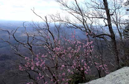
The early spring flowers were out, but other than bloodroot, none of us could identify any of them. There was a particularly impressive flowering tree alongside Bald Rock – let me know if you can identify it from Stuart English’s picture. There were also a number of trees with white flowers, which were probably pear trees, as well as small yellow flowers and purple flowers, but the group didn’t spend much time admiring them.
Since we had Matt Sowles, who lives close by with us, I found out many things about the hike that I hadn’t known before. The Pinnacle, at 3400 feet, is the highest mountain entirely, in South Carolina. Sassafras Mountain is the highest mountain in South Carolina, but since it is on the North Carolina border, part of it is outside South Carolina. At the Table Rock Overlook, the lower, round-top mountain to your right, is known as The Stool, and the waterfall just barely visible on your left is Slickum Falls. The lake in front of you is Table Rock Reservoir. We decided that the next time this hike is done, Matt ought to lead it. Lenny Bernstein
ALL DAY No. A0601-423 Mar. 26
Pilot Rock, Laurel Mtn., Slate Rock Creek Trails 8:00 AM Hike 10, Drive 90, 1600 ft. ascent, Rated A-A Ruth Hartzler, 828-251-0886 P400 We will hike up the Pilot Rock Trail, stopping to enjoy the views. Then we’ll turn downhill on the Laurel Mtn. Trail and a no-name trail to the Slate Rock Creek Trail, one of the gems of Pisgah Nat’l. Forest. Short car shuttle. Second meeting place: North Mills River Recreation Area parking lot at 8:30 AM, but call leader beforehand. Topo: Dunsmore Mtn.; also Nat’l. Geo. PRD map
 Pilot Rock/Slate Rock Creek
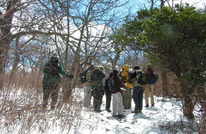
If I don’t say so myself, this hike was great! Seven hikers from Asheville joined nine at the North Mills parking area for a total of 16. Since Yellow Gap Road is narrow, with limited parking at the trailheads, some logistical organization was needed to set up the car shuttle. We left two cars at the Slate Rock Creek trailhead, then piled into four cars for the trip to the Pilot Rock Trailhead. We hiked 1500’ up the Pilot Rock Trail, stopping several times to enjoy sunny 180 degree views and to take off jackets. We stomped through a few small patches of snow, and snacked at the intersection with the connector trail. Snow conditions seemed clear enough to warrant an attempt to summit Little Bald Mountain. So we merrily continued up Pilot Rock Trail, heading for Little Bald. Immediately, dark clouds roiled overhead, icy winds knifed through our layers of clothing, and snow drifted almost to knee height. (Remember, the leader is short.) The valiant group pressed on. We summited Little Bald and took some photos in the snow. With lunchtime quickly approaching, we decided to avoid the north side of Little Bald with potentially deeper snow and retrace our steps back down to the connector. From there, we took the connector to the Laurel Mountain Trail for lunch in a little sunshine, out of the wind. We followed the ridgeline to Sassafras Gap, where we turned down the Noname trail, picking up Slate Rock Creek Trail from the right. Down Slate Rock Creek Trail, hiking conversation was accompanied by the gurgling and splashing of Slate Rock Creek to our right. After a brief snack break in open woods, we arrived at the shuttle cars.--Ruth
ALL DAY No. A0602-507 April 2
Little Paint Creek 8:00 AM* (strenuous) Hike 8-9, Drive 78, 1800 ft. ascent, Rated B-A Stuart Tauber, 828-254-0824, sdtauber@charter.net *Note time change to DST. Hikers must call leader before attempting this hike. From Allen Gap, we will climb south on the AT to Deep Gap to connect with Little Paint Creek Trail (#11). We will proceed along, through and across the creek under Buzzard Roost Ridge several times to reach FS 31B and then Paint Creek Trail (#10), fording the creek several times, to finally reach Little Paint Creek campground. The creek crossings are challenging as is the trail. 10-mile car shuttle. Topo: Hot Springs; also Nat’l. Geo. French Broad & Nolichucky Rivers map
Little Paint Creek Hike
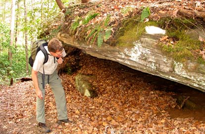
Seven hikers assembled at the trailhead of the AT in Allen gap after having placed two cars in the parking area at Little Paint Creek Campground. After climbing the AT to Deep Gap, we proceeded down the Little Paint Creek Trail through a lush and magnificent Cove to find the creek and begin a series of creek crossings finally to reach the end of Forest Service Road 31B. We circumvented the previously destroyed bridge and forded the creek four times to reach the newly constructed bridge. By this time the hikers were so energized and proud of their creek crossings skills that they chose to ford the creek one more time. The third section of the hike climbed high above the now boisterous and rapid creek before finally returning once more to the creekside. We climbed out of the Cove and descended into the campground where we inspected some of the relics of the logging railroad. The trip back to Asheville was made more pleasant by a stop at the coffeehouse at the junction of 25/70 and NC 208.
Spring flowers were abundant and we saw examples of the following:
Halbeard’s yellow violet,
White, purple, and Birdfoot violets,
Trailing arbutus,
Chickweed, common and giant,
Bishops cap,
Pussy toes plantain,
Toothwort,
Ragwort,
Bloodroot,
Polygala,
Service Berry trees. Stuart Tauber
ALL DAY No. A0602-209 April 2
Buckwheat Knob – Coontree Loop 9:00 AM* (moderate) Hike 8, Drive 67, 1900 ft. ascent, Rated B-A Les Love, 828-658-1489, lesrlove@charter.net P400 *Note later start time and time change to DST.
From the trailhead at Coontree Picnic area, we’ll climb along beautiful Coontree Creek through open
forest up to Bennett Gap and on to Buckwheat Knob for lunch, then return via the other segment of the Coontree loop.
A moderate woodland hike with exceptional views from the ridgeline. Second meeting place: Coontree Picnic area at 9:40 AM.
Topo: Shining Rock; also Nat’l. Geo. PRD map
19 people enjoyed a beautiful spring day with highs in the 70s, starting at the Coontree picnic area at 10:00 due to the time change. Great views of Looking Glass Rock at Saddle Gap and lunch at Buckwheat Knob. 8 hikers went on to Club Gap during lunch to complete the Bennet Gap trail. Back at Westgate at 5:00. Les
All-day hikes submitted by Bruce Bente 692-0116, bbente@cytechusa.com . Driving distance is round-trip from Asheville. All Saturday and Sunday hikes assemble at Westgate Shopping Center near I-240 UNLESS OTHERWISE NOTED.
HALF-DAY No. H0601-501 March 26
Hickory Nut Gap to Ferguson Peak 1:30 PM Hike 5, Drive 30, Rated C-C Jane and Lew Blodgett, 828-274-7863
An in-and-out hike from US 74 in Fairview. A fairly steep climb is rewarded with excellent views to the west.
HALF-DAY No. H0601-171 Apr. 2
Cat Gap Loop 1:30 PM* Hike 5, Drive 40, 1100 ft. Ascent, Rated C-B Barbara Rathbone-Shoaf, 828-667-8684 or 336-769-1188, bpsss354@netzero.com or barbararathboneshoaf@gmail.com P400
This is a moderate loop hike on the Cat Gap Loop Trail. *Second meeting place, Fish Hatchery parking lot at 2:10 PM.
 Sixteen hikers climbed to Cat Gap and returned by "the other side of the mountain" on Sunday afternoon. Rain threatened as the hikers started on the Horse Cove Trail but quickly evaporated into a glorious afternoon. The 1100 foot climb at the beginning of the hike gave everyone a good workout and accelerated respiration. Three hikers were experiencing their very first hike with the CMC. They were enthusiastic and very welcome in the group. At the conclusion of the hike, everyone was anticipating the first ice cream "of the season" at Dolly's. Barbara.
WEDNESDAY No. W0601-113 Mar. 22
Cold Mountain from Camp Daniel Boone 8:00 AM Hike 11, Drive 70, Rated A-AA Tom Sanders, 828-252-6327,
tomary2@charter.net SB6K. Here is your chance to climb the mountain immortalized
by Charles Frazier, as well as to enjoy outstanding views if the weather permits. From Camp Daniel Boone we will ascend 2500 ft.
to the summit at 6030 ft., returning by the same route. Strenuous, so you should be in good shape. Wilderness area, limit 10,
so call leader for reservation. Second meeting place: trailhead above Camp Daniel Boone. Topos: Waynesville, Cruso
WEDNESDAY No. W0601-345 Mar. 29
7 Gaps and 7 Knobs 9:30 AM Hike 6.5, drive 25, rated B-B Paula Robbins, 828-281-3253(before 9pm),
paularww@bellsouth.net Hike begins at Bent Creek Gap near the Blue Ridge Parkway.
First mile is on the MST, last mile is on Laurel Branch Rd. off the Bent Creek Gap Rd. Maybe early wildflowers will be seen.
Second meeting place: Ingles parking lot across from Biltmore Square Mall on NC 191 south of I-26 at 9:45 AM.
Wednesday Hikes are submitted by Paula McNabb, 828- 274-0057 gcmcnabb@charter.net and Ann Gleason, 828-859-9387, cowbonetail@yahoo.com . The meeting place for each hike will be designated by the hike leader and will appear in the hike description. Driving mileage will be listed, round trip, from the first designated meeting place.