|
Looking Ahead
All Day Saturday & Sunday
ALL DAY NO. A0801-592 Feb. 17
ALT – Butter Gap - Long Branch Loop 8:00 AM*
Hike 9, Drive 80, 1500 ft. ascent, Rated B-B
Stu English, 828-883-2447, stuengo@citcom.net
P400 *Meet at Westgate at 8:00 AM to form carpools, and meet leader at the side parking lot of the Pisgah Forest Bi-Lo at 8:30 AM. This new CMC hike will start at Gloucester Gap and follow the Art Loeb Trail over Rich Mtn. to Butter Gap. At the gap, we’ll turn downhill onto the Butter Gap Trail, then the Long Branch Trail and Cemetery Loop past the McCall Cemetery. There will be a short side trip to a beautiful, but rarely visited waterfall.We’ll finish with a short road walk back to the trailhead. Topo: Shining Rock; also Nat’l. Geo. PRD map
#780SATURDAY NO. A0801-593 Feb. 23
AT: Lemon Gap – Bluff Mtn. 8:00 AM
Hike 7.6, Drive 120, 1900 ft. ascent, Rated B-AA
Don Walton, 828-654-9904, donwalton@bellsouth.net
This AT hike takes us past the historic Walnut Mtn. shelter (built in 1938 by CCC) and recently cleared bald area, through Kale Gap and to the summit of Bluff Mtn. We may also bushwhack to the real peak of Bluff Mtn. Second meeting place: Pilot Truck Stop off I-40 at exit 24 at 8:30 AM Topo: Lemon Gap
ALL DAY NO. A0801-420 Feb. 24
AT: Allen Gap to Tanyard Gap 8:30 AM*
Hike 8.8, Drive 80, 2100 ft. ascent, Rated B-AA
Tish Desjardins, 828-656-2191, desraylet@aol.com
*Note later start time. Meet at Westgate at 8:30 AM to form carpools, and meet leader at parking lot on US 25 at intersection with NC 208 at 9:10 AM. Great views from Rich Mtn. tower, a visit to Spring Mtn. shelter and one of the prettiest sections of the AT in our area highlight this pleasant winter hike. Car shuttle. Topo: Hot Springs
Half Day Sunday
HALF-DAY NO. H0801-591 Feb. 17
Bent Creek Loop #10 1:00 PM*
Hike 5, Drive 20, 800 ft. ascent, Rated C-C
Nonmembers, call leader, Marcia Bromberg, 828-505-0471, mwbromberg@yahoo.com
P400 *Note early start time. A pleasant winter walk along lesser-hiked trails and roads in Bent Creek, including Sidehill Connector, Lower Sidehill Trail, South Ridge Road, Chestnut Cove and Explorer.
HALF-DAY NO. H0801-225 Feb. 24
Ingles Field Gap via Boyd Branch and Little Hickory Top Trails 1:00 PM*
Hike 6, Drive 20, Rated B-C
Nonmembers, call leader, Joe Burchfield, 828-398-8413, burchfield@niu.edu
P400 *Note early start time. A moderate loop hike up to Stradley Mountain following several of the trails in the Bent Creek Experimental Forest. Second meeting place: Ingles parking lot across from Biltmore Square Mall on NC 191 south of I-26 at 1:20 PM.
All Day Wednesday
WEDNESDAY NO W0801-428 Feb. 20
Cane River Gap to Little Butt 8:30 AM
Hike 7, Drive 50, 2200 ft. ascent, Rated B-AA
Ruben Marshall, 828-299-1497, cmcrm08@yahoo.com
This hike begins with a 1200 ft. ascent to the ridgeline, then continues along the top of the ridge with a few gradual ups-and-downs. After Big Butt, we’ll follow the narrow ridgeline with good views to our lunch spot at Little Butt, which has a great view of the Black Mtns. range across the valley. Return via the same route. Topo: Mt. Mitchell; also USFS Big Ivy map
WEDNESDAY NO W0801-599 Feb. 27
Daniel Ridge-Caney Bottom – Cove Creek Falls Loop 8:30 AM*
Hike 10, Drive 80, 1000 ft. ascent, Rated A-B
Stuart English, 828-883-2447, stuengo@citcom.net
P400 *Meet at Westgate at 8:30 AM to form car pools, and meet leader at Pisgah Forest Ranger Station at 9:05 AM. We’ll start with the 4-mile Daniel Ridge Loop, ending at Toms Springs Falls, a 100 foot falls. From these falls, we’ll follow an old FS road, go down a perfectly good but unmapped trail to Caney Bottom Trail. Here we’ll loop around it to Cove Creek Trail and 60 foot Cove Creek Falls, then back to Caney Bottom Loop and eventually back to our cars on Davidson River Road (FS 475). Topo: Shining Rock; also Nat’l. Geo. PRD map #780
Looking Back......
All Day Saturday & Sunday
ALL DAY NO. A0801-502 Feb. 3
Deep Creek – Sunkota Ridge loop 7:30 AM*
(strenuous)
Hike 13, Drive 135, 2000 ft. ascent, Rated AA-A
Charlie Ferguson, 828-333-5165, ccf108@gmail.com
900M *Note early start time. We will hike alongside Deep Creek, one of the beautiful streams on the east side of the Smokies, and then climb up to and down Sunkota Ridge, which will have good winter views. Second meeting place: Rest area beyond Waynesville on US 23/74 at 8:00 AM. Topos: Bryson City, Clingman’s Dome; also Nat’l. Geo. GSMNP map #229
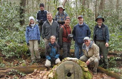 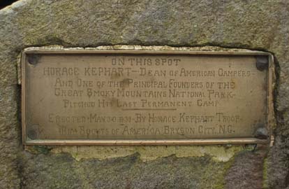
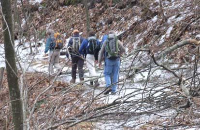
Ten hikers went on this longish hike. We arrived at the Camp Creek Trailhead about 9:00. The sun was out and the temperature was cool. We hiked on the trail along Camp Creek, passing Tom Falls and two campsites. Six miles and a thousand feet of climbing took us to the junction of that trail and the MST (Martin's Gap trail at that point). For lunch we stopped at campsite 57, Bryson Place, where Horuce Kephart had his last permanent campsite. The Bryson City Boy Scouts placed a memorial there in 1931 which we looked at before leaving for Martin's Gap. A thousand foot climb over 1.5 miles provide a good workout for everyone. We left the MST behind and hiked south on Sunkota Ridge to the 3,860 foot high point an unnamed peak a little bit off the trail. On the way back down, the sun gradually hid behind a high layer of clouds, but the temperature continued to rise. There was no snow or ice on the trails. The thick cover of dry leaves still made short parts of the trail slippery. At the end of the Sunkota Ridge trail we turned left to go down to the Indian Creek Trail, a wide road.
That took us past Indian Creek Falls, which we visited for awhile.
Then we were back at Camp Creek and returned to the trail head.
It started to rain when we were about a hundred yards from our cars. Other than that we had great hiking weather.
Seven of us stopped at Bogarts, in Waynesville, for supper.
Our first choice of pizza at Nick and Nate's was preempted by the Super Bowl. Charlie. Photos by Charlie Ferguson
ALL DAY NO. A0801-106 Feb. 3
Ferrin Knob via Spencer Branch and Bad Fork 8:30 AM*
(moderate)
Hike 9, Drive 42, 1550 ft. ascent, Rated B-A
Ruben Marshall, 828-299-1497, cmcrm08@yahoo.com
P400.*Note later starting time. This moderate jaunt in the North Mills River area is a loop hike that starts at the Trace Ridge trailhead and climbs via Spencer Branch trail past the Hendersonville Reservoir to our lunch spot atop 4064 ft. Ferrin Knob, the former site of a fire tower. We will return via the Bad Fork trail. Second meeting place: Trace Ridge Trailhead at 9:00 AM. Topo: Dunsmore Mtn.; also Natl. Geo. PRD map #780
As a hike leader, I scout a hike at least once,
preferably twice. For the first scouting, thanks to
the generosity of Bruce Bente, who put together a
knowledgeable crew, I was able to cover the turns and
twists of the trail with no difficulty.
Three days before the hike, one of those crew members,
Ashok Kudva, volunteered to return and search out the
last mile or two so that I could eliminate the short
hike down a car road. And because there was an ice
storm two days before this Sunday hike, I redid the
entire hike the day before the hike, just in case the
ice and blowdown had made the trail impassable at the
higher elevations. Because there was an unsafe amount
of ice combined with blowdown and a narrow path, I
decided to change the highest part of the trip by not
going higher than the Blue Ridge Parkway (eliminating
about a mile of climbing). The Sunday group was
understanding about the change based on hiker safety.
However, the warm Sunday temperature had melted most
of the ice; after reaching the Parkway, two volunteers
reported back that the ice was mostly gone. So, I
changed back to doing the whole hike with the proviso
that should there be unsafe conditions at any point,
we would turn around and come back via the Parkway.
The group was very understanding and willing to go on
even with my proviso. Though most of the ice was
gone, we still had to negotiate around and under and
over at least 3 dozen blowdowns.
It was a gorgeous day to enjoy the beauty of North
Carolina. It was pleasant to hear the appreciative
comments about knowing the trail, and putting hiker
safety first. Ruben. Photos by Ashok Kudval
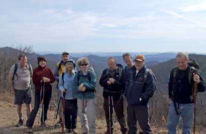
ALL DAY NO. A0801-505 Feb. 10
The Other Cold Mtn. 8:00 AM*
Hike 8, Drive 120, 2200 ft. ascent, Rated B-AA
Dave Wetmore, 828-884-7296, dwetmore@citcom.net
You may have climbed the Cold Mountain above Waynesville, but have you climbed the Cold Mountain above Panthertown Valley? This is a pleasant hike with good views of the Pisgah Ledge and at our lunch spot down into Panthertown Valley. *Meet at Westgate at 8:00 AM to form carpools, and meet leader at Bi-Lo side parking lot in Pisgah Forest at 8:30 AM. Topo: Big Ridge; also Panthertown Trail Map
 When we met at Bi-Lo in Brevard we stood around joking about the
reliability of weather forecasts, strong winds having been predicted. At
lunch near High Bethel we crouched in the laurel, trying to keep our packs
and smaller hikers from being blown away.
When we met at Bi-Lo in Brevard we stood around joking about the
reliability of weather forecasts, strong winds having been predicted. At
lunch near High Bethel we crouched in the laurel, trying to keep our packs
and smaller hikers from being blown away.
Other than the high winds which started right after we got to the trailhead,
it was an enjoyable trip for the nine of us. The clear skies allowed great
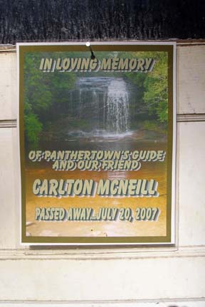
views both of the Pisgah Ledge and the Nantahala area. There was one sad note. On the way out we noticed a sign on Carleton
McNeill's house saying he had died last summer. Anyone who has hiked much in
Panthertown will remember Carleton for the two friendly dogs that always
heralded his approach, his affability and his willingness to share knowledge.
He was a good host in his valley. Dave. Photo by Bruce Bente.
Half Day Sunday
HALF-DAY NO. H0801-499 Feb. 3
French Broad River Greenway 1:30 PM
Hike 4, Drive 10, Rated C-C
Paula Robbins, 828-281-3253, paularww@bellsouth.net
Asheville’s Greenway System now provides several opportunities for city walking. The leader, a former member of the Greenway Commission, will describe plans for extending this riverfront trail and other existing and planned greenways within the City.
Thirty-three folks,
including several newcomers, enjoyed a four-mile, two-way walk along the French Broad River
on the Carrier Park and French Broad River Greenways off Amboy Road in 63-degree weather.
Paula Robbins, hike leader, explained plans for extension of the greenway south to the Hominy Creek Park
and north to the West Asheville/RiverLink Bridge as well as RiverLink’s
master plan for development along the Wilma Dykeman Riverway, including future greenways. Paula.
HALF-DAY NO. H0801-278 Feb. 10
Kitsuma Peak 12:30 PM*
Hike 6, Drive 60, 2000 feet ascent, Rated B-A
Nonmembers, call leader, Renate Rikkers, 828-298-9988, rerikkers@aol.com
*Note early start time. Meet at Westgate to form carpools, and meet hike leader at parking lot adjacent to McDonald’s in Black Mountain off exit 64 of I-40 at 12:50 PM. This trail from the Old Fort picnic ground to Kitsuma Peak follows Youngs Ridge and is a steady and demanding climb with an elevation gain of 2000 ft. before descending to Ridgecrest - a good winter hike to keep warm! Enjoy long range views of Greybeard, Green Knob and the Mt. Mitchell region with the Swannanoa River Valley below. Car spotting at Ridgecrest for return shuttle.
Eleven intrepid folks in high spirits braved the high winds that developed late morning and continued throughout this 6-mile hike from the Old Fort picnic grounds to Ridgecrest, a steady climb along Young's Ridge that kept our hearts pumping and our bodies warm. With efficient car shuttling, we were on the trail at 1:30 and kept up a steady pace that everyone agreed to and was comfortable with. This is an excellent winter hike,
demanding steady energy output for the 2000' ascent to the highest point of the ridge - with rewarding long distance views along the way. The high winds kept our rest stops brief, and we completed the hike in a little over 3 hours, picked up the cars at the starting point, and had everyone on their way home by 5:15 PM.
We enjoyed a somewhat international group, with a guest hiker from London, an AMC member from Argentina, and a German hike leader - no problems getting along!
Renate Rikkers
Wednesday
WEDNESDAY NO W0801-594 Feb. 6
KagleStone Ramble 8:00 AM
Hike 10.4, Drive 80, 2100 ft. ascent, Rated A-AA
Tom Bindrim & Joan Lemire, 828-273-3880,
*Meet at Westgate at 8:00 AM to form carpools, and meet leaders at Pisgah Forest Bi-Lo side parking lot at 8:30 AM. This will be a moderately paced hike (expect late return) in a Figure 8 loop that will take us to the tops of two more granitic bubbles that together with their more famous companions, comprise our local pluton. Some off-trail hiking, even bushwhacking. Topo: Shining Rock and Rosman. Nat'l Geo. PRD trail map #780 marginally useful
With severe weather and thunderboomers and 90% chance of rain forecast and raining already, we were very thankful that no all-weather crazies showed up for the Wed 2/6 KagleStone Ramble. Bushwhacking through that stuff is a good way to shred an expensive set of rain gear. One new member did show tentatively at Westgate but his heart was no more in it than ours. He called us at 8:15 to get told we'd cancelled out. No one else was at Westgate or Pisgah Forest anyway, so we went home and did rainy day plan B stuff. Next morning we had 27.9 mm in the rain gauge. We're hoping for better on Sun 3/2. It's really a neat hike. Tom & Joan
WEDNESDAY NO W0801-304 Feb. 13
Shut-In Trail to Garenflo Gap to Hot Springs 8:30 AM
Hike 8.6, Drive 80, 2100 ft. ascent, Rated B-AA
Jay Bretz, 828-658-1220, williambretz1220@msn.com
We’ll start by hiking up the East Fork Shut-in Creek trail to the AT, doing 16 stream crossings and then a pleasant AT hike down Deer Park Mtn. 5 mile car shuttle. Topo: Lemon Gap, Spring Creek, Hot Springs; also Nat’l. Geo. French Broad & Nolichucky Rivers map #782
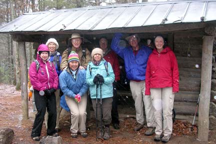 Eight optimistic hikers met me at Westgate on an overcast raining morning for a romp in the woods. We all agreed to take our chances with the weather to pursue fellowship and fun in the woods outside of Hot Springs. I did though cancel the section of the trail with the 16 creek crossings due the recent rains and discovering on my Friday scouting that the creeks were full. Thus we started our hike at Garenflo Gap. After driving through some showers on our way to Hot Springs, we were pleasantly surprised at the trailhead to find a gentle winter snow shower. We proceeded with the hike stopping at the Deerpark shelter for lunch(see picture). After lunch the temperature began to drop precipitously but we remained warm with constant movement. Eight optimistic hikers met me at Westgate on an overcast raining morning for a romp in the woods. We all agreed to take our chances with the weather to pursue fellowship and fun in the woods outside of Hot Springs. I did though cancel the section of the trail with the 16 creek crossings due the recent rains and discovering on my Friday scouting that the creeks were full. Thus we started our hike at Garenflo Gap. After driving through some showers on our way to Hot Springs, we were pleasantly surprised at the trailhead to find a gentle winter snow shower. We proceeded with the hike stopping at the Deerpark shelter for lunch(see picture). After lunch the temperature began to drop precipitously but we remained warm with constant movement.
We arrived safely in Hot Springs and immediately visited the Smokey Mountain Diner and warmed up with coffee, tea, hot chocolate and warm homemade pies and peach cobbler. A few of us ventured to the Hot Spring Spa for the Hot tubs while the rest of the group headed back to Asheville. We all agreed that the snow laden scenery was enjoyable and that the day turned out to be a successful romp in the woods with friends.
Optimistically
Jay Bretz. Photo by Lee Silver.
All-day hikes submitted by Bruce Bente 692-0116, bbente@bellsouth.net . Driving distance is round-trip from Asheville. All Saturday and Sunday hikes assemble at Westgate Shopping Center near I-240 UNLESS OTHERWISE NOTED.
Half Day hikes submitted by Paula Robbins 828-687-1651 paularww@bellsouth.net and Lucy Prim 828-693-6580 lucette32@mchsi.com.
Wednesday Hikes are submitted by Charlie Ferguson, 828-398-0213 ccf108@gmail.com and Ann Gleason, 828-859-9387,
gleason.ann@gmail.com .
The meeting place for each hike will be designated by the hike leader and will appear in the hike description.
Driving mileage will be listed, round trip, from the first designated meeting place.
Leaders: Mail please mail your sign-up sheets. Meet at Westgate unless otherwise noted. |
 CMC Bi-Weekly Hike News