ALL DAY NO. A0803-374 Sept. 14
MST: NC 221 to Bald Knob 8:00 AM
Hike 10, Drive 80, 2500 ft. ascent, Rated A-AA
Michael & Kathy Cornn, 828-698-3672, mcornn@aol.com
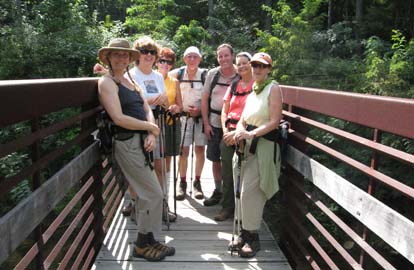
We’ll go north of our usual hiking area to hike the MST north from NC 221 to the North Fork of the Catawba River.
After crossing the new MST bridge over the river, we’ll hike north to the summit of Bald Knob,
and return via the same route. Second meeting place: Parking lot adjacent to McDonalds at Exit 64 of I-40 at 8:20 AM
. Topo: Little Switzerland
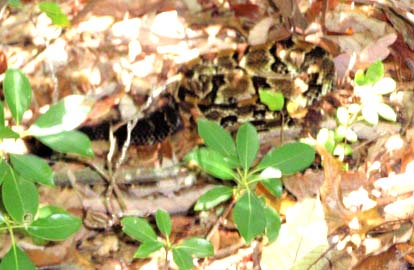
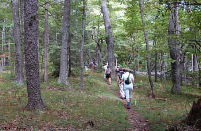
There were no yellow jacket sightings as had been common in recent hikes, although Kathleen Hudson did get bit by an unknown creature that she did not call a sting. Recent rains had nurtured and given birth to grotesque brown fungus along the trail. But the most intense encounter of the hike was when Heidi Saugen exclaimed “snake!” Heidi was the third in line on the hike. After identifying exactly where the snake was, we discovered a coiled rattlesnake on the trail that co-leaders Michael and Kathy had just walked over. Kathy also wielded walking poles - poking the ground like shishkabob skewers looking for meat. How we managed not to step or poke the creature was the second most amazing part of the trip. After finding a five-foot plus long stick, Michael carefully lifted and relocated the reptile that rattled its protest.
The others soon arrived and got to view the snake from a distance. Pictures were taken, and heart rates slowed. Within 20 feet of the encounter, we came upon the side trail from the Mountains-to-Sea Trail to the lunch spot that overlooks Lake James and Linville Gorge, one of the most spectacular views in the area, the most amazing part of the trip. The hike down was uneventful, but breezes relieved our descent and Ghiradelli dark chocolate brownies provided by the hike leaders further eased anxiety and fatigue. We resolved from the hike to learn more about snake bite treatment and to suggest that this hike be done later in the season - possibly October when hopefully temperatures would be lower. Kathy. Left photo by Ruth Hartzler, right photo by Carroll Koepplinger.
ALL DAY NO. A0803-337 Sept. 21
Shining Rock from Black Balsam *8:30 AM
Hike 11, Drive 65, 1500 ft. ascent, Rated A-A
Bob Hysko, 828-645-4626, rhysko@yahoo.com
SB6K, P400 *Note later starting time. We will take the Art Loeb Trail from FS 816 to Shining Rock (6040 ft.), climbing Black Balsam (6214 ft.), Tennent Mtn. (6040 ft.) and Grassy Cove Top (6040 ft.) along the way. This will be your chance to bag four SB6K peaks while enjoying beautiful views covering the area from Pilot Mtn. to Cold Mtn. We’ll return via the Ivestor Gap Trail to get a different perspective on the same area. Wilderness area hike limited to 10 people. Please contact hike leader to reserve your place. Second meeting place: BRP Cold Mtn. Overlook at 9:10 AM. Topos: Shining Rock, Sam Knob; also Natl. Geo. PRD map #780
 Another great day for hiking in the mountains of WNC!
With clear skies and cool temps. we all put on an extra layer leaving the parking lot by Black Balsam at 9:40 am. We headed up the access to the Art Loeb Trail. It soon warmed up and the extras were shed as we proceeded towards Tennent Mtn. on our way to Shining Rock. This could have been billed as a blueberry hike. There were quite a few blueberries along the trail which were pretty much in there prime. This was the cause of the extended time it took to get to the top of Tennent Mtn. All along the way there were numerous delays involving blueberries. If blueberries don’t slow down a hike nothing will!
Another great day for hiking in the mountains of WNC!
With clear skies and cool temps. we all put on an extra layer leaving the parking lot by Black Balsam at 9:40 am. We headed up the access to the Art Loeb Trail. It soon warmed up and the extras were shed as we proceeded towards Tennent Mtn. on our way to Shining Rock. This could have been billed as a blueberry hike. There were quite a few blueberries along the trail which were pretty much in there prime. This was the cause of the extended time it took to get to the top of Tennent Mtn. All along the way there were numerous delays involving blueberries. If blueberries don’t slow down a hike nothing will!
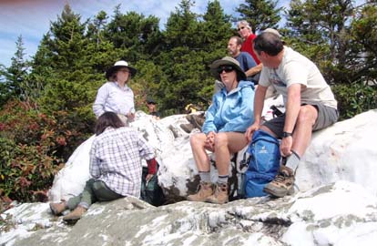
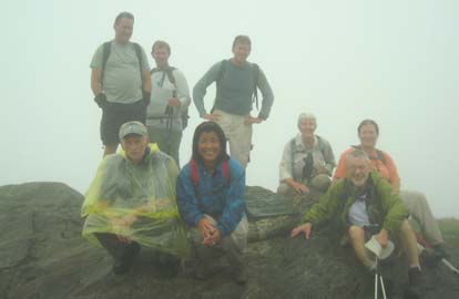
After toping off Grassy Cove we had lunch on Shining Rock. After reluctantly leaving the leisurely and relaxed lunch time we then proceeded down the Ivestor Gap Trail and arriving back at the parking lot a little before 4:00 pm. We were rewarded with another day of fantastic long range views. We all proceeded to have dinner at the Pisgah Inn where we helped celebrate Jackie’s 60th birthday! A rousing “Happy Birthday” and a large piece of chocolate cake with candle and an inspiring song by the waiter ended the very pleasant day!
Filling in as the Hike Leader, who had a problem with his knee, take care of it Bob! Carroll. Photo by Carroll Koepplinger
Half Day Sunday
HALF-DAY No. H0803-407 Sept. 14
Dill Falls *12:30 PM
Hike 4.1, Drive 85, Rated C-C
Nonmembers, call leader, Bonnie Allen, 828-645-0357
P400 *Note early start time. We will hike to Dill Falls, a magnificent 70 ft. waterfall, then hike up the west side of Tanasee Creek from the point where Charles Creek Road crosses the creek. There will be two stream crossings that can be done without removing boots if the water level is low. Second Meeting Place: Pisgah Forest Bi-Lo (intersection of NC 280 & US 64) side parking lot at 1:00 PM.
HALF-DAY NO. H0803-533 Sept. 21
Looking Glass Overlook to Wagon Road Gap on the MST *1:00 PM
Drive 70, Hike 5, 1500 ft. Ascent, Rated C-A
Nonmembers, call leader, Bruce Bente, 828-692-0116, bbente@bellsouth.net
P400 *Note earlier start time. Meet at Westgate at 1:00 PM to form carpools, and meet leader at BRP Wagon Road Gap Overlook (M.P. 412) at 1:40 PM. Although this hike is only 5 miles in length, please note that it will ascend a total of 1500 ft. It features great views from Green Knob as a payoff for the climb. Short car shuttle. Possible supper afterwards at Pisgah Inn.
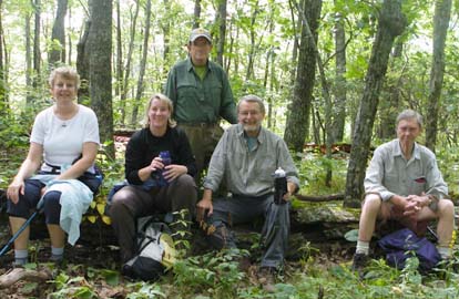
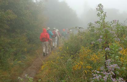
Fourteen people enjoyed this half-day hike on the MST in cool weather. A surprise to the leader was that only six of the hikers were regular CMC hikers, giving us the opportunity to welcome a number of new hikers. People came from far and wide for this hike, including NJ, Virginia and Florida and even one hiker from Mexico City.
This portion of the MST is very pleasant, going through open woods with a number of ups and downs on various hills and numerous BRP crossings. The final climb up Green Knob was challenging to some of the hikers but everyone made it in fine shape and proud of themselves for having done it.
Supper for five hikers was at Ruby Tuesday's on Airport Rd. Their great salad bar was enjoyed by all. Bruce. Photo on left by Ashok Kudva, on right by Ted Connors.
All Day Wednesday
WEDNESDAY NO W0803-242 Sep. 17
Sam Knob-Devils Courthouse *8:30 AM
(moderate)
Hike 8.5, Drive 75, 1500 ft. ascent, Rated B-B
Ruth Hartzler, 828-251-0886, ruthmtn@charter.net
SB6K, P400 From FS 816 we will ascend Sam Knob (6040 ft.) with its 360 degree views, then hike though high meadows on the Flat Laurel and Little Sam Trails and the MST via Devils Courthouse (with its great views). We then return via the MST across FS 816 and up to the summit of Black Balsam (6214 ft.), then down to our cars. Note: Ask the leader about options which can reduce the distance and ascent for this hike. Second Meeting Place: Cold Mtn. Overlook on BRP at 9:10 AM. Topo: Sam Knob; also Nat’l. Geo. PRD map #780
 No report. Photo by Ted Connors.
WEDNESDAY NO W0803-337 Sept. 17 (rescheduled from Aug 27)
Shining Rock from Black Balsam *8:30 AM (difficult)
Hike 11, Drive 65, 1500 ft. ascent, Rated A-A
Charlie Ferguson, 828-333-5165, ccf108@gmail.com
SB6K, P400 We will take the Art Loeb Trail from FS 816 to Shining Rock (6040’), climbing Black Balsam (6214’), Tennent Mtn. (6040’) and Grassy Cove Top (6040’) along the way. This will be your chance to bag four SB6K peaks while enjoying beautiful views covering the area from Pilot Mtn. to Cold Mtn. We’ll return via the Ivestor Gap Trail to get a different perspective on the same area. *Wilderness area hike limited to 10 people. Please contact hike leader to reserve your place. Second Meeting Place: BRP Cold Mtn. overlook at 9:10 AM. Topo: Shining Rock, Sam Knob; also Natl. Geo. PRD map #780. (This hike is also being done on Sunday Sept 21).
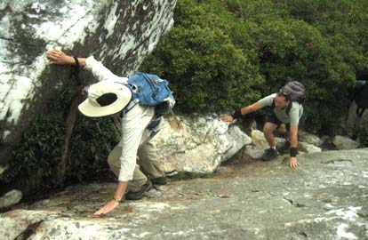
Nine strong hikers went on this 10.4 mile hike to Shining Rock and three other over 6000 foot peaks. We started at the point where the Art Loeb Trail crosses Rt 816 near Black Balsam and made the easy ascent to Black Balsam. Part way up we passed the junction where a new trail comes up from the Sam Knob parking lot. We were rewarded with a spectacular view of the inside of a dense fat layer of cloud. For those with really good infra-red vision, the nearby peaks were identified including the white quartzite of Shining Rock three miles to the north. This was one person's first visit to 6214 foot Black Balsam. Most of the trail to Shining Rock is pretty eroded and rocky. The rocks and roots were wet and often slippery. A half hour easy descent and ascent to 6050 foot Tennant Mountain and hikers began to get really excited about the CMC's SB6K (40 peaks over 6000 foot) challenge. Tennant Mountain provided another 360 degree fabulous view of the insides of a cloud. Another easy descent to Ivestor Gap and we were reminded of the yearly Labor Day gathering of the Inman clan of "Cold Mountain" fame. As we entered the wilderness area and ascended to 6045 feet Grassy Cove Top, our blueberry picking began in earnest. A couple of blueberry pickers were so distracted that they couldn't bring themselves to get to the top. We hiked down to the nice open grassy area at Flower Gap and had a leisurely lunch. We hiked to Shining Rock Gap which is where the Art Loeb Trail goes off to the left and continues north to Cold Mountain. We went straight continuing on the trail (not on the maps) that goes to the top of Shining Rock.
We stopped to look at the main quartzite outcrop and were told about how it formed. 100s of millions of years ago the original rocks, many of which contained crystalline quartz, eroded forming a mixture of quartz sand, feldspar sand or dust and small pieces of mica. These fine particles were washed down stream where they formed sediments. Sometimes the sediments were a mixture which eventually formed much of the rock of the Appalachian Mountains. Sometimes conditions were good for the quartz sand to concentrate and form layers by itself. These layers would eventually compress and form sandstone. Later after being subjected to very high pressures and temperatures the sandstone would fuse into the white quartzite that we see in thin layers in a lot of the rock that we see in these mountains. Shining Rock is a very, very thick layer of quartzite that has resisted the erosion that has worn down the softer rocks around it, making itself the king of this mountain.
After a little hand over foot climbing on the quartzite boulders we continued up to the very top where there were two jumbles of quartzite competing to be the 6010 foot king. The trail passed by both of them. There was an unscouted overgrown manway, down from the summit, that others had hiked before. We took that expecting to follow the same route. It was steep and rough. It started to veer north toward Cold Mountain, which we weren't interested in at this time. We noticed, on a map, that this manway was close to the Art Loeb Trail between Shining Rock and Cold Mountain, so we bushwhacked about 100 feet down to it. This shortened the hike by about 1/3 mile. The rest of the hike was a flat walk back to Ivestor Gap and then to the Sam Knob parking lot on the Ivestor Gap Trail. A half mile walk on 816 got us back to the cars at the Art Loeb Trailhead. Charlie. Photos by Charlie Ferguson.
WEDNESDAY NO W0803-250 Sept. 24
Douglas Falls – Locust Ridge Circuit 8:00 AM
Hike 11, Drive 60, 2000 ft. ascent, Rated A-A
Bruce Bente, 828-692-0116, bbente@bellsouth.net
SB6K This popular diversified hike features beautiful Douglas (Carter Creek) Falls, a climb through a hemlock forest to the MST, and a scenic lunch stop at the BRP Greybeard Overlook. Optional climb to Craggy Dome (6080 ft.) during lunch stop. After lunch, we’ll see great views from a high mountain meadow, and then bushwhack down Locust Ridge. Short car shuttle. Topo: Montreat and Craggy Pinnacle; also Nat’l. Geo. Linville Gorge Mt. Mitchell map #779
In spite of gas shortages, 15 people showed up for the Douglas Falls / Locust Ridge hike, including one new hiker who is visiting from Washington State This was the first time this popular hike has been scheduled on a Wednesday, and the weather cooperated with clear skies and temperatures in the 60s.
We hiked to Douglas Falls, which had a little more water than it did during the scouting hike a month ago. Then steeply up to the MST, and on to lunch at the peacefully quiet Graybeard Overlook. During the lunch stop, five hikers took advantage of the opportunity to climb Craggy Dome for their SB6K collection. Afterwards, we hiked through the blueberry fields with bushes that were not only bare but had many leaves already changed to a deep red color. The many piles of bear scat on the trail told us where the blueberries had gone to. We hiked on to the ugly tree, then turned left and bushwhacked 1000' down Locust Ridge to an overgrown Forest Service road which was followed back to our shuttle car. Supper after the hike was at North Star Diner, where we watched long lines of cars getting gas at Ingles across the street until the gas ran out. Bruce.
All-day hikes submitted by Bruce Bente 692-0116, bbente@bellsouth.net . Driving distance is round-trip from Asheville. All Saturday and Sunday hikes assemble at Westgate Shopping Center near I-240 UNLESS OTHERWISE NOTED.
Half Day hikes submitted by Paula Robbins 828-687-1651 paularww@bellsouth.net and Lucy Prim 828-693-6580 lucette32@mchsi.com. Wednesday Hikes are submitted by Charlie Ferguson, 828-398-0213 ccf108@gmail.com and Ann Gleason, 828-859-9387, gleason.ann@gmail.com .
The meeting place for each hike will be designated by the hike leader and will appear in the hike description.
Driving mileage will be listed, round trip, from the first designated meeting place.
Leaders: Mail please mail your sign-up sheets. Meet at Westgate unless otherwise noted.