|
All Day Saturday & Sunday
SATURDAY NO. A0803-547 Sept. 27
MST west from Balsam Gap *9:00 AM
Hike 7, Drive 80, 1600 ft. ascent, Rated B-A
Marianne Newman, 828-257-2136, marianneln@msn.com
*Note later start time. Come to see the MST extension that CMC has been building for the last 6 years. We did a similar hike 1-1/2 years ago, but six subsequent CMC work days have extended the new trail farther uphill. We will hike the MST from Balsam Gap to the end of trail and perhaps a little farther. Car shuttle. Second meeting place: Rest area beyond Waynesville on US 23/74 at 9:30 AM. Topo: Hazelwood
My hike was cancelled because of the gas situation. It was too far to drive. We'll reschedule it in the spring. Marianne
ALL DAY. NO. A0803-475 Sept. 28
Hump Mountain from Yellow Mtn. Gap *8:30 AM
Hike 9, Drive 130, 2400 ft. ascent, Rated A-AA
Jim Reel, 828-738-0751, jimr57@yahoo.com
*Note later start time. Meet at Westgate at 8:30 AM to form carpools, and meet leader at Burnsville McDonald’s at 9:00 AM. We will hike from Roaring Creek Road to Yellow Mountain Gap at which point we join the AT, along an open ridge to Little Hump Mt and on to Hump Mt where we’ll have lunch on a grassy bald at 5587 ft. We’ll return to Yellow Mtn. Gap and take the Overmountain Victory Loop back to the cars. The fabulous vistas and open meadows make the drive and moderately strenuous hike very much worth while. Topos: Carver's Gap, White Rocks Mtn.
No report.
ALL DAY No. A0804-355 Oct. 5
AT: Devil Fork Gap to Carmen 8:00 AM
Hike 11, Drive 95, 1900 ft. ascent, Rated A-A
Lenny Bernstein, 828-236-0192, lsberns@worldnet.att.net
Celebrate the 40th anniversary of the signing of the National Scenic Trails Act (which designated the A.T. as the first National Scenic Trail) with a hike along nine of the most scenic miles on the A.T. It features two shelters, including Jerry’s Cabin, a historic gravesite and beautiful views from atop Big Butt. We then go down Fork Ridge trail to Carmen. Car shuttle. Topos: Flag Pond, Greystone; also Nat’l. Geo. French Broad & Nolichucky Rivers map #782
The write-up for this hike says it all. It was scheduled to commemorate the 40th anniversary of the National Scenic Trails Act, which designated the A.T. as the nation’s first scenic trail, Eventually, but not without much work, this led to Congress to appropriate funds to buy the portions of the A.T. right-of-way that were not already on public land. The nine miles of the A.T. that six of us hiked passes the graves of two North Carolina infantry men who fought on the Union side during the Civil War. They came home to visit their families, but were shot by Confederate Home Guard, who also shot the teen-aged boy who was supposed to be their lookout.
While all of the right-of-way of the A.T. is now protected, the job of protecting the A.T. is far from complete. Much of the land immediately adjacent to or near the A.T. is not protected and could be developed, which would make hiking the A.T. a very different experience. One such area is the 40,000 acre Rocky Fork Tract, immediately adjacent to this hike. The Appalachian Trail Conservancy has been working with the State of Tennessee and other organizations to buy this land from the timber company that now owns it. Agreement has been reached and the closing on the first half of the land will take place in December.
And it was a great hike. We enjoyed early fall colors, the yellow leaves of the buckeye tree and the red of the dogwoods. We sat under a large tree in the open area near Jerry’s Cabin and just relaxed. We discussed everything from the current election, to climate change (What else would you expect with me as the hike leader?), to the recent movies we should have seen, but missed. And we agreed that we would not have wanted to do the hike in the opposite direction, since it would mean climbing 2,000 feet up the Fork Ridge Trail. Walking down that steep trail was challenge enough. Lenny Bernstein
ALL DAY No. A0804-619 Oct. 5
Isom Mine, Cattail Creek *8:00 AM
(moderate)
Hike 9, Drive 90, 1500 ft. ascent, Rated A-B
Jake Blood, 828-319-9559, thebloods@hotmail.com and
John Whitehouse, 828-682-3217, johnwhitehouse@verizon.net
This new CMC loop hike begins and ends at the cabin of one of the hike leaders on the west side of the Black Mtn. range. It ascends to 5700 ft. on an old logging railroad right-of-way. Lunch at an abandoned mica mine with spectacular views of the Blacks and the upper Cane River valley. *Meet at Westgate at 8:00 AM to form carpools, and meet leaders at the Cattail Community Center on Cattail Creek Rd. 2.2 miles from NC 197 at 9:00 AM. Topo: Mt. Mitchell; also Nat’l. Geo. Linville Gorge Mount Mitchell map #779
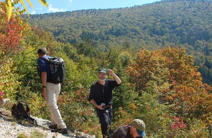 
Sixteen hikers enjoyed this new CMC on the west slopes of the Black Mtn. range. This area has never been explored by CMC and offers many possibilities for future CMC hikes. Led by Jake Blood and John Whitehouse, we first drove a very rocky road up to the 4200' level near the Whitehouse cabin, then hiked up the old logging RR roadbed and the wagon road up to the abandoned Isom mica mine. The views of the Black Mtn. range from our lunch spot at the mine were impressive. The mine remains consist of a lower horizontal tunnel and an upper vertical shaft, along with a large pile of tailings containing various minerals.
After lunch, we continued up the mountain on the RR grade and then descended on a dozen switchbacks to our cars. Sandy Whitehouse had a surprise for us at their cabin--a big setting of cheese and veggies, along with wine to accompany it
We thank Sandy and John for arranging this treat. They are rehabbing their cabin for rental purposes and may be contacted by anyone interested.
After the hike, eight of us enjoyed supper at North Star Diner in Weaverville. Bruce. Photo on left by Ted Connors, on right by Bruce Bente.
Half Day Sunday
HALF-DAY No. H0803-318 Sept. 28
Big Ridge Overlook to Beaver Dam Overlook *1:00 PM
Hike 4.4, Drive 35, Rated C-C
Nonmembers, call leader, Paula Robbins, 828-281-3253, paularww@bellsouth.net
P400 *Note early start time. This in-and-out hike along the MST near milepost 403 of the Blue Ridge Parkway is a good one for beginners. It will feature some fall wildflowers and good views. Second meeting place French Broad Overlook of the Blue Ridge Parkway at M.P. 393 at 1:10 PM.
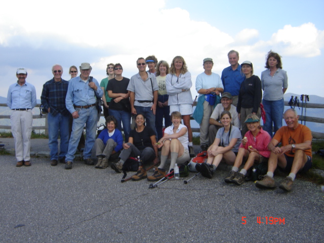
After a week of gas shortages, 26 CMC members gathered for a nearby hike on the Mountains-to-Sea Trail from Beaver Dam Overlook to Big Ridge Overlook and return. With so many hikers, it seemed prudent to divide the group, and Don Walton graciously led a faster group. The early fall season was evident, with sourwood and Virginia creeper leaves turned red and goldenrod, a variety of asters and the rare closed gentian blooming along the trail. A variety of native ferns, including maidenhair, were seen next to the west side of the trail between Stony Bald and Big Ridge Overlooks. A staff photographer from the Asheville Citizen-Times took photos that will appear with a story in this week’s Outdoor Section. Paula
HALF-DAY NO. H0804-116 Oct. 5
Craggy Picnic Ground to Greybeard Overlook *12:30 PM
Hike 5.5 miles, 1100 ft. ascent, rated C-B
Nonmembers, call leader, Marcia Bromberg, 828-505-0471, mwbromberg@yahoo.com
*Note early meeting time. From the Craggy Gardens Picnic Area we climb up a short distance to the top of bald Craggy Knob with a view to the south. Then back to the MST and down below the closed and quiet BRP visitor center. From there we continue on the MST around Craggy Pinnacle on a rocky and difficult part of the trail, then cross the parkway as the MST continues to Greybeard Overlook and another fabulous view, before returning to our cars. Second meeting place: Folk Art Center, lower parking lot, at 12:50 PM
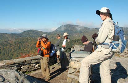
 The beautiful weather and special mention of the hike in a Citizen-Times article about the Mountains-to-Sea Trail helped draw 22 hikers last Sunday. And because this hike was listed as an MST month hike we spent a few minutes before the hike learning about the trail and the CMC's role in building and maintaining a 93 mile section. The beautiful weather and special mention of the hike in a Citizen-Times article about the Mountains-to-Sea Trail helped draw 22 hikers last Sunday. And because this hike was listed as an MST month hike we spent a few minutes before the hike learning about the trail and the CMC's role in building and maintaining a 93 mile section.
As promised in the hike description, most of the section of the MST this hike traversed was rocky and difficult. But everyone stepped carefully, enjoying sporadic views through the trees and good conversation with one another. After reaching and resting at the Graybeard Mountain overlook the walk back along the Blue Ridge Parkway and over Craggy Know was relaxing and enjoyable. Marcia.
All Day Wednesday
WEDNESDAY No. W0804-625 Oct. 1
Devil’s Courthouse-Daniel Ridge Creek *8:30 AM
Hike 8.5, Drive 74, 2100 ft. ascent, Rated B-AA
Ashok Kudva, 828-698-7119, ashok.kudva@mchsi.com.
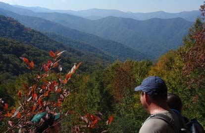
P400, SB6K: *Meet at Westgate at 8:30 AM to form carpools, and meet leader at Cold Mtn. Overlook at 9:10 AM. From Devil’s Courthouse overlook, we will proceed on the MST, do a steep descent on the Art Loeb Trail and Farlow Gap Trails to Daniel Ridge Creek, Along the way we’ll view old mica mine tailings and waterfalls, then retrace our steps to the BRP/ALT intersection. This hike will feature a 360 degree mountain vista from Devil’s Courthouse, a fabulous view of Pilot Mountain from Chestnut Bald overlook and Silvermine Bald, and early fall foliage colors. Optional in-and-out climb to Chestnut Bald for SB6K fans. Short car shuttle. Topos: Sam’s Knob, Shining Rock; also Natl. Geo. PRD map #780
On the CMC website I posted the scouting report which canceled the originally posted hike from
Devil’s Courthouse to Daniel Ridge Creek. It had a steep, rocky, slippery descent on the Farlow Gap Trail. Instead, seven of us hiked from Devil’s Courthouse to Pilot Mountain on well maintained trails of MST and ALT. Mountain vista from Devil’s Courthouse, Chestnut Bald Overlook and the Pilot Mountain summit were spectacular. After the hike 3 hikers enjoyed supper at Ed Boudreaux’s Bayou BBQ in Brevard. Ashok. Photo by Ted Connors
WEDNESDAY No. W0804-076 Oct. 8
Craggy to Little Snowball Hike 8:30 AM
Hike 7.2, Drive 38, 2630 ft. ascent, Rated B-AA
Don Walton, 828-654-9904, donwalton@bellsouth.net.
From Bee Tree Gap at Craggy Gardens, we’ll go 135 feet on MST South, then get on Snowball trail over high rocks (Hawkbill Mtn.) to Little Snowball tower site for great views. We’ll return on the same route. Second meeting place: Bee Tree Gap at 9:00 AM. Topo: Craggy Pinnacle; also USFS South Toe River, Mt. Mitchell & Big Ivy Trail Map
The hike was rained out. Don
All-day hikes submitted by Bruce Bente 692-0116, bbente@bellsouth.net . Driving distance is round-trip from Asheville. All Saturday and Sunday hikes assemble at Westgate Shopping Center near I-240 UNLESS OTHERWISE NOTED.
Half Day hikes submitted by Lucy Prim 828-693-6580 lucette32@mchsi.com.
Wednesday Hikes are submitted by Charlie Ferguson, 828-398-0213 ccf108@gmail.com and Ann Gleason, 828-859-9387,
gleason.ann@gmail.com .
The meeting place for each hike will be designated by the hike leader and will appear in the hike description.
Driving mileage will be listed, round trip, from the first designated meeting place.
Leaders: Mail please mail your sign-up sheets. Meet at Westgate unless otherwise noted. |
