|
All Day Saturday & Sunday
ALL DAY No. A0804-397 Nov. 23
Bad Fork – Chestnut Cove Overlook *8:30 AM
Hike 9.5, Drive 80, 1300 ft. ascent, Rated A-B
Charlie Ferguson, 828-333-5165, ccf108@gmail.com
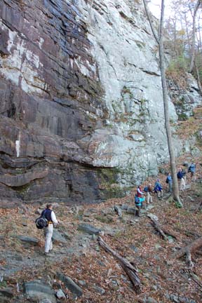
P400 *Note later start time. This is an in-and-out hike that begins at the Trace Ridge trailhead. We will hike up Bad Fork to the BRP (a steep 700 ft. ascent for the second mile) to Bent Creek Gap, and then follow the MST to the Chestnut Cove Overlook to enjoy a beautiful view during lunch. Return by the same route. Second meeting place: Trace Ridge Trailhead at 9:00 AM. Topo: Dunsmore Mtn; also Nat’l. Geo. PRD map #780, and MST Profiles, pgs. 55-56
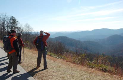 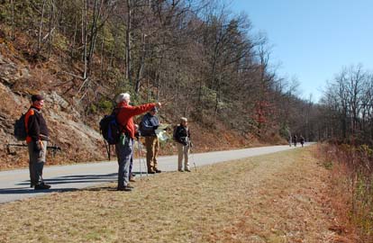
We hiked this one as it was scouted - about 10.5 miles. The weather started out chilly but warmed up in the sun nicely. The Bad Fork trail itself is a very nice trail - even grade, not much erosion, easy on the feet. The MST was partly in the shade and had a light dusting of snow. The ten of us had lunch at the Chestnut Cove Overlook on the Parkway. The parkway was closed due to recent snow in places so we had it all to ourselves on our walk back to the Bad Fork trail. On our walk through the tunnel there was one bicyclist who thought that he owned the parkway and the tunnel. We let each other pass amicably. On the way back we looked for the old Bad Fork trail, shown on the USGS and National Geographic maps. We thought we might have found it but it is heavily overgrown. The trails were so easy that the hike didn't feel like 10.5 miles. Charlie. Photos by Ted Connors.
ALL DAY No. A0804-328 Nov. 30
Bent Creek Loop #5 – Ingles Field *9:00 AM
Hike 8, Drive 20, 800 ft. ascent, Rated B-C
Tom Sanders, 828-252-6327, tomary2@charter.net
P400 *Note later start time. Here’s a chance to work off some of that Thanksgiving turkey with a moderate hike in the Bent Creek area. From Hardtimes trailhead, we’ll do a loop hike around Lake Powhatan, Explorer and Sidehill Trails, and descend past Ingles Field to our cars. Topo: Dunsmore Mtn.; also Nat’l. Geo. PRD map #780 and Bent Creek Trail Map
With the temperature 35, a steady rain, and no one showing up at Westgate except me (and I didn't really want to hike under these conditions), the scheduled hike was cancelled. Tom
Half Day Sunday
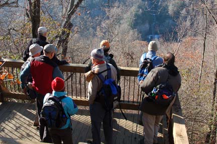
HALF-DAY No. H0804-062 Nov. 23
Daniel Ridge Loop Trail *12:30 PM
Hike 4, Drive 70, 800 feet ascent, Rated C-C
Nonmembers, call leader, Stuart English, 828-883-2447, stuengo@citcom.com
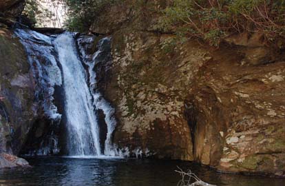
P400 *Note early start time. Meet at Westgate at 12:30 PM to form carpools, and meet leader at Fish Hatchery parking lot off FS475 at 1:15PM. The trail climbs gradually along a lovely stream beside small waterfalls. A larger waterfall is seen just before the end of the hike.
Twenty-two people met at the Pisgah Fish Hatchery for this hike on what turned out to be a beautiful late fall day.
 It warmed up to about 50 degrees and that is perfect hiking weather. The hike started about two miles from the new fish hatchery and passed what was once the old fish hatchery on Daniel Ridge Creek. We hiked up Daniel Ridge Creek and Right Fork (two beautiful streams) then crossed over a ridge back into the warmth of the sun and eventually down to the base of Toms Spring Falls. There was only a trickly of water going over this lovely 150' tall waterfall. We were very fortunate to have on the hike Dwight McCarter from Gatlinburg. Dwight is a retired Back Country Forest Ranger who worked in the Smoky Mountains National Park. He entertained and educated us on flora and fauna and added another much needed Southern accent to the hike. We look forward to seeing Dwight on many more hikes. Stuart. Photo by Stuart English It warmed up to about 50 degrees and that is perfect hiking weather. The hike started about two miles from the new fish hatchery and passed what was once the old fish hatchery on Daniel Ridge Creek. We hiked up Daniel Ridge Creek and Right Fork (two beautiful streams) then crossed over a ridge back into the warmth of the sun and eventually down to the base of Toms Spring Falls. There was only a trickly of water going over this lovely 150' tall waterfall. We were very fortunate to have on the hike Dwight McCarter from Gatlinburg. Dwight is a retired Back Country Forest Ranger who worked in the Smoky Mountains National Park. He entertained and educated us on flora and fauna and added another much needed Southern accent to the hike. We look forward to seeing Dwight on many more hikes. Stuart. Photo by Stuart English
HALF-DAY No. H0804-102 Nov. 30
Coon Tree Loop *12:30 PM
Hike 3.7, Drive 65, 1200 ft ascent, Rated C-B
Nonmembers, call leader, Lucy Prim, 828-693-6580, lucette32@mchsi.com
*Note early start time. Meet at Westgate at 12:30 PM to form carpools, and meet leader at Pisgah Ranger Station on US 276 at 1:10 PM. This hike is a loop along both sides of a lovely creek, with views along Coon Tree Mountain ridge on top. Some steep areas.
Nobody came to the hike! I waited at the Pisgah Ranger Station until 1:35 and then went home. It was really for the best, considering how cold and rainy it was. I was relieved to just go home and have a hot cup of tea! Lucy.
All Day Wednesday
WEDNESDAY No. W0804-460 Nov. 19
Pilot Mtn. to Courthouse Falls 9:00 AM
Hike 9, Drive 60, 1300 ft. ascent, Rated A-B
Mary Beth Gwynn, 828-254-2042, mbgcmc@gmail.com
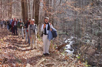
P400 This in and out hike begins with a short bushwhack below Pilot Mtn. and follows FS 140A through interesting forest to FS 140 and on to Courthouse Falls. This route affords a different view of Devils Courthouse. There is one easy stream crossing (Kiesse Creek). Second meeting place: PRD Ranger Station at 9:30 AM. Topo: Shining Rock, Sams Knob; also Nat’l. Geo. PRD Map #780.
Fifteen hikers met to hike FS 140A and FS 140 to Courthouse Falls from a trail near Deep Gap shelter at Pilot Mountain. Getting down to FS 140A required using a steep, short, slippery trail from Deep Gap area. Hikers commented that the least the leader could have done was used a leaf blower to clear the path ahead of time. Since the auto industry crisis had been resolved in the drive over to the hike from Westgate, the leader considered this criticism minor.
 It was a beautiful day for walking in the woods. Icicles sparkled in the sun. The relatively wide trail allowed for conversation. One group considered the pros and cons of deep-frying turkeys. Hikers arrived famished at Courthouse Falls after the hike leader missed the trail down to the Falls and had to be called back by a whistle. The Falls were lovely and encrusted with ice. Spirits were high after lunch. The return hike was idyllic for the most part. More complaints about the leader not having properly prepared the steep trail to the Deep Gap area were heard as hikers climbed back up the hill at the end of the hike. The driver of the car the leader traveled in said the leader would be charged twice the gas money as her other occupants for just this reason. (The driver relented at the end.) It was a beautiful day for walking in the woods. Icicles sparkled in the sun. The relatively wide trail allowed for conversation. One group considered the pros and cons of deep-frying turkeys. Hikers arrived famished at Courthouse Falls after the hike leader missed the trail down to the Falls and had to be called back by a whistle. The Falls were lovely and encrusted with ice. Spirits were high after lunch. The return hike was idyllic for the most part. More complaints about the leader not having properly prepared the steep trail to the Deep Gap area were heard as hikers climbed back up the hill at the end of the hike. The driver of the car the leader traveled in said the leader would be charged twice the gas money as her other occupants for just this reason. (The driver relented at the end.)
Back at the parking area, Ashok passed out CMC car decals to members and CMC applications to non-members. Conversation on the return car trip was lively in at least one car. Topics included: ideal starting times for ½ day Sunday hikes; adventures with aging parents; the benefits of establishing a CMC dress code for (presumably) women hikers which recommends mini-skirts and full make-up; and Charlie’s achievement of buckling his seat belt single handedly. Many thanks to the fourteen hikers who made this hike leader’s first hike such a pleasure! Mary Beth Gwynn. Photo by Ted Connors.
WEDNESDAY No. W0804-519 Nov 26
Raven Cliff Falls, Cathedral Rock, Dismal Trail Loop 8:00 AM
Hike 9, Drive 95, ascent 2300 ft, Rated A-A
Ann Gleason, 828-859-9387, gleason.ann@gmail.com
Get ready for the “turkey chow down” with this scenic loop hike featuring waterfalls, stone cliffs and a double-cable crossing over Matthews Creek (look up hike #519 on website to see pictures of it). From the Raven Cliff parking lot, we take the #13 Gum Gap trail, then #14 Naturaland Trust trail descending down to the #12 Dismal Trail where we will cross the rushing waters of Matthews Creek on a cable, ascend the dramatic Cathedral Cliff alongside and over Raven Cliff Falls and back to cars. If water is low, you can rock-hop creek (if the cable isn’t your cup of tea). Additional meeting places: Bi-lo parking lot at Pisgah Forest at 8:30 AM, and Raven Cliff Falls Parking lot on US 276 at 9:00 AM. Topo: Table Rock; also Mountain Bridge Wilderness Area trail map
It was a pleasure to lead the November 27, 2008 hike for Ann Gleason. It was also a pleasure to meet Ann when we scouted the hike. The hike was full of firsts: first time I led a hike, first time I made it to the top of the mountain before everyone, and finally the first time a 9.5 mile hike was completed in 7.7 miles. Kidding aside, Charlie is going to fix the mileage issue and the hike went smooth (except I forgot to have introductions before we embarked). We had sun on the way down the mountain and shade on the way up the other side. No one fell off of the cable crossing and we had a chilly lunch at the top of the falls. Finally a leisurely 3.3 mile hike back to our cars. I can't wait to lead another hike on December 7, 2008 also at Caesar's Head. Thanks to Ted for running sweep. Jeff.
All-day hikes submitted by Bruce Bente 692-0116, bbente@bellsouth.net . Driving distance is round-trip from Asheville. All Saturday and Sunday hikes assemble at Westgate Shopping Center near I-240 UNLESS OTHERWISE NOTED.
Half Day hikes submitted by Lucy Prim 828-693-6580 lucette32@mchsi.com.
Wednesday Hikes are submitted by Charlie Ferguson, 828-398-0213 ccf108@gmail.com and Ann Gleason, 828-859-9387,
gleason.ann@gmail.com .
The meeting place for each hike will be designated by the hike leader and will appear in the hike description.
Driving mileage will be listed, round trip, from the first designated meeting place.
Leaders: Mail please mail your sign-up sheets. Meet at Westgate unless otherwise noted. |
