|
All Day Saturday & Sunday
ALL DAY No. A0804-537 Dec. 7
Coggins – Rim of the Gap –Pinnacle Pass – Naturaland Tr. *8:00 AM
(strenuous)
Hike 10.5, Drive 110, 2800 ft. ascent, Rated A-AA
Jeff McGurk, 864-921-6469, jbsbestfan@hotmail.com
*Meet at Westgate at 8:00 AM to form carpools, and make stop at Bi-Lo in Pisgah Forest at 8:30 AM for additional hikers. Meet leader at Caesar’s Head Visitor Center parking lot at 9:00 AM. From the Visitor Center, we’ll do a loop hike in the Mountain Bridge Wilderness Area. We’ll start on the Frank Coggins Trail and continue on the Rim of the Gap, then cut over to the Pinnacle Pass Trail. We’ll follow this steeply down and then up to intersect with the Naturaland Trust Trail back to our cars. Caution: If the weather is cold, there will be ice on the Rim of the Gap Trail. Topos: Cleveland, Table Rock; also Mountain Bridge Wilderness Area Trail Map
No report.
ALL DAY No. A0804-538 Dec. 7
Vineyard Gap – Forge Mtn. Loop *9:00 AM
(moderate)
Hike 7.5, Drive 55, 800 ft. ascent, Rated B-C
Marianne Newman, 828-257-2136, marianneln@msn.com
P400 *Note later start time. This is a nice loop hike from the Turkey Pen parking area, including a walk along the Forge Mtn. ridge, a pleasant stroll along the S. Mills River, and ending with a short, steep climb over a ridge to the parking area. Second meeting place: Turkey Pen parking area at 9:30 AM. Topo: Pisgah Forest; also Nat’l. Geo. PRD map #780
Eleven hikers enjoyed this varied and scenic combination of trails in the Turkey Pen area of Pisgah Forest.
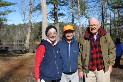
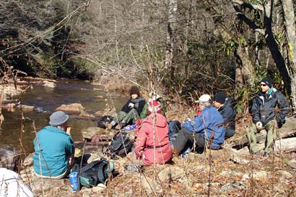 Though the wind was fierce at Westgate, it was a gorgeous day atop the Forge Mountain ridge and along the S. Mills River. It was fun to see, but not do, the several river crossings our route might have included. After a short but impressively steep climb back up Forge Mountain, the group at first agreed upon adding a brief exploratory trip on an unknown, unnamed trail to extend the hike a little. However, it soon became clear that the trail was going to go pretty directly back down the mountain, and that was the end of that. The hike, though shorter than its announced mileage, was quite fine as planned. Marianne. Photo by Stuart English. Though the wind was fierce at Westgate, it was a gorgeous day atop the Forge Mountain ridge and along the S. Mills River. It was fun to see, but not do, the several river crossings our route might have included. After a short but impressively steep climb back up Forge Mountain, the group at first agreed upon adding a brief exploratory trip on an unknown, unnamed trail to extend the hike a little. However, it soon became clear that the trail was going to go pretty directly back down the mountain, and that was the end of that. The hike, though shorter than its announced mileage, was quite fine as planned. Marianne. Photo by Stuart English.
ALL DAY No. A0804-609 Dec. 14
Rich Mtn., Round Top Ridge Trail and AT 8:00 AM
Hike 11.5, Drive 70, 2700 ft. ascent, Rated A-AA
Tish Desjardins, 828-656-2191, desraylet@aol.com
*After the hike there will be a potluck supper in the nearby Bear River Community Lodge. Hikers are requested to contribute food for the supper. Food will be taken to a refrigerator before the hike. Please phone the leader to coordinate what food to bring. From Tanyard Gap we will go north on the AT to the beautiful views from Rich Mountain, then descend to Hot Springs via Round Top Ridge Trail, and return on the Pump Gap Trail and AT to Tanyard Gap. Topo: Hot Springs; also Appalachian Ranger District “Hiking trails in the Hot Springs area” map
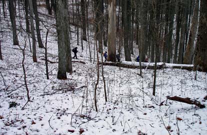 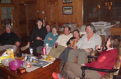
We hiked AT north, Rich Mountain fire tower, A.T. south, Round Top Ridge Trail, River Road in Hot Springs to the Pump Gap trail and, then, the A.T. north to finish at Tanyard Gap. Beautiful hike with plenty of mountain views. Dustings of snow were visible and looked very pretty on the trees. Nice views from Rich Mountain fire tower. We saw persimmon trees at Mill Ridge on the A.T. going north. We had a delicious potluck supper after and enjoyed the camaraderie and toast to Kathy & Michael Cornn. Tish. Photos by Stuart English.
Half Day Sunday
HALF-DAY No. H0804-623 Dec. 7
Kitsuma Peak *12:30 PM
Hike 5 miles, 2000 ft ascent, Rated C-AA
Nonmembers, call Tom Sanders 828-252-6327, tomary2@charter.net
*Note early start time. This popular but somewhat strenuous hike begins near Old Fort and ascends Young Ridge to Kitsuma Peak, overlooking Ridgecrest. Outstanding views along the way. Car shuttle. Second meeting place: parking lot adjacent to McDonalds off I-40 at Exit 64 of I-40 at 12:50 PM.
It started out as a cold, windy, but clear day. Marcia Bromberg and Tom were the only ones at Westgate, and we talked about canceling, but since there was a second mtg place in Black Mountain, we had to check there. Driving there it looked so pretty outside that we decided that even if it was just us two, we'd do the hike. However, in Black Mountain there were 11 more, for a total of 13 and off we went. Furthermore, the wind had disappeared. This turned out to be one of those great winter days, not too cold, sunny, negligible wind.
The hike in itself is beautiful. Starting near Old Fort we ascended to Young Ridge and then continued along to Kitsuma, with very nice views especially toward the Craggy Range and surrounding areas. From the top of Kitsuma we descended to a parking area near Ridgecrest, where we had left half our cars. Because of the uphill this was more strenuous than most half-day hikes, but the hikers handled it fine and certainly enjoyed it. Tom
HALF-DAY No. H0804-624 Dec. 14
Dupont Forest Hooker Falls P.L. #2 (Wintergreen Falls) *12:00 Noon
Hike 5, Drive 70 miles, Rated C-C
Nonmembers, call leader, Becky Elston, 828-749-1886, belston@cytechusa.com
*Note early start time. Meet at Westgate at 12 noon to form carpools, and meet hike leader at Hooker Falls parking lot in Dupont Forest at 12:50 PM. A leisurely paced walk down old logging roads through some beautiful forests.
After all the rain of last week, Wintergreen Falls in Dupont was great. A nice group of 14 braved the gray day to have a pleasant walk in the woods. Becky
All Day Wednesday
WEDNESDAY No. W0804-492 Dec. 3
Annual Cookie Hike: Bent Creek Ramble *8:30 AM
Hike 7, Drive 25, 1000 ft. ascent, Rated B-B
Ken and Carol Deal, 828-281-4530, cnkdeal@charter.net.
Moderate loop hike in the Bent Creek area: *Meet at Westgate at 8:30 AM to form carpools, and meet the leaders at Ingles parking lot across from Biltmore Sq. on NC 191 at 8:40 AM. We will start from the parking area for Cold Knob Rd (FS 479H) off Bent Creek Rd beyond Lake Powhatan. Using a variety of short sections of trails, we will hike up to the MST, past Sleepy Gap and descend on the Stambaugh Trail to Lake Powhatan picnic area for lunch and cookie feast. Afternoon return walk back to cars is 2 miles. Bring cookies to share. Topos: Dunsmore, Skyland; also Nat’l. Geo. PRD map #780 and Bent Creek Trail Map
WEDNESDAY No. W0804-i Dec 3
Alternate - shorter Cookie Hike *10:00 AM
Hike 4, Drive 10, Rated C-C
Sherman Stambaugh, 828-254-1736.
Easy 4 mile hike in the Bent Creek area. *Only meeting place: Ingles parking lot across from Biltmore Square on NC 191. We will meet the 1st group for lunch and cookies at Lake Powhatan at noon and return to cars. Call Sherman if you want to go on this shorter hike. Bring cookies to share. Topo: Skyland; also Bent Creek Trail Map
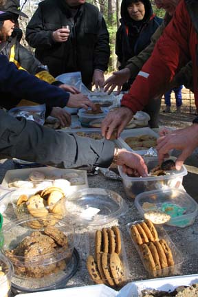 
The appeal of a myriad of delicious cookies brought out a total of 46 hikers for the December 3rd cookie hike. One group met Ken and Carol for a 9:00 start on a loop that took us up to the MST and back down to the picnic area, and another group met Sherman at 10:00 for a ramble in the Bent Creek area. The two groups met for lunch at the Lake Powhatan picnic area. There were many, many delicious cookies brought by the hikers for sharing. All left with a sugar "high" that we worked off before we returned to the cars. Carol. Photos by Danny Bernstein
WEDNESDAY No. W0804-277 Dec.10
Bent Creek Loop #2 8:30 AM
Hike 9-10, Drive 20, 1600 ft. ascent, Rated A-A
Ruth Hartzler 828-251-0886, ruthmtn@charter.net
P400 A nice Bent Creek loop originated by Tom Bindrim, starting at the Hardtimes trailhead. We will hike part of the MST, a little easy off-trail (about 1/3 mile), the Lower Sidehill Trail, and stroll past Lake Powhatan. A great close-in, cool-weather hike. Topo: Dunsmore Mtn., Skyland, and Nat’l. Geo. PRD map #780
After waiting at Westgate in the pouring rain, no one showed up. Not even CMC'ers wanted to hike. Hike cancelled. Two inches of rain during the day. Ruth
All-day hikes submitted by Bruce Bente 692-0116, bbente@bellsouth.net . Driving distance is round-trip from Asheville. All Saturday and Sunday hikes assemble at Westgate Shopping Center near I-240 UNLESS OTHERWISE NOTED.
Half Day hikes submitted by Lucy Prim 828-693-6580 lucette32@mchsi.com.
Wednesday Hikes are submitted by Charlie Ferguson, 828-398-0213 ccf108@gmail.com and Ann Gleason, 828-859-9387,
gleason.ann@gmail.com .
The meeting place for each hike will be designated by the hike leader and will appear in the hike description.
Driving mileage will be listed, round trip, from the first designated meeting place.
Leaders: Mail please mail your sign-up sheets. Meet at Westgate unless otherwise noted. |
