CMC Bi-Weekly Hike Reports
Looking Back - February 6th, 2009
| All Day Saturday and Sunday Hikes |
| Half Day Sunday Hikes |
| Wednesday Hikes |
All Day Saturday & Sunday ALL DAY NO. A0901-268 Jan. 25
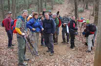
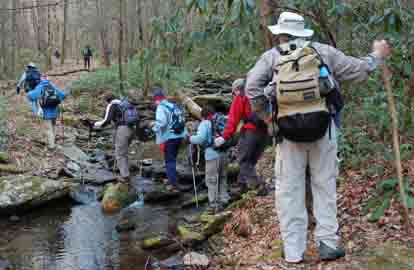
--Photos by Ted Connors Eighteen hikers set out from Jones Gap State Park to enjoy the Mountain Bridge Wilderness Area of South Carolina. Weather was perfect, with temps in the 40's and a cloudy morning that gave way to mixed sunshine in the afternoon. The hike started out with a steep climb up the Hospital Rock Trail. Everyone enjoyed a snack break at the Hospital Rock, a hideout for Civil War deserters. Lunch was had at Pretty Place on top of the Cleveland Cliffs. To call the view from Pretty Place, aka Symme's Chapel, breathtaking is an understatement. We could see the road leading to the parking lot far below us. After lunch, the group proceeded along a short road walk to the trail leading downwards to Rainbow Falls. The trek down to Rainbow Falls involved some steep, rocky trail. One section of trail was particularly challenging, requiring the aid of a small section of rope to successfully navigate it. However, the reward for hard trekking was a stunning up close view of Rainbow Falls. Two to three foot sections of snowdrift remained from the ice/snow fall earlier in the week. This allowed some intrepid members of the group to get very close to the falls, much closer than is normally attainable. After a few snowballs and some lighthearted talk of building a snowman, the group (reluctantly) headed down the newly constructed Rainbow Falls trail towards the Middle Saluda River. On the way down, the group passed many upward bound hikers heading towards the falls. On the way up Hospital Rock trail, we had seen not a soul. The hike ended at a leisurely pace and we arrived back at Jones Gap Ranger Station approximately 3:30 pm. We caught the Ranger just as he was closing up shop, but he courteously agreed to keep the place open as several members of the group wished to purchase maps before leaving. Afterwards, everyone agreed it was a great hike and all had enjoyed the scenery and the company of their fellow hikers.--Matt Sowles SATURDAY NO. A0901-632 Jan. 31 Danny was hit by a car three weeks before the hike and was unable to lead this hike. She’s on the mend and has already done a half day Sunday hike. Lenny pitched in as Leader and was able to provide a little of the history, but nowhere near the job that Danny would have done. Eight of us braved the early morning cold and were rewarded with a picture-perfect day as temperatures rose into the 50s by noon. The hike proceeded as planned until the last bridge, a foot bridge over Cantrell Creek, about 100 yards from the chimney that marks the former site of Cantrell Lodge. The handrail on the bridge was out, and since the bridge is a slippery log, high above Cantrell Creek, nobody crossed it. Instead, six of us walked across the horse crossing a little upstream of the bridge. We got our boots wet, but that was all. The other waited until we returned, about 10 minutes later. On the way back we took the Pounding Mill Trail up to an old road which connected with the Mullineaux Trail. Lenny and Bruce Bente had scouted the old Mullinax Trail, but the entrance to it was hard to find, and it was an uninteresting walk in the trees, so Lenny opted to stay on the Mullineaux Trail until it connected with the South Mills River Trail.--Lenny Bernstein ALL DAY NO. A0901-493 Feb. 1
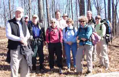
Photo by Carroll Koepplinger The morning was crisp as we left the cars at F497H (Cold Knob Rd) off the Bent Creek Gap Rd. The eleven hikers warmed up on the climb to the Parkway via the Explorer Loop Trails and the Chestnut Cove Trail. Most hikers removed a lawyer of clothing for the bushwhack up to the summit of Pine Mountain. After a short climb to Double Head we enjoyed a sunny lunch spot on a large fallen tree. We had a clear view of Pisgah Mt. and much discussion was had on identifying the other peaks to the south west. We retraced our steps back to Pine Mt. and followed the boundary ridge to Cold Knob. We descended to the MST at Bent Creek Gap where after a twenty minute hike we bushwhacked north to the South ridge Rd. We turned north west on the Bent Creek Gap Rd. to the Lower Side Hill Trail for our loop back to the cars. On this trail we took a break and enjoyed the open forest on the slopes. I think everyone enjoyed the challenge and the balmy weather. Many thanks to Tommie Boston and Stuart Tauber for their help in scouting and for Stuart's help in leading the hike.--Joanne Tulip ALL DAY NO. A0901-633 Feb. 1
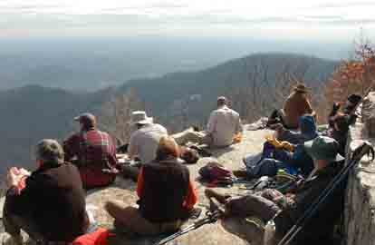
Photo by Ted Connors On Sunday, February 1st, twenty four hikers braved one of the most beautiful days this winter to hike up Curtis Creek and onto the ridgeline that runs out to Buckeye Knob. The hike afforded outstanding views of the Mackey Mountain Roadless area, a 5,000 acre area that contains one of the largest tracts of uncut forest in western North Carolina, as well as many other significant peaks of the Black Mountains. A side trip out to one of the old growth areas allowed hikers to see first hand a few of the area’s large northern Red Oaks, Tulip trees, Black Locusts, and more.--Brent Martin HALF-DAY NO. H0901-153 Jan. 25 Twenty-three hikers enjoyed the winter scenery on this warm and dry winter day. We hiked up the entrance road for the Cove Creek Group Camp, passing the popular swimming cascades on the way. We hiked around the campground on the Caney Bottom Trail and left the trail at Cove Creek to go upstream to Cove Creek Falls, a beautiful inclusion on the WC100 Challenge. From the falls we worked our way upward to the Cove Creek Trail and continued north to the bridge over Cove Creek where we stopped for a snack. On the way to the Junction with the top end of the Caney Bottom Trail, we passed a large inviting meadow which would be worth an exploration on another day. The return trip took us down Caney Bottom Creek with it’s large waterfalls. As we approached the end, a downy woodpecker was spotted along with evidence where a bobcat had sharpened its claws on a tree, leaving a footprint at its base.--Lee Belknap HALF-DAY NO. H0901-637 Feb. 1 Twenty-two hikers assembled at the Destination Center on a beautiful sunny day to hike the new 1.4 mile loop and an in and out to the Folk Art Center. We started by going west on the MST blue blaze trail to Hwy 74A MST entrance on the south side of the BRP. Then we headed east on the MST trail to the trail junction where the loop heads back under the BRP to the Destination Center. We then continued 2.2 miles to the Folk Art Center. We enjoyed a leisurely break at the Folk Art Center picnic tables and arrived back at the cars about 4pm.--Don Walton WEDNESDAY NO. W0901-457 Jan. 28 Scout Date: Friday Jan. 16 No one showed. Folks called last night and this morning to say they'd prefer not to hike in wet weather. Charlie and I went to both locations to make sure no one was interested.--Mary Beth Gwynn TUESDAY Feb. 3 - Scout of Sunday Feb. 15 hike-418 in the Smokies : Janet Martin, 502-494-9309 (cell), jaykaymartin@msn.com WEDNESDAY NO. W0901-629 Feb. 4
All-day hikes submitted by Bruce Bente 692-0116, bbente@bellsouth.net . Driving distance is round-trip from Asheville. All Saturday and Sunday hikes assemble at Westgate Shopping Center near I-240 UNLESS OTHERWISE NOTED. Half Day hikes submitted by Lucy Prim 828-693-6580 lucette32@mchsi.com. Wednesday Hikes are submitted by Charlie Ferguson, 828-398-0213 ccf108@gmail.com and Ann Gleason, 828-859-9387, gleason.ann@gmail.com . The meeting place for each hike will be designated by the hike leader and will appear in the hike description.
Driving mileage will be listed, round trip, from the first designated meeting place. |