CMC Bi-Weekly Hike Reports
March 6th, 2009 -- Looking Back
| All Day Saturday and Sunday Hikes |
| Half Day Sunday Hikes |
| Wednesday Hikes |
All Day Saturday & Sunday ALL DAY NO. A0901-634 Feb. 22
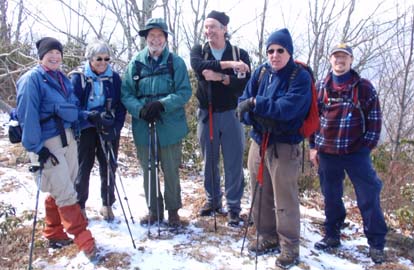
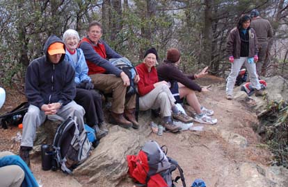
Photo by Carroll Koepplinger At 7:00 am the day didn't seem promising: cold, quite windy and a forecast of cloudy. Perhaps 3 or 4 might show up. To the leader's astonishment 17 were at Westgate and Camp Daniel Boone. The route of this hike has changed somewhat because the Camp is selling timber, and a new steep and muddy logging road has been built to replace what was once a nice overgrown woods road. Logging roads can be confusing because they go off in various directions. Up we started and all went well until -- ahem -- the leader took a left instead of a right (he had scouted it, I swear). That road ended and for the next 40 minutes at least, we bushwhacked, mainly steep up, misled by snatches of what looked like a road, until we finally did find ourselves on the proper road after much consultation and the GPS's. I'm sure the several new hikers thought CMC was a mess, but it was mea culpa. I told them that most of our hikes are, really, different. By then things were clearing, and we were getting exceptional views of the ridge that stretches from Black Balsam to Cold Mtn. So this day was turning out to be one of those great winter hike days, cold and clear. By noon we had reached the crest of the ridge and on the steep incline up to the former tower site on Hightop we found a rock face with beautiful views of the mountains between Sunburst and Mt. Hardy and even off to the Plotts. After lunch we hiked along the ridge called Fork Mtn on the map as far as Birdstand Mtn, where we dropped off to an old logging road, which we followed to the left down to the Little East Fork near the Camp. This latter route was different from what we normally did, which was to turn right on the old logging road, but on the scout we had discovered this alternate route, which is excellent for getting from Birdstand to the Camp. For this hike (minus the bushwhack and confusion ) consider 9.5 miles and about 2,500 ft elevation.--Tom Sanders SATURDAY NO. A0901-019 Feb. 28 The Feb. 28 hike was canceled due to rain. Sigh--Becky Smucker. ALL DAY NO. A0901-635 March 1 Due to bad weather, this hike was cancelled.--Editor ALL DAY NO. A0901-236 March 1 Three winter ducks (hikers) and I went on a soggy hike in Dupont Forest on Sunday. The weather started with a combination of rain and sleet with intermittent dry spells. We changed our route so we could enjoy Triple Falls, High Falls and Bridal Veil Falls. With the recent winter rains, all Falls were at high water levels and were magnificent. Heavy snowfall began at noon. We ate our lunch in an airplane hanger up on the airstrip. Returning back to the car we enjoyed the snowfall in the woods. Even though all of us were soggy our spirits were not dampened. The road out of Dupont was snow covered but most other roads home were just wet. We returned to Westgate safely and headed straight home for hot showers and a beverage of our choice.--Cheers, Jay Bretz HALF-DAY NO. H0901-431 Feb. 22
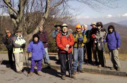
Photo by Lee Belknap I’ve always considered winter the best time for hiking in Bent Creek, and Sunday was no exception. A cold wind nearly blew us out of the parking lot, but the valley provided us with some protection and the sky was blue and clear as 13 of us began to climb the Explorer Loop trail toward the MST. A light dusting of snow greeted us as we followed the unmarked but well maintained trail along Chestnut cove to the MST. We had excellent winter views from the deserted Chestnut Cove Overlook and then continued along the MST to the Sleepy Gap Overlook where we found a sunny spot sheltered from the wind for lunch. The Sleepy Gap trail was frozen and covered in light snow as we began our descent, but as we began our final mile along the Explorer Loop trail the afternoon sun warmed us for a delightful concluding walk in the woods. It was a good day.--Joe Burchfield HALF-DAY NO. H0901-283 Mar. 1 I was going to lead Marcia's hike in Montreat yesterday, but we canceled due to weather.--Marlene Santa Maria All Day Wednesday WEDNESDAY NO. W0901-632 Feb. 18
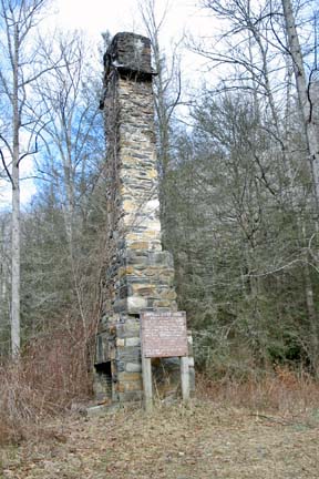
Photo by Danny Bernstein It was a wet, miserable day but I was still having trouble deciding if I should cancel the hike to Cantrell Creek Lodge site. No one showed up at Westgate, so that decided it for me. The photo of the chimney is what we missed, by not hiking.--Danny Bernstein
WEDNESDAY NO. W0901-278 Feb. 25
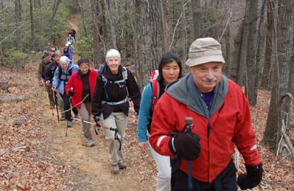
Photos by Ted Conners Mild weather and winter views, an excellent combination at any time, were particularly welcome after the experiences of the past few Wednesdays. Twenty-three hikers gathered at the FS picnic area outside of Old Fort and embarked on the thirty minute steady climb to Young’s Ridge. The winter views as we proceeded along the ridge were a bit hazy but excellent nonetheless: the curve of the Blue Ridge and the distant piedmont to the south and the Craggies, Blacks, and Blue Ridge to the north. We also had glimpses of the history of changing transportation in the mountains: I-40 climbing the escarpment to our left and old US 70, with its newly paved bicycle path, to our right – but we felt well removed from both. Part of our group lunched at the top of Kitsuma Peak while the rest continued down to the overlook with its view westward over the Swannanoa valley. After a very leisurely lunch, we returned by the same trail. It was another good day.--Joe Burchfield WEDNESDAY NO. W0901-560 Mar. 4 Wednesday hike reports for the week in which an eNews is issued will appear in the following eNews--The editor.
All-day hikes submitted by Bruce Bente 692-0116, bbente@bellsouth.net . Driving distance is round-trip from Asheville. All Saturday and Sunday hikes assemble at Westgate Shopping Center near I-240 UNLESS OTHERWISE NOTED. Half Day hikes submitted by Lucy Prim 828-693-6580 lucette32@mchsi.com. Wednesday Hikes are submitted by Charlie Ferguson, 828-398-0213 ccf108@gmail.com and Ann Gleason, 828-859-9387, gleason.ann@gmail.com . The meeting place for each hike will be designated by the hike leader and will appear in the hike description.
Driving mileage will be listed, round trip, from the first designated meeting place. |