|
OVERNIGHT NO. A0902-645 June 21
Gregory Bald via Gregory Ridge *9:00 AM
Hike 11.4, Drive 250, 3500 ft. ascent, Rated A-AA+
Cindy McJunkin, 828-712-9646, mcjfive@aol.com
900M *This hike will depart from the Cades Cove Visitor Center at 9:00 AM. The leader will reserve a 20-person group campsite at Cades Cove for Saturday night.
Contact her to reserve your space and for details about meeting place and tentsites. The hike will climb Gregory Ridge, one of the finest hikes in the Smokies, through old growth forest and virgin Tulip trees. The hike is timed to coincide with the magnificent bloom of flame azaleas on the summit of Gregory Bald. Panoramic views at
higher elevations. Topo: Cades Cove; also Nat’l. Geo. GSMNP map #229
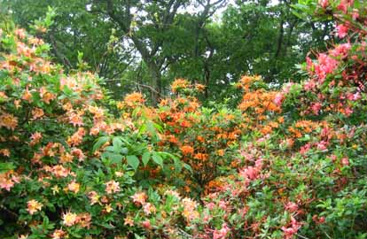 
Some hikes are worth a long drive, and climbing Gregory Bald is one of the Smokies' finest in late June. Nineteen of us gathered at Cades Cove Saturday
the 20th and pitched tents, shared some good things to eat and drink, and appreciated a nice campfire.
Sunday morning started with thunder and rain, so we had breakfast under the pavilion and by lantern light. Lenny, Janet, Tom, and Bob extended the
original hike for their goal of walking 900 miles of the Smokies, so they took off up the Gregory Bald trail for a head start. Paul and Jacob chose to
go up and down the same route, so they set out on their own. The rest of us followed, picking our steps through the muddy trail. The rain and fog stayed
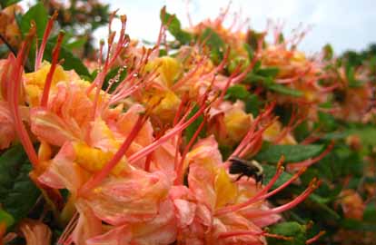
with us, obscuring our views from the top, but the azaleas weren't disappointing. We found red, orange, yellow, white, pink, and other colors in between.
While we were putting our packs back on to go back down, a doe ran through the grass beside us.
We completed our loop by way of Gregory Ridge Trail, and the fog began to lift, giving us some views of the valleys from the ridge. The sun and humidity
were intense, so we were ready to splash into Forge Creek and cool off. We left via Parsons Branch, a one way exit that terminates below Fontana Dam
and stopped off at the Jarrett House for a family style dinneer--Cindy McJunkin
SATURDAY NO. A0902-646 June 27
Mt. Noble Lookout Tower *8:30 AM
Hike 8, Drive 110, 1800 ft. ascent, Rated B-A
Peter Barr, 704-941-9296, pjbarr@unc.edu
900M, LTC *Note later start time. Starting from the Oconaluftee Indian Village in Cherokee, we will hike up the steep Mt. Noble trail to its lookout tower.
After enjoying the views, we’ll walk the gravel Adams Creek Rd. and a 0.5 mile manway up to the GSMNP boundary. There we’ll intersect the Mingus
Creek Trail and descend to its end with a visit to Mingus Mill. Short car shuttle. Second meeting place: back of Maggie Valley P.O. parking lot on
US 19 at 9:00 AM, but contact leader first. Topo: Smokemont; also Nat’l. Geo. GSMNP map #229 and Hiking NC Lookout Towers, pg. 127
ALL DAY NO. A0902-215 June 28
Mt. Cammerer via Low Gap and Lower Cammerer Trails *7:30 AM
Hike 15.5, Drive 140, 2600 ft. ascent, Rated AA-AA
Carroll Koepplinger, 828-667-0723, carrollkoepp@bellsouth.net
900M, LTC *Note earlier starting time. This beautiful hike from Cosby campground will ascend to the AT, then follow the AT to Mt. Cammerer. After
lunch and views from Mt. Cammerer, we will stroll down the Lower Mt. Cammerer Trail to our starting point.
Second meeting place: Pilot Truck Stop at exit 24 off I-40, at 8:00 AM. Topos: Luftee Knob and Hartford
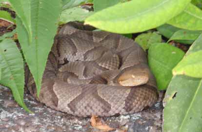
Photo by Carroll Koepplinger
Eight hikers took on the challenge of a 16 mile hike with eagerness. Leaving the trail head at 9:15 am for a steady uphill climb on the Low Gap Trail
to the A.T. and on to the Fire Lookout on Mt. Cammerer. After a nice reprise we continued back to the A.T. and on to the Lower Cammerer Loop trail
arriving back at the trail head at 5:10 pm where we enjoyed the precut ice cold watermelon brought by the hike leader.
We had one new first time hiker with CMC, welcome Melissa! Lisa is now the designated Snake Charmer for CMC! Sitting on rock with a shrub
enjoying lunch until someone pointed out that there was a copperhead rattle snake under the shrub and within 12 inches or less from Lisa.
She did move quit rapidly but the snake must have decided that Lisa was OK!! (see attached picture).
Weather was a little warm 70’s to 80’s and humid the cool breezes were helpful. No Rain!--Carroll Koepplinger
--Back to Top
Half Day Sunday
HALF-DAY NO. H0902-403 June 21
DuPont Forest – Reasonover Trail *12:15 PM
Hike 6, Drive 80, Rated B-C
Nonmembers, call leader, Lucy Prim, 828-693-6580, 32lucette@gmail.com
*Note early start time. Meet at Westgate at 12:15 PM to form car pools, and meet leader at Hooker Falls Parking lot in DuPont Forest at 1:00 PM.
This pleasant loop hike in the DuPont Forest includes the Fawn Lake, Corn Mills Shoals, Bridal Veil Falls, Lake Julian and Reasonover Creek Trails
and features views of small waterfalls.*
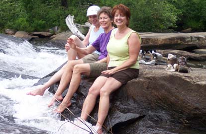
Photo by Lucy Prim
We had a very nice hike along Reasonover Trail yesterday. Fourteen of us started our hike along Reasonover Trail from Fawn Lake Parking lot.
It was a lovely warm day, not nearly as hot as the weatherman had predicted, thank goodness. The colors reflected on Lake Julia, so soft and silvery,
were a delight to see. As we walked on toward the falls, the Forest Ranger drove by in a truck and he paused for a bit to answer our questions about
the curious rustified buildings beside Lake Julia. He said they'd been buildings used by an old girls' camp many years ago. The old dining hall is in quite
a sad state now, but it must have been a place of such happy times back in the old days. We walked on to Bridal Veil Falls and had our snack on
the nice flat rocks at the foot of the falls. A big ominous looking cloud to the east appeared to be coming closer by the minute, so we put our shoes
back on and started on our way. On Airstrip Trail, just as we were beginning to feel a bit too warm , a nice little rain cooled us off.
Soon we were back to the cars and everybody went on home.--Lucy Prim
HALF-DAY No. H0902-453 June 28
Max Patch Ramble *12:30 PM
Hike 5.5, Drive 104, 800 ft. ascent, Rated B-C
Nonmembers, call leader, Gail Lamb, 828-350-0450, galmb46@aol.com
*Note early start time. Awesome panoramic views and summer wildflowers make this moderate hike a favorite. We will go up Max Patch, then the
Buckeye Ridge Trail to the Appalachian Trail. This will take us north through meadows, woods and across a small stream. We will break at the AT
shelter and return on the AT. Second meeting place: Pilot Truck Stop off I-40 at exit 24 at 1:00 PM.
--Back to Top
WEDNESDAY NO. W0902-566 June 17
The Roans *8:30 AM
Hike 8, Drive130, 1000 ft. ascent, Rated B-C
Adrian Lotherington, 828-484-9132, jaloth@charter.net
SB6K *Only meeting place: Rose’s car park (opposite McDonald’s), Exit 19B off I-26, in Weaverville. This in-and-out hike features superb views.
From Carver’s Gap we go over Jane Bald and Round Bald, to 6160 ft. Grassy Ridge Bald. These balds are rare and beautiful ecosystems.
Hopefully we will hit the time when we will walk among the magnificent mounds of Rhododendrons. If time allows we will drive to the gardens
(small fee) and walk ½ mile to see the great view from 6267 ft. Roan High Bluff.
WEDNESDAY NO. W0902-375 June 24
AT: Sams Gap to Rice Gap 9:00 AM
Hike 7.5, Drive 60, 1200 ft. ascent, Rated B-B
Charlie Ferguson, 828-625-2677, ccf108@gmail.com
An in-and-out hike, on the AT, in the beautiful open forest from Sams Gap to Rice Gap. We'll lunch at the Hog Back Ridge shelter. Topo: Sams Gap
 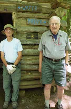
Photos by Charlie Ferguson and Ashok Kudva
Thirty four hikers converged on Sam's Gap from many directions. This hike was mostly a nice walk in the woods. We divided into two groups,
one slower and one faster. Adrian was appointed to lead the slower group. We started up ("south") on the AT, a gradual 900 foot climb to where
the trail junction for the Hogback Ridge Shelter was. The faster group went on to Rice Gap. Part of the slower group went to the shelter for lunch
and the other part went toward Rice Gap. Rice Gap is a junction of two sections of the A.T. and 4 other trails, mostly used by ATVs (I'm not sure
if they are supposed to). On the way back from Rice Gap, the two groups met and headed back to the shelter for lunch. Part way back some
people decide to stop and have lunch on the trail while the rest of the group went back to the shelter. A few stayed at the trail junction to make
sure that no one got lost (hard to do on this part of the A.T.). The slower group got started back early. During a break the faster group passed
and got back to the cars about 5 minutes before the slow ones. There were a few wildflowers. We had great weather - the temperature was
moderate with a bit of a breeze - I didn't charge extra for that. A strong recommendation for hike leaders: resist the tendency to split the hiking
groups further than necessary.--Charlie Ferguson
WEDNESDAY NO. W0903-471 July 1
Wagon Road Gap,
MST to Big East Fork *8:00 AM
Hike 9, Drive 95, 1500 ft. ascent, Rated A-A
Tom Sanders, 828-252-6327, tomary.avl@gmail.com
P400 Starting at Wagon Road Gap, we will follow the MST south to the connector to the Big East Fork Trail and follow that down to US 276. Short car shuttle.
Wilderness area hike, limited to ten hikers—call leader for reservations.
Second meeting place: Cold Mtn. overlook (BRP M.P. 412) at 8:35 AM. Topo: Shining Rock; also NatGeo map #780
Reports for Wednesday hikes during the eNews publication week will appear in the following eNews--The Editor.
--Back to Top
All-day hikes submitted by Bruce Bente 692-0116, bbente@bellsouth.net . Driving distance is round-trip from Asheville.
All Saturday and Sunday hikes assemble at Westgate Shopping Center near I-240 UNLESS OTHERWISE NOTED.
Half Day hikes submitted by Lucy Prim 828-693-6580 lucette32@mchsi.com.
Wednesday Hikes are submitted by Charlie Ferguson, 828-398-0213 ccf108@gmail.com and Ann Gleason, 828-859-9387,
gleason.ann@gmail.com .
The meeting place for each hike will be designated by the hike leader and will appear in the hike description.
Driving mileage will be listed, round trip,
from the first designated meeting place.
Leaders: Mail please mail your sign-up sheets. Meet at Westgate unless otherwise noted.
|
