All Day Saturday & Sunday
BACKPACK NO. B0904-188 Nov. 6 - 8
Clingmans Dome to Mingus Mill *7:30 AM
Hike 26, Drive 150, 5500 ft. ascent, 9000 ft. descent, Rated AA+-AA+
Paul Benson, 828-251-1909, pdbenson@charter.net
SB6K, 900M *Note earlier start time. This two-night, three-day backpack will follow the MST from Clingmans Dome to Mingus Mill near US 441. Stay at campsite #54 on Deep Creek the first night and #52 near Newton Bald the next night. The hike is strenuous and limited to experienced backpackers, limited to a group size of 8. Hikers must contact leader to reserve a space. *Meeting places: meeting place(s) to be arranged with leader. Topos: Clingmans Dome, Smokemont; also NatGeo map #229
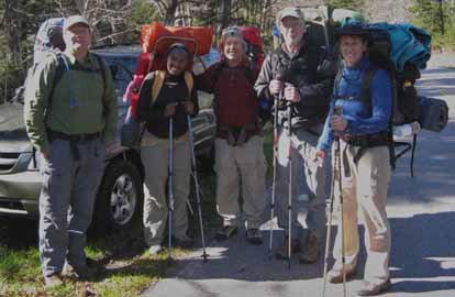
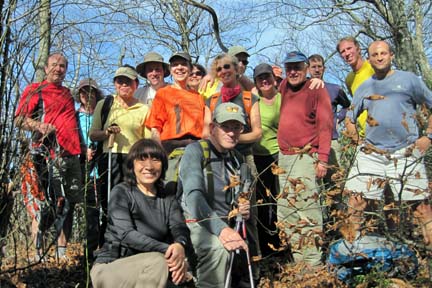
Photo by Paul Benson
Our group of 5, including two first time backpackers, convened bright and early at Westgate excited about the prospect of spending a long weekend in the woods under ideal weather conditions – warm, sunny days and cool nights.
The first segment of the hike was 5 miles down the Fork Ridge trail to the headwaters of Deep Creek. The trail was covered with damp leaves, narrow and steep in places. Unfortunately, one of us took a tumble and sustained a serious cut as a result. We decided it was too late in the day to hike the victim out, so we made camp earlier than we had planned at campsite 53 instead of 54. By the way, crossing Deep Creek just before reaching campsite 53 was a challenge giving one of us a pretty good soaking after a slip. In spite of the day’s difficulties, we all enjoyed the beautiful campsite which we had all to ourselves.
Saturday dawned cold and clear. Our victim decided he was ok to hike out on his own via the shortest possible route (Thomas Divide trail) and hitchhike to his car (which we had parked at the Mingus Creek trailhead – the end of our intended hike). Since we had lost our shuttle vehicle, we decided to reroute the trip to loop back to our starting point. We then headed down the beautiful Deep Creek trail to the scariest log bridge crossing I’ve ever done – a high log over a deep fast creek and the log was tilted with no handrail. We all made it across without incident and headed up the Pole Road Creek trail where we had another half dozen or so very challenging crossings. Finally we climbed above the creek and reached the crest of Noland Divide where we made camp near Upper Sassafras Gap and enjoyed a beautiful evening. On Sunday we enjoyed an early sunrise from our ridge top perch, and hiked up a very pretty Noland Divide trail to the Clingmans Dome Road. From there we got on the A.T. and hiked over Mt Collins back to our car at the Fork Ridge trailhead.
For the four of us that finished the hike, the experience was a wonderful adventure. We thoroughly enjoyed each other’s company and the special beauty of one of the more remote high elevation sections of the Smoky Mountains. We felt very concerned about our injured companion who we later learned was able to hitch a ride back to his car and get medical attention in Haywood County.
See pictures at: http://outdoors.webshots.com/album/575451187PCLPwf --Paul Benson
ALL DAY NO. A0904-254 Nov. 8
Green Knob via Snooks Nose 8:00 AM
Hike 9, Drive 65, 3600 ft. ascent, Rated A-AA+
Carroll Koepplinger, 828-667-0723, carrollkoepp@bellsouth.net
This strenuous trip from Curtis Creek climbs up, over, and above the Blue Ridge Parkway to the Green Knob fire tower. Great views along the way as well as at the lunch stop on the summit of Green Knob. Second meeting place: Ingles parking lot adjacent to McDonalds at Exit 64 of I-40 at 8:20 AM. Topo: Old Fort
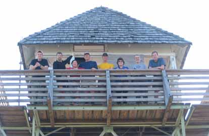 
Photos by Lisa Hart and Bruce Bente
Ten hikers enjoyed the beautiful warm and sunny hike up to Green Knob Fire Tower (pictured) via a stop on the 360 degree viewtop of Snook's Nose. The out-and-back trail starts with an incredibly steep and slippery (all the fluffy leaves on the ground) slope, with the finish even tougher. Lots of nice breaks and a very blue sky. Lunch was held in the Green Knob Fire Tower and sushi was served. We even spotted a small fire from the fire tower. As always, lots of great conversation!--Lisa Hart (substitute hike leader for the recovering Carroll Koepplinger)
SATURDAY No. A0904-578 Nov. 14
Flat Laurel Creek, Little Sam Knob, MST Loop *10:00 AM
Hike 7.5, Drive 80, 1000 ft. ascent, Rated B-B
Marcia Bromberg, 828-505-0471, mwbromberg@yahoo.com
P400 *Note later start time. This is a pleasant loop trail with views of Big Sam Knob, Fork Ridge and Flat Laurel Creek. We’ll begin on the Flat Laurel Creek Trail, which ascends gradually until we are hiking next to the creek, where we will stop for lunch. Little Sam Knob Trail, with views of Little Sam Knob and Sam Knob, connects to the MST. A one-mile side trip to Devils Courthouse will offer good views before we return on the MST to our cars. Bear hunting season - hike in groups and wear bright orange.
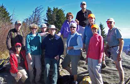
Photo by Marcia Bromberg
Due to the recent rain creating challenging stream crossings we made a last minute change to the hike plans for Saturday. Instead the 11 hikers began at NC 215 and hiked east on the MST to just before Silvermine Bald and back, with a side trip to Devil's Courthouse for lunch. With the beautiful warm, sunny weather the hikers enjoyed long stops there, at the return point and at the rock where Little Sam Knob trail meets the MST (named or renamed Marcia's rock). The picture shows the happy hikers at Devil's Courthouse.--Marcia Bromberg
ALL DAY NO. A0904-142 Nov. 15
Jerry Miller Trail to AT to Fork Ridge Trail *8:00 AM
Hike 9.5, Drive 92, 3300 ft. ascent, Rated A-AA+
Tish Desjardins, 828-656-2191, desraylet@aol.com
*Meet at Westgate at 8:00AM to form carpools, and meet leader at US25/NC208 intersection at 8:45AM. *After the hike there will be a potluck supper in the nearby Bear River Community Lodge. Hikers are requested to contribute food for the supper. Food will be taken to a refrigerator before the hike. Please phone the leader to coordinate what food to bring. We’ll hike up the Jerry Miller Trail to Bearwallow Gap and right on the AT to Andrew Johnson Mountain. Right on the Fork Ridge Trail down to FS 111 and a short walk to the cars. Topo: Greystone; also NatGeo map #782
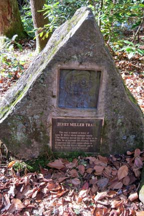 
Photos by Danny Bernstein
There were seventeen of us on this hike today. We started at 10:00 on the Jerry Miller trail and after the big climb, we were on the A.T. at Bearwallow Gap at 12:25. It was a clear, warm, beautiful sunny day and the views were outstanding on the ridge at Firescald, a perfect lunch spot. Tom Sanders gave us some history on the relocating of the A.T. at this section, specifically all the rock work that was involved. It took five years to complete it. We continued northbound on the A.T. and over Andrew Johnson mountain and entered the Fork Ridge Trail. We got back to the cars at 4:00. We enjoyed wine, appetizers, and potluck dinner afterward at the community clubhouse where I live. A perfect day!--Tish Desjardins
--Back to Top
Half Day Sunday
HALF-DAY NO. H0904-101 Nov. 8
Lower Laurel River *1:00 PM
Hike 6 miles, Drive 60, Rated B-C
Nonmembers, call leader, Tom Sanders, 828-252-6327, tomary.avl@gmail.com
*Note early start time. This in-and out hike near Hot Springs follows a beautiful rushing stream to the historic logging camp at Runion.
Twenty-one people turned out for this hike on a beautiful late fall day. It was clear, sunny and the Laurel River, enhanced by recent rains, was high and spectacular. This was a very diverse group, including at least a couple of people who hadn't hiked with us before. Conscious that dark is coming early, we met at Westgate at 1:00. I have always thought this was a 6 mile roundtrip, but Carroll on his GPS got it at 8. We had a snack on reaching the French Broad and were back at our cars at 5:15. By 5:45 it was dark. This is an excellent hike for half-day Sunday. It is level both in and out, but we did a brisk pace, and that makes it a good workout. It is the kind of hike when you have company, people who want to hike, but aren't in great shape. The Laurel is one of WNC's most beautiful streams, and up above are beautiful bluffs. It's flexible because one can go in any distance and then return.--Tom Sanders
HALF-DAY NO. H0904-325 Nov. 15
Tanyard Gap to Rich Mountain *12:30 PM
Hike 5, Drive 72, 1360 ft. Ascent, Rated C-B
Nonmembers, call leader, Jorge Munoz, 828-658-0606, jmunoz@buncombe.main.nc.us
*Note early start time. After a moderate climb on the Appalachian Trail, we will be rewarded with an outstanding view of the Hot Springs area from the fire tower.
--Back to Top
WEDNESDAY NO. W0904-190 Oct. 7
MST: Mt. Mitchell to Balsam Gap * 8:00 AM
Hike 9.5, Drive: 80, 1700 ft. ascent, Rated A-A
Mary Beth Gwynn: 828-545-6487 (cell) or 828-254-2042 (home). mbgcmc@gmail.com
*Only meeting place will be the back parking lot of Folk Art Center. Please note: Much of the trail is on large moss covered rocks, lovely, but potentially slippery if wet. Appropriate shoes and perhaps poles are advised. This is a particularly beautiful section of the MST with spectacular views from our lunch spot. Car shuttle. Topos: Mt. Mitchell, Montreat; also PNF South Toe River, Mt. Mitchell & Big Ivy Trail Map Deer bow hunting season - hike in groups and wear bright orange.
Six hikers – five women and Cliff - started off on a moist, blustery, heavily fogged morning from the Ranger Station at Mt. Mitchell State Park. One woman traveled 2.5 hours from Charlotte for the hike. Noting the gender division, Cliff volunteered to sweep, saying he was planning to keep a low profile in the group and his ears open. We decided to leave from the Ranger Station rather than from the summit because it had rained and the descent from the top would be unusually slippery. It turned out to be a good call for a beautiful hike on a beautiful day. Sparkling water sprayed off of rocks, deep violet gentian bloomed along the trail and the forest was lush with mosses and ferns. Although the sky was a bright blue we huddled behind the rock outcropping where we had planned a 180 degree view during lunch because the winds gusts were so strong. Five and a half hours after we started, we came to the car we’d left at Balsam Gap, having hiked 9.25 miles and snacked on the last fat blueberries of the season.--Mary Beth Gwynn
WEDNESDAY NO. W0904-276 Nov. 4
Street Gap to Big Bald 8:30 AM
Hike 9, Drive 80, 2300 ft. ascent, Rated B-AA
Paula Massey, 828 299-0226 massey.paula@gmail.com
In-and-out hike on the Appalachian Trail, heading north. We will have panoramic views of the Blacks, Smokies and other ranges in WNC and TN. once we reach Big Bald as well as the Wolf Laurel area enroute. Topos: Sams Gap, Bald Creek Deer & Bear hunting season - hike in groups and wear bright orange.
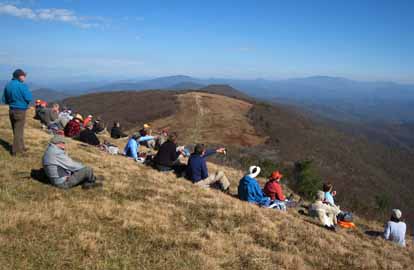
Photo by Charlie Ferguson
Thirty hikers enjoyed a beautiful day on the trail. We started from Street Gap at about 10 A.M. and arrived on top of Big Bald by 12:15 P.M. We enjoyed fantastic views and each other's company for over 45 minutes. The weather was sunny and in the mid 50's. We could view the Smokies, Mt. Mitchell and the Blacks, Table Rock, Hawks Bill, Roan Mt., Big and Little Hump mountains, Pisgah and a glimpse of Grandfather Mountain. We returned on the same trail and arrived at our cars about 3:30. All agreed that it was a glorious day out in the woods. We thank Barth Brooker and his trail crew for their recent tree-clearing work on the AT. Upon arriving at home I reported to Paula Massey, whom could not lead the hike due to recovering from a wrist fracture sustained from a bicycle accident on October 22. Paula would love to hear from any of her fellow hikers during her convalescence. Her e-mail address is massey.paula@gmail.com.--Jay Bretz
WEDNESDAY NO. W0904-673 Nov. 11
Coontree - Pink Beds *8:30 AM
Hike 9.5, Drive 80, 2200 ft. ascent, Rated A-AA
Ashok Kudva, 828-698-7119, Cell: 828-674-1374, ashok.kudva@gmail.com
P400 *Meet at Westgate at 8:30 AM to form carpools, and meet leader at Pisgah Ranger Station at 9:05 AM. From the right branch of Coontree Loop we will climb up to and on Bennett Gap Trail to our lunch spot with a view of Looking Glass Rock. Proceeding on the Buckwheat Knob Trail to Club Gap, we will approach Rich Mountain and descend via Soapstone Ridge to Barnett Branch Trail. We will go over the Barnett Branch Boardwalk, recently built by CMC‘s Friday Pisgah crew, to the cars at the Pink Beds parking lot. Car shuttle. Topo: Pisgah Forest; also NatGeo map #780 Deer & Bear hunting season - hike in groups and wear bright orange.
This was the second day of continuous rain caused by Hurricane Ida. Nobody but me showed up at the Pisgah Ranger Station, I cancelled the hike and went home dry.
We will do this hike either late fall or early March next year with no foliage on trees to enjoy 360 degree mountain views while descending the ridges of Rich Mountain, Buckwheat Knob and Bennett Gap trails. It will start at Pink Beds and end at Coontree Picnic Area. Charlie has put the GPS track in the hike database.--Ashok Kudva
Reports for Wednesday hikes during the eNews publication week will appear in the following eNews--The Editor.
--Back to Top
All-day hikes submitted by Bruce Bente 692-0116, bbente@bellsouth.net . Driving distance is round-trip from Asheville. All Saturday and Sunday hikes assemble at Westgate Shopping Center near I-240 UNLESS OTHERWISE NOTED.
Half Day hikes submitted by Lucy Prim 828-693-6580 lucette32@mchsi.com.
Wednesday Hikes are submitted by Charlie Ferguson, 828-398-0213 ccf108@gmail.com and Ann Gleason, 828-859-9387,
gleason.ann@gmail.com .
The meeting place for each hike will be designated by the hike leader and appears in the hike description.
Driving mileage is round trip, based on the first designated meeting place. Meet at Westgate unless otherwise noted.
|
