All Day Saturday & Sunday
ALL DAY NO. A0904-563 Dec. 6
Palmetto Trail: Poinsett Passage and Blue Wall Preserve. *8:30 AM
(strenuous)
Hike 10, Drive 100, 1200 ft. or 2400 ascent, Rated A-B or A-AA
Charlie Ferguson, 828-625-2677, ccf108@gmail.com / Ann Gleason, 828-859-9387, gleason.ann@gmail.com
*Note later start time. Come hike the Poinsett Passage of the Palmetto Trail. This stretch climbs along the NC / SC border and NW ridge of the Greenville water shed. The trail travels up and down the ridge through wilderness that had been closed to the public for decades, then descends to the Vaughn’s Gap parking area behind Lake Lanier. Key swap. Second meeting place: Saluda Truck Stop, Texaco station at Exit 59 off I-26 at 9:10 AM. Topo: Saluda
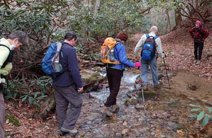 
Photos by Ted Connors and Charlie Ferguson
I started my group of 12 on the Saluda end and we key swapped about mid-way. The day was cold but there was not breezy and it proved to be a great day for hiking. The trail on the Pointsett passage is showing a lot of wild pig upheaval in sections- but it is a very impressively built trail over all.--Ann Gleason
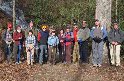
This hike is on a 9.5 mile section of the Palmetto Trail, South Carolinas version of our Mountains-to-Sea Trail. Fourteen hikers departed Saluda for the trailhead at the Blue Wall Preserve, which is owned by the South Carolina Nature Conservancy and open to the public for hikers. We walked for about a mile on relatively flat trail past two ponds to a small cascade for a photo op. Another short flat walk to the Blue Wall Preserve part of the trail. Faster hikers were let loose to hike to the top of Vaughn's Gap, a 3-mile 1,500 foot climb. Although "no one wanted to race", Lisa, our marathon runner got to the top first. Everyone else was strung out for another 10 minutes or so. Our next trail is the Poinsett Passage, still part of the Palmetto Trail. Parts of this trail goes along part of the boundary, along some ridgelines that define the watershed of the Poinsett Watershed which feeds the North Saluda River, which fills the North Saluda Reservior, also know as the Poinsett Reservoir.
The reservoir is a water supply for Greenville, SC. The first part of the trail is a 2 mile dirt road, including a 500 foot climb over Rocky Spur and down to a left turn onto a foottrail along Brushy Ridge, a boundary between North and South Carolina. Part way along the road we met the 12 CMC hikers that started at Orchard Lake and chatted awhile. We were waiting to meet them before we ate, but they had already eaten so we walked to the end of the road and sat down for lunch. The hike along Brushy Ridge and then past Melrose Lake and down to Orchard Lake was mostly easy downhill with one short steep uphill. This section of the Palmetto Trail actually ends in North Carolina where we found our cars, rested a bit and headed back to Saluda. The weather was perfect for this hike, starting cool for the difficult hike uphill and warming up a bit for the rest of the more moderate hike. We had a few new hikers and some from quite a distance away. It was nice to trade stories and catch up on each others goings on.--Charlie Ferguson
ALL DAY NO. A0904-278 Dec. 6
Kitsuma Peak *8:30 AM
(moderate)
Hike 9, Drive 60, 1700 ft. ascent, Rated A-A
Danny Bernstein, 828-236-0192, danny@hikertohiker.com
*Note later start time. This joint hike with the Carolina Berg Wanderers (Charlotte) will ascend Young’s Ridge and offers great views of Greybeard, Green Knob and the Mt. Mitchell area. We will return on old US 70, now blocked off to traffic, where we will see the railroad and numerous tunnel portals. The hike is limited to 10 CMC and 10 Carolina Berg Wanderer hikers, so please contact leader to reserve your space. Second meeting place: McDonald’s parking lot at Exit 73 (NOT Exit 64) of I-40 at 9:00 AM. Topos: Old Fort, Black Mtn.
 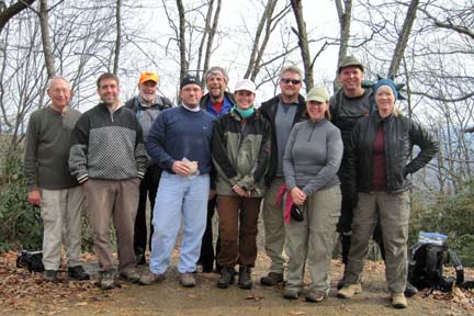
Photos by Danny Bernstein
There was lots of indecision about doing the hike because of the prediction of snow and rain on Saturday. But the hike went on and it was a good decision. The snow had left the area though several hikers cancelled out, afraid of the weather. But by the time, we met at the McDonald on I-40, exit 73, it was dry and cold. We had 11 people - six CMC folks, and five from the Carolina Berg Wanderers.
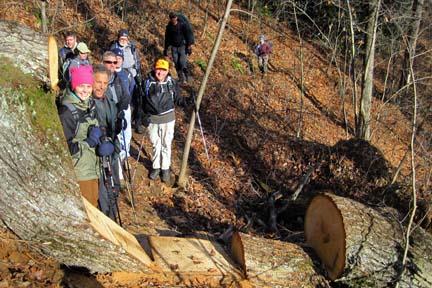
On my scout, I had found a huge blowdown near the beginning of the hike and called the Grandfather District of Pisgah National Forest. I asked them to cut that tree and they did. See above. Thank you U.S. Forest Service.
We had lunch on top of Kitsuma Peak - no wind. The railroad history fascinated some and others just walked on the road without noticing the railroad line and the many tunnels. But we all noticed the new blowdown on Point Lookout Trail. I'm not going to bother to call the Forest Service on that one. The bikers will be more affected and get to them.
After the hike, we all drove to Andrews Geyser. It was spewing out water just fine. It's an artificial geyser; Western North Carolina doesn't have natural geysers.--Danny Bernstein
SATURDAY NO. A0904-423 Dec. 12
Pilot Rock, Laurel Mtn., Slate Rock Creek Trails *10:00 AM
Hike 7, Drive 90, 1450 ft. ascent, Rated B-B
Dave Wetmore, 828-884-7296, dwetmore@citcom.net
P400 *Note later start time. Meet at Westgate at 10:00 AM to form carpools, and meet leader at Pisgah Ranger Station at 10:35 AM. We’ll hike up the Slate Rock Creek Trail, one of the gems of Pisgah Nat’l. Forest., and then a connector up to the Laurel Mtn. Trail, which we’ll follow for a while. We’ll turn downhill on the Pilot Rock Trail, stopping to enjoy the views along the way. Short car shuttle. Topo: Dunsmore Mtn.; also NatGeo map #780 Deer hunting season - hike in groups and wear bright orange.
Ten hikers braved a cold and cloudy day and a forecast of afternoon sleet to go on this hike. We saw numerous pickups parked on Yellow Gap road and at least two gunshots were heard, but we saw no hunters and no deer. The weather on the trip varied greatly, pleasantly cool at lower elevations, unpleasantly cool at higher elevations and cold on the windy ridgeline of Laurel Mountain.--Dave Wetmore
ALL DAY NO. A0904-671 Dec. 13
Raven Cliff Falls – Naturaland Trust *8:00 AM
Hike 12, Drive 100, 2000 ft. ascent, Rated A-AA
Jeff McGurk, 864-801-1314, jbsbestfan@hotmail.com
*Meet at Westgate at 8:00 AM to form carpools, stop at Bi-Lo in Pisgah Forest at 8:35 AM to meet more hikers, and meet leader at Caesar’s Head S.P. visitor Center at 9:00 AM. This new hike in Caesar’s Head State Park will go from US 276 to Raven Cliff Falls, then double back and follow the Foothills and Naturaland Trust trails back to US 276. There will be a cable crossing of Matthews Creek. Short car shuttle. Topos: Table Rock, Cleveland; also Mtn. Bridge Wilderness Area map
--Back to Top
Half Day Sunday
HALF-DAY NO. H0904-525 Dec. 6
DuPont Forest: Corn Mill Shoals Parking Lot #2 *12:00 PM
Hike 4, Drive 94, Rated C-C
Nonmembers, call leader, Becky Elston, 828-749-1886, belston@cytechusa.com
*Note early start time. Meet at Westgate at 12:00 PM to form carpools. Meet leader at Hooker Falls parking lot at 12:45 PM. A pleasant hike over several trails up and over the granite slabs of Cedar Mountain with a break at the top of Bridal Veil Falls.
Had a great but cold day up and over Cedar Rock at Dupont Forest. Couldn't go to the top of Bridal Veil Falls as we would have had to cross over the private land because it is patrolled, and currently in the middle of an industrial cleanup. So we visited the shoals for our break. Nice group.--Becky Elston
HALF-DAY No. H0904-295 Dec. 13
Pump Gap Loop *12:30 PM
Hike 5.5, Drive 80, 1200 ft. Ascent, Rated C-B
Nonmembers, call leader, Jorge Munoz, 828-658-0606, jmunoz@buncombe.main.nc.us
*Note early start time. From Silvermine trailhead in Hot Springs we will have a good climb to the ridge. We will visit an old mountain cemetery, cross the AT and return on Pump Gap Trail.
--Back to Top
WEDNESDAY NO. W0904-053 Dec. 2
East Fork Pigeon River *8:30 AM
Hike 7.5, Drive 74, 1200 ft. ascent, Rated B-B
Barbara Morgan, 828-738-3395, bcmorg@hughes.net
P400 Wilderness area, limit 10; contact leader for reservation. A stroll along one of WNC's most beautiful streams, the East Fork of the Pigeon River, which is often spectacular in the winter. We will ascend to Dark Prong for lunch and then return. Second meeting place: Big East parking area on US 276, north of BRP at 9:15 AM Topo: Shining Rock; also NatGeo map #780
WEDNESDAY NO. W0904-492 Dec. 9
Cookie Hike, Bent Creek Ramble *8:30 AM
Hike 7, Drive 10, 1200 ft. ascent, Rated B-B
Ken and Carol Deal, 828-281-4530, cnkdeal@charter.net
P400 *ONLY MEETING PLACE: Ingles parking lot on NC 191 across from Biltmore Square Mall. Moderate loop hike in the Bent Creek area. We will start from the parking area for Cold Knob Road (479H off Bent Creek Road beyond Lake Powhatan). Using a variety of short sections of trails, we will hike up to the MST, follow it past Sleepy Gap, and descend by the Stambaugh Trail to the Lake Powhatan picnic area for lunch and a cookie feast. Bring cookies to share with lunch. The afternoon walk back to the cars is approximately 2 miles. Topo: Asheville; also NatGeo map #780 and Bent Creek Trail Map. Deer hunting season - hike in groups and wear bright orange.
ALTERNATE HIKE
WEDNESDAY NO. W0904-i Dec. 9
Cookie Hike, shorter version *10:00 AM
Hike 4, Drive 10, Rated C-C
Sherman Stambaugh, 828-254-1736
*ONLY MEETING PLACE: Ingles parking lot on NC 191 across from Biltmore Square Mall. Starting from the Rice Pinnacle parking area, we will take the Hard Times Connector to the Lake Powhatan picnic area to meet the other group for lunch and to share cookies. After lunch we will return to the cars. Deer hunting season - hike in groups and wear bright orange.
WEDNESDAY NO. W0904-479 Dec. 16
Kagel Mtn. *8:30 AM
Hike 9, Drive 80, 1100 ft. ascent, Rated B-B
Charlie Ferguson, 828-625-2677, ccf108@gmail.com
P400 *Meet at Westgate at 8:30 AM to form carpools, and meet leader at Bi-Lo in Pisgah Forest at 9:05 AM. This loop hike will start from Catheys Creek Rd. and follow an overgrown forest road to the Art Loeb Trail, with lunch at the Butter Gap shelter. We’ll return on another trail for variety. Nice winter views. Topos: Rosman, Shining Rock; also Nat’l. Geo. map #780 Deer hunting season - hike in groups and wear bright orange.
Reports for Wednesday hikes during the eNews publication week will appear in the following eNews--The Editor.
--Back to Top
All-day hikes submitted by Bruce Bente 692-0116, bbente@bellsouth.net . Driving distance is round-trip from Asheville. All Saturday and Sunday hikes assemble at Westgate Shopping Center near I-240 UNLESS OTHERWISE NOTED.
Half Day hikes submitted by Lucy Prim 828-693-6580 lucette32@mchsi.com.
Wednesday Hikes are submitted by Charlie Ferguson, 828-398-0213 ccf108@gmail.com and Ann Gleason, 828-859-9387,
gleason.ann@gmail.com .
The meeting place for each hike will be designated by the hike leader and appears in the hike description.
Driving mileage is round trip, based on the first designated meeting place. Meet at Westgate unless otherwise noted.
|
