All Day Saturday & Sunday
NEW YEARS DAY NO. A1001-281 Jan. 1
Green River Gamelands *8:00 AM breakfast, 9:15 AM hike
Hike 6.5 or 8, Drive 70, 1300 or 1500 ft. ascent, Rated B-B
Bruce Bente, 828-692-0116, bbente@bellsouth.net
*Meet at Westgate at 7:30 AM to form carpools and meet leader at times above at the NE corner of the Cracker Barrel parking lot in Hendersonville (exit 53 on I-26). After breakfast, we’ll do our traditional New Year’s Day hike on a series of trails around the Green River Gamelands. We’ll hike down to and along the Green River, with a late lunch at the big rocks on the Green River, and then hike up and out on the Pulliam Creek trail. Short car shuttle. Topo: Cliffield Mtn.; also Map of the Green River Gamelands Trails
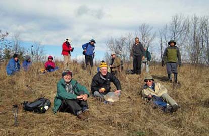 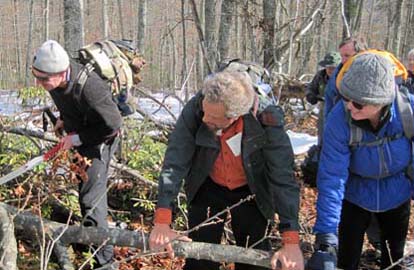
Photos by Danny Bernstein
For the first CMC hike of 2010, the anticipated condition of the trail (snow, ice, etc) strongly suggested not doing the scheduled hike. Fourteen dedicated hikers showed up, so instead we did a "lollipop" hike from the trailhead at the end of Big Hungry Rd. First we went in on Long Ridge and Turkey Gut Trails, then looped back via Stairstep Falls Trail with a lunch stop at the open field above Loobie Clifs. After lunch it was back to our cars via Long Ridge Trail.--Bruce Bente
SUNDAY NO. A1001-276 Jan. 3
Street Gap to Big Bald 8:30 AM
Hike 8, Drive 80, 1700 ft. ascent, Rated B-A
Jay Bretz, 828-658-1220, jbretz1220@gmail.com
In-and-out hike on the Appalachian Trail, heading north. We will have panoramic views of the Blacks, Smokies and other ranges in WNC and TN. once we reach Big Bald as well as the Wolf Laurel area enroute. Topos: Sams Gap, Bald Creek
It was about 10 degrees at the start of the hike with windchills 5 to 10 degrees below zero. Six experienced hikers with plenty of clothing and myself decided to hike until we got cold. The forest service road up to Street Gap was too icy to drive to the trail head so we started the hike at Sam's Gap.
We started the hike on the leeward side of the ridge with snow levels on the trail of about two inches from a recent dusting. We made it to Streets Gap after passing through some deeper snow as we reached 4200 ft. on a grassy knoll before heading down to the gap. As we climbed up towards Big Bald we gradually ran into deeper snow(12-15") and colder conditions as we were then on the windy side of the ridge. Since the blazes were hard to follow at time due to blown snow on the trees and with the snow depth we were lucky and only made 2 minor deviations from the trail. I have been on this trail numerous times and even though I don't have a GPS there really wasn't a risk of getting lost.
We made it up the trail to where the powerlines for Wolfe Laurel cross and then some people were experiencing fatigue and cold issues. So we did not continue to Big Bald. We hiked quickly back towards the cars and as we descended we knew that everyone would be alright.
I estimate we hiked about 9 miles in some difficult conditions but we had a strong and experienced group. With the cold temperatures we were able to take only short breaks and had some issues keeping water unfrozen.
Overall, we had a good hike, enjoying nature's winter beauty. My caveat is that even excellent hikers need to be aware of wind chills of below 0 when hiking on the trails, especially if the trail will be in the wind much of the hike.--Jay Bretz
SUNDAY NO. A1001-186 Jan. 10
Little Pisgah Mountain 8:30 AM
Hike 9, Drive 36, 1500 ft. ascent, Rated B-B
Don Walton, 828-654-9904, donwalton@bellsouth.net
A pleasant hike, close to home for our coldest month. We’ll hike from Hickory Nut Gap through part of the Florence Preserve and up into an open meadow to the summit of Little Pisgah Mtn. If the weather is clear, the view doesn’t get any better. Topo: Bat Cave
One hiker showed up at Westgate to do the hike. We decided to cancel the scheduled hike and join another non scheduled hike getting ready to leave. This hike was a low altitude, out of the wind, Hot Springs Hot Tub hike that turned out to be an almost perfect day. The only hiccup was a fellow hiker fell and dislocated his shoulder but as we were hiking out to get help the shoulder suddenly went back in so we resumed our hike as planned.--Don Walton
--Back to Top
Half Day Sunday
HALF-DAY NO. H1001-685 Jan. 3
North Slope Loop Trail *12:30 PM
Hike 4.5, Drive 65, Rated C-C
Nonmembers, call leader, Lucy Prim, 828-693-6580, 32lucette@gmail.com
P400 *Form carpools at Westgate and meet hike leader at Pisgah Ranger Station, US 276 at 1:15 PM. A short pleasant hike starts at the Pisgah Ranger Station, goes up the North Slope Ridge, and back along the Davidson River.
HALF-DAY NO. H1001-434 Jan. 10
Laurel Mountain Trail *12:30 PM
Hike 5.4, Drive 40, 700 ft ascent, Rated C-C
Nonmembers, call leader, Greg Goodman, 828-684-9703, greggoodman@bellsouth.net
P400 *Form carpools at Westgate, and meet leader at the North Mills River parking area at 1:00 PM. This loop hike will start at FS 1206, go along a ridge trail toward Black Mountain, and return via the Laurel Mountain Trail. There should be good views of the Mills River Valley.
Cancelled due to snow.
--Back to Top
WEDNESDAY NO. W0904-652 Dec. 30
Devil Fork Gap to Rocky Fork Rd. *9:00 AM
Hike 7, Drive 80, 1300 ft. ascent, Rated B-B
Don Walton, 828-654-9904, donwalton@bellsouth.net
*Be prepared for possible wet stream crossings. This hike ventures into the new Rocky Fork Tract purchase of 10,000 acres near Flag Pond, TN. The first three miles of this hike is on the AT to Flint Gap Shelter and on to Flint Gap and the entry into the Rocky Fork Tract. This route is also the path of a surprise attack on an Indian Camp in the early 1800’s. Car shuttle. Topo: Flag Pond
The recent snow and rain made the probable water levels too high for the several stream crossings in the Rocky Fork Tract so the hike was changed to Florence Preserve to Little Pisgah Mtn. Eight hikers started to make our way to the Florence trail head. While driving up to the parking area above the Gerton Grocery store, we came around a curve and there was CMC members from Camden, SC Charlie and Alice Brice with Alice lying in the middle of the road. They had gotten their car stuck on the way to hike and while walking back down Alice fell on the ice and injured her shoulder. We helped comfort Alice while waiting for the ambulance to arrive.
After getting the car out and getting Alice safely on her way to the hospital, we prepared to start our hike. We started up the blue trail with about 9 other CMC alternate Wednesday hikers. If this trail is typical of our trails in this area, the heavy snow storm and the ice from the rain have made the trails a maze of thousands of broken branches many that will require chain sawing. This made the hike slow going until we got to the road to Little Pisgah. Then as we came out of the trees the road turned to almost solid, very hard ice, on the way up. We had lunch about a mile from the top, great views, then turned around and proceed back to the cars. It was a great day in the woods.--Don Walton
WEDNESDAY NO. W1001-438 Jan. 6
Rich Mountain, Round Top Trail and Lovers Leap 8:30 AM
Hike 9.5, Drive 70, 2200 ft. ascent, Rated B-AA
Tom Sanders, 828-252-6327, tomary.avl@gmail.com
LTC From Tanyard Gap we will go north on the AT to the beautiful views from Rich Mountain, then descend to Hot Springs via Round Top Ridge Trail, culminate the day with a short climb to Lover's Leap, and finish on the AT in Hot Springs. Second meeting place: Tanyard Gap at 9:15 AM. Topo: Hot Springs; also FS Hot Springs Harmon Den map; NatGeo map # 782
The schools were closed in Madison County, indicating that the roads were icy, and the temperature was 14 at Westgate, with a strong wind, and windchill about zero. Therefore I cancelled the hike. There were three people at Westgate. Two of them, from McDowell Co., decided to hike on the MST there, and the third, a young French woman who was involved in an insane project of visiting the US in winter by bus, I took downtown, showed her things, and left her at Malaprops where she could always get warm. --Tom Sanders
WEDNESDAY NO. W1001-677 Jan. 13
Swannanoa River/Warren Wilson College 8:30 AM
Hike 9, Drive 27, 100 ft. ascent, Rated B-C
Mary Beth Gwynn, 828-254-2042, Cell: 828-545-6487, mbgcmc@gmail.com
We hike along the Swannanoa River and on Dams Pasture trails passing through a bamboo grove and by the old dam. From the old dam we take Anthony’s Loop and return back to Owen Park where the hike began. Second meeting place: Owen Park at 8:50 AM. Topo: Oteen; also Warren Wilson College Trails Map
Reports for Wednesday hikes during the eNews publication week will appear in the following eNews--The Editor.
--Back to Top
All-day hikes submitted by Bruce Bente 692-0116, bbente@bellsouth.net . Driving distance is round-trip from Asheville. All Saturday and Sunday hikes assemble at Westgate Shopping Center near I-240 UNLESS OTHERWISE NOTED.
Half Day hikes submitted by Lucy Prim 828-693-6580 lucette32@mchsi.com.
Wednesday Hikes are submitted by Charlie Ferguson, 828-398-0213 ccf108@gmail.com and Ann Gleason, 828-859-9387,
gleason.ann@gmail.com .
The meeting place for each hike will be designated by the hike leader and appears in the hike description.
Driving mileage is round trip, based on the first designated meeting place. Meet at Westgate unless otherwise noted.
|
