All Day Saturday & Sunday
SUNDAY NO. A1002-691 Apr. 4
Upper Whitewater Falls – Round Mtn. Gap 9:00 AM
Hike 8, Drive 120, 1400 ft. ascent, Rated B-B
Marcia Bromberg, 828-505-0471, mwbromberg@yahoo.com
WC100 This new CMC hike will follow the Foothills Trail west from the Upper Whitewater Falls parking lot (small parking fee) to Round Mtn. Gap, then follow the Round Mtn. trail back to the waterfall overlook. From here we will take the Foothills Trail east, crossing the Whitewater River bridge and then turning uphill on a spur trail to the Bad Creek parking area. Short car shuttle. Second meeting place: Pisgah Forest Bi-Lo at 9:35 AM. Topos: Cashier, Reid; also NatGeo map #785
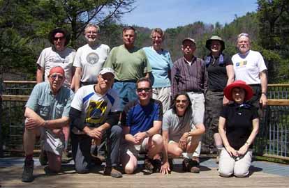
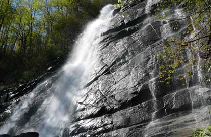
Photo by Marcia Bromberg
What a perfect day for a hike! Twelve hikers enjoyed discovering a new trail linking the Foothills Trail to Whitewater Falls. After lunch at the overlook where we enjoyed the view of the falls we hiked down to the river and scrambled up to the very high bridge crossing the Whitewater River. On the other side the hike followed the tumbling waters of the river to the next bridge where four hikers decided to take a side trip to see the lower Whitewater Falls while the other hikers cooled their feet in the river. We ended the day tired, but happy with our beautiful day.--Marcia Bromberg
SATURDAY NO. A1001-680 April 10 - Makeup hike due to cancellation of Feb. 27 hike - Note: No meeting at Westgate
Lost Cove in Tennessee 8:30 AM at Rose's
Hike 8, Drive 90, 2200 ft. ascent, Rated B-AA
Les and Catherine Love, 828-658-1489, lesrlove@charter.net
On this new CMC hike, we’ll explore the old settlement near the banks of the Nolichucky River that still has three houses standing and old cars in the yard. Optional supper at Farmer’s Daughter in Chuckey. 1st meeting place: Rose’s in Weaverville(Exit 19B off I-26) at 8:30. 2nd meeting place - Price's Creek Store near intersection of 19 & 19W at 8:50. Topos: Huntdale, Chestoa; also NatGeo map #78 We will still go to the Farmer's Daughter in Chuckey, TN (about a 30 min. drive from the trailhead) for supper, only for those who want to.
This was a make-up hike that was originally scheduled for February 27, but was postponed due to deep snow all winter on the NC-TN line. We had 14 in Weaverville and 3 at Price's Creek Store on 19E. The Forest Service opened the gate on White Oak Flats road at Flat Top road the day before and allowed us to park at the base of Joe Lewis Field. The hike was 9.9 miles total with 2,300 feet of elevation gain. We hiked to the Nolichuckey River, where the settlement received its supplies by railroad, and walked east .5 mile on the tracks to a pretty waterfall. We explored the cemetery, 5 old home sites, the church/school site and saw the old truck that hauled lumber to the RR and supplies back up. It was a beautiful, sunny day with a high of 60. Ten of us went on to Chuckey, TN and enjoyed a huge family style meal at the Farmer's Daughter. If you want to learn more about the history of this fascinating area, click here.--Les Love
SATURDAY NO. A1002-053 Apr. 10
East Fork Pigeon River 10:00 AM
Hike 7.5, Drive 74, 1200 ft. ascent, Rated B-B
Barbara Morgan, 828-738-3395, bcmorg@hughes.net
P400 Wilderness area, limit 10, so contact leader for reservation. A stroll along one of WNC's most beautiful streams, the East Fork of the Pigeon River. We will ascend to Dark Prong for lunch and then return. Second meeting place: Big East parking area on US 276, north of BRP at 10:45 AM Topo: Shining Rock; also NatGeo map #780
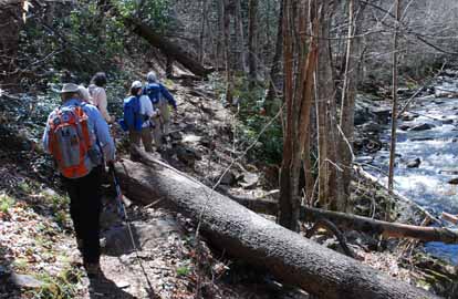 
Photos by Elaine Pearsons
Nine hikers enjoyed the beauty of the East Fork of the Pigeon River, led by Barbara Morgan. Recent rains raised the level of the river to give spectacular beauty to the waterfalls, cascades, and pools we could see for most of the hike. The weather was perfect - sunny and pleasantly warm.
This hike is an in and out of about 8.5 miles, with a gradual ascent of about 1200 feet. The trail was in good shape with the exception of some downed trees near the border between Shining Rock Wilderness Area and Pisgah Forest. We began the hike about 11:15 and finished about 4:30, taking about 5 hours to do the hike, including stops. Most of the hike runs alongside the East Fork of the Pigeon River, with a few detours around difficult areas.--Barbara Morgan
SUNDAY NO. A1002-201 Apr. 11
MST: NC 80 over Woods Mtn. to Woodland Park *8:00 AM
Hike 12, Drive 85, 2600 ft. ascent, Rated A-AA
Don Gardner, 828-754-4067, gardog3@bellsouth.net
*Form carpools at Westgate, and meet leader at Little Siena Restaurant at intersection of US 70 and NC 80 at 8:30 AM. We will hike a little-traveled and scenic section of the MST over Woods Mtn. and on to US 221,with seldom-seen views of the Blacks and Mt. Mitchell. Long descent. Car shuttle. Topos: Celo, Little Switzerland
What an excellent day for a hike! Cool to start and warming quickly. Not a cloud in the sky and panoramic views which would be hard to match on any hike. We had 13 hikers which started hiking at 9:30 am where NC80 joins the BRP. This hike had a number of blow downs and obstacles from a tough winter. The wind and ice took its toll on many trees with their tops snapped off. But the trail was a lot better than when scouted in late February.
The first half of this hike is like a roll coaster with a tough uphill toward the midpoint. Then it is all downhill the second half of the hike. At about the half way mark we took the side trail east to the site of the former Woods Mountain Lookout Tower. The only remnants are the 4 concrete base corners and an old metal commode. The tower site was our lunch spot. (I am going to talk to the Challenge committee about adding this as a possible site for Lookout Tower challenge.)
There were very few wildflowers as it was dry and not much rain had impacted this area for awhile.
Much fun was had by all as we meandered on the trail, traded stories and learned much from each others' experiences. You could not ask for greater camaraderie or a nicer hike.--Don Gardner
Don Gardner
Half Day Sunday
HALF-DAY NO. H1002-685 Apr. 4
North Slope Loop Trail *12:30 PM
Hike 4.5, Drive 65, Rated C-C
Nonmembers, call leader, Lucy Prim, 828-693-6580, 32lucette@gmail.com
P400 *Form carpools at Westgate, and meet hike leader at Pisgah Ranger Station, US 276 at 1:15 PM. A short pleasant hike starts at the Pisgah Ranger Station, goes up the North Slope Ridge, and back along the Davidson River.
Thirteen hikers did the North Slope Loop today. What a splendidly warm and sunny day it was for hiking! One of our group is studying plant taxonomy at Mars Hill, so we had great fun looking for and naming all the interesting plants we could find along the trail. The Davidson River was rushing along briskly making quite a nice loud splashing to listen to as we walked along that section of the trail. It was a very nice hike with great conversations and new people to meet. I think we all had a lovely time.--Lucy Prim
HALF-DAY NO. H1002-675 Apr. 11
Jones Gap S.P. – Rainbow Falls *12:30 PM
Hike 4.6, Drive 120, 1200 ft ascent, Rated C-B
Nonmembers, call leader, Sawako Jager, 828-687-2547, baiko70@aol.com
P400 *Form carpools at Westgate, and meet leader at Cracker Barrel, I-26 exit 53 at 1:00 PM. We will follow the Jones Gap trail along the Middle Saluda River then follow the Rainbow Falls Trail uphill to beautiful Rainbow Falls. Return the same way.
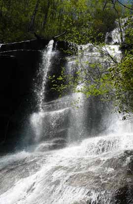 
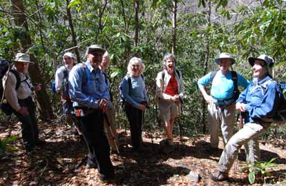
Photos by Sawako Jager
On a sunny 75-degree day, twelve hikers pleasantly agreed to do an alternate hike to the Falls Creek Falls instead of the Rainbow Falls due to no parking space left at the trailhead. The alternate hike involved some steep climbing up an old logging road through a boulder-chocked ravine. There was one rock hop stream crossing. After this strenuous one hour uphill workout, we were rewarded with two major views of a 100-foot waterfall. We stayed for over 45 minutes enjoying the magnificent waterfall and the cool mist, while lunching. While on the trail we identified over 15 different wildflowers. This was an excellent short hike which everyone agreed was fantastic.--Sawako Jager
--Back to Top
WEDNESDAY NO. W1001-398 Mar. 31
Sunburst- Green Knob - Haywood Gap Trails *8:30 AM
Hike 7, Drive 95, 2000 ft. ascent, Rated B-AA
Charlie Ferguson, 828-625-2677, ccf108@gmail.com
P400 This very strenuous and difficult hike will start with an initial very steep mile (up to 39 degree incline) to Green Knob and its spectacular views, then we’ll do a short bushwhack down to the Grassy Ridge Branch trail. We’ll return on the seldom-hiked lower Haywood Gap Trail returning to the Sunburst Campground. There are two wet crossings. *Wilderness area limited to ten people. Call leader for reservation. Second meeting place: Trailhead at Sunburst at 9:30 AM, but call leader first. Topo: Sam Knob; also NatGeo map #780
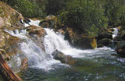
Photo by Charlie Ferguson
Twenty people wanted to do this very difficult hike on a Wednesday. Carroll Koepplinger volunteered to lead a separate group so that everyone could be accommodated on this wilderness hike. This is a report for the first group. Our group of ten were all regular CMC hikers. We started up the Fork Ridge on the Green Mountain Trail about 9:45 and started the initial steep climb, of a thousand feet in six tenths of a mile, that felt like 2000 feet. The entire trail up to Green Knob was very steep which would ordinarily invite trail erosion turning the trail into a rock filled rut. This trail is rarely hiked - sensible people stay away. Since 30 CMC hikers in the past week have wanted to hike it, we wonder where we fit into the sensibility disorder spectrum. After that hard climb we had 2000 feet left to the top in about 3 miles.
Steepness aside, it is a very nice trail with periodic views off to the left of the Shining Rock Wilderness. We had lunch in the open meadow at the top with some pesky king size gnats. We took our time on the Bushwhack down to the old rail bed and then a left for 400 feet to the CMC maintained Buckeye Gap trail. The Buckeye Gap trail was quite steep all the way down to the Middle Prong River, taxing our already tired legs. Wading across the cold, ten inch deep, river was either refreshing or painful, depending on whose legs were in the river. The rest of the hike was an easy walk on a well maintained forest service road. Nine miles and 3200 feet of climbing in 6 hours and 45 minutes.--Charlie Ferguson
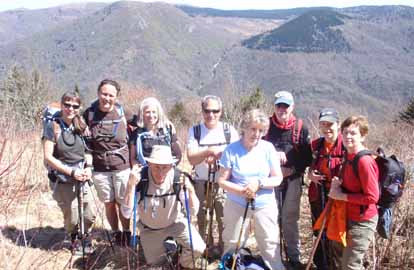
Photo by Carroll Koepplinger
I had the opportunity to lead a second group of ten hikers for the Green
Knob hike on 3/31/10. This group left the trail head at 10:00am, 15 minutes
after the first group. I might note here that there were a total of 30
hikers for this hike which also went Sat. 3/27. I'm impressed with that
many excellent hikers for such a strenuous climb.
It took our group about 4 hours to reach the peak at Green Knob. With such
beautiful weather and fantastic views along with the climb it was hard to
leave to continue on. After a somewhat difficult bushwack we reached the
Buckeye Trail and on to the Old Haywood Gap trail.
After reaching the Middle Prong for the first wet crossing we realized that
one hiker was missing. The hiker was experienced and prior to coming down
to the river and not seeing the person in front of her (nor did the sweep
see her) got off the trail. Here's the scenario: *hiker missing *hike
leader's heart drops into stomach *sweep goes back to look for her *missing
hiker shows up about 10 minutes later *missing hiker goes back to trail to
try to find sweep looking for her *can't find sweep *sweep returns about 20
minutes later **ALL'S WELL THAT ENDS WELL! This was my first experience re:
a lost/missing hiker - it was not the most pleasant feeling. Another
example why there should be visible contact along an entire hike.
Thanks to each indivual on this hike and special thanks to the sweep, Alan
who put in an extra mile or two. It was a great group!--Carroll Koepplinger
WEDNESDAY NO. W1002-652 April 7
Devil Fork Gap to Rocky Fork Rd. *9:00 AM
Hike 7, Drive 80, 1300 ft. ascent, Rated B-B
Don Walton, 828-654-9904, donwalton@bellsouth.net
*Be prepared for possible wet stream crossings. This hike ventures into the new Rocky Fork Tract purchase of 10,000 acres near Flag Pond, TN. The first three miles of this hike is on the AT to Flint Gap Shelter and on to Flint Gap and the entry into the Rocky Fork Tract. This route is also the path of a surprise attack on an Indian Camp in the early 1800’s. Car shuttle. Topo: Flag Pond
Seven hikers enjoyed the absolutely beautiful day hiking into the recently acquired 10,000 acre Rocky Fork Tract. The A.T. from Devil Fork Gap to Flint Gap is in near perfect condition but the 3 mile part of Rocky Fork has a lot of downed trees and limbs. A good day in the woods!--Don Walton
WEDNESDAY NO. W1002-694 Apr. 14
Mackey Creek Trail *8:00 AM
Hike 8, Drive 75, 1000 ft. ascent, Rated B-B
Joanne Tulip, 828-299-3495, tulipinnc@aol.com and Tommie Boston, 828-686-5029, tambee2@aol.com
*Form carpools at Westgate, and meet leaders at Ingles parking lot off Exit 64 of I-40 at 8:20 AM. From the Curtis Creek Road we descend steeply to Mackey Creek on a rough non-maintained trail. Hiking poles are recommended. Water shoes are also recommended for the several creek crossings. From the creek we ascend steeply on the Connector Trail to Lead Mine Gap. A two mile descent on the Hickory Branch Trail takes us to our cars at Curtis Creek campground. Short car shuttle. Topo: Old Fort
Email your hike reports to Dave Wetmore. The deadline for reports is 9:00 p.m. on the Tuesdays before an eNews comes out. Reports for Wednesday hikes during the eNews publication week will appear in the following eNews--The Editor.
--Back to Top
All-day hikes submitted by Bruce Bente 692-0116, bbente@bellsouth.net . Driving distance is round-trip from Asheville. All Saturday and Sunday hikes assemble at Westgate Shopping Center near I-240 UNLESS OTHERWISE NOTED.
Half Day hikes submitted by Lucy Prim 828-693-6580 lucette32@mchsi.com.
Wednesday Hikes are submitted by Charlie Ferguson, 828-398-0213 ccf108@gmail.com and Ann Gleason, 828-859-9387,
gleason.ann@gmail.com .
The meeting place for each hike will be designated by the hike leader and appears in the hike description.
Driving mileage is round trip, based on the first designated meeting place. Meet at Westgate unless otherwise noted.
|
