All Day Saturday & Sunday
SUNDAY NO. A102-6093 June 6 - National Trails Day hike
Tusquitee Bald (Bernard Elias Favorite Hike series #2) *8:00 AM
(strenuous)
Hike 8, Drive 210, 2100 ft. ascent, Rated B-AA
Ted Snyder, 864-638-3686, tedsnyderjr@bellsouth.net
*Form carpools at Westgate, stop at rest area beyond Waynesville on US 23/74 at 8:30 AM, and meet leader at jct. of US 19/74 and SR 1310 (Nantahala River Put-in) at 10:00 AM. Up Big Tuni Creek on the Chunky Gal Trail to Tusquitee Bald where we join the Fires Creek Rim Trail and follow a ridge to County Corners, and then down Old Road Gap Trail. Glorious views from Tusquitee Bald. Short car shuttle. Topo: Topton; also NatGeo map #784
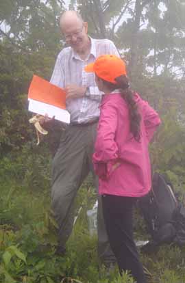 
Photos by Jim Reel
Bernard's route started at Old Road Gap, to which he was able to drive. Since then the road through the gap has been blocked on both sides. So we made a substitution, climbing to Tusquitee Bald on the tail end of the Chunky Gal Trail. From the Bald back down to Old Road Gap we followed Bernard's incoming route. That left us a two mile walk on a Forest Service system road to the gate where we had left a shuttle car.
Twelve hikers set out in light rain. By noon the rain had stopped, but we had entered the clouds. We reached Tusquitee at the advertised lunch time and ate there. Then John Ray, author of the Chunky Gal Trail and Fires Creek Rim Trail guide took over. He led us on a side excursion to a much larger, but little known and rarely visited bald. Critically, he showed us where the springs were.--Ted Snyder
For a more complete report, click here.
SUNDAY NO. A1002-516 June 6 - National Trails Day hike
Lakeshore Loop 8:30 AM
(moderate)
Hike 8, Drive 145, 800 ft. ascent, Rated B-C
Danny Bernstein, 828-236-0192, danny@hikertohiker.org
900M Starting at the Lakeshore tunnel, we’ll do an easy loop, consisting of the Lakeshore, White Oak Branch and Forney Creek Trails. We’ll lunch at the Fontana Lake shoreline, and then return on the Lakeshore trail and back on the bypass trail. We’ll see house sites, a creek and cemeteries and the historic “Road to Nowhere”. Second meeting place: Rest area beyond Waynesville on US 23/74 at 9:00 AM. Topo: Noland Creek; also Nat Geo map #229
 
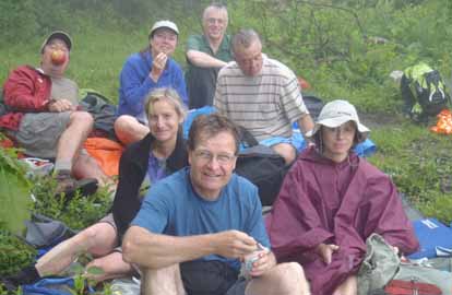
Photos by Danny Bernstein and Sawako Jaeger
With a splint on my right hand, I led eight other eager Carolina Mountain Club hikers on a loop from the "Road to Nowhere" tunnel in the Great Smoky Mountains National Park. This area, though beautiful and green, shines because of its history. Click here for National Park Traveler piece on the background on the Road to Nowhere. Most of the folks that came on the hike were there to see the "Road to Nowhere" for themselves.
First we stopped at the signboard funded by locals which shows the bitterness that still persists. I don't know how long this board will be up.
We entered the park and drove another six miles to the tunnel. On a combination of trails, we met backpackers going or coming back from campsite #74 on Forney Creek. The highlight for me was the visit to Woody Cemetery off Lake Shore Trail - it was a good climb. We talked about what goes on at Decoration Days. Anyone can go and you'll be treated with the utmost respect.
Toward the end of the hike, we took the Tunnel By-pass trail. The sign had been turned 90 deg. the wrong way and was confusing to the group. We tried to pull it out of the ground and turn it but we couldn't. I plan to let the Smokies maintenance people know about it.--Danny Bernstein
SATURDAY NO. A1002-570 June 12
Dupont Forest – Corn Mill Shoals P.L. #2 *10:00 AM
Hike 7, Drive 80, 300 ft. ascent, Rated B-C
Kathleen Hudson, 828-698-5208, mstish1325@gmail.com
*Form carpools at Westgate, and meet hike leader at Hooker Falls parking lot in DuPont Forest at 10:45 AM. Several trails will take us to the top of the rushing waters of Bridal Veil Falls for lunch, and a close up view and walk behind the falls. Start at Corn Mill Shoals Road parking lot and we'll be on Burnt Mountain Trail, Little River Trail and Bridal Veil Falls Trail. Topo: Standingstone Mtn.; also DuPont Forest trail map.
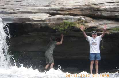 
Photos by Kathleen Hudson
The hike was great but not at all as described. The original planned hike would have taken us onto private Dupont property, or closed trails, or a very slippery wet river crossing. Therefore, we did a short car shuttle and hiked from the Fawn Lake parking lot to the Hooker Falls parking lot viewing Bridal Veil, High and Triple Falls.--Kathleen Hudson
SUNDAY NO. A1002-674 June 13
Wayah Bald – Wesser Bald 7:30 AM
Hike 12.6, Drive 175, 2087 ft. NB ascent, 3450 ft. SB ascent, Rated AA-AA
Jacob Cox, 828-584-0395, jcox@mfgnc.com and Carroll Koepplinger, 828-667-0723, carrollkoepp@bellsouth.net
LTC Note early start time. This great AT hike will visit two lookout towers, each with 360 degree views of the mountains. Strenuous hike. Key-swap hike. Optional supper at Jarrett House after the hike. Second meeting place: Rest area beyond Waynesville on US 23/74 at 8:00 AM, but call a leader first. Topos: Wayah Bald, Wesser; also NatGeo map #785
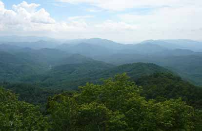
Photo by Sawako Jaeger
I led the northbound section of this hike with five hikers. After a couple of “oops” (missing the turnoff to Wayah Bald) we were ready to go at 10:30 am. After looking at the damage done to the tower by idiots (they really knocked out a large portion of the north wall). we proceeded down the trail under pleasant weather. Some clouds and mist with no rain during the entire hike.
We met the south bound group of nine hikers near the halfway mark. After exchanging car keys we proceeded to the shelter for lunch. There were about 12 to 15 other hikers at the shelter so we moved to the side a few yards away and enjoyed a pleasant and relaxing lunch. We reached the cars with some of us leaving packs and taking only rain gear and water to proceed on the A.T. to Wesser Bald Tower. Even with some haze in the distance we had fantastic long range views. Clingmans Dome was visible with some haze covering the top. We returned down the old Jeep road and returned to the cars at 5:05 pm. All fourteen of the hikers enjoyed friendship and fine food at the Jarrett House in Dillsboro.--Carroll Koepplinger
--Back to Top
Half Day Sunday
HALF-DAY NO. H1002-573 June 6 - National Trails Day hike
Devil’s Courthouse from FS 816 *12:00 PM
Hike 5, Drive 75, Rated C-C
Nonmembers, call leader, Becky Elston, 828-749-1886, cell phone 828-606-0583, belston@tds.net
P400 *Form carpools at Westgate, and meet leader at Cold Mountain Overlook (BRP M.P. 412) at 12:40 PM. The hike will differ slightly from #573 but will be nice and cool at 5000 feet and afford great views from Devil’s Courthouse. Topo: Sams Knob.
The weather was a little iffy but 12 of us started out in a slight drizzle which lasted about 2 minutes. Then the day turned partly sunny/cloudy and it was a perfect day with great views from Devils Courthouse. The hike is probably closer to 6 miles than the 5 stated in the "Let's Go", but no one minded. Had an 11 year old grandson of one of the members, and he was a great hiker.--Becky Elston
HALF-DAY NO. H1002-294 June 13
Picklesimer Fields 1:00 PM
Hike 5, Drive 65, Rated C-B
Tom Sanders 828-252-6327, tomary.avl@gmail.com
In and out hike from the Fish Hatchery. We'll take Butter Gap Trail and see how far we get. Second Meeting: Place Fish Hatchery at 1:45 PM.
The weather forecast was for 90 degrees, but 10 brave people showed up for this hike, including 3 who were new to CMC. Actually it didn't seem quite that hot. We began at the Fish Hatchery in Pisgah Forest and followed the Butter Gap Trail for an hour and a half, before snacking in a clearing beside a stream and then returning. This is a beautiful trail and perfect for a half-day Sunday. It's also moderate with no long or steep uphill, so almost anyone can do it. It features three waterfalls, which were exceptional because of this year's rains, beaver dams, and beautiful pine groves. And of course afterwards we enjoyed ice cream at Dolly's.--Tom Sanders
--Back to Top
WEDNESDAY NO. W1002-104 June 2
Wolfe Ford and High Falls *9:00 AM
Hike 7.3, Drive 80, 900 ft. ascent, Rated B-C
Laura Frisbie, 828-337-5845, laurafrisbie@charter.net
P400 *Form carpools at Westgate, and meet leader at Bi-Lo in Pisgah Forest at 9:30 AM. From the gauging station on the South Mills River, we'll hike this mostly level trail to High Falls, then cross the footbridge at Wolfe Ford and loop back to the trailhead. One possibly wet stream crossing. Topo: Pisgah Forest; also NatGeo map #780
Eight people showed up for a forecast of 50% chance of rain. We left with clear skies and high hopes, planning an in and out hike to the falls rather than the Wolfe Ford loop. (Scouting the hike a week prior had revealed that the Wolfe Ford via the Rigby Cutoff had become too overgrown.) We hiked 3.75 miles to High Falls using the ridge trail. Our 87 year old hiker mentioned that he didn't relish facing the steep 300' ascent upon return, so we took a longer but level route back, making for a lovely loop hike after all.
We succeeded in keeping our feet dry on the stream crossing (thanks to Charlie and Jeannie making a rock bridge during the scout trip) only to have it start raining sixty seconds later. It rained cats and dogs the entire return route, turning the trail into a continuous 5 mile stream. Kayco reported that the hike was nearly 9 miles and she was happy to find Asheville nearly dry, so she could play tennis after her hike. ("Different muscles", she says.) --Laura Frisbie
WEDNESDAY NO. W1002-008 June 9
Bee Tree Gap to Tanbark Tunnel *9:00 AM
Hike 6.2, Drive 30, 1300 ft. ascent, Rated B-B
Joe Burchfield, 828-298-8413, Burchfield@niu.edu.
*Note that the only meeting place is the back parking lot of the Folk Art Center. A moderate hike on the MST over Lane Pinnacle. Good mountain views and, with luck, the rhododendrons will be in bloom. There are several steep but short ups and downs and a long descent. Topo: Craggy Pinnacle; also new MST Profiles, Pg. 58-59
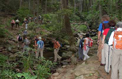
Photo by Ted Connors
Road work on the BRP made it impossible to park near the trail head for the scheduled hike. Therefore the 30 hikers who gathered at the Folk Art Center found Plan B in operation -- a hike along trails on the east side of Montreat. After a bit of confusion, we regrouped in the already over full Anderson parking lot in Montreat (herding cats was mentioned several times). We jammed into few enough cars to park us all at the Greybeard trail head. We then climbed the Greybeard Trail to Pot Cove Gap, recouped with a gentle stroll along the Trestle Road Trail to Long Gap, then resumed climbing on the East Ridge Trail over Rocky Head to our lunch spot at Sourwood Gap. After lunch we had another gentle, ?digestive? stroll along the Old Toll Road before beginning our final climb over Boggs Bunion to Lookout Rock to enjoy the fine view of the Blacks, Craggies, and Middle Mountains. We then descended by the Lookout Trail. The drivers shuttled off to fetch the cars while the rest of us walked down to meet them at Montreat College Chapel. It was a good day, the predicted rain held off, the temperature was mild, and an understanding group of hikers raised no complaints about a hastily organized Plan B. Finally, I'd like to express my appreciation to the folks at Montreat who generously make their trails available to us.--Joe Burchfield
WEDNESDAY NO. W1002-566 June 16
The Roans *8:30 AM
Hike 8 Drive 130, 1000 ft. ascent, Rated B-B
Adrian Lotherington, 828-484-9132, jaloth@charter.net
SB6K *ONLY MEETING PLACE: Rose’s car park (opposite McDonalds), exit 19B off I-26 in Weaverville. This in-and-out hike features great views. From Carver’s Gap we go over Jane Bald and Round Bald to Grassy Ridge Bald. With luck we will hit the rhododendron bloom. If time allows we will drive to the gardens and walk ½ mile to see the view from Roan High Bluff (small fee).
Email your hike reports to Dave Wetmore. The deadline for reports is 9:00 p.m. on the Tuesdays before an eNews comes out. Reports for Wednesday hikes during the eNews publication week will appear in the following eNews--The Editor.
--Back to Top
All-day hikes submitted by Bruce Bente 692-0116, bbente@bellsouth.net . Driving distance is round-trip from Asheville. All Saturday and Sunday hikes assemble at Westgate Shopping Center near I-240 UNLESS OTHERWISE NOTED.
Half Day hikes submitted by Lucy Prim 828-693-6580 lucette32@mchsi.com.
Wednesday Hikes are submitted by Charlie Ferguson, 828-398-0213 ccf108@gmail.com and Ann Gleason, 828-859-9387,
gleason.ann@gmail.com .
The meeting place for each hike will be designated by the hike leader and appears in the hike description.
Driving mileage is round trip, based on the first designated meeting place. Meet at Westgate unless otherwise noted.
|
