|
Looking Ahead
All Day Saturday & Sunday
ALL DAY NO. A0704-580 Oct. 14
Maintenance Theme Hike 8:30 AM*
Hike 7.5, Drive 25, moderate ascent, Rated B-B
Barth Brooker, 828-299-0298, barthb@bellsouth.net
*Note later start time. Ever wonder how CMC maintains the trails that we hike on? This moderate hike will travel a typical trail and will point out what and how to maintain it. The hike will be from the new Blue Ridge Parkway Headquarters to Craven Gap. We will discuss the maintenance tools that are used to maintain trails and point out type of problems we encounter. We want a two way exchange of ideas to help maintenance determine what issues are most important to the hikers and we will discuss the things done on the trail to correct and prevent future problems. The hikers will be challenged to spot potential problems and to explain why certain things have been done to the trail in the way of maintenance. Since trail maintenance is more of an art than a science, we can expect some lively discussions. Second meeting place: Craven Gap at 8:50 AM.
ALL DAY NO. A0704-581 Oct. 21
Balsam Mtn. – Pretty Hollow – Palmer Creek Loop 8:00 AM
Hike 15.6, Drive 110, 2700 ft. ascent, Rated AA+-AA+
Don Gardner, 828-754-4067, gardog3@bellsouth.net
900M This new CMC hike will cover some rarely-hiked and scenic trails. It will start at Pin Oak Gap and follow the Balsam Mtn., Mt. Sterling Ridge, Pretty Hollow and Palmer Creek trails. Second meeting place: Maggie Valley Post office at 8:30 AM. Topo: Luftee Knob; also Nat’l. Geo. GSMNP map #229 Half Day Sunday
HALF-DAY NO. H0704-578 Oct. 14
Flat Laurel Creek, Little Sam Knob, MST Loop 12:30 PM*
Hike 6.5, Drive 80, Rated B-B
Nonmembers, call leader, Marcia Bromberg, 828-505-0471, mwbromberg@yahoo.com
P400 *Note early start time. This is a pleasant loop trail with views of Big Sam Knob, Fork Ridge and the lovely Flat Laurel Creek. We'll begin on the Flat Laurel Creek Trail, which ascends gradually until we are hiking next to the creek, where we will stop for a snack. Little Sam Knob Trail, with views of Little Sam Knob and Sam Knob, connects to the Mountains-to-Sea Trail, which will take us back down to our starting point at NC 215. Second meeting place: Pisgah Inn, north end of parking lot at 1:00 PM.
HALF-DAY No. H0704-553 Oct. 21
Montreat Loop #4 1:00 PM
Hike 5, Drive 40, Ascend 1000-ft., Rated C-B
Nonmembers, call leader, Joe Burchfield, 828-298-8413, burchfield@niu.edu
This is a moderate hike ascending the Lookout Trail over Lookout Rock and then following the East Ridge Trail to Sourwood Gap. Return will be by the Toll Road, the Buck Gap Trail, and the Old Trestle Road to the Lookout Trail. After a moderately steep ascent and a short rock scramble, we will follow the ridge trail over several knobs and then return with an easy walk along the Toll and Trestle Roads. Second meeting place: Parking lot adjacent to McDonald's in Black Mountain off Exit 64 of I-40 at 1:25 PM. All Day Wednesday
WEDNESDAY NO. W0704-584 Oct. 10
Butter Gap Loop 8:00 AM*
Hike 9, Drive 75, 2000 ft. ascent, Rated A-AA
Tom Bindrim, 828-273-3880
P400 One of Tom's favorites for near 30 years, we'll use parts of the Cat Gap Loop, ALT,
and all of the Butter Gap trail through the beautiful Grogan Creek watershed to Picklesheimer Fields. Moderately paced, lots of stops, long lunch, expect late return. *Meet at Westgate at 8:00 AM to form carpools, and meet leader at Pisgah Fish Hatchery at 8:45 AM. Topos: Shining Rock, Rosman; also Nat’l. Geo. PRD map #780
WEDNESDAY NO. W0704-560 Oct. 17
Rube Rock/Groundhog Creek Loop 8:00 AM
Hike 9, Drive 100, 1900 ft. ascent, Rated A-A
Danny Bernstein, 828-236-0192, danny@hikertohiker.com
A beautiful loop hike, rich in fall foliage, located in the Harmon Den area of Pisgah Nat'l. Forest. We'll start at Brown Gap, then hike the A.T. to Rube Rock Trail which descends into the Pigeon River Gorge. Then we'll climb the Groundhog Creek Trail, to the A.T. and back to Brown Gap. Second meeting place: Pilot Truck Stop off I-40 at Exit 24 at 8:30AM. Topo: Waterville, also Harmon Den & Hot Springs Area Trail Map, USFS map.
WEDNESDAY NO. W0704-204 Oct. 24
Max Patch Ramble 8:00 AM
Hike 7.5, Drive 100, 1100 ft. ascent, Rated B-B
Adrian Lotherington, 828-484-9132, jaloth@charter.net
A late fall hike that may be our last opportunity to scale this beautiful section of the AT before Jack Frost descends! We will begin and end at Max Patch, one of WNC's most stunning views. Second meeting place: Pilot Truck Stop at Exit 24 off I-40 at 8:30 AM. Topo: Lemon Gap. Looking Back......
All Day Saturday & Sunday
SATURDAY NO. A0703-095 Sept. 29
Hemphill Bald from Polls Gap 8:30 AM*
Hike 9.5, Drive 95, 1900 ft. ascent, Rated A-A
Danny Bernstein, 828-236-0192, danny@hikertohiker.com
900M *Note later start time. After a stroll through open forests, the trail emerges into open fields stretching along the GSMNP boundary, with exceptional views all the way to our lunch stop at the big rock on Hemphill Bald. This hike is the CMC contribution to the WNC “Together We Read” program, which this year is reading “On Agate Hill”, by Lee Smith. Second meeting place: Maggie Valley Post Office, rear of parking lot, at 9:00 AM, but contact leader first. Topos: Dellwood, Bunches Bald; also Nat’l. Geo. GSMNP map
 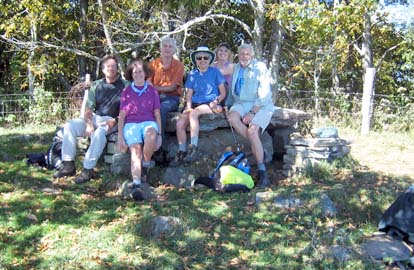
What an incredible day to an outstanding place. The trail starts at Poll's Gap past the Blue Ridge Parkway extension, itself a driving adventure. It climbs gently up and down the edge of the Great Smoky Mountains National Park to Hemphill Bald. Hemphill Bald is private but owned by Cataloochee Ranch. The owners have put several hundred acres of their land in a conservation easement. That means that an heir of the current owners cannot sell that land for development. The views toward Cold Mountain and Mt. Pisgah and down to Maggie Valley were fabulous. We had two new hikers, who learned about the benefits of our club. Danny. Photo on left by Danny, on right by Charlie Ferguson.
ALL DAY NO A0703-385 Sept. 30
Upper Little East Fork - Fork Mt. Slow Loop phone leaders for time
Hike 11-12, Drive 100, 2100 ft. ascent, Rated A-AA
Tom Bindrim & Joan Lemire, 828-273-3880, tjbindire@yahoo.com
A moderately-paced Wilderness Area loop with upper elevation scenery, water and a workout. Expect a late return, bring extra food. This is a wilderness area limited to ten people. Call leaders for reservations and meeting particulars. Topos: Sam Knob, Shining Rock
No Report
ALL DAY NO. A0704-548 Oct. 7
AT: Sams Gap to Big Bald 8:00 AM (strenuous)
Hike 13, Drive 55, 2600 ft. ascent, Rated AA-AA
Lenny Bernstein, 828-236-0192, lsberns@worldnet.att.net
This will be a challenging AT hike up to see spectacular views from the summit of Big Bald. If the weather is clear, we will be able to see into the Rocky Ford Tract that ATC is trying to buy to protect the AT viewshed. Topo: Sams Gap
It was a great hike, and even though it was AA-AA, there were few steep places, and it did not seem as strenuous as the rating would indicate.
Nine CMC'ers were joined by Liz Maloff, a section hiker from Maine who is doing tow weeks of AT hiking in our area. She hiked with us as far as Big Bald, then continued on to Spivey Gap.
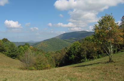
The hike has two open areas, a meadow at two miles, a little before Street Gap, then the top of Big Bald. We took breaks at the meadow, coming and going, and a long lunch break on top of Big Bald. From the top of Big Bald we got a 360 degree view. To the east we could see Mt. Mitchell and the route of the Death March. To the west we could see the Rocky Fork Tract that ATC is trying to buy to protect part of CMC's section of the AT. Closer in there were signs of civilization: Wolf Laurel and some farms and houses, but they were merely pinpricks on an otherwise green vista. Lenny. Photos by Jim Reel.
ALL DAY NO. A0704-365 Oct. 7
Mt. Mitchell Ramble 9:00 AM*
(Moderate)
Hike 8, Drive 75, 1400 ft. ascent, Rated B-B
Tom Sanders, 828-252-6327, tomary2@charter.net
SB6K *Note later start time. We’ll do a loop on several trails in the Mt. Mitchell area, including the Old Mt. Mitchell Trail, Camp Alice Road and the Commissary Ridge Trail. An optional side trip to Mt. Craig (6647 ft.) and Big Tom will be offered afterwards, where we can hike see the amazing rockwork being installed on the newly rebuilt trail. Second meeting place: Craven Gap on BRP at 9:15 AM Topos: Mt. Mitchell, Montreat; also PNF South Toe River, Mt. Mitchell & Big Ivy Trail Maps
On a fabulous day, warm, sunny, clear, 9 people explored the Mt. Mitchell region
which is altered by construction of the new overlook.
We began at the parking lot, took a detour to the Old Mt. Mitchell Trail,
down to Stepp Gap, enjoying the views on the way. We then went along the Camp Alice gravel road to our lunchspot
at the stream that crosses the road. At all times views were exceptional, and we were awesomely impressed that fall leaves had turned so early in the 6000 plus elevations where we were hiking. Since we had dawdled along, the Commissary Ridge Trail perked us up with a rigorous climb back up to the parking lot. Access to Mt. Mitchell is prohibited because of the construction. To top it off we went out to Mt. Craig, admiring the excellent trail improvement on the first half. All the way: great weather, views, and fall foliage. Tom
Half Day Sunday
Saturday September 29 Sycamore Cove Trails 1:00 PM
Hike 6, Drive 4, 1200-ft elevation, Rated B-B
Leader: Stuart English, 828-883-2447 stuengo@citcom.net
P400 A moderate hike in the Pisgah National Forest along several trails, including Thrift Cove and Grassy Road.
Participants should bring an adequate amount of water, snacks in a pack, proper footwear, (no flip flops), and be prepared for a gradual 1200 foot ascent. Example: The climb to Mt. Pisgah from the parking lot is 700 feet. We will meet at the parking lot of Poppies Market and carpool to the Davidson River Campground parking lot. This is a special hike for the Brevard Outdoor Festival.
It was a beautiful, cool, cloudless day at the Poppie’s Market for the Brevard Outdoor Festival. CMC had a booth with our poster and newsletters. Lenny Bernstein, Ashok Kudva, Jean Gard, Stuart English, Lucy Prim and Rusty Breeding were there to give a good representation of our club. Many interested people stopped by and picked up a newsletter. In the afternoon seven people participated in the hike of Sycamore and Thrift Coves near Davidson River campground. Four of them were CMC members and three were prospective CMC members. Stuart
HALF-DAY No. H0703-318 Sept. 30
Big Ridge Overlook to Beaver Dam Overlook 1:30 PM
Hike 4.4, Drive 35, Rated C-C
Nonmembers, call leader, Paula Robbins, 828-281-3253, paularww@bellsouth.net
This in-and-out hike along the Mountains-to-Sea Trail near milepost 403 of the Blue Ridge Parkway is a good one for beginners. It will feature some fall wildflowers and good views. Second meeting place French Broad Overlook of the Blue Ridge Parkway off NC 191 at 1:45 PM.
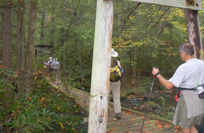
Twenty-four CMC hikers, including several newcomers, started out on a perfect early fall day for a hike of 4.6 miles on the Mountains-to-Sea Trail. An earlier scouting trip had discovered several yellow jacket nests in the middle of the trail just south of the Beaver Dam Gap parking area, so the hike was changed to go from Stony Bald Overlook to the Mills River Overlook and return. Many fall wildflowers were identified, including several varieties of asters, goldenrod and gentian. The area along the trail just south of the point where the trail crosses the Blue Ridge Parkway between the Stony Bald Overlook and the Big Ridge Overlook was especially rich with ferns, including Maidenhair, Cinnamon, Christmas, and polypodium. All arrived safely unbitten at around 5 PM at the parking area. Paula Robbins.
HALF-DAY No. H0704-035 Oct. 7
Looking Glass Rock 1:00 PM*
Hike 6, Drive 70, Rated B-B, 1,800 ft. ascent
Nonmembers, call leader, Rusty Breeding, 828-692-0359, bree_lw@planetusa.net
P400 A moderately difficult well-graded trail leads to the top of this mountain with beautiful views along the way. In-and-out hike. *Meet at Westgate at 1:00 PM (note early start time) to form carpools, and meet hike leader at the Pisgah Ranger Station on at 1:30 PM.
Eighteen went up.
Eighteen came down.
A warm autumn day.
(Well, HOT on the up-climb).
An occasional cool breeze.
Pace: leisurely. (OK. Slow).
Animals sighted:
One 5-foot black snake climbing a laurel
at eye-level, within arm's length of the trail.
Two garter snakes scurried off – only the leader observed.
Other species: Innumerable two-footed creatures descending.
The hike terminated at the heli-pad overlook with a long break.
Very impressed by the view: Several visitors and newish members.
Hike started at 2:00 pm. Back to cars at 5:30 pm..
Rusty with help from Co-Leader: Jean Gard and Sweep: Joe Burchfield
Wednesday
WEDNESDAY NO W0703-120 Sep. 26
Charlies Bunion, Grassy Branch to Kephart Prong 8:00 AM
Hike 10-11, Drive 140, 1800 ft. ascent, Rated A-A
Danny Bernstein, 828-236-0192, danny@hikertohiker.com
900M An exciting adventure through the heart of the Smokies from Newfound Gap to Charlies Bunion on the A.T., then down the Dry Sluice Gap to Grassy Branch Trail, past the Kephart Shelter, and then paralleling a creek on Kephart Prong Trail to U.S. 441. This hike is even more exciting for those trying to log some of those hard-to-get Smokies 900 miles. Beautiful views, lovely stream and late summer flowers. Second Meeting Place: back of Maggie Valley Post Office parking lot at 8:35 AM, but phone leader beforehand. Topos: Clingman’s Dome, Mt. LeConte, Smokemont; also Nat’l. Geo. GSMNP map
 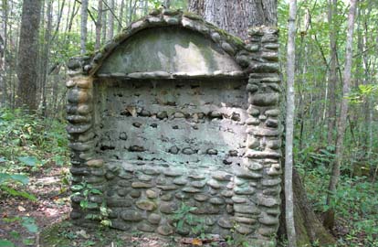
A walk to Charlies Bunion on the A.T. is always a great trip. But on this hike, we continued down Dry Sluice Gap and Grassy Branch Trails to Kephart Shelter, into the heart of the Smokies. The site of the present-day Kephart Shelter was a logging camp, owned by Champion Lumber Company. Kephart Prong Trail had obviously been a road and several artifacts are still left. We crossed Kephart Prong several times, each crossing on a better quality bridge. As we approached Newfound Gap Rd. where we had left a car, we passed the site of an old CCC camp with stone walls, chimney and other signs of civilization. See the photo above of the stone structure which once held a sign to the entrance. Danny. Photos by Danny Bernstein
WEDNESDAY NO W0704-408 Oct. 3
Wolf Ford Loop 8:00 AM*
Hike 9, Drive 80, 1200 ft. ascent, Rated B-B
Greg Goodman, 828-684-9703,
P400 Start at the gauging station and hike the South Mills River trail to Wolf Ford, Squirrel Gap, Horse Cove and to FS 5018, then along Funnel Top Ridge, left onto Soapstone Ridge and back to cars. *Meet at Westgate at 8:00 AM to form carpools, and meet leader at Pisgah Ranger Station at 8:30 AM. Topo: Shining Rock; also Nat’l. Geo. PRD map
Photos by Ted Connors
WEDNESDAY NO. W0704-585 Oct. 3
Chestnut Mtn., Searcy Creek Loop 8:00 AM*
Hike 6-7, Drive 75, 800 ft. ascent, Rated C-C
Larry Ballard, 828-891-4318, leballard@cytechcis.net
P400 On this new and moderate hike, we’ll hike up FS 5095 from FS 475 to near the summit of Chestnut Mtn., then do a short, steep but easy bushwhack in open woods down to the Butter Gap Trail. We’ll follow this trail north, then west onto the Long Branch Trail and return on FS 5095. Along the way we’ll stop at a great overlook. *Meet at Westgate at 8:00AM to form carpools, and meet leader at Pisgah Ranger Station at 8:35 AM. Topo: Shining Rock; also Nat’l. Geo. PRD map #780
All-day hikes submitted by Bruce Bente 692-0116, bbente@bellsouth.net . Driving distance is round-trip from Asheville. All Saturday and Sunday hikes assemble at Westgate Shopping Center near I-240 UNLESS OTHERWISE NOTED.
Half Day hikes submitted by Paula Robbins 828-687-1651 paularww@bellsouth.net.
Wednesday Hikes are submitted by Charlie Ferguson, 828-398-0213 ccf108@gmail.com and Ann Gleason, 828-859-9387,
gleason.ann@gmail.com .
The meeting place for each hike will be designated by the hike leader and will appear in the hike description.
Driving mileage will be listed, round trip, from the first designated meeting place.
Leaders: Mail please mail your sign-up sheets. Meet at Westgate unless otherwise noted. |
 CMC Bi-Weekly Hike News