|
Looking Ahead
All Day Saturday & Sunday
SATURDAY NO. A0802-454 April 26
Porters Creek Trail *9:00 AM
Hike 7.4, Drive 160, 1500 ft. ascent, Rated B-A
Ashok Kudva, 828-698-7119, ashok.kudva@mchsi.com
900M *Note later start time. This trail is famous for its wildflower displays. We will first pass the remnants of old homesteads and the Owenby cemetery before entering a moist sheltered cove with large trees, masses of wildflowers, a rushing creek and even a waterfall. Optional supper after the hike at Bear Creek Grille. Second meeting place: Pilot Truck Stop at exit 24 of I-40 at 9:30 AM, but call leader first. Topo: Mt. Le Conte; also Nat’l. Geo. GSMNP map #229
ALL DAY NO. A0802-066 Apr. 27
AT: Garenflo Gap – Bluff Mtn. *8:30 AM
Hike 8.5, Drive 80, 2200 ft. ascent, Rated B-AA
Jim Reel, 828-738-0751, jimr57@yahoo.com
*Note later start time. We’ll do an in-and-out hike on the AT in hardwood forests from Garenflo Gap to the summit of 4686 ft. Bluff Mtn. We will enjoy the many wildflowers that carpet the forest floor while the leader shows off the AT section that he maintains. After lunch on the summit it will be all downhill back to the trailhead. Topo: Lemon Gap
ALL DAY NO. A0802-605 May 4
Forney Ridge - Noland Creek & Divide *7:30 AM
(strenuous)
Hike 17, Drive 145, 3500 ft. ascent, Rated AA+-AA+
Don Gardner, 828-754-4067, gardog3@bellsouth.net
900M *Note early start time. Strenuous hike! This hike is designed for 900M fans and will cover a series of hard-to-get trails in the Clingman’s Dome area. We will hike down the Forney Ridge and Springhouse Gap Trails, then turn uphill on the Noland Creek and more steeply on the Noland Divide Trail back to Clingman’s Dome Rd. Short car shuttle. Second meeting place: Maggie Valley Post Office parking lot at 8:00 AM, but must call leader first. Topos: Clingman’s Dome, Silers Bald, Noland Creek, Bryson City; also Nat’l. Geo. GSMNP map #229
ALL DAY NO. A0802-060 May 4
Pilot Mtn. – Farlow Gap *8:30 AM
(moderate)
Hike 8, Drive 80, 1900 ft. ascent, Rated B-A
Ruth Hartzler, 828-251-0886, ruthmtn@charter.net
P400 *Note later start time. This hike is timed for what we hope will be the bloom of rare pink-shell azaleas and trout lilies. It starts with a steep climb to the summit of Pilot Mtn., then down to Deep Gap and a short climb over Sassafras Knob. It’s nearly all downhill or level as we continue to Farlow Gap with its trout lily flower display. We’ll return on a pleasant seldom-used graveled forest road. There will be several stops for photography along the way. Second meeting place: Pisgah Ranger Station at 9:05 AM. Topo: Shining Rock; also Nat’l. Geo. PRD map #780
Half Day Sunday
HALF-DAY NO. H0802-153 Apr. 27
Caney Bottom/Cove Creek *12:45 PM
Hike 5, Drive 75, Rated C-B
Nonmembers, call leader, Pat Elias, 828-687-1651, patelias@bellsouth.net
P400 *Note early start time. Meet at Westgate at 12:45 PM to form carpools, and meet hike leader at the Pisgah Ranger Station off US 276 at 1:30 PM. A pleasant walk through the woods, with streams, waterfalls, and bridge crossings.
HALF-DAY NO. H0802-049 May 4
Big Creek in the Smokies *12:30 PM
Hike 6, Drive 110, 1500 ft. ascent, Rated A-B
Nonmembers, call leader, Renate Rikkers, 828-298-9988, rerikkers@aol.com
900M *Note early start time. Big Creek, a spectacular mountain stream in the Smokies, offers hikers and walkers an opportunity to slow down and appreciate the wild beauty of this part of the park. The comfortable roadbed meanders along rushing rapids, a waterfall, huge boulders, and deep swimming holes. A beautiful forest and wildflower environment makes for a special experience. An easy in-and-out hike. Bring your camera! Second meeting place: Pilot Truck Stop, off I-40at Exit 24 at 1:00 PM, but call leader first. Topo: Luftee Knob, Cove Creek Gap; also Nat’l. Geo. GSMNP Map #229
All Day Wednesday
WEDNESDAY NO. W0802-607 April 30
Cat Gap Figure Eight Loop 8:00 AM
Hike 10, Drive 72, 2370 ft. ascent, Rated A-AA
Tom Bindrim & Joan Lemire, 828-273-3880
P400 *Meet at Westgate at 8:00AM to form carpools, and meet leaders at the Pisgah Fish Hatchery at 8:45 AM. This new CMC hike will be a combo of old favorites. Starting at the Pisgah Fish Hatchery, we'll do a figure-8 using the Cat Gap Loop, interrupted by a trip over Chestnut Knob and a trip around the John Rock Loop. All on trail, moderately paced, expect later return. Topo: Shining Rock; also Nat'l. Geo. PRD map #780
WEDNESDAY NO. W0802-060 May 7
Pilot Mtn. – Farlow Gap 8:30 AM
Hike 8, Drive 80, 1900 ft. ascent, Rated B-A
Ruth Hartzler, 828-251-0886, ruthmtn@charter.net
P400 This hike is timed for what we hope will be the bloom of rare pink-shell azaleas and trout lilies. It starts with a steep climb to the summit of Pilot Mtn., then down to Deep Gap and a short climb over Sassafras Knob. It's nearly all downhill or level as we continue to Farlow Gap with its trout lily flower display. We'll return on a pleasant seldom-used graveled forest road. There will be several stops for photography along the way. Second meeting place: Pisgah Ranger Station at 9:10 AM. Topo: Shining Rock; also Nat'l. Geo. PRD map #780
Looking Back......
All Day Saturday & Sunday
#780ALL DAY NO. A0801-597 April 12 (rescheduled)
Heartbreak Ridge – Rocky Mtn. Loop 8:00 AM
Hike 13, Drive 70, 4600 ft. ascent, Rated AA-AA+
Stuart Tauber and Joanne Tulip, 828-254-0824, sdtauber@charter.net
This very strenuous hike will be limited to ten hikers, and hikers are required to contact the leader beforehand. The hike will start at Graphite, climbs to and up Heartbreak Ridge past Glass Rock Knob to the summit of Rocky Mtn. A spectacular view of nearby mountains appears here. From the ridgeline, hikers must be mentally and physically prepared for a dramatically steep and risky descent (1000 ft. in 1/3 mile) to Jarrett Creek Rd. near Star Gap. From here, the hike will follow the road to Heartbreak Ridge and retrace the route back to the trailhead. Second meeting place: parking lot adjacent to McDonalds at exit 64 of I-40 at 8:20 AM Topos: Old Fort, Montreat
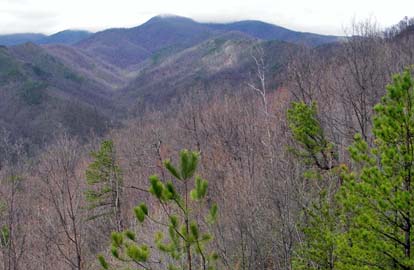 
On April 12, six adventurous hikers ignored the weather forecast and began the climb to Glass Rock Knob up Heartbreak Ridge Trail. So began the rescheduled hike to reach Iron Mountain Ridge in the Grandfather - Toecane Ranger District. Within one hour the rain stopped and the sun shone on the trek. The views of the entire West Ridge from Montreat were magnificent from Licklog Knob and from the rock outcrop near Glass Rock Knob where Blue Ridge Pinnacle was awesome. Along the trail was the grandest display of trailing arbutus in white and pale pink blooms. Following lunch we proceeded across the connector to the Iron Mountain Ridge Trail, now made passable, to reach the sharp ridge with views of Green Knob, Walker Knob, Hobbs Knob and Mackey Mountain. Further along the climb to the summit of Rocky Mountain provided a spectacular view in clear air of the Blacks from Gibbes and Clingmans Peak to Table Rock and Sitting Bear in the distance. The group negotiated the long steep descent from the ridge with skill to reach Jarrett Creek. In a more relaxed pace the last climb to reach Heartbreak Ridge Trail closed the loop. The sun was shining warmly and the afternoon was beautiful. The group opted to accept a lagniappe (a small gift given to a customer by a merchant at the time of a purchase - ed.) and followed a short trail from the junction to an outstanding rock outcrop from where the entire route of Heartbreak Ridge could be seen with the pattern of the railroad coming out of Jarrett Tunnel. Warmed by the sun and the rest, the group returned down from Heartbreak Ridge to cross Pritchard Creek and reach the trailhead. Stuart
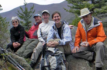
ALL DAY NO. A0802-201 Apr. 13
MST: NC 80 over Woods Mtn. to Woodland Park 8:00 AM
Hike 12.2, Drive 85, 2600 ft. ascent, Rated A-AA
Don Walton, 828-654-9904, donwalton@bellsouth.net
This new CMC hike will hike a little-traveled and scenic section of the MST over Woods Mtn. and on to US 221,with seldom-seen views of the Blacks and Mt. Mitchell. Long descent. Car shuttle. Second meeting place: Little Siena Restaurant at intersection of US 70 and NC 80 at 8:30 AM. Topos: Celo, Little Switzerland
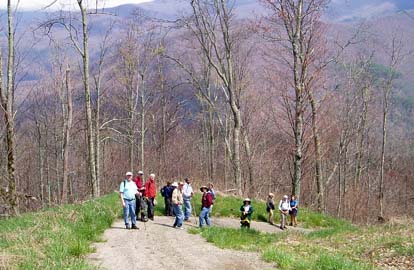
 Nine hikers gathered for what was predicted to be a cold, rainy, snowy and windy day. True to NC weather predictions it turned out to be mostly a warm and clear day. We started hiking at NC 80 on the MST at 9:15 moving steadily towards Woods Mtn about 6 miles out. We left the MST and arrived at the old Woods Mtn. Tower Site for lunch. We were met at lunch by our two car spotter hikers and all headed toward Toms Creek after lunch. We enjoyed views of the Blacks from the South side and Table Rock by Linville Gorge. This hike was different then the listed one but is a nice 2000 up and 3500 down hike in the Marion area. Don. Photo by Carroll Koepplinger. Nine hikers gathered for what was predicted to be a cold, rainy, snowy and windy day. True to NC weather predictions it turned out to be mostly a warm and clear day. We started hiking at NC 80 on the MST at 9:15 moving steadily towards Woods Mtn about 6 miles out. We left the MST and arrived at the old Woods Mtn. Tower Site for lunch. We were met at lunch by our two car spotter hikers and all headed toward Toms Creek after lunch. We enjoyed views of the Blacks from the South side and Table Rock by Linville Gorge. This hike was different then the listed one but is a nice 2000 up and 3500 down hike in the Marion area. Don. Photo by Carroll Koepplinger.
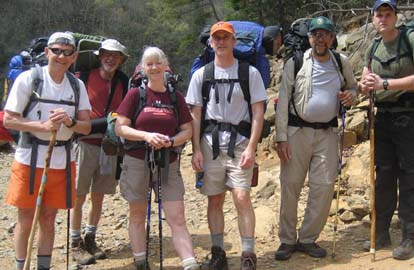
ALL DAY NO. A802-164 Apr. 20
Hawkbill Creek - Snowball Circuit 8:30 AM*
Carroll Koepplinger, 828-667-0723. carrollkoepp@bellsouth.net
Hike 8.4, drive 50, 2800 ft. ascent, Rated B-AA
*Note later start time. This great wildflower hike will begin alongside Hawkbill Creek, then climb a short but strenuous bushwhack up to Hawkbill Rock and Little Snowball Mtn., the site of an old fire tower, and then down to the starting point. The wildflowers and ramps have been spectacular every time CMC has taken this hike. The hike will also feature panoramic views from Hawkbill Rock and Little Snowball and enjoyable open-woods, off-trail hiking. The pace will be moderate. Topo: Craggy Pinnacle
 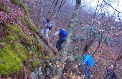
Good old mountain weather! What started out at Westgate as skies starting to clear quickly changed to cloudy & threatening rain by the time we reached the trailhead for the hike to Hawksbill Creek. That wasn’t about to deter 15 determined hikers including three first time hikers and one returning hiker who hadn’t hiked with the club for a few years – welcome and look forward to having you on future hikes.
We left the trail head at 9:30 am and returned at 3:45 pm after an 8.4 mile hike with approximately a 2,430 ft elevation ascent. The most strenuous part of this hike is the 400 ft bushwhack from the Hawksbill Creek to the Snowball Trail. Wow! What a great group of bushwhackers on a climb that was tough and somewhat wet and slippery from the previous rainfalls. We had lunch at Hawksbill Rock and proceeded to Little Snowball Mtn. with all the imaginary views that one could ponder on. As we left Little Snowball the fog and clouds began to break and low and behold the last few miles of the hike the skies were clearing with a good amount of sunshine.
Our flower experts counted 43 different varieties of flowers along with a good crop of ramps. Unfortunately it was a little early for the Indian Paint Brushes & Showy Orchids. Who can complain about only 43 varieties? Carroll. Photo on left by Bruce Benter, on right by Charlie Ferguson.
Half Day Sunday
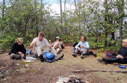
HALF-DAY No. H0802-171 Apr. 13
Cat Gap Loop *1:30 PM
Hike 5, Drive 40, 1100 ft. ascent, Rated C-B
Nonmembers, call leader, Lucy Prim, 828-693-6580, lucette32@mchsi.com
P400 *Meet at Westgate at 1:30 PM to form carpools, and meet leader at Fish Hatchery parking lot at 2:10 PM. This is a moderate loop hike on the Cat Gap Loop Trail.
The hike on April 13, 2008 along Cat Gap Loop was great. The weather was beautiful--lovely big clouds and a cool little breeze and even snow flakes when we got to the top of our trail! We had 11 people and it was a really nice, happy group. Lucy
HALF-DAY No. H0802-511 Apr. 20
Florence Nature Preserve 1:30 PM
Hike 5, Drive 40, 600 ft. ascent, Rated C-C
Nonmembers, call leader, Don Walton, 828-654-9904, donwalton@bellsouth.net
Tour the 600+-acre Florence Nature Preserve that may become part of a larger plan to establish a new NC State Park in the Lake Lure area. This is an easy loop hike through lady slippers and other spring flowers. Second meeting place: Parking lot adjacent to Nita’s Grocery in Gerton, near the preserve, at 2:00 PM.
On Sunday the 20th of April we had 24 hikers on the half day hike in
the Florence Nature
preserve. The hike was a little over 4 miles in length and covered
the blue and red trails
with a couple of short side trips for views. The hikers found the
Florence Preserve offered
a very nice hike and all had a good time. There is a large majestic
fir tree in the meadow
where the blue trail and red trail intersect. There are no other
such trees in the vicinity.
On an earlier hike we all wondered what kind of tree it was and where
it come from. At that
time one of the hikers took a clipping of it and presented it to the
NC Arboretum for identification.
That person was with us on Sunday and was able to provide the
information about the tree.
It is a Chinese Fire tree. Apparently the Biltmore people obtained a
number of these trees and
someone planted one in the meadow. In spite of it being an invasive
species, it is a great addition
to the forest and there is no sign of it spreading little Chinese
Fire trees around the meadow. Barth.
All Day Wednesday
WEDNESDAY NO. W0802-104 Apr. 16
Wolfe Ford, High Falls & Rigby Cutoff 9:00 AM
Hike 7.3, Drive 60, 900 ft. ascent, Rated A-C
Charlie Ferguson, 828-333-5165, ccf108@gmail.com
P400 From the gauging station on the South Mills River, we'll hike this mostly level trail to High Falls, then cross the footbridge at Wolfe Ford. We'll take the Rigby Cutoff (named for CMC hiker Ed Rigby) near Squirrel Gap to return to the trailhead. Two small stream crossings. Second Meeting Place: Pisgah Ranger Station at 9:35 AM. Topo: Pisgah Forest; also Nat'l. Geo. PRD map #780
 Twenty one hikers gathered at the Gauging Station, at the east end of the Pink Beds. There were lots of tents there, probably belonging to fishermen. The weather was cool and clear. We began walking south on the South Mills River Trail about one mile to the bridge crossing the river. From there we walked 0 .8 mile on that trail and turned left onto an unnamed narrow trail that runs along the crest of Grassy Ridge. It dropped fairly steeply near to where Clawhammer Creek flows into the river. We turned left onto an unnamed trail that runs north along the river for about a half mile. Along the way we saw another big group of fisherfolk tents on the other side. Twenty one hikers gathered at the Gauging Station, at the east end of the Pink Beds. There were lots of tents there, probably belonging to fishermen. The weather was cool and clear. We began walking south on the South Mills River Trail about one mile to the bridge crossing the river. From there we walked 0 .8 mile on that trail and turned left onto an unnamed narrow trail that runs along the crest of Grassy Ridge. It dropped fairly steeply near to where Clawhammer Creek flows into the river. We turned left onto an unnamed trail that runs north along the river for about a half mile. Along the way we saw another big group of fisherfolk tents on the other side.
We stopped at High Falls which was about 15 feet high and had a good flow of water cascading down. Most hikers stayed on the trail to eat lunch, but a few went down very steep steps to rocks along the river. We hiked back to Clawhammer Creek which was about 10 feet wide with only a few scattered stepping stones. Jeanie and I got into the water and started moving rocks. Meantime most people changed into water shoes. Some crossed on the stepping stones and some walked through the water. The water was nice and cool on our hot feet. The air temperature was about 60 degrees at this point.
After changing back to our hiking shoes, we went a few hundred feet to Wolf Ford and crossed on the swinging bridge to the head of the Squirrel Gap Trail. It starts with a fairly steep 200 foot climb. After 0.9 mile we stopped to let everyone catch up, and turned left onto an old trail whose name no one remembers, but we call it the Rigby Cutoff, after the CMC leader that rediscovered it. The trail still has old red blazes but sometimes its easy to lose track of them. The trail starts with a pretty steep 125 foot climb over a tenth of a mile, but then became easier. A lot of the hike was on an obvious trail. Occasionally it would disappear into brush or blow downs and we would have to find it on the other side. There were short sections that were a bit like a bushwhack but not to uncomfortable. The trail gradually sloped back down to the river where we met another narrow unnamed trail on the east side of the river and took it back to the South Mills River Trail near the bridge we had first crossed. A second stream, Billy Branch, did not require that anyone take their boots off for the crossing. Then there was a short walk back to our cars. One hiker was quite tired at the end of the hike and remarked that it was probably too much for her first hike after not hiking in awhile. The weather was great and most people tolerated the hike leader quite well.
Charlie Ferguson. Photo by Ted Connors.
WEDNESDAY NO. W0802-033 April 23
Ramsey Cascades 8:30 AM
Hike 8, Drive 165, 2100 ft. ascent, Rated B-AA
Ashok Kudva, 828-698-7119, ashok.kudva@mchsi.com
900M The drive and effort are a small price to pay for the reward of one of the classic hikes in the Smokies. We will pass through a grove of old-growth tulip poplars on our way to sixty-foot high Ramsey Cascades, located in a rich forest. Showy Orchis, Dutchman’s Breeches, Trillium and other wildflowers will be in bloom. Optional post hike dinner, probably at Bear Creek Grille. Second meeting place: Pilot Truck Stop at exit 24 off I-40 at 9:00AM, but call the leader first. Topo: Mt. Guyot; also Nat’l. Geo. GSMNP map #229
All-day hikes submitted by Bruce Bente 692-0116, bbente@bellsouth.net . Driving distance is round-trip from Asheville. All Saturday and Sunday hikes assemble at Westgate Shopping Center near I-240 UNLESS OTHERWISE NOTED.
Half Day hikes submitted by Paula Robbins 828-687-1651 paularww@bellsouth.net and Lucy Prim 828-693-6580 lucette32@mchsi.com. Wednesday Hikes are submitted by Charlie Ferguson, 828-398-0213 ccf108@gmail.com and Ann Gleason, 828-859-9387,
gleason.ann@gmail.com .
The meeting place for each hike will be designated by the hike leader and will appear in the hike description.
Driving mileage will be listed, round trip, from the first designated meeting place.
Leaders: Mail please mail your sign-up sheets. Meet at Westgate unless otherwise noted. |
 CMC Bi-Weekly Hike News