Looking Ahead..
All Day Saturday and Sunday
SATURDAY NO. A0803-367 Aug. 30
Art Loeb, Grassy Cove Ridge to Bridges Camp Gap *8:30 AM
Hike 8.5, Drive 65, 1650 ft. ascent, Rated A-A
Becky Smucker, 828-298-5013, bsmucker@charter.net
P400, SB6K *Note later start time. Beginning with a climb up to Black Balsam (6214 ft.) we’ll follow the ridgeline to Tennent Mtn (6040 ft.) and Ivestor Gap. Then we’ll hike down Grassy Cove Ridge to the Big East Fork of the Pigeon River. Two stream crossings, one or both of which will be wet. From there we’ll hike to Skinny Dip Falls, and then end at Bridges Camp Gap. Car shuttle. This is a Wilderness area hike limited to ten people. Please contact hike leader to reserve your place. Second meeting place: Cold Mtn. Overlook on BRP at 9:10 A.M. Topo: Shining Rock; also Nat’l. Geo. PRD map #780
ALL DAY NO. A0803-368 Aug. 31
Bradley Creek & Riverside Stream Crossings *8:30 AM
Hike 8, Drive 70, 650 ft. ascent, Rated B-C
Charlie Ferguson, 828-333-5165, ccf108@gmail.com
P400 *Note later start time. This is our biennial fun water hike. There are about 25 wet stream crossings, but the terrain is almost level and you will enjoy the beauty of the streams and the diverse flora nearby. Plan to hike in shoes/boots that don’t mind getting soaked and use two hiking poles. Car shuttle. Second meeting place: NC 280 at Turkey Pen Rd. at 9:00 AM. Topos: Pisgah Forest, Dunsmore Mtn.; also Nat’l. Geo. PRD map #780
Scouting Report: The trail marker at the beginning was missing but the scout went fine. Jay Bretz and Rich Sampson went on the scout. The weather was fine and the water was pretty shallow. The ascent was more like 750 feet in two short segments, one at the beginning and one at the end. Determining the correct count of stream crossings was the most controversial event. Two of the three of us decided that a squirell peeing on the trail did not constitute a stream crossing. We lost count. Boots were wet from beginning to end - nothing particularly deep. There is a 40 minute car shuttle at the beginning and end. We will make sure that we have enough cars at the end to bring everyone back to the beginning to get the rest of the cars, so that we don't have to drive cars back to the end to pick others up. A very pleasant hike.
ALL DAY NO. A0803-241 Sept. 7
Mt. Kephart via Sweat Heifer Creek Trail 8:00 AM
(strenuous)
Hike 12.8, Drive 140, 1800 ft. ascent, Rated A-AA
Carroll Koepplinger, 828-667-0723, carrollkoepp@bellsouth.net
SB6K, 900M This hike is designed to visit two of the best scenic overlooks in the Smokies, Jumpoff and Charlies Bunion and to climb Mt. Kephart (6217 ft.). From Newfound Gap, we will hike on the AT to Mt. Kephart and the Jumpoff, and from there to Charlies Bunion. After lunch, we will return via the AT, and then down the Sweat Heifer Creek and Kephart Prong Trails. Second meeting place: Rear of Maggie Valley Post Office parking lot, but call leader first. Car shuttle. Topos: Clingmans Dome, Mt. Le Conte, Mt. Guyot, Smokemont; also Nat’l. Geo. GSMNP map #229
ALL DAY NO. A0803-520 Sept. 7
Clawhammer Via Pressley Cove *9:00 AM
(moderate)
Hike 7.7, Drive 70, 2400 ft. ascent, Rated B-AA
Charlie Ferguson, 828-333-5165, ccf108@gmail.com
P400 *Note later start time. Meet at Westgate at 9:00 AM to form carpools, and meet leader at Pisgah Ranger Station at 9:35 AM. This hike will start with a steep climb on the Pressley Cove Trail, then finish the climb on the Black Mtn. Trail. Great views at lunch from the Clawhammer overlook. Short car shuttle. Topo: Pisgah Forest; also Nat’l. Geo. PRD map #780
--Back to Top
Half Day Sunday
HALF-DAY No. H0803-490 Aug. 31
Craven Gap to Folk Art Center *1:00 PM
Hike 5.4, Drive 11 miles, 750 ft. ascent, Rated C-C
Nonmembers, call leader, Renate Rikkers, 828-298-9988, rerikkers@aol.com
*Note early start time, and that the only meeting place is the back parking lot of the Folk Art Center off the BRP. A pleasant hike along the Mountains-to-Sea Trail, with a gradual 1640 ft. descent.
HALF-DAY No. H0803-615 Sept. 7
Black Balsam Loop via Graveyard Ridge Trail & ALT *12:30 PM
Nonmembers, call leader, Marcia Bromberg, 828-505-0471, mwbromberg@yahoo.com
P400 *Note early start time. Begin at FS 816, north on MST to Graveyard Ridge Trail. Left on Graveyard Ridge Trail to Ivestor Gap. Return on Art Loeb over Tennant and Black Balsam. 6 miles. We should see blueberries along the way. Also, great views! Second meeting: Pisgah Inn, north end of parking lot, at 1:00PM.
--Back to Top
All Day Wednesday
WEDNESDAY NO W0803-091 Sept. 3
Blacks South of Mt. Mitchell 8:00 AM
Hike 9, Drive 90, 2000 ft. ascent, Rated A-A
Tom Sanders, 828-252-6327, tomary2@charter.net
SB6K From Mt. Mitchell we will follow the Old Mitchell Trail south with a bushwhack to climb Mt. Hallback (6320 ft.), then to 6571 ft. Mt. Gibbes and continuing to Potato Knob, with return by partially alternate route. You can also climb Mt. Mitchell to fill out your list of 6000+ ft. peaks. Second Meeting Place: Parking lot adjacent to McDonalds at Exit 64 of I-40 at 8:20 AM. Topo: Mt. Mitchell, Montreat; also USFS. South Toe River, Mt. Mitchell & Big Ivy Trail Map
WEDNESDAY NO W0803-520 Sept. 10
Clawhammer via Pressley Cove *9:00 AM
Hike 7.7, Drive 70, 2000 ft. ascent, Rated B-A
Ashok Kudva, 828-698-7119, ashok.kudva@mchsi.com
P400 *Meet at Westgate at 9:00 AM to form carpools, and meet leader at Pisgah Ranger Station at 9:35 AM. This hike will start with a steep climb on the Pressley Cove Trail, then finish the climb on the Black Mtn. Trail. Great views at lunch from the Clawhammer overlook. Short car shuttle. Topo: Pisgah Forest; also Nat'l. Geo. PRD map #780
Looking Back...
All Day Saturday & Sunday
ALL DAY NO. A0803-044 Aug. 17
Lost Cove 8:00 AM
Hike 7.5, Drive 150, 1500 ft. ascent, Rated B-B
Les and Catherine Love, 828-658-1489, lesrlove@charter.net
Everyone enjoyed this hike in the Wilson Creek area last year, so we’re offering it again. It features spectacular waterfalls and the best swimming anywhere. Bring your bathing suit. Be prepared for several wet-foot stream crossings. Optional supper afterwards at Little Siena. Second meeting place: Parking lot adjacent to McDonald’s off I-40 at Exit 64 at 8:20 AM. Topo: Grandfather Mtn.; also USFS Wilson Creek map and Nat’l. Geo. Linville Gorge map #779
 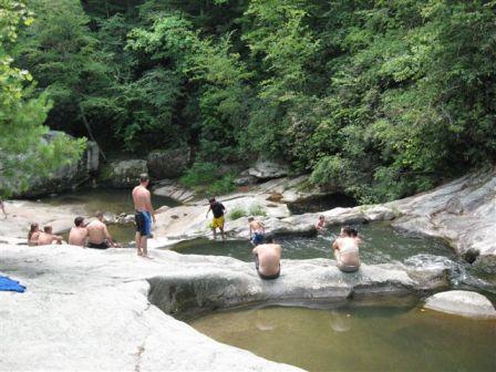
--Photos by Steve Morrell
Only 9 people showed this year for the annual Wilson Creek Area swim. I think we'll skip it for a few years. There were 2 first time hikers, Steve and Dan, who also want to get started doing trail maintenance. It was a beautiful day, high of around 80, and it had rained very hard for 3 hours during the night according to the campers we saw. This really helped with the dust on the 7 miles of gravel road coming in. We swam and ate lunch for 1 1/2 hours at Cragg Prong, then swam again at Hunt Fish Falls, when we got back to it around 3:30. We enjoyed watching 3 snakes laying in the waterfall catching small fish as they tumbled by.
Most of us then enjoyed a great meal at Little Sienna, learing about the new ownership and the retirement of Mamma and Pappa--Les and Catherine Love
ALL DAY NO. A0803-369 Aug. 24
Buckeye Gap - Gage Bald – Bear pen Gap *8:30 AM
Hike 8, Drive 80, 1200 ft. ascent, Rated B-B
Tom Sanders, 828-252-6327, tomary2@charter.net
P400 *Note later start time. We will start by hiking a section of the MST that leads through a lush forest of spruce and birch. The forest floor is covered with mosses and ferns. At Wet Camp Gap with a field of blooming phlox, a side trail will be followed to Gage Bald with its great views. We will hike through areas that in past years have yielded abundant blueberries and will stop to do some picking if we find them. Short car shuttle. Second meeting place: BRP Cold Mtn. Overlook at 9:10 AM Topo: Sam Knob; also Nat’l. Geo. PRD map #780
Seventeen people, most attracted by the prospect of blueberries, showed up for this hike. We began at Rough Butt Bald Overlook on the Parkway and followed an exceptionally beautiful section of the MST across Haywood Gap to the first picking on the side of Rough Butt Bald. We then proceeded on to Gage Bald, though several declined the steep ascent to pick in the open area in the gap. Some lunched there, others on top of Gage Bald, where we enjoyed good views, even though there were high clouds. The blueberries in all three places were good, though not exceptionally large as they sometimes are, and most people picked at least a quart. There were also lots of small blackberries which when fully ripe were quite tasty. We went out on the MST, ending at Bear Pen Gap, where we had stashed most of the cars. This is a good blueberry hike, just under 6 miles, thus allowing ample time to pick. The weather was good, with the high clouds keeping things reasonably cool.--Tom Sanders
--Back to Top
Half Day Sunday
HALF-DAY No. H0803-587 Aug. 17
Catawba Falls *1:00 PM
Hike 4, Drive 40, 600 ft. ascent, Rated C-C
Nonmembers, call leader, Becky Elston, 828-749-1886, belston@cytechusa.com
*Note early start time. Since the 1870s when Rufus Morgan photographed the Catawba Falls, people have hiked along the Catawba River to view these spectacular waterfalls. After years of being off-limits, the falls are now on their way to becoming open to the public. Second meeting place: Parking lot adjacent to McDonald’s at Exit 73 (Old Fort) off I-40 at 1:30 PM. Topo: Black Mountain.
HALF-DAY No. H0803-437 Aug. 24
Slate Rock Creek - Slate Rock Ridge – Pilot Cove *1:30 PM
Hike 5, Drive 40, 1300 ft. ascent, Rated C-B
Nonmembers, call leader, Lee Belknap, 828-698-9394, rivergypsy@sprintmail.com
P400 *Meet at Westgate at 1:30 PM to form carpools, and meet leader at Pisgah Ranger Station, US 276 at 2:05 PM. This is a moderate hike up beautiful Slate Rock Creek and along Slate Rock Ridge. The hike includes waterfalls and a great view of Pilot Rock from the ridge top. Short car shuttle.
25 hikers including the leader ventured into the Pisgah Forest to hike up Slate Rock Creek on the Pilot Cove - Slate Rock trail (FS102) and down Slate Rock Ridge on the Pilot Cove Loop Trail (FS103). Knowing that there are three trails with the word “Pilot” in them along the Yellow Gap Road, and two of them were opposite ends of the same trail, I attempted to very carefully find the proper trail head. Unfortunately, I managed to “carefully” misread an earlier trail sign and ended up at the wrong end of the intended hike. Since the trail sign had the right name on it, and some of the campsites nearby looked right (they all look the same don’t they?), had no particular reason to doubt where we were. We ran a shuttle to an unconnected trail and started up what was supposed to be Slate Rock Creek.
Very soon in the hike a very familiar (to me) fork in the trail was encountered. And I just couldn’t believe it. Surely this was just a reroute around a washout – I could have sworn that was farther up Slate Rock Creek… Surely I couldn’t have started the hike from the wrong trailhead! But I had. Very embarrassing - especially as a first time hike leader. A few hundred yards more and my mistake was obvious. I could no longer deny it. Luckily, the fork was part of a shorter loop trail I’d done many times in the past so it was easy to change plans to a shorter hike, and it still included the spectacular view of Pilot Rock from Slate Rock Ridge. So we hiked the up the steep part of the Pilot Cove Loop Trail (FS103) to Slate Rock Ridge, snacked at the view point, and continued up the ridge until we intersected the Pilot Cove-Slate Rock trail (FS102) and went left, down to Pilot Cove and back to the fork in the trail and the single waiting van. As we descended Pilot cove we could make out the clearings through the woods caused by beaver ponds off to our left.
Lessons learned: There is an old saying: The best excuse is one you can use over and over. The excuse I’ll try to use here is that this was the first CMC hike I’ve led. My first big mistake was not reading each trailhead sign even closer than I already was attempting to do. My second mistake was not reading the sign again when we left the cars. I needed to get out of my vehicle to walk around the parked car and read it. The third mistake I made was to let the discovery of the unexpected fork in the trail distract me from my other duties. While I was desperately hoping it was just a re-route, I failed to stop and wait for everyone to catch up. Some of the hikers behind me had a chance to start down the wrong fork. Luckily we hadn’t gone far and someone figured it out quickly and they were able to get back on the proper track right away. There were also a number of factors that contributed to a later start from the trailhead than expected. We still had time, but wouldn’t have ended the hike until around 7. The shorter hike helped this problem. I apologize to anyone who may have been disappointed at not seeing Slate Rock Creek and encourage folks to go there sometime (and the best time will be springtime when the waterfalls are flowing better).
One other note: There is an unmarked trail (former logging road) that supposedly could have taken us to the cars, but without having been on it before, the risk didn’t seem worth it and we simply undid the shuttle at the end of the day instead.--Lee Belknap
--Back to Top
All Day Wednesday
WEDNESDAY NO W0803-612 Aug. 20
Flat Laurel Creek - Devil's Courthouse *8:00 AM
Hike 7.5, Drive 70, 500 ft. ascent, Rated B-C
Becky Elston, 828-749-1886, belston@cytechusa.com
P400, SB6K *Meet at Westgate at 8:00 AM to form car pools, and meet hike leader at Cold Mountain Overlook on BRP at 8:40 AM. We will go south on the Art Loeb Trail and view Pilot Mountain from an off trail overlook and then to Little Sam Trail north to have lunch on Flat Laurel Creek. Then south to Devil's Courthouse and back to the cars. Possible optional side trip to SB6K Chestnut Bald. Should be cooler at the 5000 feet elevation. Topos: Shining Rock, Sam Knob; also Natl. Geo. PRD map #780
We had a beautiful day and went in on the Art Loeb/MTS trail to Devils Courthouse. We changed the hike from the write up and went by Flat Laurel Creek and to the parking lot for a short car shuttle via Little Sam. It was hard pulling the blackberry pickers back on the trail.--Becky Elston
WEDNESDAY NO W0803-337 Aug. 27
Shining Rock from Black Balsam *8:30 AM
(difficult)
Hike 11, Drive 65, 1500 ft. ascent, Rated A-A
Charlie Ferguson, 828-333-5165, ccf108@gmail.com
SB6K, P400 We will take the Art Loeb Trail from FS 816 to Shining Rock (6040’), climbing Black Balsam (6214’), Tennent Mtn. (6040’) and Grassy Cove Top (6040’) along the way. This will be your chance to bag four SB6K peaks while enjoying beautiful views covering the area from Pilot Mtn. to Cold Mtn. We’ll return via the Ivestor Gap Trail to get a different perspective on the same area. *Wilderness area hike limited to 10 people. Please contact hike leader to reserve your place. Second Meeting Place: BRP Cold Mtn. overlook at 9:10 AM. Topo: Shining Rock, Sam Knob; also Natl. Geo. PRD map #780.
Due to an irrational fear of the weatherman the hike to Shining Rock was cancelled. Well, the weather looks like it would have been OK for a hike. Up at 5-6000 feet there would be two layers of clouds, one above and one below us which would look pretty spectacular. I have the list of people who had reserved spaces for this hike. I am re-scheduling this hike for Wednesday September 17th - we will meet at Westgate at 8:30. Call or email me if you want to go on this hike. Charlie - 828-333-5165, ccf108@gmail.com
All-day hikes submitted by Bruce Bente 692-0116, bbente@bellsouth.net
. Driving distance is round-trip from Asheville. All Saturday and
Sunday hikes assemble at Westgate Shopping Center near I-240 UNLESS
OTHERWISE NOTED.
Half Day hikes submitted by Paula Robbins 828-687-1651 paularww@bellsouth.net and Lucy Prim 828-693-6580 lucette32@mchsi.com. Wednesday Hikes are submitted by Charlie Ferguson, 828-398-0213 ccf108@gmail.com and Ann Gleason, 828-859-9387,
gleason.ann@gmail.com .
The meeting place for each hike will be designated by the hike leader and will appear in the hike description.
Driving mileage will be listed, round trip, from the first designated meeting place.
Leaders: Mail please mail your sign-up sheets. Meet at Westgate unless otherwise noted. |
 CMC Bi-Weekly Hike News