|
All Day Saturday & Sunday
ALL DAY No. A0804-589 Dec. 21
Shut-in Trail & Lake Powhatan loop 8:30 AM*
Hike 9.6, Drive 15, 1600 ft. ascent, Rated A-A
Tom Sanders, 828-252-6327, tomary.avl@gmail.com
P400 *Note later start time. This loop follows the Shut-In Trail south, then descends Sleepy Gap Trail, skirts Lake Powhatan and finishes with three miles on the Bent Creek Trail with a dirt road connecting parts of the trail. Second meeting place: BRP French Broad Overlook at 8:45 AM. Topos: Asheville, Dunsmore Mtn., also Nat’l. Geo. PRD map #780
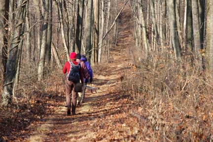 When two of us gathered at Westgate for this hike, the weather was cold and especially windy. At French Broad Overlook, we picked up two more, the wind was dying down, and we set off. Ascending the Shut-In Trail the wind almost disappeared, the sun began to come out, and suddenly we realized that this was going to be one of these perfect winter days for a hike. The wind had blown away the clouds, and this enhanced the excellent views along the ridge. When two of us gathered at Westgate for this hike, the weather was cold and especially windy. At French Broad Overlook, we picked up two more, the wind was dying down, and we set off. Ascending the Shut-In Trail the wind almost disappeared, the sun began to come out, and suddenly we realized that this was going to be one of these perfect winter days for a hike. The wind had blown away the clouds, and this enhanced the excellent views along the ridge.
After 4.5 miles we descended on the Sleepy Gap and Pinetree Trails to Lake Powhatan, where we had lunch. We then continued on the Bent Creek Road, taking the footpaths along the creek, and then back to the trailhead. This is an excellent hike, especially for someone living near Asheville. It is only about 10 miles from the city. At 9.5 miles it is a good distance,and it has enough uphill to provide a good workout. Unfortunately, many members probably declined to go along with us because they thought the weather might be bad, but it wasn't. Too bad! We had a really good time. Tom. Photo by Ted Connors.
SATURDAY No. A0804-246 Dec. 27
Around Coffee Pot Mtn. 9:00 AM*
Hike 7.5, Drive 50, 1400 ft. ascent, Rated B-B
Michael and Kathy Cornn, 828-698-3672, knkyle@yahoo.com
P400 *This moderate after-Christmas hike will start a bit later. Meet at Westgate at 9:00 AM to form carpools, and meet leaders at Trace Ridge parking area at 9:30 AM. We’ll circle Coffee Pot Mtn. by hiking up Trace Ridge Trail to Beaver Dam Gap on the BRP and returning on the Spencer Branch Trail, with a stop to see the freshly-dredged Hendersonville Reservoir and dam. Topo: Dunsmore Mtn.; also Nat’l. Geo. PRD map #780
Eleven hikers met at Westgate including two first time hikers with the club. We met two more hikers at the Trace Ridge trailhead parking area. From there we went up the Trace Ridge trail up to the Blue Ridge Parkway. The trial then meandered up and down along the ridge. Soon most hikers were shedding their extra clothing as the temperature rose. Lunch was at Beaver Dam Gap on the BRP, with great views but some wind. We ended lunch as the wind picked up speed. We returned the way we came until we reached the Spencer Branch trial. This trial goes by a well built beaver dam. There were a few streams to rock hop across, with only a few getting their boots wet. We ended the hike by passing the old Hendersonville Reservoir and then up to the cars. Michael. Photos by Ted Connors.
ALL DAY No. A0804-406 Dec. 28
Pink Beds to Clawhammer and Return *8:30 AM
Hike 8, Drive 86, 2300 ft ascent, Rated B-AA
Michael Cornn, 828-698-3672, mcornn@aol.com
P400 *Note later start time. We will climb from the Pink Beds (FS 477) to Club Gap. Then we take the Black Mt. Trail, climbing through Buckhorn Gap and along the ridge to the overlook at Clawhammer Mtn. for lunch and 180 degree views. Second meeting place: Side parking lot of Bi-Lo in Pisgah Forest at 9:00 AM. Topos: Shining Rock, Pisgah Forest; also Nat’l. Geo. PRD map #780
At Westgate one other hiker showed up and so did the rain. We decided that it was not a good day to hike. I went on to Bi-Lo to see if anyone was there. No one was there. Michael
NEW YEARS DAY NO. A0901-281 Jan. 1
Green River Gamelands *8:00 AM breakfast, 9:15 AM hike
Hike 6.5 or 8, Drive 70, 1300 or 1500 ft. ascent, Rated B-B
Bruce Bente, 828-692-0116, bbente@bellsouth.net
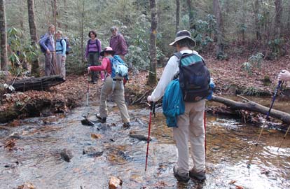
*Meet at Westgate at 7:30 AM to form carpools and meet leader at times above at the NE corner of the Cracker Barrel parking lot in Hendersonville (exit 53 on I-26). After breakfast, we’ll do our traditional New Year’s Day hike on a series of trails around the Green River Gamelands. We’ll hike down to and along the Green River, with a late lunch at the big rocks on the Green River, and then hike up and out on the Pulliam Creek trail. Short car shuttle. Topo: Cliffield Mtn.; also Map of the Green River Gamelands Trails
 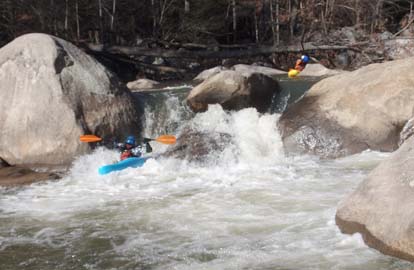
Our traditional New Year's Day hike in the Green River Gamelands was popular this year. 22 people came for a friendly breakfast and conversation at the Cracker Barrel, with good service from their great staff. With their help, we put 5 tables together in a long row to seat everyone together, arousing much interest from customers and staff as to who our group was. One waitress chuckled that she'd much rather be hiking with us than working. 28 people started and finished the actual hike in beautiful clear weather, enjoying the warm sun on a cold day as we hiked down to and then up alongside the Green River. At one point one hiker played hike-and-seek with us, which will result in a discussion at the next meeting of the Hiking Committee, but fortunately, it turned out well for everyone. Some folks stayed at the Pulliam Creek trail junction while the rest of the hikers went down to the big rocks for lunch. An added treat was watching two groups of kayakers maneuver around the rocks and disappear downstream.
The Pulliam Creek crossing was easy for everyone, with low water and the handrail log installed two years ago by CMC (see photo), and the handrail for the bridge at the trailend was good and sturdy. Bruce. Photos by Bruce Bente
ALL DAY NO. A0901-564 Jan. 4
Greybeard and Rocky Knob 8:00 AM
(strenuous)
Hike 9, Drive 40, 3400 ft. ascent, Rated A-AA+
Paul Benson, 828-251-1909, pdbenson@charter.net
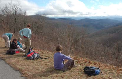
Come along for a good workout above Montreat, which will be even more challenging if there is snow at the higher elevations. We’ll climb up the Big Piney Ridge and West Ridge trails to Greybeard, then take the manway over to Rocky Knob for lunch. We’ll return via the Rocky Knob Trail to the Old Toll Rd. to Greybeard Trail.
Topo: Montreat
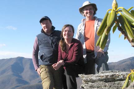 After some doubts about leading the hike because of rainy weather forecasts, I was encouraged by two avid hikers looking for adventure and exercise to go ahead in spite of almost certain bad weather. Fortunately, as is often the case, the weatherman was right about rain, (it drizzled all of about five minutes) but primarily wrong as the day was mostly sunny, beautiful and unseasonably warm. The hike was very strenuous starting with over a 3 hour and 3,000’ steady uphill climb to the summit of Greybeard Mountain, but rewarding with many beautiful views from the Seven Sisters ridgeline and Greybeard. The lunch spot on Rocky Knob offered grandstand views of the surrounding valleys and ridgelines (including the majestic Great Craggies and the southern end of the Black Mountain Range. Enjoying some much deserved relaxation in the warm sunshine made leaving difficult, but the short daylight encouraged us to be on the way before it got too late. The descent on the Greybeard Trail offered beautiful scenery of a different kind with lush woods and a cascading stream. We completed the hike right at 5pm, having spent about 8 wonderful hours on the trail. Paul. Picture by Paul Benson. After some doubts about leading the hike because of rainy weather forecasts, I was encouraged by two avid hikers looking for adventure and exercise to go ahead in spite of almost certain bad weather. Fortunately, as is often the case, the weatherman was right about rain, (it drizzled all of about five minutes) but primarily wrong as the day was mostly sunny, beautiful and unseasonably warm. The hike was very strenuous starting with over a 3 hour and 3,000’ steady uphill climb to the summit of Greybeard Mountain, but rewarding with many beautiful views from the Seven Sisters ridgeline and Greybeard. The lunch spot on Rocky Knob offered grandstand views of the surrounding valleys and ridgelines (including the majestic Great Craggies and the southern end of the Black Mountain Range. Enjoying some much deserved relaxation in the warm sunshine made leaving difficult, but the short daylight encouraged us to be on the way before it got too late. The descent on the Greybeard Trail offered beautiful scenery of a different kind with lush woods and a cascading stream. We completed the hike right at 5pm, having spent about 8 wonderful hours on the trail. Paul. Picture by Paul Benson.
ALL DAY NO. A0901-631 Jan. 4
Dupont Forest Hooker Falls P.L. #3 (3 Falls & 2 Lakes) *8:30 AM
(moderate)
Hike 9, Drive 80, 1200 ft. ascent, Rated B-B
Jay Bretz, 828-658-1220, williambretz1220@msn.com
WC100 *Note later start time. This hike goes to three of the best waterfalls and two lakes in the Dupont State Forest. We will be going to Triple and High Falls and then to Lake Dense. We will use the newly opened Conservation Road to get to the south part of the Little River, across the dam to Lake Julia. After lunch at Lake Julia we hike to the old airstrip, horse barn and then the beautiful cascade of water over Bridal Veil Falls. Second meeting place: Bi-Lo at Pisgah Forest at 9:05 AM. Topo: Standingstone Mtn.; also DuPont State Forest Map
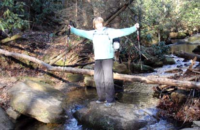
Four brave hikers set out on an overcast, misty but relatively warm morning to enjoy the beautiful sites of Dupont State Forest. These included High Falls, Triple Falls, Lake Dense, Lake Julian, old airstrip and Bridal Veil Falls. Within 45 minutes, the weather turned beautiful with gorgeous blue skies and temperatures rising into the 60's. Due to the recent rains, the falls where full of water and put on a grand display of power and beauty. The group took their time at each site including a 40 minute lunch break at Lake Julian. The creeks were full also. This made for a moderately difficult creek crossing just 1 mile from the end of the hike. This did not dampen our spirits. With wet boots we joyously finished a wonderful hike. What a beautiful day! Jay
Half Day Sunday
HALF-DAY No. H0804-429 Dec. 21
Hard Times Road to Rocky Cove Road to Bent Creek Road *12:30 PM
Hike 5, Drive 20, 500 ft. ascent, Rated C-C
Nonmembers, call leader, Laura Stallard, 828-697-1579
*Note early start time. We will hike in the Bent Creek area from the Arboretum recreation parking lot in an easy loop including the Hard Times Road to Rocky Cove Rd to Bent Creek Road. Second meeting place: Ingles parking lot across from Biltmore Square Mall on NC 191 at 1:15 PM; from there we will carpool with drivers who have Arboretum member parking privileges.
HALF-DAY No. H0804-500 Dec. 28
French Broad River to US 25 *1:00 PM
Hike 5.4, Drive 15, 900 ft. ascent, Rated C-C
Nonmembers, call leader, Paula Robbins, 828-281-3253, paularww@bellsouth.net
Note early start time. Meet at Westgate at 1:00 PM to form carpools, and meet hike leader at Ingles parking lot across from Biltmore Square Mall on NC 191 south of I-26 at 1:15 PM. A pleasant winter hike through the woods, parallel to the Blue Ridge Parkway between I-26 and US 25. Short car shuttle.
My hike was canceled. Only two people showed up and it was sprinkling, so they went for a walk at the Arboretum. Paula
HALF-DAY NO. H0901-295 Jan. 4
Pump Gap, AT Loop *12:30 PM
Hike 5, Drive 70, 1200 ft. ascent, Rated C-B
Nonmembers, call leader, Tom Sanders, 828-252-6327, tomary.avl@gmail.com
*Note early start time. From Hot Springs we will ascend on the Pump Gap Trail to the AT. We will then go south on the AT via Lovers Leap with outstanding views of the French Broad River, then hike back to Hot Springs.
We had an injury event about half way through the hike. Marcia Bromberg broke her right ankle. So, I and seven other CMC hikers stayed back with her and the other sixteen hikers went on to finish the hike with an appointed person, George Grunewald who carried my trail map with him. The seven who stayed back with me performed superbly well with assignments. The point man was Don Walton who cell phoned for rescue help. Afterward, he, Joe Burchfield, Heidi Saugen, and Nan Welsh hiked out and met the rescue teams and all hiked back up the trail with a stretcher and medical supplies.
Gail Lamb, myself, Linda McCrea, and Dwight McCarter stayed with Marcia. Our extremely helpful hikers helped carry the stretcher out and the ambulance met us at the woods exit on the dirt road at Pump Gap trail. Marcia was transported to St. Joseph's Hospital in Asheville. The rescue personnel were from three agencies: Madison County EMS; Country Volunteer Fire Dept.; and Hot Springs Volunteer Fire Dept. They did an outstanding job and perhaps the club could send "thank you" letters to them and, maybe, some sort of appreciative token. Tish, substituting for Tom Sanders.
Update: Marcia was operated on Tuesday January 7 and is resting comfortably. She now starts the long recovery process. We hope to see her back on the trail real soon.
All Day Wednesday
WEDNESDAY No. W0804-493 Dec. 17
Pine Mt. Loop II 9:00 AM
Hike 9, Drive 20, 1850 ft. ascent, Rated B-A
Barbara Morgan, 828-738-3395, bcmorg@hughes.net
P400 Hike up to Pine Mtn. from the Bent Creek side via Explorer loop, Chestnut Cove Trail and MST. Bushwhack up to Pine Mtn from BRP, then down other side to MST, down Ruth’s Ridge and the Lower Sidehill Trail to cars. Second meeting place: Ingles Parking lot across from Biltmore Sq. on NC 191 at 9:15 AM. Topos: Enka, Dunsmore Mtn.; also Nat’l. Geo. PRD map #78
Nine hikers turned out for the Pine Mountain II hike, despite ominous predictions of rain. The weather turned out to be wonderful, although being overly warm was a bit of a problem! Not what you'd expect for mid-December. The hike began off Bent Creek Road about 10:00, ascended through a matrix of trails, roads, and bushwhacks to the BRP and on to the summit of Pine Mountain. As the clouds were high and views were excellent, the group decided to go on out to Double Top for a relaxing lunch and a panorama of views to the SW. After lunch, we completed our loop with lots of bushwhacking and more portions of road and trail back to the cars parked at the intersection of Bent Creek Road and Cold Knob Road. Barbara.
WEDNESDAY No. W0804-545 Dec.24
Bent Creek #11 - Boundary Trail 8:30 AM
Hike 8.5, Drive 25, 1300 ft. ascent, Rated B-B
Stuart English, 828-883-2447, stuengo@citcom.net
P400 From Bent Creek Gap we will follow the MST to the Bent Creek Boundary Trail, on to Ingles Field Gap, to Ledford Branch Rd and down to Deer lake Lodge Trail and the Rice Pinnacle parking lot. Great winter views. Car shuttle. Second meeting place: Ingles parking lot across from Biltmore Sq. Mall on NC 191 at 8:45 AM. Topo: Dunsmore Mt., Skyland; also Nat’l. Geo. PRD map #780 and Bent Creek Trail map.
The hike for Wednesday, December 24, 2008 was canceled because of rain. Our apologies to the seven who showed up at the two meeting places, especially, Tracy Mitchell from Raleigh, who was in Asheville visiting and wanted to join us. Hopefully we will see you another time and on another hike, Tracy. Stuart.
All-day hikes submitted by Bruce Bente 692-0116, bbente@bellsouth.net . Driving distance is round-trip from Asheville. All Saturday and Sunday hikes assemble at Westgate Shopping Center near I-240 UNLESS OTHERWISE NOTED.
Half Day hikes submitted by Lucy Prim 828-693-6580 lucette32@mchsi.com.
Wednesday Hikes are submitted by Charlie Ferguson, 828-398-0213 ccf108@gmail.com and Ann Gleason, 828-859-9387,
gleason.ann@gmail.com .
The meeting place for each hike will be designated by the hike leader and will appear in the hike description.
Driving mileage will be listed, round trip, from the first designated meeting place.
Leaders: Mail please mail your sign-up sheets. Meet at Westgate unless otherwise noted. |
