CMC Bi-Weekly Hike Reports
April 17th, 2009 -- Looking Back
| Half Day Sunday Hikes |
| Wednesday Hikes |
All Day Saturday & Sunday ALL DAY NO. A0902-224 Apr. 5
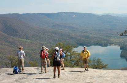
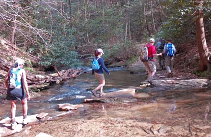
Photos by Ted Connors Between the weather, trail conditions, and the comradery, the April 5 Table Rock hike was awfully close to the perfect hike. The only downside was the inclement weather of the preceding weekends which required that I scout the hike the day before. We went up Table Rock first which was in the opposite direction of the club database. I think we all agreed that this was the best way to complete the hike because it put us on top of Table Rock right at lunch time, helped us avoid the afternoon traffic on the Table Rock trail, and saved our knees from the pounding coming off Table Rock. We had 11 hikers and we enjoyed excellent views from four rock outcroppings, most of which were perfectly timed after a strenuous climb. Special thanks to local club members Sim Wright and Mike Cannon for sharing some leading responsibilities when the previous day's scout took its toll. Additional thanks to the Table Rock staff and volunteers who have made significant trail improvements since I hiked this trail last summer. If anyone is interested in hiking this trail by moonlight, keep your eyes on the foothills trail website for the July 19 annual midnight hike led by interpretive ranger Scott Stegenga.--Jeff McGurk ALL DAY NO. A0902-304 Apr. 5 We started out on the expected wet terrain of the Shut-In Creek Trail. Unfortunately, about fifteen minutes into the hike, Lee Belknap got a"cramped" toe and wanted to leave the hike. He thought it was a"dislocated" toe, but, as later diagnosed at a medical center near his home, it was not dislocated. Tish, the hike leader drove him from the trailhead to her home and her husband drove him back to his car at Westgate and Lee was able to drive himself to a medical center. Jim Reel volunteered to lead the hike as far as Garenflo Gap. Tish later drove to Garenflo Gap and met the group there an hour later and led the hike the rest of the way. The group said they saw lots of pretty wildflowers in bloom along the Shut-In-Creek trail. We still had open views along the majority of the hike on the A.T. with dogwoods showing their flowers occasionally. We stopped at the Deer Park shelter and enjoyed reading the thru-hikers' journal and chatted with some who were resting there. One thru-hiker named "Greg" traveled past us on the trail and commented that the bear cables are superb!! Hats off to Howard!!!! Afterward, we enjoyed a lively and delicious potluck supper.--Tish Desjardins ALL DAY NO. A0902-333 Apr. 12
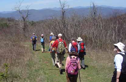
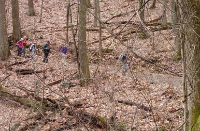
Photos by Bruce Bente On a sunny and beautiful day, 20 hikers showed up to hike over the ridges to Bearwallow Mtn. For the first time in many tries, the weather was NOT cold, windy or rainy. We first hiked steeply up to enjoy the view from Ferguson Peak, and then up through high meadows to enjoy a snack break on soft grass in an open meadow, while contemplating just how far away the summit of Bearwallow Mtn. appeared from our location. But not to worry, we arrived at the summit just after noon and everyone spread out on the big rock face to enjoy the view along with lunch. We returned by short-cutting down across the cow pasture with more great views, and then retraced our steps to Hickory Nut Gap. At the trailend, we had a chance to greet the Agers (property owners for part of the trail), who were out on a horseback trip up to Ferguson Peak.--Bruce Bente
HALF-DAY NO. H0902-316 Apr. 5 HALF-DAY NO. H0902-602 Apr. 12 Seventeen hikers, including several new CMC members, spent a sunny Easter Sunday afternoon on a four-mile walk along the Bent Creek Road and trails at the North Carolina Arboretum spotting and identifying wildflowers along the way. The leader was Paula Robbins, with assistance from Lucy Prim.--Paula Robbins WEDNESDAY NO. W0902-545 Apr. 1
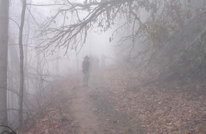
Photos by Stuart English I awoke to the sound of pouring rain Wednesday morning. Then checking the weather, it seemed the rain was going to be gone by 10 AM. It seemed we might have a shot. I had canceled this hike on a Wednesday in December because of rain. The hike was meant to be a view hike. Eleven brave hikers assembed for this hike and it was raining heavily as we drove to the trail head. As we started on the MST at Bent Creek Gap it was still raining. Before we got to the switchback up to Ferrin Knob, the rain had stopped. From there we followed the unmapped unmaintained Boundary Trail over several knobs of Stradley Mountain. We were in a heavy fog and the advertised views were invisible. Soon we were through climbing and on the actual mapped Boundary Road and the fog was even heavier. We had lunch at Ingles Field Gap and it began to clear. All of us decided, however, that walking ridge tops in the fog was a great experience all its own. As we wound our way back down into the big basin that is Bent Creek, I realized the lesson learned was that getting out in the woods was always different and always worthwhile.--Stuart English
WEDNESDAY NO. W0902-647 Apr. 8
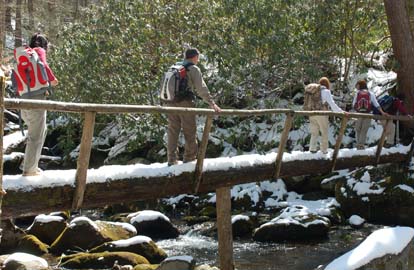
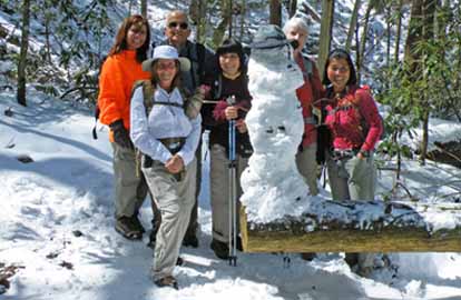
Photos by Ted Connors and Ashok Kudva For spring break, some seek sun; others seek snow. Today's hike had plenty of each. Favorite sights included icicles and a brilliant combination of green moss, snow and red berries on old logs. Last week's wildflowers were mostly covered with a carpet of white; but surprisingly, several brown mushrooms popped thru the snow. A snowman with cheerios eyes was built during one snack break and crowned with a trail hat for protection from the sun. Yours truly was greatly relieved when all hikers had successfully traversed the slanted, single log bridge, which was covered with three inches of snow. A delightfully sunny day for 11 hikers!--Janet Martin WEDNESDAY NO. W0902-518 Apr. 15 Reports for Wednesday hikes during the eNews publication week will appear in the following eNews--The Editor.
All-day hikes submitted by Bruce Bente 692-0116, bbente@bellsouth.net . Driving distance is round-trip from Asheville. All Saturday and Sunday hikes assemble at Westgate Shopping Center near I-240 UNLESS OTHERWISE NOTED. Half Day hikes submitted by Lucy Prim 828-693-6580 lucette32@mchsi.com. Wednesday Hikes are submitted by Charlie Ferguson, 828-398-0213 ccf108@gmail.com and Ann Gleason, 828-859-9387, gleason.ann@gmail.com . The meeting place for each hike will be designated by the hike leader and will appear in the hike description.
Driving mileage will be listed, round trip, from the first designated meeting place.
|