All Day Saturday & Sunday
ALL DAY NO. A0904-489 Nov. 22
Bad Fork - Trace Ridge Loop *8:30 AM
Hike 8, Drive 60, 2000 ft. ascent, Rated B-A
Les and Catherine Love, 828-658-1489, lesrlove@charter.net
P400 *Note later start time. From the Trace Ridge parking area, we will hike a short distance along a gravel road to the Bad Fork Trail, which will take us to the BRP on a steep 800 ft. ascent. From the BRP, we will have a long, steady climb to Ferrin Knob, then down to Beaver Dam Overlook for lunch. After lunch, we continue down the Trace Ridge Trail Topo: Dunsmore Mtn; also Natl. Geo. PRD map # 780
No one showed today at Westgate for our hike due to the forecast of rain.--Les & Catherine Love
ALL DAY NO. A0904-588 Nov. 29
Coontree Loop extended *9:00 AM
Hike 7, Drive 70, 1700 ft. ascent, Rated B-A
Marianne Newman, 828-257-2136, marianneln@att.net
P400 *Note later start time. We’ll hike the Coontree Loop, but extend it by including the Perry Cove and Bennett Gap trails, with a short road walk on FS 477 to connect the two. Second meeting place: Coontree Picnic area at 9:40 AM, but phone leader first. Topo: Shining Rock; also NatGeo map #780
Eleven hikers, including some newcomers, enjoyed a balmy day on a varied and interesting trail up, down, and around Coontree Ridge. The steep Perry Cove Trail, which was new to several of us, isn't heavily traveled and goes through fine woods, a beautiful cove, and an open meadow on its way down the back side of the ridge.--Marianne Newman
--Back to Top
Half Day Sunday
HALF-DAY NO. H0904-316 Nov. 22
Carl Sandburg Park *1:00 PM
Hike 5, Drive 60, Rated C-B
Nonmembers, call leader, Laura Stallard, 828-697-1579
*Note early start time. Meet at Westgate at 1:00 PM to form carpools, and meet leader at parking lot of Carl Sandburg Park at 1:45 PM. Traverse the same trails that poet/biographer Carl Sandburg enjoyed by climbing Big Grassy Mountain behind his farmhouse.
HALF-DAY NO. H0904-490 Nov. 29
Craven Gap to Folk Art Center *1:00 PM
Hike 5.4, Drive 11, 750 ft. ascent Rated C-C
Nonmembers, call Renate Rikkers, 828-298-9988, rerikkers@aol.com
*Note early start time, and that the only meeting place is the back parking lot of the Folk Art Center off the BRP. A pleasant hike along the Mountains-to-Sea Trail, with a gradual 1640 ft. descent.
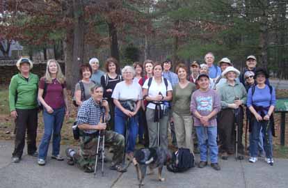
Photo by Virginia Hodge
On a balmy late-fall afternoon, 25 hikers enjoyed the no-leaves vistas along the MST from Craven Gap to the Folk Art Center. The sun, which had played peek-a-boo for most of the hike, shone on us as we snacked and chatted at Lunch Rock. It was hard to believe that December is only two days away! Submitted by the substitute hike leader.--Bobbi Powers
--Back to Top
WEDNESDAY NO. W0904-268 Nov. 18
Hospital Rock - Pretty Place – Rainbow Falls *8:00 AM
Hike 10, Drive 95, 2000 ft. ascent, Rated A-A
Brenda Worley, 828-684-8656, clworley@bellsouth.net
*Meet at Westgate at 8:00 AM to form carpools, and meet leader at Cracker Barrel at Exit 53 on I-26 at 8:30 AM or at Jones Gap State Park parking lot at 9:00 AM. We will hike up Hospital Rock Trail, then left to lunch at Pretty Place where you enjoy great views over the valley below. Continue on road, then climb down the escarpment on the Rainbow Falls Trail and back to the cars. Note: $2 fee entry fee per person at Jones Gap S.P. Topo: Standingstone Mtn.; also Mountain Bridge Wilderness map Bear hunting season - hike in groups and wear bright orange.
The hike was cancelled because of rain--Brenda Worley
WEDNESDAY NO. W0904-336 Nov. 25
Mt Cammerer from Big Creek *8:00 AM
Hike 12.2, Drive 110, 3300 ft. ascent, Rated AA-AA+
Tish Dejardins, 828-656-2191, desraylet@aol.com
900M, LTC *Meet at Westgate at 8:00 AM to form carpools, and meet leader at Big Creek Campground near Ranger Station at 9:30 AM. Note: The carpool from Westgate toBig Creek will take longer due to the I-40 closure. (New Driving directions: I-26 W to exit 19 - US Rt 25 (Marshall) through Hot Springs, continuing on US 25 to Newport TN. Left on US 321 to exit 435 I-40 E to exit 451 (TN); left under I-40 and follow to Big Creek campground and trailhead)
Eight of us hiked up the Chestnut Branch trail and the A.T. to the top of Mt. Cammerer where we had our lunch. It was a beautiful, calm, sunny day and the views were clear all the way over to Max Patch. We went via US 25 / 70, US 321 to I-40 east to Waterville Rd. The waterfalls along the way looked pretty with white caps against the lush green moss and ferns.--Tish Dejardins
WEDNESDAY NO. W0904-053 Dec. 2
East Fork Pigeon River *8:30 AM
Hike 7.5, Drive 74, 1200 ft. ascent, Rated B-B
Barbara Morgan, 828-738-3395, bcmorg@hughes.net
P400 Wilderness area, limit 10; contact leader for reservation. A stroll along one of WNC's most beautiful streams, the East Fork of the Pigeon River, which is often spectacular in the winter. We will ascend to Dark Prong for lunch and then return. Second meeting place: Big East parking area on US 276, north of BRP at 9:15 AM Topo: Shining Rock; also NatGeo map #780
Reports for Wednesday hikes during the eNews publication week will appear in the following eNews--The Editor.
--Back to Top
All-day hikes submitted by Bruce Bente 692-0116, bbente@bellsouth.net . Driving distance is round-trip from Asheville. All Saturday and Sunday hikes assemble at Westgate Shopping Center near I-240 UNLESS OTHERWISE NOTED.
Half Day hikes submitted by Lucy Prim 828-693-6580 lucette32@mchsi.com.
Wednesday Hikes are submitted by Charlie Ferguson, 828-398-0213 ccf108@gmail.com and Ann Gleason, 828-859-9387,
gleason.ann@gmail.com .
The meeting place for each hike will be designated by the hike leader and appears in the hike description.
Driving mileage is round trip, based on the first designated meeting place. Meet at Westgate unless otherwise noted.
|
