All Day Saturday & Sunday
SATURDAY NO. A1003-699 Aug. 28
Pisgah Loop II 8:00 AM
Hike 7, Drive 70, 1500 ft. ascent, Rated B-A
Jan Onan, 828-698-3237, janonan@bellsouth.net
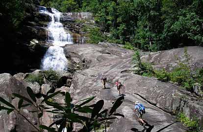
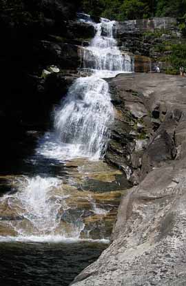
P400 Swimming hike! This loop hike will go down the boundary trail to the MST, then past Skinny Dip Falls (swimming stop) and up to Second Falls (more swimming), before returning to our cars. Possible blueberry sightings. Second meeting place: BRP Cold Mtn. Overlook at 8:40 AM. Topos: Shining Rock, Sam Knob; also NatGeo. map #780 and USFS Shining Rock & Middle Prong Wilderness map.
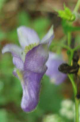 
Photos by Jan Onan
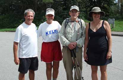
The leader, Jan, and Suzanne, and arrived at Cold Mountain Overlook at 8:35. Two more cars showed up with two more hikers, Jeff and Andres. We continued on to Long John Overlook and began our hike at 9:30. Someone had cleared all the blackberry brambles away from the path on the Boundary trail, so it was open. I had brought my clippers, but only needed them in one small spot. We were amazed to arrive at Skinny Dip Falls and find we were the only ones there! We swam or dunked our feet or just sat and soaked in the beautiful site, ate lunch and enjoyed each other and the emerging sunshine. After 45 minutes, we started hiking up to Second Falls where many others were enjoying the sunshine. After a half hour of swimming, or relaxing, we took off to check out the blueberries in Grave Yard Fields. There were more people there than blueberries! It was packed! After a few mouthfuls, we continued on to our cars. We finished around 3:30. It was a great hike. We came across one lone flower that no one could identify among the many late summer blooms (picture included). I thank Jeff for being both the sweep and the time keeper.--Jan Onan
SUNDAY NO. A1003-241 Aug. 29
Mt. Kephart via Sweat Heifer Creek Trail 8:00 AM
Hike 12.8, Drive 140, 2000 ft. ascent, Rated A-A
Tom Sanders, 828-252-6327, tomary.avl@gmail.com
SB6K, 900M This hike is designed to visit two of the best scenic overlooks in the Smokies, The Jumpoff and Charlies Bunion, and to climb Mt. Kephart (6217 ft.). From Newfound Gap, we will hike on the AT to Mt. Kephart and The Jumpoff, and from there to Charlies Bunion. After lunch, we will return via the AT, and then down the Sweat Heifer Creek and Kephart Prong Trails. Second meeting place: Rear of Maggie Valley Post Office parking lot, but call leader first. Car shuttle. Topos: Clingmans Dome, Mt. Le Conte, Mt. Guyot, Smokemont; also NatGeo map #317
Twelve people showed up for this hike in the Smokies. We drove via the BRP (for scenery but also shortness) to Highway 441, leaving half our cars at the end point of the hike, Kephart Prong Trail. We set off from Newfound Gap at about 10:00 am on the AT. The day was somewhat cloudy and hazy, but as the day wore on a light breeze helped clear things up. Our first stop was over 6000 plus Mt. Kephart, then on to the Jumpoff, with its spectacular views. We continued on to Charlie's Bunion for lunch. There were quite a few other hikers on the trail. About 1:00 pm we turned back on the A.T., up a 500 ft. elevation and then on to Sweat Heifer Trail. Recent trail improvement was evident all the way down that 3.7 miles. The upper part was a model of superb trail building: good steps of logs, small rocks, and dirt; rock work; and digging out the side of the trail to make it consistent in width. On the lower part the trail had been widened and smoothened with a small earth mover type vehicle. We in the CMC also have some models like the rock work under Potato Knob, but Sweat Heifer is worth hiking simply to see what other quality maintainers have done. The trail also features two waterfalls, the bigger one being especially notable. After a break at the Kephart Shelter, we made our way back to 441, arriving around 5:30 pm. We saw a yearling bear on Kephart Prong Trail. He stared at us for about 30 seconds while we stared at him. Finally, I guess he decided we outnumbered him so he took off into the woods.--Tom Sanders
SATURDAY Make-up NO. A1003-237 Sept 4
Plott Balsams 8:00 AM
Hike 9, Drive 90, 3400 ft. ascent, Rated A-AA+
Becky Smucker, 828-231-2198, bjsmucker@gmail.com
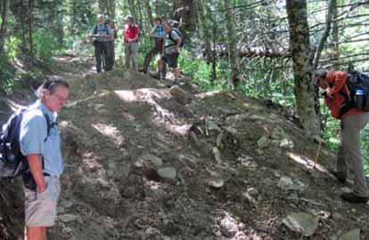
SB6K This is a redo of our aborted Memorial Day hike. We’ll climb four SB6K peaks and hope for spectacular views of more than fog this time. From Waterrock Knob (6292 ft.), we’ll follow a very rough, steep manway to Lyn Lowry (6240 ft.) and Plott Balsam (6088 ft.), then retrace our steps to the trailhead and hike to Yellowface (6032 ft.) and back. Expect rough, uneven “trail” and climbing over and under blowdowns on steep slopes. Wear long sleeves and pants. Second meeting place: rest area beyond Waynesville on US 23/74 at 8:30 AM, but contact leader. Topos: Hazelwood, Sylva North
Photos by Becky Smucker
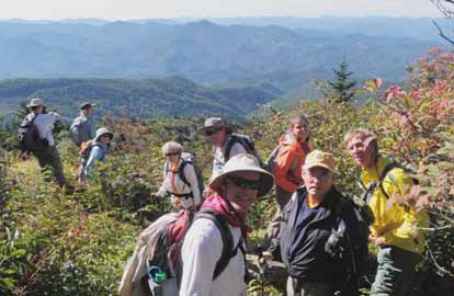
What a perfect day! This one really made up for the less-than-stellar attempt last Memorial Day. The morning was clear and cold, but the twelve of us were well warmed up by the time we reached the top of Waterrock Knob, and we stayed warm but comfortable in long pants and sleeves during the remainder of this strenuous hike. We shoved our way through the overgrowth, grazed on a few remaining blackberries and blueberries, admired the autumn flowers and mountain ash berries, and took time to absorb the never-ending views. The manway along the ridge required constant attention to footwork, a lot of climbing over and under, and some steep ups and downs, so we got a full-body workout. I heard comments of “Wow, a REAL TRAIL!” on the climb to Yellowface at the end of the day. Several baggers added four peaks to their SB6K list and knew they’d earned them. Will even found his lost shirt, so what more could we ask from one day?--Becky Smucker
SUNDAY NO. A1003-661 Sept. 5
Thompson River Scramble (Bernard Elias Favorite Hike series #5) *8:00 AM
(strenuous)
Hike 10, Drive 110, 2100 ft. ascent, Rated A-AA
Ted Snyder, 864-638-3686, tedsnyderjr@bellsouth.net
*Form carpools at Westgate, stop for additional hikers at Pisgah Forest Bi-Lo at 8:30 AM, and meet leader behind gas station at intersection of US 64 and NC 281 SOUTH at 9:15 AM. Thompson River and our final destination, spectacular Big Falls, are located within Nantahala Natl. Forest near Whitewater Falls. After a relatively easy 4-mile hike, the hike requires about a mile of scrambling through heavy growth before executing an exciting but somewhat precarious 400 ft. climb up the face of the rock next to the falls followed by a tricky wet stream crossing, and then an easier 3-mile hike back. Strenuous, but well worth the effort. Wear non-slip-sole shoes. In case of rain an alternate hike will be chosen. Topo: Reid
Photos by John Thompson
Our trip pulled out with a complement of sixteen. A slight morning chill was dissipated as the temperature rose to about 80 F under a clear sky. The High Falls of the Thompson River were flowing in full glory. The estimated total drop of the falls is 200 feet. Photos were made from an array of viewpoints. The rock on which we ascended beside the falls was dry, making that obstacle an easy one. Not so easy was the serious bushwhacking, both to reach the foot of the falls , and the travel upstream. It took our party the better part of three hours to claw our way through the thickets. A good crossing was chosen eventually, and everyone made it easily. The trip is correctly rated as strenuous. The full trip consumed eight hours.--Ted Snyder
SUNDAY NO. A1003-259 Sept. 5
Reinhart Gap to Haywood Gap 8:00 AM
(moderate)
Hike 7, Drive 80, 1400 ft. ascent, Rated B-B
Dave Wetmore, 828-884-7296, dwetmore@comporium.net
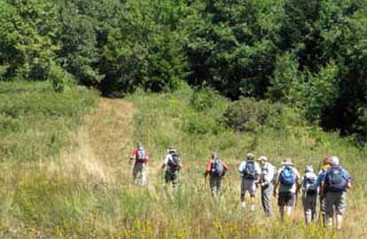
P400 From Reinhart Gap, we’ll drop down to the MST and follow it north to Haywood Gap. Possible blueberry sightings. Second meeting place: contact leader Topo: Sam Knob; also MST Profiles book, pg. 28-29
Photos by Danny Bernstein
It was a wonderful day for a hike, and our group of ten had an interesting one. The hike began with a cross-country journey from Reinhart Gap down to the MST. Happily, the cross-country leg was not too difficult, except for the blowdown underfoot. We followed the MST to Wet Camp Gap where we enjoyed lunch and the view. Then we took the MST to our cars at Buckeye Gap. The only disappointing thing for all of us was that the blueberries are gone. One hiker had another disappointment; a dead car battery. With his jumper cables and far more advice than he needed that problem was taken care of.--Dave Wetmore
--Back to Top
Half Day Sunday
HALF-DAY NO. H1003-437 Aug. 29
Pilot Cove Loop *12:30 PM
Hike 3.5, Drive 80, 1000 ft. ascent, Rated C-B
Nonmembers, call leader, Lee Belknap, 828-698-9394, rivergypsy@sprintmail.com
P400 Form carpools at Westgate, and meet leader at North Mills River Rec. Area parking lot at 1:05 PM. This (shortened version of CMC Hike #437) is a moderate hike up to the top of the cliffs on Fork Ridge, which provides beautiful views of Pilot Cove, Pilot Rock, Pink Beds, and beyond.
HALF-DAY NO. H1003-222 Sept. 5
Montreat Loop #3 *1:00 PM
Hike 5, Drive 40, 1300 ft. ascent, Rated C-B
Nonmembers, call leader, Renate Rikkers, 828-298-9988, rerikkers@aol.com
*Form carpools at Westgate, and meet leader at Ingles parking lot off I-40 at Exit 64 at 1:20 PM. We will ascend by the Graybeard Trail to the Old Trestle Road at Pot Cove Gap, then follow a recently cleared and opened section of the Old Trestle Road (not on most Montreat trail maps yet) to Graybeard Falls. We will return to Pot Cove Gap by a short steep section of the Graybeard Trail, and then retrace our path to the parking area. There are ten dry-foot stream crossings on rocks and/or logs.
Twenty-three hikers in high spirits enjoyed clear blue skies, low humidity, and temperatures in the mid-70s for this 4-hour ramble in Montreat. Rusty Frank, Montreat resident and trail maintainer, had agreed to join us and was a great co-leader, sharing Montreat history and stories along the way. This hike combines a steep and very rocky 2 1/2 mile uphill stretch on the Greybeard Trail with the easy railroad grade of the Trestle Trail. We sat around an old camp fire circle at Greybeard Falls for "snacks and stories" Unfortunately, the many weeks without rain had turned the usually lively falls into a trickle--but also made the many Flat Creek crossings easy! Much of the return is fairly steep and rocky, and those of us with creaky knees were glad to have our poles along. Thanks to Rusty for spending the afternoon with this boisterous group!--Renate Rikkers
--Back to Top
Wednesday
WEDNESDAY NO. W1003-151 Aug. 25
Shining Rock from Big East Fork 8:30 AM
Hike 8.5, Drive 60, 3100 ft. ascent, Rated B-AA
Jim Ariail, 828-505-0443, jimariail@yahoo.com
SB6K, P400 We’ll hike from the Big East parking lot up the steep Chestnut Ridge trail over Dog Loser and Old Butt knobs to lunch at Shining Rock (6040 ft.) with its exceptional views. We’ll return via a steep descent to and then along the North Fork of Shining Creek. Wilderness area hike, limit ten, so contact hike leader for reservation. Second meeting place: Big East Fork trailhead at 9:20 AM. Topo: Shining Rock; also NatGeo map #780
WEDNESDAY NO. W1003-629 Sept. 1
Rough Creek *8:45 AM
Hike 7.5, Drive 54, 1800 ft. ascent, Rated B-A
Ken & Carol Deal, 828-281-4530, cnkdeal@charter.net
*Only meeting place: Home Depot at Exit 44 of I-40. This is a rarely used trail in the Canton Watershed. During this loop hike, we walk uphill in the morning, largely on old roads, to a ridge line with long distance views. Shortly after we start down, we'll have lunch on rocks overlooking a lovely valley. After lunch we return downhill, crossing Rough Creek on a bridge. Parts of this trail have been overgrown at this time of year in the past, so it would be well to be prepared for that. The hike passes through shoulder-high jewelweed, Joe Pye weed, and thistles. Topo: Canton
Seventeen hikers joined us for this hike in the Canton watershed. For the first two miles we wound up the mountain on old roadbeds. When we got onto the Cherry Cove Trail much of it had shoulder-high to above-the-head flowers growing close to the trail. At the top we continued down the trail to a rock overlook for lunch, and then returned on the same trail. The second half of the loop hike which we had scheduled was not possible because of all the overgrowth. It was a beautiful day, some lovely views, and many, many flowers.--Ken& Carol Deal
WEDNESDAY NO. W1003-423 Sept. 8
Pilot Rock, Laurel Mtn, Slate Rock Creek Trails *9:00 AM
Hike 7, Drive 90, 1450 ft. ascent, Rated B-B
Stuart English, 828-883-2447, stuengo@comporium.net
P400 *Meet at Westgate to form carpools, and meet leader at Pisgah Ranger Station at 9:40 AM. We’ll hike up the Slate Rock Creek Trail, one of the gems of Pisgah Nat’l. Forest, and then a connector up to the Laurel Mtn. Trail, which we’ll follow for a while. We’ll turn downhill on the Pilot Rock Trail, stopping to enjoy the views along the way. Short car shuttle. Topo: Dunsmore Mtn.; also NatGeo map #78
Email your hike reports to Dave Wetmore. The deadline for reports is 9:00 p.m. on the Tuesdays before an eNews comes out. Reports for Wednesday hikes during the eNews publication week will appear in the following eNews--The Editor.
--Back to Top
All-day hikes submitted by Bruce Bente 692-0116, bbente@bellsouth.net . Driving distance is round-trip from Asheville. All Saturday and Sunday hikes assemble at Westgate Shopping Center near I-240 UNLESS OTHERWISE NOTED.
Half Day hikes submitted by Lucy Prim 828-693-6580 lucette32@mchsi.com.
Wednesday Hikes are submitted by Charlie Ferguson, 828-398-0213 ccf108@gmail.com and Ann Gleason, 828-859-9387,
gleason.ann@gmail.com .
The meeting place for each hike will be designated by the hike leader and appears in the hike description.
Driving mileage is round trip, based on the first designated meeting place. Meet at Westgate unless otherwise noted. |
