All Day Saturday & Sunday
SATURDAY No. A1004-427 Oct. 30
Soapstone Ridge 8:30 AM
Hike 10, 1200 ft. ascent, Drive 90, Rated A-B
Tom Sanders, 828-252-6327, tomary.avl@gmail.com
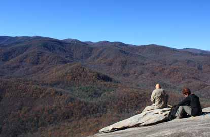
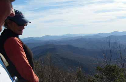
P400 We will begin at the gauging station and follow a mild bushwhack up Soapstone Ridge to the Black Mountain Trail which we’ll follow to our lunch spot at Buckhorn Gap Shelter. We’ll then take the Buckhorn Gap trail down to the S. Mills River trail and back to our cars. Second Meeting Place: Pisgah Ranger Station at 9:05 AM. Topos: Pisgah Forest, Shining Rock; also NatGeo. map #780
Though it was a beautiful day, only four of us showed up. Undoubtedly the reason was the Annual Meeting in the evening and the fact that it was a rush to finish the hike, get back to Asheville, take a shower, and get to Hendersonville. Anyway, we four really enjoyed the hike. It began at the gauging station parking lot, went down South Mills River Trail along that beautiful river. Then began the adventure! We turned off on a trail that is not on the map. It winds up Soapstone Ridge, eventually connecting with Barnett Branch, and then on up to the ridge near the Buckhorn Gap Shelter, where we had lunch. Though the hike description describes this as a partial bushwhack, the trail is in excellent condition, susprising since probably no one maintains it. After lunch we came down the Buckhorn Gap Trail and back up South Mills River Trail to our cars I am not certain this hike has been done before, but it certainly deserves to be a regular, especially in the late fall when the leaves are down and you can get good views up toward the BRP.--Tom Sanders
SUNDAY NO. A1004-709 Oct. 31
Hawksbill & Tablerock Mtns. 8:30 AM
(Bernard Elias Favorite Hikes series #8)
Hike 5, 2060 ft. ascent, Drive 140, Rated C-AA
Ted Snyder, 864-638-3686, tedsnyderjr@bellsouth.net
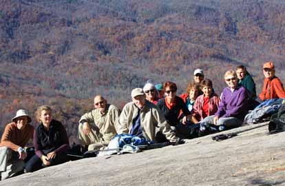
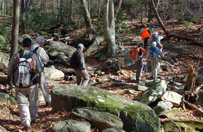
This Linville Gorge hike will consist of two steep and strenuous ascents and descents (caution!), with spectacular views from exposed rock pinnacles. We will first climb Hawksbill on the Hawksbill Trail, then descend to our cars and drive to the Spence Ridge trailhead, where we will do a loop hike up and down Tablerock Mountain on the Spence Ridge and Little Tablerock trails and the MST. Wilderness area, limit 10, so contact leader for reservation. Second meeting place, if needed: Ingles parking lot off Exit 64 of I-40 at 8:50 AM. Topo: Linville Falls; also NatGeo map #779
Due to a last minute cancellation, too late to be filled from the waiting list, the trip ran with nine participants. The weather was clear with a moderate, steady wind. Fall colors were average, although at their peak
The trip followed an innovative route, that kept us away from the crowds. The first of two hikes, to Hawksbill, began at the Sitting Bear trailhead. This connection put us on the main trail at a gap. We walked east on Sitting Bear Trail to intersect the common Hawksbill trail near the summit. We were the first visitors of the day, and had the rock to ourselves. This hike was an in-and-out of two miles.
Jim Reel ate a teaberry. He is still with us.
Retracing down from Hawksbill, we then drove about two miles, to the Spence Ridge trailhead, for our second hike. Via a connector we reached the MST and went up steeply on it to the junction for the side trip to the top of Table Rock Mountain. After lunch at the top in a sheltered spot, out of the wind, we explored the full top of Table Rock. Descending, by popular request we tramped over to the top of Little Table Rock. From that point we dropped down very steeply on Trail # 236, Little Table Rock trail, and circled west to join the Spence Ridge Trail. It led us back to our cars, which we reached at 4:00 p.m. This was a four mile loop.--Ted Snyder
SUNDAY NO. A1004-710 Nov. 7
Celo Knob from Cattail Creek *7:00 AM EST
(strenuous)
Hike 9, 2100 ft. ascent, Drive 90, Rated A-AA
Jake Blood, 828-678-0755, thebloods@hotmail.com and
John Whitehouse, 828-682-3217, johnwhitehouse@verizon.net
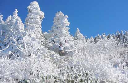
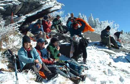
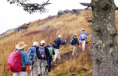
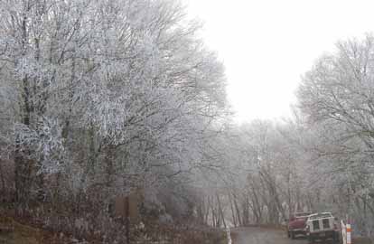
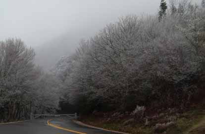
SB6K * Note change to EST today. Meet at Westgate at 7:00 AM EST (8:00 AM EDT) to form carpools, and meet leaders at the Cattail Community Center on Cattail Creek Rd. 2.2 miles from NC 197 at 8:00 AM EST. This new CMC in-and-out hike begins and ends at the cabin of one of the hike leaders on the west side of the Black Mtn. range. It first ascends from 4200 to 5700 ft. on an old logging railroad right-of-way. Lunch at the abandoned Isom mica mine with spectacular views of the Blacks and the upper Cane River valley. The hike continues up a locally known trail, “Grace’s Ladder”, to the top of Celo Knob at 6327 feet. Return to the cabin for drinks and supper (limited to 14 hikers--RSVP by e-mail to johnwhitehouse@verizon.net.) Topo: Mt. Mitchell; also NatGeo map #779
Photos by Sawako Jager and John Whitehouse
Nineteen CMC hikers set off on a cold morning with a brilliant sun and clear atmosphere. We hiked to the Isom mica mine where we took a break and enjoyed beautiful views of the Black Mountain range covered in rime ice. We then proceeded up to the old railroad grade that runs along the west side of the Blacks. We started to encounter snow underfoot. From there we hiked up "Grace's Ladder", an unmarked shortcut to the Black Mountain Crest Trail. Once on the trail above 6000 feet the snow was about two to three inches deep and the ice formed fantastic formations on the spruce and fir trees. We lunched near the junction with the Woody Ridge trail doing our best to stay out of the wind while admiring views all the way to the Smoky Mountains 80+ miles away. After lunch we ascended Celo Knob and enjoyed extraordinary views to the east of Roan Mountain, Table Rock, etc. The group returned via the same route through melting snow for a sit-down dinner at the cabin of one of the hike leaders located on Winter Star Creek.--John Whitehouse
SUNDAY NO. A1004-711 Nov. 7
Asheville MST East *9:00 AM EST
(moderate)
Hike 8.3, 1200 ft. ascent, Drive 15, Rated B-B
Marianne Newman, 828-257-2136, marianneln@att.net
This pleasant hike along the MST around the eastern end of Asheville will start at the Folk Art Center and end at US 25. Car shuttle. *Note change to EST today. Only meeting place: back parking lot of the Folk Art Center. Topos: Asheville, Oteen; also MST Trail Profiles, pg. 50 - 53
Seven hikers braved the sub-freezing, windy start of the day to enjoy a fine walk on the MST between the Folk Art Center and Hendersonville Rd. This basically gentle stretch of trail has more variety -- and more elevation gain -- than one might suspect. We delighted in the red maples' still outstanding show and also had fun playing "can you name that invasive?". --Marianne Newman
SATURDAY NO. A1004-712 Nov. 13
Purchase Knob – Hemphill Bald 10:00 AM
Hike 7.5, 1500 ft. ascent, Drive 80, Rated B-B
Kathy Skerl, 828-254-4827, kmskerl@bellsouth.net
900M This new CMC hike will begin below Purchase Knob, climb up the Ferguson Cabin Trail to the Cataloochee Divide Trail, then follow the ridgeline to Hemphill Bald. Possible visit to GSMNP Science Center. Visit a historic cabin and enjoy spectacular views. Topo: Dellwood; also NatGeo map #317
Sixteen hikers enjoyed a moderate hike in warm sunny weather up to Gooseberry Knob along the Cataloochee Divide along the southern border of GSMNP. A GPS track said it was only 5.9 miles instead of the advertised 7.5 but no one complained about the shorter distance. In the winter, the Park access road is gated, so we did a one-mile road walk before getting to Ferguson Cabin, a restored settlers cabin at 4700', and then climbing up to the Cataloochee Divide Trail and on to Gooseberry Knob with its great views. One view was of skiers below us at the Cataloochee Ski area, an oddity since it was 65 degrees. Our return went on to and down the Science Center Trail, stopping at the (closed for the winter) GSMNP Science Center. CMC plans to schedule more hikes in this interesting and scenic area in the future.--Bruce Bente
SUNDAY NO. A1004-671 Nov. 14
Raven Cliff Falls – Naturaland Trust *8:00 AM
Hike 12, 2000 ft. ascent, Drive 100, Rated A-AA
Jeff McGurk, cell: 864-921-6469, jbsbestfan@hotmail.com
*Meet at Westgate at 8:00 AM to form carpools, stop at Bi-Lo in Pisgah Forest at 8:35 AM to meet more hikers, and meet leader at Caesar’s Head S.P. Visitor Center at 9:00 AM. This new hike in Caesar’s Head State Park will go from US 276 to Raven Cliff Falls, then double back and follow the Naturaland Trust trails back to US 276 near the Visitors Center. There will be a cable crossing of Matthews Creek. Short car shuttle. Topos: Table Rock, Cleveland; also Mtn. Bridge Wilderness Area map
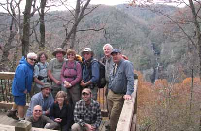
Photo by Jeff McGurk
We had 11 people in attendance for the first running of the Naturaland Trust Trail by the Carolina Mountain Club. The weather was great, the group was great, and the hike was just as advertised....some easy, some hard, and some poor footing complicated by the leaves. We agreed that the hike is about ten miles but that the elevation gain may be more in the neighborhood of 2,500 feet and the last three miles were difficult enough to earn the hike a reputation. In fact, I overheard someone mutter that this hike was going into the book. (I don't think he meant the book of pleasure hikes.) The bottom line is we all survived and enjoyed a harder than moderate workout with some nice scenery. I hope this hike becomes a somewhat regular hike with the club.--Jeff McGurk
SUNDAY NO. A1004-051 Nov. 21
Hickey Fork / Whiteoaks Flats / Pounding Mill *9:00 AM
(moderate)
Hike 8, 1900 ft. ascent, Drive 85, Rated B-A
Tish Desjardins, 828-656-2191, desraylet@aol.com
*Form carpools at Westgate, and meet leader at US25/NC208 intersection at 9:45 AM. After the hike there will be a potluck supper in the nearby Bear River Community Lodge. Hikers are requested to contribute food for the supper. Food will be taken to a refrigerator before the hike. Please phone the leader to coordinate what food to bring. We are scheduling this hike for the third time this year in the hopes that the “third time’s the charm”. .Starting at the splendid new footbridge over Hickey Fork, we’ll do a nice loop hike using three different trails and finishing on the newly and heavily rebuilt Hickey Fork Rd. Topos: White Rock, Greystone; also NatGeo map #782
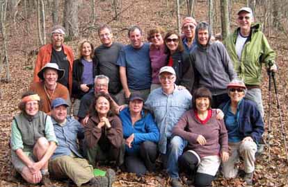
Photo by Danny Bernstein
Nineteen hikers enjoyed the Hickey Fork, Pounding Mill, and White Oak Flats trails in the Shelton Laurel Backcountry on a perfect, beautiful sunny day with sixties temperatures. With the leaves gone, the views were splendid of the peaks and valleys beyond, the rushing waters of Hickey Fork Falls, and the rhododenron and laurel-filled woods. Afterward, appetizers, a potluck supper and laughter were enjoyed around the cozy fireplace.
--Back to Top
Half Day Sunday
HALF DAY NO. H1004-349 Oct. 31
Pisgah Inn to US 276 12:30 PM
Hike 6.6 miles, Drive 50, 800 ft ascent, Rated B-C
Nonmembers, call leader, Tom Sanders, 828-252-6327, tomary.avl@gmail.com
Moderate downhill for 5 miles with views into Pink Beds area and then 800 foot ascent over 1.6 miles to US 276. Option afterwards of snacking at Pisgah Inn. Car shuttle. Second meeting place: parking area of Pisgah Inn, near convenience store, at 1:00 PM.
It was a beautiful day, and not surprisingly there were 28 of us, including former State Senator Steve Metcalf and Executive Director of Friends of the MST, Kate Dixon. The first 5 miles are a gentle, though sometimes rocky section of the MST with constant views to the South. After about 4.5 miles we had a snack. The total of this hike, 6.5 miles, is pretty long for a half-day Sunday, so we decided to give the hikers a choice, to continue on the MST, the last 1.5 miles, largely up, or take the easier 1 mile Buck Springs Trail to US276. Seven took the latter choice, and Don Walton graciously led them. Actually our main group handled the last part, with 3 uphills, pretty well. This is a really nice hike and should be done every year, though probably the max for a Halfday'er.--Tom Sanders
HALF-DAY No. H1004-035 Nov. 7
Looking Glass Rock *11:00 AM
Hike 6, Drive 70, 1800 ft. ascent, Rated B-A
Nonmembers, call leader, Kathleen Hudson, 828-698-5208 (cell: 828-329-6939), mstish1325@gmail.com
P400 *Meet at Westgate at 11:00 AM to form car pools, and meet hike leader at the Pisgah Forest Bi-Lo at 11:35 AM. A moderately difficult well-graded trail leads to the top of this mountain with beautiful views along the way. In-and-out hike.
Photos by Mike Payton
There were 14 of us that hiked to the top of Looking Glass on this brisk, clear day. The views were wonderful and there was still some color. There were two hikers visiting from New York City and one from Atlanta who were a great addition to the group. A great hike on a glorious day.--Kathleen Hudson
HALF-DAY NO. H1004-434 Nov. 14
Laurel Mountain Trail *12:30 PM
Hike 5.4, Drive 40, 950 ft ascent, Rated C-C
Nonmembers, call leader, Greg Goodman, 828-684-9703, greggoodman@bellsouth.net
P400 *Meet at Westgate at 12:30 PM to form carpools, and meet leader at the North Mills River parking area at 1:00 PM. This loop hike will start at FS 1206, go along a ridge trail toward Black Mountain, and return via the Laurel Mountain Trail. There should be good views of the Mills River Valley.
HALF-DAY NO. H1004-295 Nov. 21
Lover's Leap/Pump Gap Loop 12:30 PM
Hike 5, Drive 80, 1200 ft, ascent, Rated C-B
Nonmembers, call leader, Marcia Bromberg, 828-505-0471, mwbromberg@yahoo.com
This loop begins on the AT with a climb up to Lover's Leap where we'll stop to enjoy the view. We'll stay on the AT until the intersection with the Pump Gap Trail, which will bring us back to our starting point. Second meeting place: Roses parking lot in Weaverville at 12:50 PM
Twelve hikers took advantage of a warm and sunny fall day to enjoy the great views from Lover's Leap near Hot Springs. The views continued as we strolled along the A.T. on a ridge overlooking the French Broad River. Then we headed down to intersect with the Pump Gap Trail, continuing down to end the hike where we began on the shores of the French Broad.--Marcia Bromberg
HALF-DAY NO. H1004-707 Nov. 28
MST - Craven Gap to Haw Creek Overlook *12:30 PM
Hike 5.5, Drive 10, 700 ft. ascent, Rated C-C
Nonmembers, call leader, Jorge Munoz, 828-658-0606, jorgemunoz1927@hotmail.com
*Only meeting place: back parking lot of Folk Art Center. This is a delightful in-and-out hike along the MST from Craven Gap to Haw Creek Overlook where we shall enjoy beautiful views of the valley.
--Back to Top
All Day Wednesday
WEDNESDAY NO. W1004-250 Oct 27
Douglas Falls-Locust Ridge Circuit 8:00 AM
Hike 9, 2200 ft. ascent, Drive 60, Rated A-A
Mary Beth Gwynn, 828-545-6487, mbgcmc@gmail.com
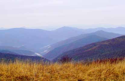
SB6K Take trail to Douglas Falls, then continue through hemlock forest to MST. Left on MST to Greybeard Overlook on BRP (good lunch stop with great view). A 1 mile round trip side hike to Craggy Dome can be done during lunch stop. Go north on MST through blueberry fields to Locust Ridge, then bushwhack down ridge to car. Topos: Montreat and Craggy Pinnacle

Photo by Mary Beth Gwyn
Seven of us braved drizzles and a threatening rain pour to hike this trail. The gravel road drive to the trailhead alone was worth the effort – 9 miles of breathtaking fall foliage, sheer rock cliffs and cascading waterfalls. Once on the trail we paused frequently take in the dramatic autumn views of the mountains. At lunch the weather turned drizzly again and we hunkered under parkas at Greybeard Overlook to eat our sandwiches and chocolate. No one was interested in bagging Craggy Dome today. A half-hour further along the trail we were rewarded with 360-degree views of sunlit mountain peaks, swirling clouds and the Asheville watershed. We then began the descent down Locust Ridge, bushwhacking for two plus miles. We never saw another person. The rain held off until we reached the shuttle car, then it really poured. --Mary Beth Gwen
WEDNESDAY NO. W1004-367 Nov. 3
Art Loeb, Grassy Ridge to Bridges Camp Gap *8:30 AM
Hike 8.5, 1650 ft. ascent, Drive 65, Rated B-A
Laura Frisbie, 828-337-5845, laurafrisbie@charter.net
P400, SB6K, WC100 *First meeting place at Ingles across from Biltmore Square Mall on NC 191.. Hike ALT to Black Balsam (6214 ft.) and Tennent Mtn. (6040 ft.), then descend to Ivestor Gap and hike down Grassy Cove Ridge to Big East Fork of Pigeon River. Two stream crossings, one or both of which will be wet, then up Bridges Camp Trail to MST and Bridges Camp Gap. Second meeting place: BRP Cold Mtn. Overlook at 9:00 AM. Car shuttle. Wilderness area hike, limit ten, so contact hike leader for reservation. Car Shuttle. Topo: Shining Rock; Nat Geo map #780
Photos by Larry Rohan
The first time I led this hike, a last minute Parkway closing forced us to change the hike. But I still hadn’t learned to check the Parkway for the 2nd try and, thanks to Jim Arial, I was notified of a closing the afternoon before the hike. It was a scramble to gather contact information and announce a new meetup and route to all the hikers (which I had only because it was a wilderness hike). We had a 50% chance of rain and it was a steady downpour on the Parkway as we drove up the gorgeous blanket of leaves along 151. We arrived to overcast but dry skies and hiked with nary a drop. In the future, I will aim for less rocky and steep trails during the wet leaf season. We had a great time, it is a wonderful hike in any weather and season. We were the only souls in sight.--Laura Frisbie
WEDNESDAY NO. W1004-213 Nov 10
Pinnacle, Rocky Knob and Graybeard from BRP *8:30 AM
Hike 6, 2000 ft. ascent, Drive 65, Rated B-A
Lee Silver, 828 668-7147 (cell: 828 442-6549), mhsrunning@yahoo.com
*First meeting place: back parking lot of Folk Art Center. Great views and side trip to Walker’s Knob a possible addition. Second meeting place: Craven Gap at 8:45 AM. Topos: Mt Mitchell and Montreat
Photos by Lee Silver and Ted Connors
A group of 8 met at the Folk Art Center and immediately starting changing plans. The Parkway was closed for road repairs and we could not reach the trail head for the Pinnacle/Rocky Knob/Graybeard hike from the south. We had to go to plan B which meant driving to Montreat and approaching Graybeard from that side. We left from the Graybeard trail head at 9:15 and climbed up the relocated Graybeard trail arriving at the peak of Graybeard for lunch.We enjoyed panoramic views while eating. The weather was absolutely perfect and the loss of leaves and clear skies made for great views throughout the hike.
After lunch we returned back down Graybeard trail taking side trips to Walker's Knob and Graybeard Falls. The views of Montreat , the Black Mountain area and the ridge lines were beautiful from Walker's Knob. Graybeard Falls had little water but was interesting and allowed us to see the old Graybeard trail. The Trestle Road affording more good views,
The hike was 8.2 miles with 2300 feet of climb. Thanks to everyone for being willing to adjust to the circumstances.--Lee Silver
WEDNESDAY NO. W1004-008 Nov 17
Bee Tree Gap to Ox Creek Rd 8:30 AM
Hike 7.9, 1500 ft. ascent, Drive 30, Rated B-B
Joe Burchfield, 828-298-8413, Burchfield@niu.edu
A moderate hike on the MST over Lane Pinnacle and past the Rattlesnake Lodge site. There are several steep but short ups and downs and a long descent. Car shuttle. Second meeting place: Craven Gap at 8:45 AM. Topo: Craggy Pinnacle; also new MST Profiles, Pg. 58-59
Photos by Lee Silver
Surprisingly, twelve hikers gathered for the third scheduled hike over Lane Pinnacle this quarter. As we stood in the cold wind on Craven Gap, the group collectively decided to shorten the hike and end it at Tanbark Ridge Tunnel. As we approached the trail head at Bee Tree Gap, rime ice covered all of the visible peaks, and we began our hike walking through a tunnel of ice. A north wind struck us at every gap and we found rime ice in every shady area for the first hour, but by the time we reached the Pinnacle, bright sun and a clear sky made for stunning winter views. At lunch we sheltered from the wind under the rocks at the top of Rich Knob, and then began the long descent to the cars. It was a good day.--Joe Burchfield
WEDNESDAY NO. W1004-627 Nov 17
Montreat Ridges and Greybeard *8:30 AM
Hike 9.5, 3200 ft, ascent, Drive 30, Rated A-AA
Ames Tryon, 828-669-3805 (cell: 828-335-6044), tryonaf@charter.net
*Form carpools at Westgate, and meet leader at Ingles parking lot off Exit 64 of I-40 at 8:50 AM. From Big Piney parking area on Greybeard, ascend to the East Ridge Trail via Rocky Head and follow old Trestle Rd to Greybeard and descend to Montreat via the West Ridge and Big Piney Trail. Great views! Topo: Montreat; also Montreat Trail Map
WEDNESDAY NO. W1004-295 Nov 24
Pump Gap Loop 9:00AM
Hike 7, 1500 ft ascent, Drive 80, Rated B-B
Stuart English, 828-883-2447, stuengo@comporium.net
From Silvermine parking area, we will ascend to the AT, go to Lover’s Leap and return down to French Broad River, Hot Springs and our cars. Topo: Hot Springs, also NatGeo map #782
Email your hike reports to Dave Wetmore. The deadline for reports is 9:00 p.m. on the Tuesdays before an eNews comes out. Reports for Wednesday hikes during the eNews publication week will appear in the following eNews--The Editor.
--Back to Top
All-day hikes submitted by Bruce Bente 692-0116, bbente@bellsouth.net . Driving distance is round-trip from Asheville. All Saturday and Sunday hikes assemble at Westgate Shopping Center near I-240 UNLESS OTHERWISE NOTED.
Half Day hikes submitted by Lucy Prim 828-693-6580 lucette32@mchsi.com.
Wednesday Hikes are submitted by Charlie Ferguson, 828-398-0213 ccf108@gmail.com and Ann Gleason, 828-859-9387,
gleason.ann@gmail.com .
The meeting place for each hike will be designated by the hike leader and appears in the hike description.
Driving mileage is round trip, based on the first designated meeting place. Meet at Westgate unless otherwise noted. |
