All Day Saturday & Sunday
NEW YEARS DAY NO. A1101-281 Jan. 1
Green River Gamelands *8:00 AM breakfast, 9:15 AM hike
Hike 6.5 or 8, Drive 70, 1300 or 1500 ft. ascent, Rated B-B
Bruce Bente, 828-692-0116 (cell: 828-699-6296), bbente@bellsouth.net
*Form carpools at Westgate (it takes 30 minutes to drive to Cracker Barrel), and meet leader at times above at the Cracker Barrel in Hendersonville (Exit 53 on I-26). Park at the NE corner of the parking lot. After breakfast, we’ll do our traditional New Year’s Day hike on a series of trails around the Green River Gamelands. We’ll hike down to and along the Green River, with a late lunch at the big rocks on the Green River, and then hike up and out on the Pulliam Creek trail. Short car shuttle. Topo: Cliffield Mtn.; also Map of the Green River Gamelands Trails
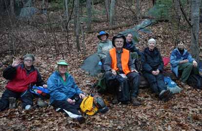
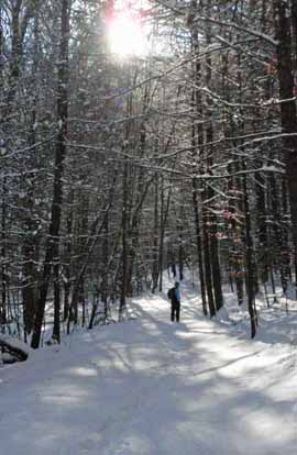
Photo by Sawako Jager
In spite of a dire weather forecast, 8 hikers (7 members plus one new hiker who saw the hike listed in the Asheville Citizen-Times) met at Cracker Barrel for breakfast to welcome in the new year. Since it was not raining when we finished eating, we decided to do the scheduled hike. Conditions were not bad for the first 3/4 of the hike...cloudy with occasional showers and temperature around 50. Views of the Green River were good and the water was higher than usual. We skipped the hike down to the big rocks on the river and our lunch stop fortunately was dry, but a steady rain began soon afterwards and continued for the rest of the hike.--Bruce Bente
SUNDAY NO. A1101-305 Jan. 2
Dupont Forest Lake Imaging P.L. #1 9:00 AM
Hike 12, Drive 82, 2300 ft. ascent, Rated A-AA
Jay Bretz, 828-658-1220, williambretz1220@gmail.com.
This low-altitude hike will traverse a loop on the northern side of Dupont Forest, from Lake Imaging to Stone Mtn., including Grassy Falls, the Thomas Cemetery and Wintergreen Falls. Second meeting place: Pisgah Forest Bi-Lo at 9:30 AM. Topo: Standingstone Mtn.
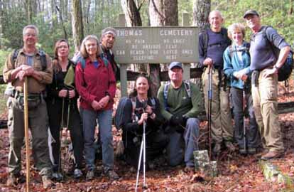
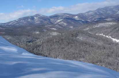
Photo by Danny Bernstein
Ten avid hikers with the resolution to start the New Year with exercise and post Holidays waist loss program embarked on a 12 mile hike in Dupont Forest on a relatively warm(40 degree) and foggy morning. To our surprise, the sun appeared about an hour later and warmed up the day to just over 50 degrees before cooling down again at the end of the hike. With the last few days of warm weather and rain, the trails were clear of snow. We checked out Grassy Creek Falls which were beatuiful. We stopped for lunch at Wintergreen Falls and bathed in the sun but not the water. After lunch we climbed gradually to Stone Mountain for beautiful long distance views of the Parkway, Mt Pisgah and the Biltmore House. We finished our hike at 4:30, just as the cold front was lowering the temperatures back into the 30's. Everyone agreed it was a wonderful day and a great way to start the New Year.--Jay Bretz
SUNDAY NO. A1101-001 Jan. 9
Case Camp – Seniard Ridge Loop 8:30 AM
Hike 8, Drive 80, 2000 ft. ascent, Rated B-A
Mary Beth Gwynn, 828-545-6487, mbgcmc@gmail.com
P400, WC100 This loop hike is scheduled for our coldest month to see 50-ft. frozen cascades along the closed BRP. We’ll do a two-mile climb up to the MST and some gentle MST hiking before our lunch spot with great views of the mountains. After lunch, we’ll hike downhill through beautiful woods on the Seniard Ridge trail. Second meeting place: Pisgah Forest Bi-Lo at 9:00 AM. Topo: Shining Rock; also pg. 36-39 of MST Trail Profiles book and NatGeo. map #780
Cancelled due to road closure.
SATURDAY NO. A1101-330 Jan. 15
Raven Cliff Falls 10:00 AM
Hike 7.5, Drive 95, 1450 ft. ascent, Rated B-B
Kathleen Hudson, 828-698-5208 (cell: 828-329-6939), mstish1325@gmail.com
WC100 *Form carpools at Westgate, and meet leader at Bi-Lo in Pisgah Forest at 10:30 AM. . Call leader if you plan on meeting at Westgate. We’ll do a pleasant walk to the pedestrian bridge over the top of a beautiful 250 ft. waterfall in Caesar’s Head St. Park in S.C. The hike will follow the Raven Cliff Falls Trail and a portion of the Foothills Trail to the bridge, and return on the same trails. Topo: Table Rock; also Mountain Bridge Wilderness Area trail map
Photos by Danny Bernstein and Bruce Bente
The hike yesterday had to be changed since Caesar's Head Park was closed. The parking lots weren't plowed and they did not want anyone on the trails.
The hike we did was # 702 in Dupont State Forest. Seven of us hiked on some cleared roads and many trails where we were the first footprints. This made the hike a bit more of a challenge. Snow shoes would have been helpful on some of the terrain. The day was gloriously beautiful.--Kathleen Hudson
SUNDAY NO. A1101-634 Jan. 16
High Top Tower Site 8:00 AM
Hike 10, Drive 65, 1900 ft. ascent, Rated A-A
Charlie Ferguson, 828-625-2677 (cell: 828-778-2431), ccf108@gmail.com
P400 This hike was a longtime favorite of the scouts at Camp Daniel Boone years ago. From the camp we will ascend to High Top with its excellent views, and then follow the Fork Mtn. ridge before descending to the rushing Little East Fork of the Pigeon River. Car shuttle. Wilderness area hike, limit ten; contact leader for reservation. Topo: Shining Rock; also NatGeo. map #780
Nine of of us had a great hike in the snow up to and along the Fork
Mountain ridgeline. The snow averaged about five or six inches deep,
sometimes up to 10 inches. With about 2,500 feet of climbing, the snow
made it feel like 4,000 feet. We hiked up a very nice unnamed
trail starting near Cathey Cove. Once we got to the top at Birdstand
Mountain there was a lot of snow which obscurred the already hard to see
trail. We wandered back an forth across the trail for some distance
until the trail became wider and on flatter ground. Along the ridge
line and up to High Top there were numerous views of the surrounding
mountains of the Shining Rock and Middle Prong wilderness. The weather
was perfect. Some hiked without jackets. After the hike most of us had dinner at the Asheville Brewing Company which warmed us up delightfully.--Charlie Ferguson
SUNDAY NO. A1101-186 Jan. 23
Little Pisgah Mountain 9:00 AM
Hike 10, Drive 36, 1500 ft. ascent, Rated A-B
Janet Martin, cell: 502-494-9309, jaykaymartin@msn.com
A pleasant nearby hike for the shorter winter daylight hours. We’ll hike from US 74A through the Florence Preserve and up into an open meadow to the summit of Little Pisgah Mtn. If the weather is clear, the view doesn’t get any better. The leader invites hikers to her home for hot soup after the hike. Topo: Bat Cave
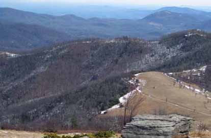
Photo by Danny Bernstein
Sunday's weather was ideal for a trek to the top of Little Pisgah. Fourteen hikers meandered under a sunny sky without any mud or ice underfoot. It was pretty chilly on the summit with a temp of 25 and a steady wind, so the wimpy leader cut the lunch break short. As the hiking was great, everyone agreed to adding an extra loop on the red trail after lunch.--Janet Martin
--Back to Top
Half Day Sunday
HIKE CANCELLED – no hike leader available Jan. 2
HALF-DAY NO. H1101-295 Jan. 9
Tanyard Gap/Pump Gap Loop 12:30 PM
Hike 5, Drive 66, 1200 ft. ascent, Rated C-B
Nonmembers, call leader: Tom Sanders, 828-252-6327, tomary.avl@gmail.com
Hike the AT from Tanyard Gap, then the whole Pump Gap Loop and back via AT.
HALF-DAY NO. H1101-320 Jan. 16
Swannanoa River Stroll to Old Farm School Rd. *12:30 PM
Hike 5, Drive 12, 100 ft. ascent, Rated C-C
Nonmembers, call leader: Bobbi Powers, 828-667-5419, bobbipowers@live.com
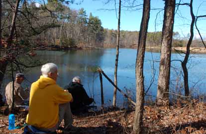
*First meeting place: Folk Art Center back parking lot. This in-out-hike begins at Owen Park and follows the Swannanoa River to Old Farm School Road, returning to the park. We will see the Warren Wilson College farm, a stand of giant bamboo, and enjoy the scenic river. Second meeting place: Charles D. Owen Park at 12:50 PM. Topo: Oteen; also Warren Wilson College Trails Map
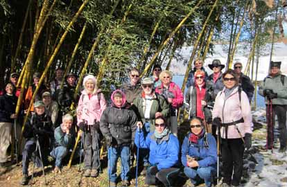
Photo by Bobbi Powers
Twenty-four cabin-fever-crazed hikers enjoyed a springlike stroll along the Swannanoa River. Trail conditions varied from hard-packed snow to slush to chocolate pudding-like mud. The river was like a picture post card with snow and ice-covered rocks. We enjoyed the sunshine while snacking at a rocky outcropping at river’s edge. Special thanks to Gale O’Neal, who, at mile 4.5, led about half the hikers on an interesting spur trail up, over, and through another area of the college which includes a pine forest. The rest of us continued on the river trail.--Bobbi Powers
HALF-DAY NO. H1101-172 Jan. 23
John Rock Loop 12:30 PM
Hike 5.7, Drive 73, 1300 ft. ascent, Rated C-B
Nonmembers, call leader: Lee Belknap, 828-698-9394, rivergypsy@sprintmail.com
P400 This moderate loop hike, with good views from the top, starts at the Fish Hatchery parking lot. Second meeting place: Fish Hatchery parking lot, off FS 475, at 1:15 PM.
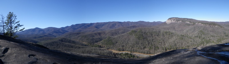
Photo by Lee Belknap
Seven of us hiked this popular loop trail counter clockwise on a beautiful partly sunny, 40 degree day. The first few hundred yards of the trail were very icy and we stopped at the edge of the parking lot to allow some hikers to put on their traction devices. Three of us completed the hike with naked soles. With the exception of the beginning and the last quarter miles, the trail conditions were mostly good with occasional ice patches with good places to step. The major exception was John Rock itself which was totally covered with ice and snow. We snacked at the access trail where we could stay safe. Unfortunately one apple wasn’t so lucky as it went rolling away from us and out of sight. The views of Looking Glass Rock and the Balsams were as spectacular as ever as were the earlier views of Cedar Rock through the bare trees.--Lee Belknap
--Back to Top
All Day Wednesday
New Wednesday Hikes--The MST Series
Barth Brooker, the president of the CMC, will be leading a series of relaxed pace, medium length hikes of the MST on Wednesdays. The series will cover most of the MST which the CMC is responsible for maintaining - from Mount Mitchell to Balsam Gap near Waynesville. It is expected that it will take a number of months to complete the series. There will be a pause in the winter while the Blue Ridge Parkway is closed. The meeting place for each hike will be at the Folk Art Center - milepost 382 on the Parkway at 10:00 AM. Meeting at the trailhead for each hike may be possible. The distance covered will be of easy to medium difficulty. The pace will be relaxed so the hikes will end anywhere from 2:00 - 3:30. Most hikes will involve a short car shuttle. These hikes will not be announced in the Let's Go newsletter so check the Wednesday hike schedule on the Web site for updates. Great for those who want a short relaxed hike or would like to see what hiking is like. Hikes will be added on each Wednesday as they are developed and experience with the first ones are evaluated.
WEDNESDAY NO. W1004-268 Dec 29
Hospital Rock to Pretty Place and Rainbow Falls *8:30 AM
Hike 8, 2000 ft. ascent, Drive 95, Rated B-A
Ann Gleason , 828-859-9387 (cell: 252-412-8132), gleason.ann @gmail.com
*Form carpools at Westgate, and meet leader at Cracker Barrel parking lot (near road) at 9:00 AM. This strenuous loop hike in Jones Gap State Park takes us up to Hospital Rock and on up to the great view (and favorite wedding site) at Pretty Place for lunch. Then hike down rocky, steep trail to Rainbow Falls. Note: $2 charge per person in Jones Gap State Park. Topo: Standingstone Mtn.; also Mountain Bridge Wilderness Area trail map
WEDNESDAY NO. W1101-305 Jan. 5
Dupont Forest North Loop 8:30 AM
Hike 12, Drive 82, 2000 ft. ascent, Rated A-AA
Jay Bretz, 828-658-1220, jbretz1220@gmail.com
This low-altitude hike will traverse a loop on the northern side of Dupont Forest, from Lake Imaging to Stone Mtn., including Grassy Falls, the Thomas Cemetery and Wintergreen Falls. Second meeting place: Pisgah Forest Bi-Lo at 9:05 AM. Topo: Standingstone Mt.
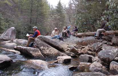
Photo by Ted Connors
Eleven hikers showed up for a winter hike on a day with a forecast of a wintry mix arriving in the afternoon. We were very fortunate and finished the hike before the rain. Temperatures reached 40 degrees as we covered 12 miles in Dupont Forest. We enjoyed beautiful Grassy Creek and Wintergreen Falls and still had a great views from Stone Mountain. No injuries happened to our group. Everyone agreed it was a good hike and not so difficult even though we hiked 12 miles. Thanks were given to me the hike leader for finishing the hike before the wintry mix.--Jay Bretz
WEDNESDAY NO. W1101-001 Jan. 12
Case Camp – Seniard Ridge Loop 8:30 AM
Hike 8, Drive 80, 2000 ft. ascent, Rated B-A
Mary Beth Gwynn, 828-545-6487, mbgcmc@gmail.com
P400 This loop hike is scheduled for our coldest month to see 50-ft. frozen cascades along the closed BRP. We’ll do a 2 mile climb up to the MST and some gentle MST hiking before our lunch spot with great views of the mountains. After lunch, we’ll hike downhill through beautiful woods on the Seniard Ridge trail. Second meeting place: Pisgah Forest Bi-Lo at 9:05 AM. Topo: Shining Rock; also pg. 36-39 of MST Trail Profiles book and NatGeo. map #780
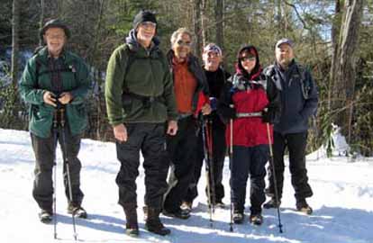
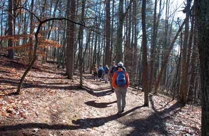
Photos by Bruce Bente
Notes: Pilot Mountain on the left, Sassafrass Knob just right of it. The following hike replaced the Seniard Ridge hike.--Editor
The following hike replaced the Seniard Ridge hike.
Bruce Bente, Paul Thrailkill and I set out for John Rock Loop at 9:45 am and returned at 2 pm. The day was bright blue and sunny and there was virtually no wind, despite contrary weather reports. Hiking through the woods was beautiful. We carefully skirted the edge of John Rock, with its extraordinary views, because of the ice sheet on bald rock below the snow (see photo). The most dangerous part of the day, by far, was the drive out of Pisgah Forest in the afternoon. Icy roads had the car sliding and skidding. The day was a perfect antidote for cabin fever!--Mary Beth Gwin
WEDNESDAY NO. W1101-550 Jan. 19
Paris Mountain State Park *8:00 AM
Hike 9.9, Drive 130, 2000 ft. ascent, Rated A-A
Kathleen Hudson, 828-698-5208 (Cell: 828-329-6939), mstish1325@gmail.com
*Form carpools at Westgate, and meet leader at NE corner of Cracker Barrel parking lot at exit 53 of I-26 at 8:30 AM. Call leader if you plan on meeting at Westgate. Located between Traveler’s Rest and Greenville, Paris Mountain State Park is one of the oldest protected areas in South Carolina. Originally, the lakes were the source of Greenville’s water supply. We will walk on well-maintained trails, enjoying good views of Greenville. $2 per person entrance fee. Topo: Paris Mtn.
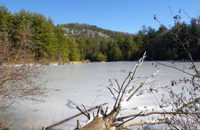
Photos by Ted Connors
Seven of us spent a fun 5 hours on a clear, sunny day on the Paris Mountain hike. There were views in every direction on the way up to North Lake, a nice lunch stop by the lake and an interesting downhill by the dam and stone tower which used to house the mechanics to control the flow of the water. It was really a beautiful hike and everyone needs to put it on their calendar the next time it is offered.
I took a bit of a detour by taking the wrong branch of a trail which lead us around in a circle but it added some extra laughs and about an extra mile to the hike.--Kathleen Hudson
WEDNESDAY NO. W1101-186 Jan. 26
Little Pisgah Mountain *9:00 AM
Hike 10, Drive 30, 1500 ft. ascent, Rated B-B
Keiko Merl, 828-628-2396
*Only meeting place: Folk Art Center back parking lot A pleasant hike, close to home for our coldest month. We’ll hike from US 74A through part of the Florence Preserve and up into an open meadow to the summit of Little Pisgah Mtn. If the weather is clear, the view doesn’t get any better. Topo: Bat Cave
Email your hike reports to Dave Wetmore. The deadline for reports is 9:00 p.m. on the Tuesdays before an eNews comes out. Reports for Wednesday hikes during the eNews publication week will appear in the following eNews--The Editor.
--Back to Top
All-day hikes submitted by Bruce Bente 692-0116, bbente@bellsouth.net . Driving distance is round-trip from Asheville. All Saturday and Sunday hikes assemble at Westgate Shopping Center near I-240 UNLESS OTHERWISE NOTED.
Half Day hikes submitted by Lucy Prim 828-693-6580 lucette32@mchsi.com.
Wednesday Hikes are submitted by Charlie Ferguson, 828-398-0213 ccf108@gmail.com and Ann Gleason, 828-859-9387,
gleason.ann@gmail.com .
The meeting place for each hike will be designated by the hike leader and appears in the hike description.
Driving mileage is round trip, based on the first designated meeting place. Meet at Westgate unless otherwise noted. |
