All Day Saturday & Sunday
SATURDAY NO. A1101-268 Jan. 29
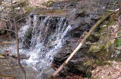
Hospital Rock – Rainbow Falls *8:30 AM
Hike 8, Drive 95, 2000 ft. ascent, Rated B-A
Brenda Worley, 828-684-8656 (cell: 828-280-2564), clworley@bellsouth.net
WC100 *Form carpools at Westgate, and meet leader at Cracker Barrel at Exit 53 of I-26 at 9:00 AM. This is a challenging hike in Jones Gap State Park in S.C. Hiking up past Hospital Rock, we will enjoy a great view at lunchtime from Pretty Place. After lunch we will walk along a road for a short distance, then turn downhill past beautiful Rainbow Falls onto a trail down to the river and back to our cars. NOTE: $2/person parking fee at trailhead. Topos: Cleveland, Standingstone Mtn.; also Mountain Bridge Wilderness map

Photo by Brenda Worley
Nine very capable hikers showed up and met the challenge of the extreme terraine of this hike. We got on the trail at 9:45 am and were off the trail at 3:35 pm. We were treated to great weather which added to the beauty of the waterfalls and scenery. It was a great day for a great hike.--Brenda Worley
SUNDAY NO. A1101-141 Jan. 30
Rock Jock Loop – Linville Gorge (strenuous) 8:00 AM
Hike 9, Drive 120, 2500 ft. ascent, Rated A-AA
Jacob Cox, 828-584-0395, jcox@mfgnc@com
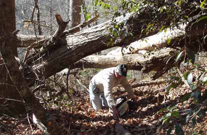
*Form carpools at Westgate, and meet leader at Deal Barn at Exit 90 of I-40 at 8:45 AM Very technical hike. Begin with a steep descent into Linville Gorge via Pinch-In Trail. Hike upstream beside the Linville River to Conley Cove Trail, and return along western rim via Rock Jock Trail. Rock Jock is very difficult terrain, seldom used, and provides spectacular views. Short car shuttle. An alternate hike will be arranged if conditions are snowy or icy. Wilderness area hike limited to ten people; please contact leader for reservations. Topo: Ashford; also NatGeo map #779
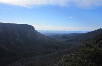
Photo by Don Walton
Nine hikers (many in shorts and short sleeved shirts) enjoyed 60 degree weather and sunshine, while trekking through strenuous trails of the Linville Gorge. Rather than waiting at the trailhead for the car shuttle to be set up, two hikers (who had been on the scout hike) were kind enough to lead the group to the best rock outcropping on the Pinch-In Trail. They basked in the morning sun with a spectacular view of the South end of Linville Gorge, as the hike leader and drivers caught up. The group proceeded to hike across extremely difficult terrain on a gorgeous day, averaging close to 1 mph throughout much of the hike. Around the 7 mile mark, we reached the "decision point" on Rock Jock Trail, enjoying a cliff overlook peering directly across the Gorge at Table Rock. Six hikers decided to enjoy the cliff overlook for an extended period, backtrack to a vehicle waiting at Conley Cove, and finish a shortened version of the hike totaling about 8 miles. They enjoyed refreshing beverages and watched the last rays of sunlight reflect off Shortoff Mountain, while waiting for the remaining 3 hikers to complete the last few difficult miles of Rock Jock.--Jacob Cox
SUNDAY NO. A1101-137 Feb. 6
Roans in Snow 8:00 AM
(strenuous)
Hike 7 or 12, Drive 150, 1000 or 1900 ft. ascent, Rated B-B or A-A
Lisa Hart, 828-450-6986, tiw.south@gmail.com and Jim Reel
SB6K The leader intends to lead a snowshoe hike. The Roans experience heavy snow, and snowshoes or traction devices will be required if snow/ice is present. Please email the leader in advance to check conditions. If snow/ice are present or forecast, leader approval is required to join the hike. From Carver’s Gap we’ll go north past Grassy Ridge (6160 ft.) to a scenic overlook for lunch, then return to Carvers Gap. Optional side hike up to Roan High Knob (6285 ft.) and Roan High Bluff (6267 ft.), with return on either the road or the AT. Topo: Carvers Gap; also NatGeo. map #783
SUNDAY NO. A1101-636 Feb. 6
Coontree-Bennett Gap-Pressley Cove Lollipop 9:00 AM
(moderate)
Hike 8.4, Drive 75, 1900 ft. ascent, Rated B-A
Bob Hysko, cell: 828-243-3630, rhysko@yahoo.com
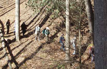
P400 This hike is an extension of the popular half-day Coontree Loop hike. We ascend the left branch of Coontree trail, proceed in and out on Bennett Gap and Pressley Cove trails and descend on the right branch of Coontree trail to the cars. We will visit an old homestead chimney, a remnant of the farming community between Pressley Cove and Maxwell Cove. Topo: Pisgah Forest; also NatGeo. map #780
On a beautiful sunny, 55 degree day, 15 people enjoyed a pleasant hike in Pisgah National Forest. When we visited an old homestead chimney, Paul Thraikill, explained proper chimney design and showed us how this old chimney was designed for maximum efficiency compared to many modern chimneys which are built for maximum draw. Special thanks to Ashok and Janet Martin for helping me scout this hike.--Bob Hysko
SATURDAY NO. A1101-256 Feb. 12
Moore Cove Figure-8 Loop *10:00 AM
Hike 7, Drive 70, 1000 ft. ascent, Rated B-B
Jan Onan, cell: 828-606-5188, janonan@bellsouth.net
P400 *Form carpools at Westgate, and meet leader at Pisgah Forest Bi-Lo at 10:35 AM. This moderate double-loop trail follows two old USFS paths. There are a couple of short steep sections and two minor creek crossings. There is one good view of Looking Glass Rock, several waterfalls, and other views visible only in the winter. Topo: Shining Rock; also NatGeo. map #780
Photos by Jan Onan
February 12th was a beautiful calm and sunny day and brought out 20 hikers for a respite from cabin fever. We formed carpools at the 2nd meeting place and were on the trail by 11:10. We welcomed three new hikers to CMC! We warmed up by walking to Moore Cove Falls first. Then it was a climb to the top! This hike offers a good cardio workout as most of the climbing is in the first half of the hike. Once at the top, we can really say “it is all downhill from here”! We did experience some downed trees and muddy creek crossings, but nothing impassable. It was a delightful group and a delightful day. I want to thank Tom for being my ever trusted sweep and for Joan for being so willing to change her plans to encourage one of our new hikers. We finished at 3:30. The day flew by.--Jan Onan
SUNDAY NO. A1101-535 Feb. 13
Indian Creek – Sunkota Ridge loop *7:30 AM
Hike 12, Drive 135, 2000 ft. ascent, Rated A-A
Mike Knies, 828-628-6712, knies06@att.net
900M, WC100 *Note early start time. We’ll make a loop using Indian Creek and Martin’s Gap trails, then down Sunkota Ridge and Deep Creek Trails, admiring three waterfalls and winter views of Noland and Thomas Divides. Second meeting place: US 23/74 rest area past Waynesville at 8:00 AM. Topos: Bryson City, Clingman’s Dome; also Nat Geo. Map #317
SUNDAY NO. A1101-276 Feb. 20
Street Gap to Big Bald 8:30 AM
Hike 10, Drive 80, 2300 ft. ascent, Rated B-A
Paul Benson, 828-251-1909, pdbenson@charter.net
The leader intends to lead a snowshoe hike. This ridgeline experiences heavy snow, and snowshoes or traction devices will be required if snow/ice is present. Please e-mail the leader in advance to check conditions. If snow/ice are present or forecast, leader approval is required to join the hike. This is an in-and-out hike on the Appalachian Trail, heading north. Depending on whether the access road is drivable, mileage and ascent may vary. We will have panoramic views of the Blacks, Smokies and other ranges in WNC and TN from the higher elevations. Topos: Sams Gap, Bald Creek
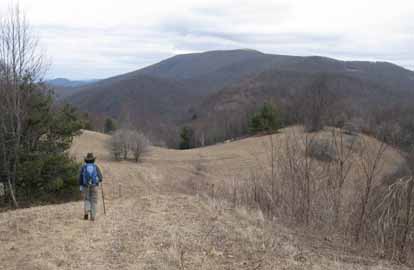 
Photos by Paul Benson
This was advertised as a possible snowshoe hike (there was about 2' of snow up there this time last year) but only patches of slushy snow remained in north facing pockets. However, instead of the sunny spring-like conditions we've been enjoying in Ashevillle, it was windy, cloudy, and cold for most of the hike. Because muddy road conditions prevented two-wheel drive vehicles from driving up to Street Gap, we started at Sams Gap which increased the length of the hike from 8 miles to 13 miles. Most of the hike was through very scenic open mature hardwood forest, just below the top of the ridge. After tagging the summit of Big Bald, enjoying panaromic views and enduring windchills in the teens, lunch was a rather quick affair in the shelter of a rock outcropping just below the bald. The return hike was at a slightly more leisurely pace due to a little more warmth from hazy sunshine. Back at the cars most of us enjoyed refreshments, including home-made oatmeal raisin cookies furnished by my lovely wife.--Paul Benson
--Back to Top
Half Day Sunday
HALF-DAY NO. H1101-623 Jan. 30
Old Fort to Kitsuma Peak 12:00 PM
Hike 6, Drive 60, 1800 ft. ascent, Rated C-A
Nonmembers, call leader: Renate Rikkers, 828-298-9988, rerikkers@aol.com
This popular but somewhat strenuous hike begins near Old Fort and ascends Young's Ridge to Kitsuma Peak, overlooking and continuing on to Ridgecrest. Outstanding views along the way. Car shuttle. Second meeting place: Ingles parking lot at Exit 64 of I-40 at 12:20 PM.

Photo by Bobbi Powers
Beautiful sunshine, blue sky, and the amazing 60-degree temperature put 12 happy hikers in the best of spirits for the steady climb from Old Fort to Ridgecrest on the Young's Ridge Trail. The trail had dried up very well after the most recent snow storms, and we encountered no ice along the way. This hike can't be rushed because it's steadily uphill except for the last half hour. Meeting at noon was good timing since an hour is needed between leaving Westgate, car shuttling, and getting on the trail. Hike time was 4 hours and 15 minutes, getting us to Ridgecrest at 5:15 PM for car pick-up in Old Fort.
A great but demanding hike with an exceptionally compatible group of fun and interesting hikers which included a geology professor and two oceanographers who added some "lecturettes" along the way.--Renate Rikkers
HALF-DAY NO. H1101-431 Feb. 6
Chestnut Cove to MST to Sleepy Gap to Explorer Trail 12:30 PM
Hike 5, Drive 20, 900 ft. ascent, Rated C-C
Nonmembers, call leader: Joe Burchfield, 828-298-8413, burchfield@niu.edu
This loop hike begins with a moderately steep climb from the Bent Creek Gap Road to the MST, but is otherwise an easy walk. Second meeting place: Ingles parking lot across from Biltmore Square Mall on NC 191 at 12:45 P.M. Topo: Dunsmore; also USFS Bent Creek Trail Map

Photo by Bobbi Powers
HALF-DAY NO. H1101-182 Feb. 13
Green River Cove Trail *11:00 AM
Hike 5.5, Drive 73, 500 ft. ascent, Rated C-C
Nonmembers, call leader: Marcia Bromberg, 828-505-0471, c798-9905, mwbromberg@yahoo.com
*Note early start. This is a scenic winter hike along the lovely Green River. We'll begin with an early lunch/snack on the bank of the river, then hike as far as the junction with the Pulliam Creek Trail. We'll return by the same route. This hike includes a few steep, but short uphills. Second meeting place: Cracker Barrel at Exit 53 off I-26 at 11:30 AM. Topo: Cliffield Mt; also Green River Gamelands Map

Photo by Marcia Bromberg
On a perfect day that smelled like spring, 24 hikers joined this hike along the Green River. The river was green, the sky was blue and the temperature warm enough so that most people were soon down to T-shirts. After a leisurely lunch along the river we hiked the Green River Cove Trail to where it meets the Pullium Creek Trail then returned along the same path. I took special pleasure in the age range of our hikers--from 11 year-old Brooke to 81 year-old Tom. I think this exemplifies the way the CMC brings people together!--Marcia Bromberg
HALF-DAY NO. H1101-686 Feb. 20
Shope Creek Ramble 12:30 PM
Hike 5, Drive 25, 750 ft. ascent, Rated C-C
Nonmembers, call leader: Gail Lamb, 828-298-8413, galmb46@bellsouth.net
This is a short ride for a winter walk in the woods, partly along Shope Creek in the Riceville Rd. area. It has been recently opened to hikers and has some unmarked trails, some of which are near, but not connecting to the Parkway. Possible wet stream crossing. Second meeting place: Ingles across from V.A. Hospital on Rt. 70, Tunnel Rd. at 12:45 PM.
 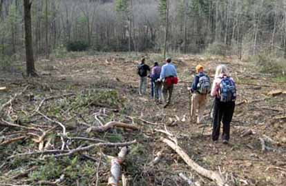
Photos by Danny Bernstein
A new hike for CMC was inaugurated by 25 hikers in the Shopes Creek area. We explored 5 miles with two loops and some beautiful views of Shopes Creek. We were fortunate to have Dr Tim Forrest, biology professor at UNCA, open the gates so we could park inside the locked area. Although this area was opened to use from Shopes Creek several years ago, parking is a problem. The Forest Service has not yet provided the planned parking area. It was a beautiful, moderately easy hike until we exited through a clear-cut section.--Gail Lamb
We named the above falls, Forrest Falls, after Tim Forrest. Ed.
--Back to Top
All Day Wednesday
New Wednesday Hikes--The MST Series
Barth Brooker, the president of the CMC, will be leading a series of relaxed pace, medium length hikes of the MST on Wednesdays. The series will cover most of the MST which the CMC is responsible for maintaining - from Mount Mitchell to Balsam Gap near Waynesville. It is expected that it will take a number of months to complete the series. There will be a pause in the winter while the Blue Ridge Parkway is closed. The meeting place for each hike will be at the Folk Art Center - milepost 382 on the Parkway at 10:00 AM. Meeting at the trailhead for each hike may be possible. The distance covered will be of easy to medium difficulty. The pace will be relaxed so the hikes will end anywhere from 2:00 - 3:30. Most hikes will involve a short car shuttle. These hikes will not be announced in the Let's Go newsletter so check the Wednesday hike schedule on the Web site for updates. Great for those who want a short relaxed hike or would like to see what hiking is like. Hikes will be added on each Wednesday as they are developed and experience with the first ones are evaluated.
WEDNESDAY NO. W1101-031 Feb. 2
South Mountains Loop 8:00 AM
Hike 9.3, Drive 170, 2300 ft. ascent, Rated A-AA
Charlie Ferguson, 828-625-2677, ccf108@gmail.com
WC100 South Mountains State Park south of Morganton has outstanding views, a beautiful waterfall, and a new visitor center. We’ll climb to Jacob Fork River Gorge Overlook and then continue to Chestnut Knob Overlook, a rocky outcropping with outstanding views toward the Kings Mountain Range and on a clear day, Charlotte’s skyline. Later after another climb, we’ll reach the top of High Shoals Waterfall – truly awesome. Awesome too is the wooden staircase and platform, which allows a close look at the falls and the jumble of rocks in Jacob Fork. Since this is a state park, the trails are meticulously maintained. Possible supper after the hike. Second meeting place: Ingles parking lot at Exit 64 of I-40 at 8:20 AM. Topo: Benn Knob; South Mountains SP map
 
Photos by Ted Connors and Charlie Ferguson
The weather was great, cool but not cold all day. Hazy sun and good views of the South Mountains. Seven of us braved the long drive. The hike was mostly through open woods. Most of the trails were very well maintained, smooth and wide enough for two to hike together. The hike started with a climb of 1,000 feet, a little steep, with two overlooks with nice views of the South Mountains, the High Shoals Falls and Charlotte hidden in the clouds. We had lunch at the edge of a meadow on top of one of the small knobs along the Horse Ridge line. After lunch there was a steep narrow 600 foot descent to Shinny Creek (pronounced shiny as in mica flakes). Then on the last third of the hike, we had a climb of 600 feet. Right after the climb there is a good view to the north of the Linville Gorge peaks and the Roan Mountains behind them. Soon we arrived at the top of High Shoals Falls, walked down the wood walkways and steps to the base of the Falls.--Charlie Ferguson
WEDNESDAY NO. W1101-236 Feb. 9
Dupont Forest- Fawn Lake & Bridal Veil Falls 8:30 AM
Hike 8, Drive 95, 1000 ft. ascent, Rated B-B
Paula Massey, 828-299-0226, massey.paula@gmail.com
WC100 A moderate hike featuring beautiful waterfalls and lakes. We'll see Corn Mill Shoals, Bridal Veil Falls, Lake Julia and Fawn Lake, hiking at an easy pace. Second meeting place: Pisgah Forest Bi-Lo at 9:05 AM. Topo: Standingstone Mtn,; also Dupont Forest trail map
 
Photos by Ted Connors
Ten lucky CMC members braved the early morning low temperatures and won . . .a beautiful walk in the Dupont Forest with views of Pisgah Mountain, lakes, and scenic dining at Bridal Veil Falls on a sunny day. And we made it home before the skies turned cloudy and it snowed!--Paula Massey
WEDNESDAY NO. W1101-374 Feb. 16
Good Road to Bald Knob 8:30 AM
Hike 9.5, Drive 90, 2500 ft. ascent, Rated A-AA
Barbara Morgan, cell: 828-460-7066, bcmorg@hughes.net
Park on Good Road in McDowell County off US 221. Hike on MST to N Fork of Catawba River, cross bridge, and ascend to top of Bald Knob. A steep hike, but spectacular winter views. Return by same route. Second meeting place: Ingles parking lot at Exit 64 of I-40 at 8:50 AM. Topo: Little Switzerland
WEDNESDAY NO. W1101-271 Feb. 23
Chestnutwood Mountain 8:00 AM
Hike 9, Drive 70, 2700 ft. ascent, Rated A-AA
Rich Sampson, 704-453-9059, sampson_r@bellsouth.net
We will do our major climbing before lunch on this pleasant hike past streams, two nice cascades, a glimpse of the Black Mtns., and a 20 yr. old timber harvest in the Grandfather District. Some bushwhacking and hiking on over-grown trails. Short car shuttle. Second meeting place: Ingles parking lot at Exit 64 of I-40 at 8:20 AM Topo: Old Fort
Email your hike reports to Dave Wetmore. The deadline for reports is 9:00 p.m. on the Tuesdays before an eNews comes out. Reports for Wednesday hikes during the eNews publication week will appear in the following eNews--The Editor.
--Back to Top
All-day hikes submitted by Bruce Bente 692-0116, bbente@bellsouth.net . Driving distance is round-trip from Asheville. All Saturday and Sunday hikes assemble at Westgate Shopping Center near I-240 UNLESS OTHERWISE NOTED.
Half Day hikes submitted by Bonnie Allen, 828-645-0357, bonnie@allencats.com
Wednesday Hikes are submitted by Charlie Ferguson, 828-398-0213 ccf108@gmail.com and Ann Gleason, 828-859-9387,
gleason.ann@gmail.com .
The meeting place for each hike will be designated by the hike leader and appears in the hike description.
Driving mileage is round trip, based on the first designated meeting place. Meet at Westgate unless otherwise noted. |
