All Day Saturday & Sunday
SUNDAY NO. A1102-xxx May 8
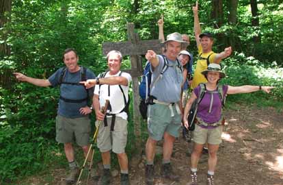
AT section hike: Iron Mountain Gap to Hughes Gap 8:00 AM
Hike 9.1, Drive 120, 2400 ft. ascent, Rated A-AA
Paul Benson, cell: 828-273-2098, pdbenson@charter.net
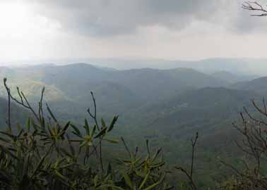
Let's join the north-bound thru-hikers on the AT if only for 9 miles. This up and down section tracks along the state line ridge with continuous good views since the leaves should only be beginning to come out, and outstanding views at Little Rock Knob. We'll plan on lunch at the Clyde Smith shelter. (Who is Clyde Smith? Come on the hike and find out!) Car shuttle. NatGeo. map #783, ATC Offical NC-TN Map #2.
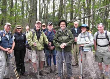 
Photos by Paul Benson
It was special to lead a hike at a time when we could share the trail with thru-hikers on their way to Maine, (and we got to talk with lots of them) and at a time when spring is just reaching it's peak. We enjoyed the last of the leaf-free views of the year at only the highest elevations we reached, and also enjoyed the lushness of rampant spring growth at the lower elevations, including a variety of beautiful spring blossoms and some tasty ramps.
As promised, the leader told all he knew about Clyde Smith while the group lingered at the shelter that bears his name. Mr. Smith died while working on the trail in 1976 near Roan Mountain and was know for the numerous trail signs that he made along the AT and other places including Grandfather Mountain. I'd like to think that we saw a couple of his original signs at the Iron Mountain Gap northbound trailhead and at the intersection leading to his namesake shelter. Fire warden, Blue Ridge Parkway Ranger, trail sign maker, trail builer - he was real mountain man and I'm sorry I never got to meet him. --Paul Benson
SATURDAY NO A1102-611 May 14
Big Ivy - Walker Ridge Loop 10:00 AM
Hike 8.2, Drive 34, 1950 ft. ascent, Rated B-A
Marcia Bromberg, 828-505-0471, mwbromberg@yahoo.com
We'll start our hike on the Walker Creek and Perkins Trails. Most of the altitude gain is accomplished during the first hour of the hike. The ascent will be at a moderate pace. Our next two miles is a stroll on the meadow-like Laurel Gap Trail, before heading back down to the cars, using the Bear Pen and Staire Creek Trails. These trails are rocky and steep in spots. There are several stream crossings on this hike. We walk near lovely creeks on part of the trails. Topo: Mt Mitchell, Craggy Pinnacle, Montreat; also South Toe/Big Ivy FS map RG355 and NatGeo map #779
With rain threatening I only had 3 "takers" for this 8+ mile hike in the Big Ivy area. Because trails were wet we decided to hike up, rather than down, the steepest trail and did the hike in the opposite direction than planned. Although we did get rain in the last few miles everyone agreed that is was a beautiful hike and well worth getting a little wet.--Marcia Bromberg
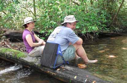
SUNDAY NO. A1102-726 May 15
Tanbark Tunnel to Folk Arts Center *9:00 AM
Hike 9.9, Drive 16, 1500 ft. ascent, Rated A-B
Kathleen Hannigan, cell: 828-230-4883, Kathleen.hannigan@pgnmail.com
*Only meeting place is back parking lot of Folk Arts Center. After a short climb up to the historic Rattlesnake Lodge site, this hike will be a generally moderate stroll on the MST through nice woodlands. After the hike, hikers are invited to join the leader for wine and cheese at her home. Car shuttle. Topo: Craggy Pinnacle
Photos byDanny Bernstein
After expecting to have to walk in the rain, we were pleasantly surprised to have a beautiful, cool day for hiking. There were many wildflowers. Sawako recorded 67 different blooms including beautiful lady slippers. There were also many flame azalea and mountain laurel in bloom. Unfortunately one of the most prolific plants we saw was lush, large poison ivy plants! I would strongly suggest wearing pants for any hikes on the MST during the coming warm season. At the conclusion of the hike we retrieved our cars from the short car shuttle, and the hikers followed the leader to her nearby home for a wine and cheese party. It was great weather so everyone really had a good time hanging out in the yard munching on snacks, sipping refreshing beverages, admiring the flowers, and even enjoying a fire in the fire pit. Too bad every hike can’t end that way!--Kathleen Hannigan
SATURDAY NO. A1102-727 May 21
Wilderness Walk-through 8:00 AM
Hike 8, Drive 77, 1000 ft. ascent, Rated B-B
Paul Dickens, 828-476-0010, psdicken@charter.net.
We’ll hike south to north through the Shining Rock Wilderness to check trail conditions and introduce CMC members to wilderness trail maintenance work and standards. This hike will do no work other than clearing minor blowdowns and collecting trash. Starting at the Black Balsam parking lot at end of FS 816 off BRP, we’ll hike Investor Gap Trail (FS 101) to Ivestor Gap, then Greasy Cove Trail (FS 362) down to Pigeon River, and out Big East Fork Trail (357) along Pigeon River to the Big East Fork parking lot. Two stream crossings may be wet crossings. Car shuttle. Wilderness area hike, limit ten; contact leader for reservation. Second meeting place: BRP Cold Mtn. Overlook at 8:40 AM. Topos: Sam Knob, Shining Rock; also NatGeo map #780
Four of us had a good hike--nice weather, slightly hazy. We changed the route somewhat, hiking over Black Balsam to Ivestor Gap and down Greasy Cove and East Fork trails. Just inside the wilderness area we met three parties which were lost. We did some light maintenance work as we hiked.--Paul Dickens
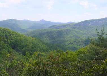
SUNDAY NO. A1102-218 May 22
Cataloochee Divide 8:00 AM
Hike 12, Drive 85, EB: 1800 ft. ascent, Rated AA-A, or WB: 2800 ft. ascent, rated AA-AA
Lisa Hart, 828-450-6986, tiw.south@gmail.com and Paul Benson, 828-251-1909, pdbenson@charter.net
900M If it is clear, we will experience some of the most spectacular views in WNC as we hike over Hemphill Bald and the Swag. Wildflowers should be wonderfully abundant. Key swap hike, with half the group starting from each end. Second meeting place: K-Mart parking lot in Waynesville at 8:30 AM, but call leader beforehand. Topos: Cove Creek Gap, Dellwood, Bunches Bald; also NatGeo. Map #316
Fifteen hikers braved this key swap. Carroll Koepplinger (who was traded up as co-leader) led 7 of the group from Polls Gap to Cove Creek Gap (EB). I led the WB group of 8. Weather was delightful and the flower experts counted over 40 different types. The highlight was the Vasey’s Trillium, which is the largest of the Trillium family with petals up to 4 inches and found only in the southern Appalachians. The petals nod below the three-leaved whorl and are deep maroon or red.
We missed our objective of the two groups meeting at Hemphill Bald for lunch and exchanged keys at Double Gap. The EB group had lunch at the Swag area and the WB group enjoyed a double-batch of double-chocolate brownies on Hemphill Bald.
Several of the hikers enjoyed dinner and companionship at Barley’s in Asheville.
SUNDAY NO. A1102-444 May 29
Avery Creek Loop *8:00 AM
Hike 10, 1700 ft. ascent, Drive 80, Rated A-A
Michael and Kathy Cornn, cell: 828-458-1281 or 828-458-1282, mcornn@aol.com
P400 *Form carpools at Westgate, and meet leader at Pisgah Forest Bi-Lo at 8:35 AM. A scenic hike featuring waterfalls and a beaver dam. We’ll first climb to Buckhorn Gap via Twin Falls, then follow the Black Mtn. Trail to Club Gap, with our return downhill on the Avery Creek Trail.. Topos: Pisgah Forest, Shining Rock; also NatGeo. map #780
Photos by Kathy Cornn
Eight hikers welcomed summer with a hike along Avery Creek to Twin Falls, Buckhorn shelter and back down Avery Creek. This was a second attempt to complete the hike. The earlier one was cut short when a right turn was made instead of a left. This time hikers saw the shelter- built by the Youth Conservation Corps in 1979. The song of the wood thrush and the sound of falling water followed us, and there was a dense tree canopy fending off the heat. We crossed paths with toads, an eastern newt, a snake, mountain bike riders and a dung beetle. The dung beetle was rolling a golf ball-sized dung ball through our lunch site. On the way back down we soaked our feet in Avery Creek. We finished the hike early and ate watermelon, and quenched our thirst at the trail head. Six of us ate at Dugan's afterward. While eating we fondly remembered Paul Benson's burger eating contest attempt at the pub earlier this year.--Kathy Cornn
MEMORIAL DAY NO. A1102-728 May 30
Chimney Tops Loop (Joint hike with SMHC) *7:45 AM
Hike 11.5, Drive 150, 2700 ft. ascent, Rated A-AA
Becky Smucker, cell: 828-231-2198, bjsmucker@gmail.com
900M *Note earlier start time. From the Chimney Tops Trailhead, we will climb 3.3 miles to the AT via the Chimney Tops and Road Prong trails, a historic route formerly part of the Oconaluftee Turnpike which was heavily used during the Civil War. Along the way we will pass a reported Indian cemetery, Beech Flats, Indian Grave Flats, several waterfalls, and a few stream crossings. After 2.5 miles along the AT, we will turn down the Sugarland Mountain trail. At 3.2 miles down this trail, we will take the unmaintained Chimneys Manway 0.4 miles over to the Chimney Tops. After enjoying the views from here, we will take the Chimney Tops Trail back to the trailhead. Second meeting place: back of Maggie Valley Post Office lot at 8:30 AM, but contact leader first. Topos: Clingmans Dome, Mt. LeConte; also NatGeo map #317
Warm, mostly clear Memorial Day weather put all 26 hikers (8 from CMC) in a great mood for this loop. It was a long but beautiful drive from Asheville, and we checked out the new and attractive Oconaluftee Visitors Center on the way. The climb up Road Prong Trail and the AT was hard work, and we were glad that water levels were down so we could rock-hop the creeks. The pace was easy enough that we could carry on converstions with our Smoky Mountain Hiking Club friends, new and old. We hit the Catawba Rhododendron bloom at the perfect stage, when flowers are newly opening and richly colored. The manway that cut through from Sugarland Mountain Trail to Chimney Tops Trail added interest and challenge, and again we were glad it wasn't raining, as it would have made that manway very difficult in the steep places. Those who chose to climb the rockface found it invigorating, and easier to descend than ascend. This joint hike is a worthwhile tradition to continue, as we can make new hiking friends, compare notes and get new ideas for hikes and club functions.--Becky Smucker
--Back to Top
Half Day Sunday
HALF-DAY NO. H1102-049 May 1
Big Creek in the Smokies 12:00 PM
Hike 6, Drive 110, 500 ft ft. ascent, Rated B-B
Nonmembers, call leader: Renate Rikkers, 828-298-9988, rerikkers@aol.com
900M, WC100 Big Creek, a spectacular mountain stream in the Smokies, offers hikers and walkers an opportunity to slow down and appreciate the wild beauty of this part of the park. The comfortable roadbed meanders along rushing rapids, a waterfall, huge boulders, and deep swimming holes. A beautiful forest and wildflower environment makes for a special experience. An easy in-and-out hike. Bring your camera! Second meeting place: Pilot Truck Stop, off I-40 at Exit 24 at 12:30 PM. Topos: Luftee Knob, Cove Creek Gap; also NatGeo map #317
Ten hikers enjoyed the 3-hour, 6-mile hike along beautiful Big Creek in the Smokies. The group enjoyed a slower-than-usual pace to identify and photograph wildflowers along the way and to cheer on a group of teenagers ready to plunge into Midnight Hole for the first swim of the year. Temperatures in the low 70s, partly cloudy, Big Creek lively and beautiful after recent rains, good company .... a perfect afternoon!--Renate Rikkers
HALF-DAY NO. H1102-102 May 8
Coontree Loop *12:30 PM
Hike 3.7, Drive 65, 1100 ft. ascent, Rated C-B
Nonmembers, call leader: Ashok Kudva, 828-698-7119, cell: 828-674-1374, ashok.kudva@att.net
P400 *Form carpools at Westgate, and meet leader at the Pisgah Ranger station at 1:05 PM. Moderate loop hike going along Coontree Creek and over Coontree Mtn. Hike is steep in places. Topo: Shining Rock
Photos by Ashok Kudva and Ted Connors
Ten hikers, including a new member and a non-member, enjoyed a wonderful hike. Two of them opted to do the posted 3.7 mile, 1100 ft ascent hike and paused for the rest of us who proceeded to Saddle Gap. We stopped for a snack in front of spectacular mountain vista featuring Cedar Rock, John Rock and Looking Glass Rock. The longer version was measured at 4.7 miles and 1400 ft ascent/descent.-Ashok Kudva
HALF-DAY NO. H1102-101 May 15
Lower Big Laurel Creek 12:30 PM
Hike 6, Drive 60, 286 ft ft. ascent, Rated B-C
Nonmembers, call leader: Tom Crook, 828-545-8545, tmc3017@gmail.com
Stroll along a beautiful stream with white water, rocks and surrounding high cliffs. Visit Runion Logging Camp. Over 250 species of vascular plants have been identified along this trail, including five endangered species. Topo: Hot Springs
Photo by Tom Crook
This hike, along the Lower Big Laurel River near Hot Springs, was enjoyed by 14 members and guests. The weather was cool and partly cloudy to cloudy. Except for some standing water in puddles from the recent rains, the trail conditions were good. We traveled the trail to the Runon area a distance of about 3.2 miles. Thanks to Bobby Powers, who was the sweep.--Tom Crook
HALF-DAY NO. H1102-718 May 22
Little Sam Loop from Black Balsam Parking Lot *12:00 PM
Hike 5, Drive 75, 650 ft. ascent, Rated C-C
Nonmembers, call leader: Lee Belknap, 828-698-9394, rivergypsy@sprintmail.com
P400 *Form carpools at Westgate, and meet leader at BRP Cold Mtn. Overlook at 12:40 PM. We will start at the Black Balsam Parking lot, hike across the MST to Little Sam trail and return via Flat Laurel Creek trail. Many spectacular views. Topo: Shining Rock; also NatGeo map #780
Fourteen hikers walked on a warm, mostly sunny day with great views of the nearby mountains. At some points, the color of the spring leaves was striking. Lunch was eaten on a prominent rock outcropping at the junctions of the MST and Little Sam trails and the hike finished via the Flat Laurel Creek trail at the Black Balsam parking lot. Thanks go out to Marsha Bromberg and others who helped get the hike going until the hike leader was able to join the hike.--Lee Belknap
HALF-DAY NO. H1102-196 May 29
Vineyard Gap Loop *12:30 PM
Hike 4.5, Drive 55, 1000 ft. ascent, Rated C-C
Nonmembers, call leader: Charlie Ferguson, 828-625-2677, ccf108@gmail.com
P400 *Form carpools at Westgate, and meet leader at NC 280 / Turkey Pen Rd. intersection at 1:00 PM. We’ll do a dry-foot loop hike on the Vineyard Gap and Riverside Trails, including a scenic trail along the S. Mills River. Note that there is a steep 400 ft. climb near the end of the hike. Topo: Pisgah Forest; NatGeo #780
HALF-DAY HIKE NO. H0702-707 May 29 (for those that don't want to deal with the steep climb for the hike above)
Craven Gap to Haw Creek Overlook *12:30 PM
Hike 6, Drive 14, 1300 ft ascent, Rated C-C
Nonmembers call leader, Gorges Munoz, 828-658-0606 jorgemunoz1927@hotmail.com
*Only meeting place: back parking lot of Folk Art Center. Pleasant in and out hike in the woods to scenic overlook at turn around point.
--Back to Top
All Day Wednesday
New Wednesday Hikes--The MST Series
Barth Brooker, the president of the CMC, will is leading a series of relaxed pace, medium length hikes of the MST on Wednesdays. The series covers most of the MST which the CMC is responsible for maintaining - from Mount Mitchell to Balsam Gap near Waynesville. It is expected that it will take a number of months to complete the series. There will be a pause in the winter while the Blue Ridge Parkway is closed. The meeting place for each hike will be at the Folk Art Center - milepost 382 on the Parkway at 10:00 AM. Meeting at the trailhead for each hike may be possible. The distance covered will be of easy to medium difficulty. The pace will be relaxed so the hikes will end anywhere from 2:00 - 3:30. Most hikes will involve a short car shuttle. These hikes are not be announced in the Let's Go newsletter so check the Wednesday hike schedule on the Web site for updates. Great for those who want a short relaxed hike or would like to see what hiking is like. Hikes will be added on each Wednesday as they are developed and experience with the first ones are evaluated.
WEDNESDAY NO. W1102-076 May 4
Craggy to Little Snowball 8:30 AM
Hike 7.2, Drive 38, 2630 ft. ascent, Rated B-AA
Brenda Worley, 828-684-8656, CLWorley@bellsouth.net
Hike from Bee Tree Gap, then right onto Snowball Trail over High Rock (Hawkbill Mtn) to the Little Snowball tower site and great views. Hopefully, we will also be viewing beautiful wildflowers this time of year. Topo: Craggy Pinnacle
WEDNESDAY NO. W1102-033 May 11
Ramsey Cascades 8:00 AM
Hike 8, Drive 165, 3055 ft. ascent, Rated B-AA
Janet Martin, cell: 502-494-9309, jaykaymartin@msn.com
900M, WC100 This hike meanders through diverse forest and features abundant wildflowers in late April and early May. A group of old growth tulip trees remains near the mid-point of the trail. The sixty-foot drop of Ramsey Cascades is a popular destination in the Smokies. Second meeting place: Pilot Truck Stop off Exit 24 of I-40 at 8:30 AM. Topo: Mt. Guyot;also NatGeo map #317
Photos by Janet Martin
Heard on a sunny, humid day on the Ramsey Cascade Trail:
-How can you distinguish a foam flower from a Clintonian lily?
-What kind of rattlesnake is on the trail?
-How old is that tall tree?
-Who was Ramsey?
-Will we hike hike the left side of the waterfall or the right side?
-Why hasn't it rained here?
-Is there any more chocolate?
-The cold water feels really good on the feet!
-How did we start the hike with nine hikers and finish with ten hikers?--Janet Martin
WEDNESDAY NO. W1102-249 May 18
Buckeye Gap and Haywood Gap Trails Circuit 8:00 AM
Hike 9, Drive 85, 1600 ft. ascent, Rated A-B
Jim Ariail, 828-505-0443, jimariail@yahoo.com
P400 Starting east on the MST, we make a left onto Buckeye Gap Trail, a steep descent onto Haywood Gap Trail, and proceed to our lunch spot at river. We then climb the Haywood Gap Trail back to the MST and back to the starting point. NOTE: Wilderness area, Hike limited to 10 hikers; contact leader to reserve a space. Hiking poles and long pants recommended. Second meeting place: Cold Mountain Overlook on the BRP at 8:40 AM. Topo: Sam Knob
WEDNESDAY NO. W1102-275 May 18
Roundtop Ridge and AT *9:00 AM
Hike 9, Drive 70, 1800 ft. ascent, Rated A-A
Barbara Morgan, , 828-738-3395, bcmorg@hughes.net
*Form carpools at Westgate, and meet leader at corner of US 25/70 and NC 208 at 9:40 AM. From Tanyard Gap we will hike south on the AT to Hot Springs, then up beautiful Roundtop Ridge, then down the AT to Tanyard Gap. Please e-mail leader to let her know if you plan to do this hike. Topo: Hot Springs
Despite cool temperatures and a fairly high probability of rain by afternoon, 6 hikers joined me at Westgate for this hike. As it turned out, the only thing that made us get wet (and cold) was brushing wet leaves along Roundtop Ridge.
We began hiking around 10:00 am and finished around 4:30 pm. We enjoyed a nice lunch at the edge of the French Broad River, but the 50 degree temperature didn't make us want to go into Hot Springs for ice cream! On the way up the AT along Lover's Leap, we enjoyed great views of the river, surrounding mountains, and the small town.
According to Lee Silver's GPS, the total hike (without doing a side-trip to Rich Mtn Fire Tower) was 11.6, more than the 9 miles as the hike is listed in the database, but the hike from the river back to Tanyard Gap didn't seem as long as it looked on the map, so we did fine.
All agreed it was a great day!--Barbara Morgan
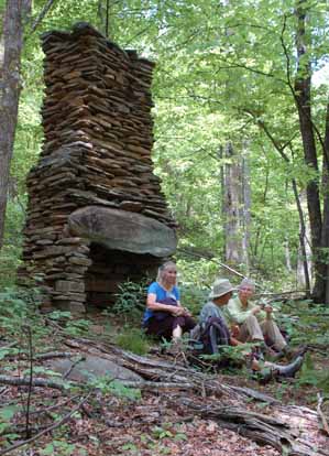
WEDNESDAY NO. W1102-636 May 25
Coontree-Bennett Gap-PressleyCove Lollipop *9:00 AM
Hike 8.4, Drive 75, 1900 ft. ascent, Rated B-A
Ashok Kudva, 828-698-7119, cell: 828-674-1374, ashok.kudva@att.net
P400 *Form carpools at Westgate, and meet leader at Pisgah Ranger Station at 9:35 AM. This hike goes up Coontree loop then follows Bennett Gap and Pressley Cove Trails, returning on right branch of Coontree Loop. Pace will be below average, faster hikers may proceed up to the next trail intersection. Topos: Shining Rock, Pisgah Forest; also NatGeo map #780
Eight hikers including a non-member enjoyed a great moderate hike. She had just moved to the area and was enthusiastic about our hiking territory. We enjoyed a lunch around the historic homestead chimney, a remnant of old farming community between Pressley Cove and Maxwell Cove. A snake we could not identify performed an acrobatic crawl on a bush during descent from Pressley Cove. This entertaining performance was followed by a better one during the descent on Coontree Trail; four ladies sang in unison. After the hike some of us paused at Dolly’s to treat ourselves with ice-cream. Photos by Ted Connors. Ashok
WEDNESDAY NO. W1102-367 June 1
Art Loeb, Grassy Cove Ridge to Bridges Camp Gap 8:30 AM
Hike 8.5, Drive 65, 1650 ft. ascent, Rated B-A
Laura Frisbie, 828-337-5845, laurafrisbie@charter.net
P400, SB6K Beginning with a climb up to Black Balsam (6214 ft.) we’ll follow the ridgeline to Tennent Mtn (6040 ft.) and Ivestor Gap. Then we’ll hike down Grassy Cove Ridge to the Big East Fork of the Pigeon River. Two stream crossings, one or both of which may be wet. End at Bridges Camp Gap. Car shuttle. This is a Wilderness area hike limited to ten people; please contact hike leader to reserve your place. Second meeting place: BRP Cold Mountain Overlook at 9:10 AM. Topo: Shining Rock; also NatGeo map #780
|
