CMC Bi-Weekly Hike News
September 27, 2006
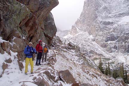
Wait a minute! This is not the Southern Appalachians. Read a trip report taken by 20 CMC members to Colorado.
| All Day Saturday and Sunday Hikes |
| Half Day Sunday Hikes |
| Wednesday Hikes |
Looking Back ... with hike reports
| All Day Saturday and Sunday Hikes |
| Half Day Sunday Hikes |
| Wednesday Hikes |
|
SATURDAY NO. A0603-527 Sept. 30 Chattooga River & Ellicott Rock 8:00 AM Hike 8.5, Drive 140, 950 ft. ascent, Rated B-C ALL DAY NO. A0603-528 Oct. 1 AT: Carmen – Allen Gap 8:00 AM (strenuous) Hike 13.5, Drive 95, 3300 ft. ascent, Rated AA-AA+ Charlie Ferguson, 828-398-0213, ccferguson111@charter.net and Bruce Bente, 828-692-0116, bbente@cytechusa.com A strenuous hike with great payback. This AT hike features great views from the Firescald Knob relo, Blackstock Cliff and White Rock Cliffs, and the Camp Creek Bald fire tower. The Fork Ridge Trail will be used to access the AT from the Carmen area. Key swap. Topos: Greystone, Davy Crockett Lake, Hot Springs; also Nat’l. Geo. French Broad & Nolichucky Rivers map ALL DAY NO. A0603-249 Oct. 1 Haywood Gap / Buckeye Gap 8:30 AM* (moderate) Hike 9, Drive 80, 1500 ft. ascent, Rated A-A Larry Modlin, 828-230-9282, lmodlin@warren-wilson.edu P400 *Note later start time. Follow MST, then scenic Haywood Gap Stream down on rough trail through the Middle Prong Wilderness to junction with Buckeye Gap Trail. Climb up onto ridge to more open forest, then follow old logging RR grade up. Wilderness area hike, limited to ten hikers—call leader for reservations. Second meeting place:BRP Cold Mtn. overlook at 9:00 AM. Topo: Sam Knob Nantahala Hiking and Rafting Weekend Oct. 6 - 8 We will stay at the Nantahala Outdoor Center in Wesser in the Nantahala Gorge. Challenging and moderate hikes are scheduled. In addition, you can raft and bike. This is also a perfect family weekend. All the information will be posted on the e-News including the planned hikes and reduced room rates. danny@hikertohiker.org HALF-DAY No. H0603-318
Oct. 1East Fork Pigeon River
1:00 PMNewcomers who have not hiked with CMC before are welcome,
but are required to phone the leader before the hike to determine hike requirements. Hike 5, Drive 74, Rated C-C
Renate Rikkers, 828-298-9988, Rerikkers@aol.com HALF-DAY No. H0604-436 Oct. 8Mt. Pisgah from the Pisgah Inn
1:00 PM* WEDNESDAY NO. W0603-531
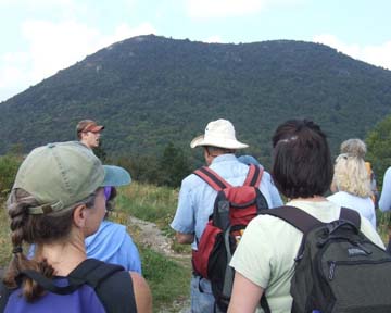
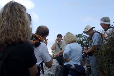
Sept. 27 Pisgah Inn to Beaverdam Overlook 9:00 AM* WEDNESDAY NO. NO. W0604-407 Oct 4 Dill Falls 8:00 AM* Hike 5, Drive 85, Rated C-C WEDNESDAY NO. NO. W0604-336 Oct 11 Mt. Cammerer from Big Creek 8:00 AM Hike 11.8, Drive 110, 3300 ft. Ascent, Rated A-AA Susanna Whitaker, 828-684-5948, susannwhit@earthlink.net 900M We will travel west on I-40 and take the Waterville Exit and continue a short distance to our trail head in the Big Creek area. This fantastic hike takes us up the AT which will take us to Mt. Cammerer, featuring the historic stone fire tower built according to the “Yosemite model” in the 1930’s: a CCC project. We will enjoy a lunch break on top and take in the expansive autumn views. The ascent is rather long, but the pace will be moderate. Return on same trails. Second meeting place: Pilot Truck Stop at exit 24 off I-40 at 8:30 am. Topo: Waterville; also Nat’l. Geo. GSMNP map ALL DAY NO. A0603-465 Sept. 10 Sam Knob Natural History Hike 9:00 AM* Hike 5, Drive 70, 1200 ft. ascent, Rated C-B Ruth Hartzler, 828-251-0886, ruthmtn@charter.net & Ben Prater, SABP P400, SB6K *Note later start time. This is a joint natural history hike with the Southern Appalachian Biodiversity Project. During the hike, Ecologist Ben Prater will stop frequently to describe natural features of the landscape. The hike starts at one of the highest trailheads in Western North Carolina. At 5800 ft., you’ll be hiking through a high-elevation environment more typical to southern Canada than the Southeast. We will pass through a large meadow before ascending Sam Knob (6040 ft.), a spectacular two-peaked mountain rising above the waters of Flat Laurel Creek and the surrounding meadows. While there is no true timberline in these mountains, “balds” like this have a hard time re-establishing themselves once cleared by fire or man. There is a grassy, shrubby saddle between the two knobs, and a large outcropping of white quartz juts from a meadow beside the trail. After Sam Knob, we will continue through meadows and hike back to our cars via the Flat Laurel Trail. Second meeting place: BRP Cold Mtn. overlook at 9:40 AM. Topo: Sam Knob; also Nat’l. Geo. PRD map
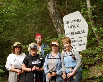
The cool, cloudy September weather did not deter twenty-eight hikers from joining CMC’s first Natural History Hike. We gathered hikers at Westgate, Cold Mountain Overlook, and the trailhead at Black Balsam Parking on FS816. Our leader, Ben Prater, an ecologist with the Southern Appalachian Biodiversity Project (SABP), described his plan for the day’s outing. We also introduced Chris Joyell and Tracy Davids from SABP, a non-profit organization dedicated to empowering citizens to appreciate, defend, and restore native biodiversity of the Southeast. About one-third of the participants were members of SABP. We headed down the trail toward Sam Knob. Ben stopped several times to point out fireweed and a hornet’s nest. He also explained the natural processes that formed the treeless areas on Sam Knob and the meadow at the base. Goldenrod and asters splashed fall yellows and purples along the way. On top of Sam Knob, Ben outlined the geologic processes that formed the Appalachians and Blue Ridge Mountains, and pointed out an example of quartz rock. Some hikers reported that we had bypassed a rattlesnake on the way up. We headed for the second knob, where we enjoyed lunch with a panoramic view that includes Devil’s Courthouse. The many shades of blue and purple mountains were enhanced by the dark gray clouds overhead. We also had the opportunity to ask questions and to get to know members of our guest organization. I shared some blueberries with the youngest member of SABP, about three years old, who made the trip on her Dad’s shoulders. The hike continued on the Flat Laurel Creek Trail. We socialized, enjoyed a little sunshine and more spectacular views. We had fun, learned some things, and observed, once more, why we are working to protect our exceptional hiking areas. Thanks again to Ben, Chris and Tracy. Their website is www.sapb.net. Photos taken by Ashok Kudva feature Ben Prater.--- Ruth ALL DAY NO. A0603-367 Sept. 17 Art Loeb, Grassy Cove Ridge to Bridges Camp Gap 8:00 AM Hike 9, Drive 65, 1000 ft. ascent, Rated A-B Stuart English, 828-883-2447, stuengo@citcom.net P400, SB6K Beginning with a climb up a short, steep manway to Black Balsam (6214 ft.) then follow the ridgeline to Tennent Mtn (6040 ft.) and Ivestor Gap. Then we’ll hike down Grassy Cove Ridge to the Big East Fork of the Pigeon River. Two wet stream crossings. From there we’ll hike to Skinny Dip Falls, and then end at Bridges Camp Gap. Short car shuttle required at end. This is a Wilderness area hike limited to ten people. Please contact hike leader to reserve your place. Second meeting place: Cold Mtn. overlook on BRP at 8:30 A.M. Topo: Shining Rock; also Nat’l. Geographic PRD map
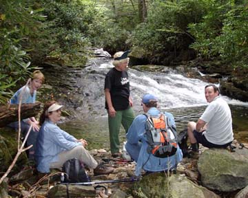
It was a beautiful, clear, cool September morning, when 15 of us set out on this great hike. It was not my intention to start a second group on this hike, but in the last week before the hike, the waiting list had was getting longer. Then Paul Benson wrote me wanting to go and eventually told me that he knew the hike and was willing to lead the second group. We allowed a 15 minute gap between us and the pristine beauty of the Shining Rock Wilderness remains unspoiled. The variety makes this a great hike. Starting with 360 degree views from 6000 foot peaks Black Balsam and Tennant, to the almost completely overgrown Greasy Prong Trail leading down a unique sedge grass covered ridge, and then down to two spectacular stream crossings before going back to the cars. This is my new favorite hike and certainly the favorite of the few that I've led. Also, as one hiker pointed out, there were no bee stings, snake bites, broken bones, or lost hikers. Seven of us capped it all off with a fine meal at the Pisgah Inn. Thanks to a great group for a memorable day. Stuart ALL DAY NO. A0603-091 Sept. 24 Black Mountains Circuit 8:00 AM Hike 8, Drive 65, 2000 ft. ascent, Rated B-A Becky Smucker, 828-298-5013, bsmucker@charter.net SB6K Beginning at Mt. Mitchell parking lot, we proceed south along the Old Mitchell Trail via a short bushwhack to Mt. Hallback (6320 ft.), then to 6571 ft. Mt. Gibbes We will return on the Commissary and Old Mt. Mitchell Trails and climb the tower on 6684 ft. Mt. Mitchell if it is still there. Second meeting place: Craven Gap ay 8:20 AM. Topos: Mt. Mitchell, Montreat Due to a terrible weather forecast for storms all day, the hike to the high peaks was cancelled. Those who did show up broke into two mini-groups and did a couple of shorter, lower elevation morning hikes in spite of the rain. We were disappointed but had a good time anyway. Becky Smucker HALF-DAY No.H0603-349 Sept. 10 Buck Spring Trail 1:00 PM*Newcomers who have not hiked with CMC before are welcome, but are required to phone the leader before the hike to determine hike requirements. Hike 6.2, Drive 50, Rated B-C Jean Gard, 828-777-1814, jeangard@charter.net Buck Springs Trail … Rescue 911 -
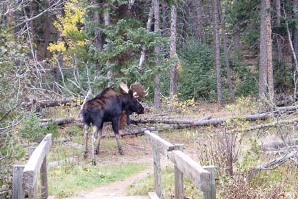
Hikers and Hike Leaders: Read This Report Luckily, Gail Lamb, a retired E.R. Physician was with us. She and Jere Pilver, an anesthesiology nurse, took over the man’s care. With the help of other hikers, they got the man’s feet up, his head down and checked his breathing, pulse and other vitals. Soon the man started vomiting. Meanwhile, Lucy Prim and Joan Kopp (first-time hiker and good runner) ran up the trail to try to find an Epipen at the lodge. They returned with one that a customer in the restaurant had donated, which had an expiration date of 2005. (Epipen is a doctor-prescribed insect-allergy medical device that costs about $100 and expires after one year.) Gail reported that the patient had no welts on his body and didn’t exhibit clear signs of insect allergy. She had concerns about using Epipen when other conditions, unknown to her, could have caused or contributed to the cause of the man’s collapse. So, she continued to carefully monitor his condition and soon the Brevard Rescue Squad arrived. They took vitals, talked to the man, administered an I.V. and decided to take him to the hospital for further care. They wrapped the patient in special thermal blankets, loaded him on the one-wheeled stretcher and 12 of them assisted in carrying him up the mile-long, steep, switch-backed path to the top. There, we were met by ambulance rescue workers who had an all-terrain vehicle that took him from the path to the ambulance. The five of us, including his wife, followed. Outside the inn, I gave a brief report to the park ranger handling the incident. The man’s wife thanked us all and promised to call and let us know how things turned out. Then, at last, the man was in the ambulance and on the way to the hospital with his wife. More Trouble On The Trail Meanwhile, the skies had broken open with huge thunder, lighting and rain storms. The woods became as dark as night. The stream crossings became wild. One of those fourteen hikers who had gone on to complete the hike had vision problems and was unable to see the rocks beneath his feet on the stream crossings. He also had not brought any rain gear and was using an umbrella! This negatively affected his balance and exposed him to the peril of a lightning strike. Gerry and Paula McNabb stepped up to help him, staying on either side of him and helping him across the many stream crossings, and over the 5 miles of trail that separated them from safety. Paula Robbins, our sweep, watched over him and guided him as well. Gail and I had driven to the end of Buck Springs Trail and met the first group of these hikers coming out of the woods at 5:45 P.M. They reported their frustration at the difficulties of waiting and worrying about the slow hiker. We all agreed that the trail had been too difficult for him and, consequently, very frustrating for them. Eventually Jorge Munoz went back into the woods, met up with Gerry, Paula M., Paula R. and the hiker. They emerged from the woods a full four hours after departing from the Inn. And this was a six-mile hike! By 6 P.M. we were all in our cars and headed to the Inn. Nine of us dined together and re-lived the day – feeling a mixture of exhaustion, relief and worry about our hiker in the hospital. We left about 8:30, thinking that our troubles were over for that day, anyway. Well. “It never rains but it pours,” as the old saying so aptly puts it. On Rita Hall’s post-dinner drive back to Hendersonville, she encountered a huge buck on the road, which she managed to avoid hitting head on. However, the deer did “side-swipe” her car causing her driver’s-side rear-view mirror to break off and her windshield to crack. She pulled over and so did Michael Corrn, who was behind her on the road. Luckily, Rita was not injured and was able to drive her car home. She was very glad that Michael had driven behind her and stopped to assist. So ends the September 10, 2006 Buck Springs Trail Hike. Follow-up on bee-sting victim: His wife called me the next day. Patient was covered with red welts by the time he reached the hospital. Doctor administered bee-sting allergy and anti-nausea medications. He wrote prescriptions and warned patient of the danger of any outdoor activity without carrying his medication. Doctor stated that more people died from bee-sting allergy than from rattle snake bites in this region. He emphasized the life-or-death nature of the patient’s allergy. Patient recovered and was discharged that evening. Lessons Learned: Insect Stings 1. If you are allergic to insect stings, always have your medications with you. Lessons Learned: Hike Preparedness and Hiking Ability 1. Always bring rain gear The end. Jean Gard -------------------------------- From Paula Robbins Jean’s leadership was exemplary. HALF-DAY No. H0603-222 Sept. 17Montreat Loop #3 1:00 PM*Hike 5, Drive 40, Elevation change 1200 ft.Rated C-BJoe Burchfield, 828-298-8413 (Note corrected phone number!) burchfield@niu.edu *Note early start time. We will ascend by the Graybeard Trail to the Old Trestle Road at Pot Cove Gap. We will then follow a newly cleared and opened section of the Old Trestle Road (not yet on most Montreat trail maps) to Graybeard Falls. We will return to Pot Cove Gap by a short steep section of the Graybeard Trail and then retrace our path to the parking area. There are nine dry-foot stream crossings on rocks and/or logs. Second meeting place: Parking lot adjacent to McDonald's off I-40 at exit 64 at 1:20 PM. On a beautiful Sunday afternoon seven of us * all CMC members* gathered at the Graybeard trailhead in Montreat. After the recent rain, the water in Flat Creek was high, and it provided a pleasant musical accompaniment as we followed it ascending through the rhododendrons along the Graybeard trail. Just below Pot Cove Gap, we turned left onto a newly cleared section of the Old Trestle road and followed a long switchback in a gradual ascent to Graybeard Falls. At our lunch spot we had an excellent southern vista over the valley through Montreat and Black Mountain to the Blue Ridge. High water made several of the stream crossings and parts of the trail a bit slippery, but we all made it with dry feet and without incident. All in all, it was beautiful afternoon’s hike in a surprisingly deserted part of Montreat. I might add that the newly opened section of the Old Trestle Road includes a second long switchback from Graybeard Falls to just below Walker’s Knob. We didn’t have time to hike this section on Sunday, but it’s well worth the walk. Joe HALF-DAY No. H0603-524 Sept. 24 Bent Creek Gap to Hard Times Road & BRP 1:30 PM Newcomers who have not hiked with CMC before are welcome, but are required to phone the leader before the hike to determine hike requirements. Hike 6.6, Drive 25, 1,000-ft elevation, Rated B-B Pat Elias, 828-687-1651, patelias@bellsouth.net This is a pleasant woods walk on the old Shut-In Trail portion of the MST. Car shuttle.Second meeting place: French Broad Overlook on the Blue Ridge Parkway at 1:45 PM. Hikers who are not familiar with how to get to second meeting place should phone leader for directions. Two hikers did meet me at the French Broad Overlook. One of the hikers, who is a member, introduced a friend from Florida to the CMC. We waited until 2:00 PM for other hikers and then, considering the time, the distance, and the weather, decided to hike nearby. We hiked up the Shut-In Trail, along Hard Times Road and the Bent Creek Trail, covering a nice-paced 5 miles. Pat WEDNESDAY NO. W0603-266 Sept. 6 MST: Black Mtn. Campground to NC 128 8:00 AM* The September 6 hike on the Mountain to Sea Trail from Black Mountain Campground to NC 128 was long and eventful. The weather was almost perfect with lots of views and and high clouds. Yellow Jackets played a major role during the hike with three hikers being stung. One of the victims showed some systemic symptoms. The first leg of the trek was steep with varied terrain and vegetation but lots of switchbacks. From Mount Mitchell to NC 128 the terrain was relatively flat through meadows and lots of streams and wetlands. Berry picking and wildflower viewing were part of the days events. Several of the hikers chose this hike to prepare for a trip to Rocky Mountain National Park and they all felt it was worth the effort. It was a great day and a great group of hikers. Ames WEDNESDAY NO. W0603-049 Sept. 13 Walnut bottom 8:00 AM Hike 11.6, Drive 110, 1500 ft. ascent, Rated A-B Ashok Kudva, 828-698-7119, ashok.kudva@mchsi.com 900M Follow the sight and sound of a spectacular mountain stream through a beautiful forest to Walnut Bottom. Features to be seen on this hike on a wide roadbed are the Midnight Hole, Mouse Creek Falls and several rapids. A shorter version (6 miles) will be offered if a minimum of 3 people wish to do so. Second meeting place: Pilot Truck Stop, I-40 at Exit 24 at 8:30 AM, but call leader first. Topos: Luftee Knob, Cove Creek Gap; also Nat'l. Geo .GSMNP Map Only one hiker showed up at Westgate on a very rainy day. We cancelled the hike. Ashok Kudva WEDNESDAY NO. W0603-479 Sept. 20 Kagel Mtn. 8:30 AM Hike 9, Drive 80, 1100 ft. ascent, Rated B-B Larry Ballard, 828-891-4318, leballard@cytechcis.net P400 This new CMC loop hike will start from Cathey’s Creek Rd. and follow an overgrown forest road to the Art Loeb Trail, with lunch at the Butter Gap shelter. We’ll return via a no-name trail for variety. Nice winter views. Second meeting place: Bi-Lo in Pisgah Forest at 9:00 AM Topos: Rosman, Shining Rock Colorado Hiking Trip Report - part 1. This is a summary and we hope to post a longer report in the next E-News. Twenty CMC hikers and friends just returned from a very enjoyable 11-day trip to Rocky Mtn. National Park in Colorado. 17 hikers stayed for the entire period, while three joined the group for part of the time. During this time, we hiked about 15 trails, hiking about 75 miles with a total ascent of about 15,000 ft. Weather ranged from 30 to 65 degrees, with winds up to 60 mph, and snow depth from zero up to knee-high. Many animals, large and small, were encountered along the way, both off-trail and on-trail. (This includes a moose family which had to be urged off the trail so hikers could pass.) -Reported by Bruce Bente All-day hikes submitted by Bruce Bente 692-0116, bbente@cytechusa.com . Driving distance is round-trip from Asheville. All Saturday and Sunday hikes assemble at Westgate Shopping Center near I-240 UNLESS OTHERWISE NOTED. Half Day hikes submitted by Paula Robbins 828-687-1651 paularww@bellsouth.net. Leaders: Mail please mail your sign-up sheets. Meet at Westgate unless otherwise noted. Wednesday Hikes are submitted by Paula McNabb, 828- 274-0057paulamcnabb@charter.net and Ann Gleason, 828-859-9387, cowbonetail@yahoo.com . The meeting place for each hike will be designated by the hike leader and will appear in the hike description. Driving mileage will be listed, round trip, from the first designated meeting place. |
|