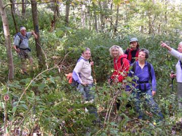
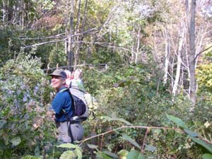
"Are we lost or what?" Pictures by Martha Hunter
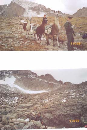
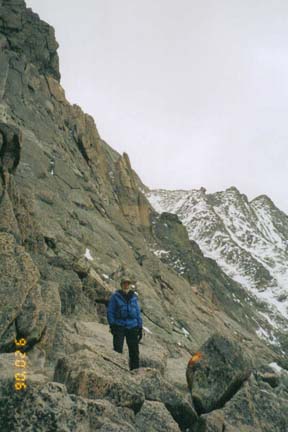
Read the full Colorado Trip Report- Taken by 20 CMC members
CMC Bi-Weekly Hike News
October 25, 2006
The Nantanhala Hiking and Rafting weekend - One more report
The tale of the Trail that wasn’t:
The group of eight ladies and myself arrived at the trail head in the Appletree Camp area prepared to have a pleasant day in the sunny weather with temps in the 60’s. We left the trail head at 9:20 am to start our journey on the Junaluska trail for a nice moderate hike.The trail went through a number of small streams with a low water level. We then took the Diamond Valley trail to the top of London Bald which entailed an approximately 800 – 900 ft steep elevation climb in two stages. We then took what seemed to be the correct trail with blue blazes, (although no signs) and a well used trail with a nice thread. After a mile or so we encountered what could be understated as the “trail from hell”. We encountered about a half mile of high weeds & brush with numerous fall downs. Even at this point the trail still had blue blazes indicating turns and the trail itself. It was one of the worst trail conditions that any of us seen!
We continued on (what else as we had gone a considerable distance) finding the trail in very good condition for the next few miles. At this point and prior to all this I began to seriously wonder about our eventual destination. Elevation levels and direction seemed to be correct. When the elevation levels started on the decline it became obvious that the final destination was not going to be the starting place as it should have been. This trail, by the way, is not indicated on any map.
As we came out of the woods at 4:25 pm into what I thought might be the Appletree Camp Ground but was instead the private Nelson Camp Ground on Hiway #74 near the junction of Hiway #129 to Robbinsville. There were several families from Georgia camping together and one of the gentlemen took the drivers to our original starting point which was a 30 minute drive one way. Unfortunately, due to being out of town prior to the hike I was not able to scout the hike which led to the hike not coming out as planned. Another example of the importance of scouting a hike prior to leading one. I take full responsibility for this extra time and difficulty encountered.
Fortunately no one was hurt in any way and we belatedly arrived safely. What a great group of beautiful ladies who endured all this with nary a complaint! Would you believe that we all felt that it turned out to be a great experience? It will be one of those hikes that will be remember!
After down loading my GPS readings to the software program I discovered that (duh!) the mistake took place somewhere on London Bald. I definitely plan to scout this hike for future use. Maybe I will be able to rectify myself by leading it the next time out. Many, many thanks to Pat, Martha, Linda, Jan, Linda, Teresa, Renate & Linda for the much appreciated support and sportswomenship displayed. Carroll
"Are we lost or what?" Pictures by Martha Hunter
Read the full Colorado Trip Report- Taken by 20 CMC members
| All Day Saturday and Sunday Hikes |
| Half Day Sunday Hikes |
| Wednesday Hikes |
Looking Back ... with hike reports
| All Day Saturday and Sunday Hikes |
| Half Day Sunday Hikes |
| Wednesday Hikes |
|
SATURDAY No. A0604-422 Oct. 28 Big Laurel - Pump Gap 9:00 AM* Hike 7, Drive 70, 2400 ft. ascent, Rated B-AA Amy Treverton, 828-298-1882, athikerbabe@yahoo.com *Note later start time. Starting at Hurricane, we’ll hike the Big Laurel Creek trail down to the French Broad River, then up Pump Branch to Pump Gap, and the AT past Lover’s Leap before ending at the hot tubs in Hot Springs. Nice scenery along the creeks and river. Bring your swimsuit and plan on stopping at either the hot tubs and/or supper. Please contact Amy if you plan to use the hot tubs so she can make reservations. Car shuttle. Topo: Hot Springs; also Nat’l. Geo. French Broad & Nolichucky Rivers map ALL DAY No. A0604-217 Oct. 29 Sandy Mush Bald Ramble 8:00AM Hike 9.5, Drive 40, 3100 ft. ascent, Rated A-AA+ Rob Resnick 828-255-8066 rob@reschiro.com Sarah Carothers 828-586-3282 sjcarothers@hotmail.com After dividing our group in two for a key swap hike, one group will ascend up Surritt Cove. The other group will hike up Long Branch Cove and both groups will traverse the ridge tops of the Newfound Mountains with their great views to reconnoiter for lunch atop Sandy Mush Bald. Some cross-country hiking required, and be prepared to cross a few barbed-wire fences. Thanks to Long Branch Environmental Education Center for providing access and coordinating permission from contiguous landowners. If the weather is clear, the views do not get any better! Topos: Sandy Mush, Fines Creek ALL DAY No. A0604-406 Nov. 5 Pink Beds to Clawhammer and Return 8:30 AM* (strenuous) Hike 8, Drive 86, 2300 ft ascent, Rated B-AA Tom Sanders, 828-252-6327, tomary2@charter.net P400 *Note later start time We will climb from the Pink Beds (FS 477) to Club Gap. Then we take the Black Mt. Trail, climbing through Buckhorn Gap and along the ridge to the overlook at Clawhammer Mt. for lunch and 180 degree views. *Meet at Westgate at 8:30 AM to form carpools, and meet leader at Pisgah Ranger Station at 9:00 AM. Topos: Shining Rock, Pisgah Forest; also Nat’l. Geo. PRD map ALL DAY No. A0604-526 Nov. 5 Down the Incline 8:40 AM* (moderate) Hike 8, Drive 80, 1350 ft. ascent, Rated B-B Tom Bindrim & Joan Lemire, 828-273-3880 P400 This hike is being repeated for those who missed it last time. Some off-trail; historic; wilderness area, limit 10, so call leader for reservation. Are you inclined? *Note later start time. Meet at Westgate at 8:40 AM to form carpools, and meet leader at second meeting place (phone leader for location.). Topo: Sam Knob; also Nat’l. Geo. PRD map HALF-DAY No. H0604-062 Oct. 29 Daniel Ridge Loop Trail 1:00 PM* P400 *Note early start time. After scrambling across the Davidson River on stones because of the washout of the bridge in Hurricane Ivan, the trail climbs gradually beside a lovely stream with small waterfalls. A larger waterfall is seen just before the end of the hike. *Note: If the river is flooded, a different hike will be chosen. Second meeting place: Fish Hatchery parking lot off FS475 at 1:45 PM. HALF-DAY NO. H0604-533 Nov. 5 Looking Glass Overlook to Wagon Road Gap on the MST 1:00 PM*Drive 70, Hike 5, 1500 ft. Ascent, Rated C-ANonmembers, call leader, Ruth Hartzler, 828-251-0886, ruthmtn@charter.net P400 *Note early start time. This moderate one-way hike features great views from Green Knob. Second meeting place: BRP Wagon Road parking area (M.P. 412) at 1:40PM. Short car shuttle. WEDNESDAY NO. NO. W0604-540 Oct 25 MST: Buckeye Gap to FS 816 8:00 AM Hike 10, Drive 70. Rated A-A Jack Fitzgerald, 828-685-2897, suejackfitz@bellsouth.net P400 Beautiful walk in woods, around Mt. Hardy and Chestnut Bald. Views from Silvermine Bald area. Short car shuttle. Second meeting place: Cold Mountain overlook at 8:40 AM. Topo: Mt. Hardy; also Nat’l. Geo. PRD map WEDNESDAY NO. NO. W0604-089 Nov. 1 Max Patch 8:00 AM Hike 11, Drive 100, 1800 ft. ascent, Rated A-A Adrian Lotherington, 828-350 8065, jaloth@bellsouth.net A late fall hike that may be our last opportunity to scale this beautiful section of the AT before Jack Frost descends! We will begin and end at Max Patch, one of WNC's most stunning views. Second meeting place: Pilot Truck Stop at exit 24 off I-40 at 8:30 AM. Topo: Lemon Gap. WEDNESDAY NO. NO. W0604-438 Nov 8 Rich Mtn., Round Top Ridge Trail, Lover’s Leap 8:00 AM Hike 9.5, Drive 70, Rated A-B Don Walton, 828-654-9904, donwalton@bellsouth.net From Tanyard Gap we will go north on the AT to the beautiful Rich Mountain views, then descend to Hot Springs via Round Top Ridge Trail, and culminate the day with a short climb to Lover's Leap, finishing on the AT in Hot Springs. ALL DAY No. A 0604-082 Oct. 15 The Blacks Beyond 6000 7:30 AM (strenuous) Hike 11.3, Drive 125, 3,000 ft. (northbound) or 6,000 ft. (southbound) ascent, Rated AA-AA+ Charlie Ferguson, 828-398-0213, ccf108@gmail.com (southbound) & Don Gardner 828-754-4067 gardog3@charter.net (northbound) SB6K Note earlier starting time. Key-swap hike. This is your chance to bag seven SB6K peaks on this very strenuous hike. The southbound initial climb is 3100 ft., and there’s much more climbing in the ups and downs between peaks. North-bounders get to go down the 3100 ft. The hike is great fun with incomparable views, but do not consider this unless you are in top shape. Bring extra water. Participants should phone a leader beforehand. Second meeting place: Phone leader. Topos: Celo, Mt. Mitchell; also PNF South Toe River, Mount Mitchell & Big Ivy Trail Map The southbound group of 5 strong hikers started up the Black Mountain Crest Trail from Bowlens Creek. It was 32 degrees F and blue skies above. This was a steady 3,100 foot climb over 4.2 miles which would be a very strenuous hike by most standards. For us that was the warm-up. As we arrived at the top, ahead of schedule, we received our first of many spectacular views of the Crest Ridge and mountains of western North Carolina. The rest of our hike was in front of us - Celo, Horse Rock, Gibbs, Winterstar, Potato Hill, Cattail Peak, Balsam Cone, Big Tom, Mt. Craig and Mt. Mitchell. We arrived at the short manway to Celo Knob and decided to skip going to the top since most of us had been there before. We made sure the entrance to the manway was well marked for the northbound group. North Bound. It was a beautiful day and crystal clear. The Fall colors were in reasonable splendor and we could see for miles and miles. We had a total of 11 hikers, 6 who headed Northbound and 5 Southbound. The keyswap came off without a hitch. The trail was overgrown in many areas, especially between Deep Gap and Celo. This is obviously the lesser traveled portion of the trail. There are new signs up at several junctions that are very nice. Charlie had done a great job in clearing the bushwack manway up to the summit of Gibbs, having scouted it a few weeks earlier. We thus bagged seven (7) 6,000 footers on this hike, which is one of the great Club hikes. On the way to Mt. Mitchell we saw a number of wild turkeys and a gray fox. No Report HALF DAY No. H0604-381 Oct. 15 Snowball Trail 1:00 PM* Nonmembers call leader, Jorge Munoz, 828-658-0606, jmunoz@buncombe.main.nc.us *Note early start time. This is a moderate in-and-out hike with a nice steady climb to High Rocks (Hawkbill Mtn.). Diverse and centennial trees to be admired all the way on the ridge. Stop for a snack at Snowball Mountain before return. Second meeting place: Craven Gap on Blue Ridge Parkway at 1:20 PM. Eighteen hikers turned out for a magnificent day on the trail. We had perfectly cool temperatures, a crystal clear sky, and good comradarie. Starting at Beetree Gap we climbed up and over Snowball Mtn. (about 5,200') then dropped down along a ridgeline before climbing Hawkbill Rock. There we had a snack and admired the stunning views in all directions. Fall color was good but not at peak. After a break we continued on down Hawkbill Rock toward Smowball Gap and Little Snowball Mtn. Lack of time forced us to turn around before we reached Snowball Gap. We retraced our steps and once again stopped to admire the view from Hawkbill Rock. We returned to the trailhead about 6:00 p.m. just as the air was becomming noticeably cooler. Great day enjoyed by all! John Whitehouse for Jorge Munoz. HALF DAY No. H0604-464 Oct. 22 Balsam Gap to Greybeard Overlook 1:00 PM* *Note early start time. Although the distance on this portion of the Mountains-to-Sea Trail is not long, this hike provides a good workout, with 400 feet ascending and 700 descending, with great views midway. Short car shuttle. *Only meeting place: Folk Art Center lower parking lot. No Report WEDNESDAY NO. NO. W0604-336 Oct 11 Mt. Cammerer from Big Creek 8:00 AM Hike 11.8, Drive 110, 3300 ft. Ascent, Rated A-AA Susanna Whitaker, 828-684-5948, susannwhit@earthlink.net 900M We will travel west on I-40 and take the Waterville Exit and continue a short distance to our trail head in the Big Creek area. This fantastic hike takes us up the AT which will take us to Mt. Cammerer, featuring the historic stone fire tower built according to the “Yosemite model” in the 1930’s: a CCC project. We will enjoy a lunch break on top and take in the expansive autumn views. The ascent is rather long, but the pace will be moderate. Return on same trails. Second meeting place: Pilot Truck Stop at exit 24 off I-40 at 8:30 am. Topo: Waterville; also Nat’l. Geo. GSMNP map
WEDNESDAY NO. NO. W0604-539 Oct 18 Downhill to Pilot Mtn. 8:00 AM Hike 6, Drive 88, 2200 ft. ascent, Rated B-AA Dave Wetmore, 828-884-7297, dwetmore@citcom.net P400 Downhill to Pilot Mountain! We’ll take the Art Loeb Trail from the parkway through Farlow and Deep Gaps to the magnificent views from the summit of Pilot Mountain. Then uphill from Pilot Mountain. If the weather cooperates, it should be a lovely hike. Second meeting place: Pisgah Ranger Station at 8:35 AM. Topo: Shining Rock; also Nat’l. Geo. PRD map After waiting in the fog at Westgate until 8:05, the leader drove to the Pisgah Forest Ranger station to find nine hikers waiting.The weather was sunny and warm, the leaves were colorful, and the views from Pilot Mtn. were excellent. In other words, a pleasant and beautiful hike. Dave All-day hikes submitted by Bruce Bente 692-0116, bbente@cytechusa.com . Driving distance is round-trip from Asheville. All Saturday and Sunday hikes assemble at Westgate Shopping Center near I-240 UNLESS OTHERWISE NOTED. Half Day hikes submitted by Paula Robbins 828-687-1651 paularww@bellsouth.net. Wednesday Hikes are submitted by Charlie Ferguson, 828-398-0213 ccferguson@email.com and Ann Gleason, 828-859-9387, cowbonetail@yahoo.com . The meeting place for each hike will be designated by the hike leader and will appear in the hike description.
Driving mileage will be listed, round trip, from the first designated meeting place. |
|
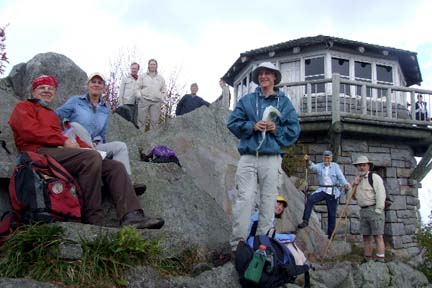 Fourteen of us gathered to conquer MT Cammerer. Early morning was a bit foggy and overcast. We did encounter scant drizzle one half hour or so into the hike, but then Mother Nature cooperated and gave us a spectacular early fall day. A new hiker from the NC Piedmont region joined us and liked it so well that he has since joined CMC. Other events along the way included one developing rather severe leg cramps. He readily volunteered to drop out and meet us on the way back or other options that would not detain our hike. Instead, we gave him water with electrolytes, massage and then stretching. After a few minutes, all of us were on our way. A few of the other men even "felt some minor cramping as well" after observing a couple of the women administering leg massage. Others enjoyed the brief rest before resuming our 3,000+ foot climb.