ALL DAY No. A0604-270 Nov. 12 Cedar Rock Mtn.- John Rock Loop 8:30 AM* Hike 8, Drive 80, Rated B-A Carroll Koepplinger, 828-667-0723, carrollkoepp@bellsouth.net P400 *Note later start time. This trip features two of the spectacular rock summits in the Pisgah Forest, with great views from both. Starting at the Fish Hatchery, we’ll have our major climb up to Cat Gap and then on to Cedar Rock for lunch. We’ll return via John Rock. Second meeting place: Pisgah Fish Hatchery at 9:10 AM. Topo: Shining Rock.
ALL DAY No. A0604-535 Nov. 19 Indian Creek – Sunkota Ridge loop 7:30 AM* Hike 12, Drive 135, 2000 ft. ascent, Rated A-A Marianne Newman, 828-454-1036, marianneln@msn.com 900M *Note early start time. Form carpools at Westgate at 7:30 AM and meet leader at rest area on US23/74 beyond Waynesville at 8:00 AM. We’ll make a loop using Indian Creek and Martin’s Gap trails, then down Sunkota Ridge and Deep Creek Trails, admiring three waterfalls and lovely winter views (if the weather cooperates) of Noland and Thomas Divides. Since the hike is long and the daylight is short, a fairly brisk pace will prevail. Topos: Bryson City, Clingman’s Dome; also Nat’l. Geo. GSMNP map
HALF-DAY NO. H0604-434 Nov. 12 Laurel Mountain Trail
1:00 PM* Hike 4-5 miles, Drive 40, Rated C-CNonmembers, call leader, Greg Goodman, 828-684-9703
P400 *Note early start time This loop hike will start at FS 1206, go along a ridge trail toward Black Mountain and return via the Laurel Mountain Trail. There should be good views of the Mills River Valley.. *Meet at Westgate at 1:00 PM to form carpools (call leader if not familiar with second meeting place); meet leader at the North Mills River parking area at 1:30 PM.
HALF-DAY No. H0604-522 Nov. 19 Hot Springs Loop
1:00 PM* Nonmembers, call leader, Don Walton, 828-298-5084,
donwalton@bellsouth.net Hike 3.6, Drive 90, 1000 ft/. Ascent, Rated C-B
*Note early start time. From the campground along the Vann Cliff Trail the loop ascends to nice views of Hot Springs and the French Broad River Valley, passes Spring Creek and then returns to the campground.
WEDNESDAY NO. NO. W0604-438 Nov 8 Rich Mtn., Round Top Ridge Trail, Lover’s Leap 8:00 AM Hike 9.5, Drive 70, Rated A-B Don Walton, 828-654-9904, donwalton@bellsouth.net From Tanyard Gap we will go north on the AT to the beautiful Rich Mountain views, then descend to Hot Springs via Round Top Ridge Trail, and culminate the day with a short climb to Lover's Leap, finishing on the AT in Hot Springs.
WEDNESDAY NO. NO. W0604-408 Nov 15 Wolf Ford Loop Hike 8:00 AM* Hike 9, Drive 80, 1200 ft. ascent, Rated B-B Greg Goodman, 828-684-9703 P400 *Meet at Westgate at 8:00 AM to form carpools, and meet leader at Pisgah Ranger Station at 8:30 AM. Start at the gauging station and hike south Mills River trail to Wolf Ford, Squirrel Gap, Horse Cove and to FS 5018, then along Funnel top Ridge left onto Soapstone Ridge and back to cars. Topo: Shining Rock; also Nat’l. Geo. PRD map
WEDNESDAY NO. NO. W0604-406 Nov 22 Pink Beds to Clawhammer Mtn 8:30 AM Hike 8, Drive 86, 2300 ft. ascent, Rated B-AA Charlie Ferguson, 828-398-0213,.ccf108@gmail.com P400 The trailhead is at the Pink Beds parking lot (FS477). Climb on the Club Gap trail to Club Gap. Then take the Black Mt. Trail along Rich Mtn., climbing through Buckhorm Gap and along the ridge to the overlook at Clawhammer which has great views. That will be our lunch stop. Then return the way we came. We will take our time while climbing. Second meeting place: Pisgah Ranger Station at 9:00 AM. Topo: Shining Rock; also Nat’l. Geo. PRD map
SATURDAY No. A0604-422 Oct. 28 Big Laurel - Pump Gap 9:00 AM* Hike 7, Drive 70, 2400 ft. ascent, Rated B-AA Amy Treverton, 828-298-1882, athikerbabe@yahoo.com *Note later start time. Starting at Hurricane, we’ll hike the Big Laurel Creek trail down to the French Broad River, then up Pump Branch to Pump Gap, and the AT past Lover’s Leap before ending at the hot tubs in Hot Springs. Nice scenery along the creeks and river. Bring your swimsuit and plan on stopping at either the hot tubs and/or supper. Please contact Amy if you plan to use the hot tubs so she can make reservations. Car shuttle. Topo: Hot Springs; also Nat’l. Geo. French Broad & Nolichucky Rivers map
"Weather be damned" was the motto of the day! Six intrepid hikers decided to let mother nature do what she wanted. The day began with some rain showers, wind, and was also cold! Once we got a move on down the Laurel River Trail we warmed up a bit. Then the climb started up the Pump Gap Trail and extra clothing was put away. We had a cold, windy lunch spot at the intersection of the AT and Pump Gap Trail, but shortly the sun began to come out and it was rather pleasant the rest of the day. We stopped at Lover's Leap so some hikers, who had never been there, could climb out on the rocks. We dined at the deli and checked out the outfitters store. Three of us went to soak in the hot tubs - oh so relaxing!!!
Amy .... Photos by Ashok Kudva
ALL DAY No. A0604-217 Oct. 29 Sandy Mush Bald Ramble 8:00AM Hike 9.5, Drive 40, 3100 ft. ascent, Rated A-AA+ Rob Resnick 828-255-8066 rob@reschiro.com Sarah Carothers 828-586-3282 sjcarothers@hotmail.com After dividing our group in two for a key swap hike, one group will ascend up Surritt Cove. The other group will hike up Long Branch Cove and both groups will traverse the ridge tops of the Newfound Mountains with their great views to reconnoiter for lunch atop Sandy Mush Bald. Some cross-country hiking required, and be prepared to cross a few barbed-wire fences. Thanks to Long Branch Environmental Education Center for providing access and coordinating permission from contiguous landowners. If the weather is clear, the views do not get any better! Topos: Sandy Mush, Fines Creek
No report.
ALL DAY No. A0604-406 Nov. 5 Pink Beds to Clawhammer and Return 8:30 AM* (strenuous) Hike 8, Drive 86, 2300 ft ascent, Rated B-AA Tom Sanders, 828-252-6327, tomary2@charter.net P400 *Note later start time We will climb from the Pink Beds (FS 477) to Club Gap. Then we take the Black Mt. Trail, climbing through Buckhorn Gap and along the ridge to the overlook at Clawhammer Mt. for lunch and 180 degree views. *Meet at Westgate at 8:30 AM to form carpools, and meet leader at Pisgah Ranger Station at 9:00 AM. Topos: Shining Rock, Pisgah Forest; also Nat’l. Geo. PRD map
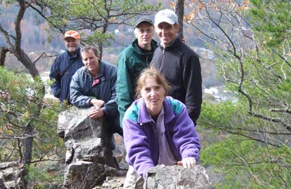
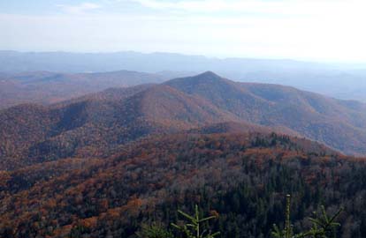
Nine people participated in this hike on a superb fall day. Starting at Pink Beds we altered the description by ascending on the MST Alternate (Barnett Branch Trail) to the ridge at the Black Mountain Trail. We then proceded south across Clawhammer to our lunch spot on a rock face in the saddle between Clawhammer and Black Mtns. Throughout, views were outstanding, especially of the ridge along the BRP and across the Ranger District to features like Cedar Rock, Pilot Mtn., and Looking Glass Rock. An initially chilly day warmed up during the morning so that we got good sunbaths during lunch. On our return we retraced our course but continued on the Black Mtn Trail to Club Gap Trail and then down to where we were parked. The hike is listed at 8 miles, but is probably about 10 the way we went. This was one of those days that makes Nov. one of our best hiking months. Tom
ALL DAY No. A0604-526 Nov. 5 Down the Incline 8:40 AM* (moderate) Hike 8, Drive 80, 1350 ft. ascent, Rated B-B Tom Bindrim & Joan Lemire, 828-273-3880 P400 This hike is being repeated for those who missed it last time. Some off-trail; historic; wilderness area, limit 10, so call leader for reservation. Are you inclined? *Note later start time. Meet at Westgate at 8:40 AM to form carpools, and meet leader at second meeting place (phone leader for location.). Topo: Sam Knob; also Nat’l. Geo. PRD map
No report
HALF-DAY No. H0604-062 Oct. 29 Daniel Ridge Loop Trail 1:00 PM*
Drive 70, Hike 4, 800 ft. Ascent, Rated C-CNonmembers, call leader, Pat Elias, 828-687-1651; patelias@bellsouth.net
P400 *Note early start time. After scrambling across the Davidson River on stones because of the washout of the bridge in Hurricane Ivan, the trail climbs gradually beside a lovely stream with small waterfalls. A larger waterfall is seen just before the end of the hike. *Note: If the river is flooded, a different hike will be chosen. Second meeting place: Fish Hatchery parking lot off FS475 at 1:45 PM.
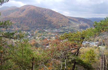
The group met the hike leader at the Fish Hatchery around 1:50 PM where, for various reasons, it was decided to hike John Rock rather than Daniel Ridge. Seventeen hikers enjoyed the up/down trek to John Rock where we snacked, viewed Looking Glass Rock, the waning fall colors, and a graceful hawk floating on the cool breezes. Although the hike ended at 5:00 PM, it was somewhat dark in the woods, which made me aware that a later start, a longer hike, or an unexpected delay on the hike might have been an unpleasant experience. Pat
HALF-DAY NO. H0604-533 Nov. 5 Looking Glass Overlook to Wagon Road Gap on the MST 1:00 PM*Drive 70, Hike 5, 1500 ft. Ascent, Rated C-ANonmembers, call leader, Ruth Hartzler, 828-251-0886, ruthmtn@charter.net
P400 *Note early start time. This moderate one-way hike features great views from Green Knob. Second meeting place: BRP Wagon Road parking area (M.P. 412) at 1:40PM. Short car shuttle.
No report
WEDNESDAY NO. NO. W0604-540 Oct 25 MST: Buckeye Gap to FS 816 8:00 AM Hike 10, Drive 70. Rated A-A Jack Fitzgerald, 828-685-2897, suejackfitz@bellsouth.net P400 Beautiful walk in woods, around Mt. Hardy and Chestnut Bald. Views from Silvermine Bald area. Short car shuttle. Second meeting place: Cold Mountain overlook at 8:40 AM. Topo: Mt. Hardy; also Nat’l. Geo. PRD map
No report. Photos by Ashok Kudva
WEDNESDAY NO. NO. W0604-089 Nov. 1 Max Patch 8:00 AM Hike 11, Drive 100, 1800 ft. ascent, Rated A-A Adrian Lotherington, 828-350 8065, jaloth@bellsouth.net A late fall hike that may be our last opportunity to scale this beautiful section of the AT before Jack Frost descends! We will begin and end at Max Patch, one of WNC's most stunning views. Second meeting place: Pilot Truck Stop at exit 24 off I-40 at 8:30 AM. Topo: Lemon Gap.
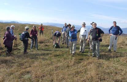
No report. Photo by Ashok Kudva
All-day hikes submitted by Bruce Bente 692-0116, bbente@cytechusa.com . Driving distance is round-trip from Asheville. All Saturday and Sunday hikes assemble at Westgate Shopping Center near I-240 UNLESS OTHERWISE NOTED.
Half Day hikes submitted by Paula Robbins 828-687-1651 paularww@bellsouth.net.
Wednesday Hikes are submitted by Charlie Ferguson, 828-398-0213 ccferguson@email.com and Ann Gleason, 828-859-9387, cowbonetail@yahoo.com .
The meeting place for each hike will be designated by the hike leader and will appear in the hike description.
Driving mileage will be listed, round trip, from the first designated meeting place.
Leaders: Mail please mail your sign-up sheets. Meet at Westgate unless otherwise noted.