ALL DAY No. A0604-394 Dec. 10 Cataloochee and Little Cataloochee 8:00 AM Hike 8, Drive 95, 2350 ft. ascent, Rated B-AA Dave Wetmore 828-884-7296 dwetmore@citcom.net 900M Walk the “Dug Road”, originally built in the 1850s. See an unrestored farm site, a restored log cabin, the old apple house, an old church and tourists looking for elk. The Dug Road is a mostly open easy 2.7 mile bushwhack on an abandoned trail. The rest of the trip is on maintained trails. Topo: Cove Creek Gap; also Nat’l. Geo. map of GSMNP
ALL DAY No. A0604-254 Dec. 17 Green Knob via Snooks Nose 8:00 AM Hike 11, Drive 65, 3400 ft. ascent, Rated A-AA+ Joanne Tulip, 828-299-3495, tulipinnc@aol.com This strenuous trip from Curtis Creek climbs up and over the Blue Ridge Parkway to the Green Knob fire tower. Great views along the way as well as at the lunch stop on the summit of Green Knob. We’ll return via the Newberry Creek Trail. May be challenging if there is snow at the higher elevations. Short car shuttle. Topo: Old Fort
HALF-DAY No. H0604-102 Dec. 10 Coontree Loop 1:00 PM*
Hike 3.7, Drive 70, Elevation gain 1200 ft. Ascent, Rated C-BNonmembers, call leader, Gerry McNabb, 828-274-0057, gerrymcnabb@charter.net
P400 *Note early start time This hike is a loop along both sides of a lovely creek, with views along Coontree Mtn. ridge on top. Some steep areas. Second meeting place: Ranger Station on US 276 at 1:40 PM.
HALF DAY No. H0604-325 Dec. 17 Tanyard Gap to Rich Mountain 1:00 PM*
Hike 5, Drive 64, 1365 ft. Ascent, Rated C-B
Nonmembers, call leader, Tom Sanders, 828-252-6327, tomary2@charter.net
*Note early start time. After a gradual climb on the Appalachian Trail, we will be rewarded with an outstanding view of the Hot Springs area from the fire tower.
WEDNESDAY NO. NO. W0604-471 Dec 6 Wagon Road Gap,MST to Big East Fork 8:00 AM Hike 9.5, Drive 85, 1500 ft. ascent, Rated A-A Tom Sanders, 828-252-6327, tomary2@charter.net Starting at Wagon Road Gap, we will follow the MST south to the connector to the Big East Fork Trail and follow that down to US 276. Short car shuttle. Wilderness area hike, limited to ten hikers—call leader for reservations. Second meeting place: Cold Mtn. overlook at 8:40 AM. Topo: Shining Rock; also Nat’l. Geo. PRD map. "Wilderness area hike, limited to ten hikers--call leader for reservation"
WEDNESDAY NO. NO. W0604-492 Dec 13 Cookie Hike in the Arboretum Area 9:10 AM* Hike 7-8, Drive 12, 1000 ft. ascent, Rated B-C Ken and Carol Deal, 828-281-4530, kmcdeal@aol.com Note later start time. Bring a few homemade goodies to share. We will hike on trails constructed by the CMC in the Arboretum and cover some trails in the Lake Powhatan area also. Bring your Arboretum membership card if you have one. There is a $6 parking fee otherwise. Second meeting place: Ingles parking lot across from Biltmore Square at 9:15 AM. Topo: Asheville: also Nat’l Geo PRD map and Bent Creek Trail Map
WEDNESDAY NO. NO. W0604-279 Dec 20 Montreat: RR trestle Grade to Pot Cove 9:00 AM* Hike 7, Drive 35, 1000 ft. ascent, Rated B-C Gerry McNabb,828-274-0057, gerrymcnabb@charter.net *Note later start time. An easy in and out hike to Pot Cove from the lookout Trail parking lot. Some internal loops for variety. Second meeting place: Parking lot adjacent to Black Mtn McDonalds just south of I-40 exit 64 at 9:30 AM. Topo: Montreat
BACKPACK No. A0604-536 Nov. 24 - 26 Backpack in the Smokies: Newfound Gap – Davenport Gap Hike 31.3, Drive 250, 5500 ft. ascent, Rated AA+-AA+ Paul Benson, 828-251-1909, pdbenson@charter.net 900M This is a challenging three-day backpack. We will traverse the eastern half of Great Smoky Mountains National Park via the Appalachian Trail. The views should be outstanding from this high ridgeline. Expect winter conditions. Day 1: We will drop a vehicle at Davenport Gap and drive up to Newfound Gap where we will hike the AT 10.4 miles to the Pecks Corner shelter; Day 2: Continue on the AT 12.9 miles to the Cosby Knob shelter; Day 3: Continue on the AT 8 miles to Davenport Gap. Participants must be experienced in cold weather backpacking, be strong hikers and have a spirit of adventure. We will cross a remote area from which rescue is extremely difficult. Meeting place and time: Call leader. Space is limited to eight hikers so please verify that you can attend before reserving a spot. Topos: Clingman’s Dome, Mt. LeConte, Mt. Guyot, Luftee Knob, Hartford; also Nat’l. Geo. GSMNP map
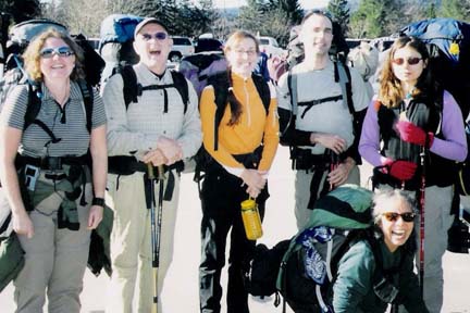 After some ebb and flow on the waiting list we ended up with a group of 7: Angie, Angela, Bill, Dolores, Don, Jennifer and me. We met at 7am at the Big Creek Ranger station, left some vehicles and headed up to Newfound Gap. Two hours later, after gas stops (another story) and food stops, we made it to the trail head at 10 am, about an hour later than I would have liked to start our 11.8 mile first day.
After some struggling with icy conditions (worse than I expected) but with spectacular clear, sunny warm weather, and a nice lunch break at a busy Icewater Spring shelter, we all made it to the Pecks Corner shelter with only some minor slipping and sliding, some of us arriving just as it was getting dark. With a full shelter and a nice fire we enjoyed lively conversation and even livelier snoring.
The second day brought the same spectacular weather, much less ice on the trail and a very long hard day of hiking. With 13.3 miles and about a 2500’ elevation gain with full packs we all had a definite physical challenge. But with endless views around every corner the rewards were as great as the challenge. Two lunch breaks helped, the first near Tricorner Knob before climbing Mt. Guyot and the second at spectacular Deer Creek Gap, after descending Old Black. We all made it to the Cosby Shelter without incident, again with stragglers arriving just before dark. (By the way this shelter has just been rebuilt and is very nice.) Thanks to Angela we had a great fire for telling stories around. We shared the shelter with only 1 person, a southbound through-hiker.
The final day returned the same awesome weather, no ice on the trail and only an 8.3 mile hike, (amazing that 8.3 miles with a pack would seem short), taking the AT past Mt Cammerer and descending the Chestnut Creek trail to the Big Creek ranger station. Blisters, sore knees and sore shoulders were beginning to take their toll on us weekend warriors, but the hike was the easiest yet even though it still involved a lot of uphill. Several snack breaks also helped. We finished pretty much together around 2 pm. We then proceeded up to Newfound Gap, sorted out gear, posed for a victory photo, and headed for home with a renewed appreciation of hot showers and pizza. Paul. Picture by Paul Benson
SATURDAY No. A0604-278 Nov. 25 Kitsuma Peak 9:00 AM* Hike 8, Drive 60, 2000 ft. ascent, Rated B-AA Tom Sanders, 828-252-6327, tomary2@charter.net *Note later starting time. Our hike up Young’s Ridge offers great views of Greybeard, Green Knob and the Mt. Mitchell area. Also there’s a grandstand view of the Swannanoa valley from our lunch spot. Second meeting place: parking lot adjacent to McDonald’s in Black Mtn. (I-40 exit 64) at 9:20 AM. Topos: Old Fort, Black Mtn.
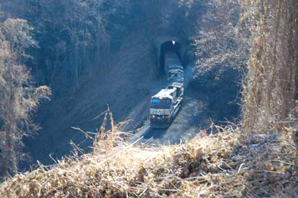 On a perfect November day (warm, clear) 13 hikers participated in the popular hike to Kitsuma Peak. Leaving the trailhead near the Geyser in Old Fort, we ascended to Young's Ridge. The trail then goes up and down a number of summits, with exceptional views north and south, including Mackey Mtn., Blue Ridge Pinnacle, Snowbeard, and other peaks along the BRP. We had lunch on Kitsuma, and then under the inspiration of Danny Bernstein returned by a different route, descending to Ridgecrest and then continuing on old US 70, which is now blocked off, but runs along a spectacular gorge with the Railroad (Cf. picture of choo-choo). It was a great day. We encountered a number of cyclists who were also unable to resist it. This was a model hike: near Asheville, good workout, continuously pleasant, great views (and company). Tom. Photo by Ted Connors.
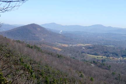
ALL DAY No. A0604-397 Nov. 26 Bad Fork – Chestnut Cove Overlook 8:30 AM* (moderate) Hike 9.5, Drive 5, 950 ft. ascent, Rated A-C Stuart English, 828-883-2447, stuengo@citcom.net P400 Note later start time. This is an in-and-out hike, beginning at the Trace Ridge trailhead. We will hike up Bad Fork to the BRP (a steep 700 ft. ascent for the second mile). At Bent Creek Gap, we will follow the MST to the Chestnut Cove Overlook, enjoy a beautiful view during lunch, then return to the parking area. *Meet at Westgate at 8:30 AM to form carpools, and meet leader at Trace Ridge parking lot at 9:00 AM. Topo: Dunsmore Mtn; also Nat’l. Geo. PRD map, and MST Profiles, pgs. 55-56
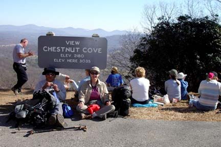
Fifteen hikers showed up for a great hike on a beautiful day. From
the Trace Ridge Trail Head in North Mills River, we took an unmapped, but
marked trail following a stream through campsites to the Bad Fork Trail
Head. From there we made a gradual (except for about a third of a mile)
ascent to the BRP.Then we followed the MST two miles to Chestnut Cove
Overlook for lunch. From there we enjoyed a view of the Avery's Creek area
and in the distance, Arden. On the way back we heard the strange call of a
bird (?) or something that no one could identify. Where are you when we need
you, Tom Bindrim? Everyone agreed that this was a great way to work off
Thanksgiving excesses. Three people from South Carolina came up for the
hike; Laura and Corinne from Charleston, and our old friend and fellow
member from Aiken, Irene. Stuart. Photos - left, Stuart English, right, Ashok Kudva
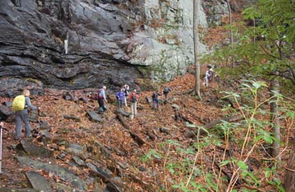
ALL DAY No. A0604-537 Dec. 3 Pinnacle Pass – Rim of the Gap –Coggins Loop 8:00 AM* (strenuous) Hike 10, Drive 110, 2000 ft. ascent, Rated A-A Matt Sowles, 864-855-6861, sowleman@charter.net From the Caesar’s Head Visitor Center, we’ll do a loop hike in the Mountain Bridge Wilderness Area. We’ll start with the Naturaland and Pinnacle Pass Trails, then cut over to the Rim of the Gap Trail and follow it to the Frank Coggins Trail back to our cars. If the weather is cold, there may be ice on the Rim of the Gap Trail. *Meet at Westgate at 8:00 AM to form carpools, and meet leader at Caesar’s Head Visitor Center parking lot at 9:00 AM. Make stop at Bi-Lo in Pisgah Forest at 8:30 AM for additional hikers. Topos: Cleveland, Table Rock; also Mountain Bridge Wilderness Area Trail Map
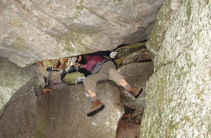
Twelve hikers (including one non club member) met at Caesar's Head State Park for this hike, a new one for the CMC. After some consternation from the first-time hike leader about a nonmember showing up to this strenuous hike with new boots, the hike got under way. The first stretch was a 1/4 mile road walk down US 276 to the Naturaland Trust Trail. After leaving the road and descending along the trail, the hikers were immediately rewarded with a beautiful cascade of water from the top of the ridge above them. Soon after, the hikers reached the Pinnacle Pass trail and continued descending along it. Before meeting the point where Pinnacle Pass trail intersects US 276, a great view of the eastern face of Table Rock was enjoyed by all.
The hike continued on the Pinnacle Pass trail, at this point an old jeep track. At midmorning, our party stopped for a snack alongside Oil Camp Creek. Within 300 yards of resuming hiking after snacks, we passed a nice waterfall, Oil Camp Creek Falls. About half the hikers descended to the creek bed level from the jeep track roadbed to get a closer look and snap some photographs. Everyone agreed that this is the logical snack spot for next time this hike is offered.
So far, the hike had been a constant descent, much more in line with an easy hike rather than a strenuous. That changed quickly as the trail ascended 1500 feet to the rock bluffs above Oil Camp Creek. Hikers quickly shed clothing as the ascent got everyone's heart rate going. Along the way, the group stopped to marvel at what appeared to be aloe yucca plants growing on this south facing mountainside. Hiking continued with some navigation of blown down trees and plenty of uphill.
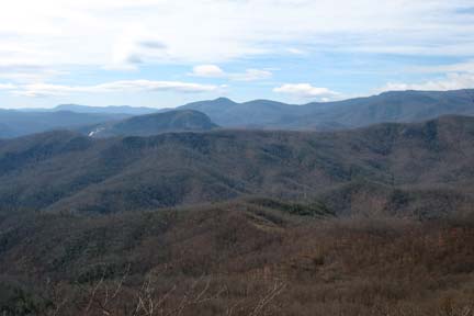
After lunch at a spectacular rock bluff overlook of the South Carolina upstate, the hike continued along Pinnacle Pass, John Sloan, and the very aptly named Rim of the Gap Trail. For many hikers, this was their first time navigating this stretch of the Rim of the Gap trail. Many "ooh's", "ahh's", and even one "awesome!" were heard as the group traversed its way over and amongst numerous waterfalls/water-crossings and sheer rock faces. The constant roaring of the Middle Saluda river could be heard down below in Jones Gap, and a grand view of the northern side of the gap made the hike all that more memorable.
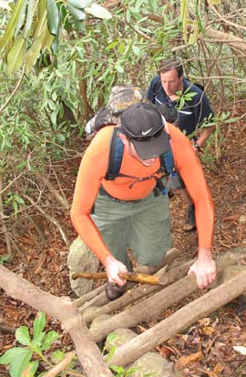
After a semi-emergency involving the temporary loss of the sweep and one hiker
near the end of the Rim of the Gap trail, the hike ended with a nice gentle
uphill climb back to the parking lot at Caesar's Head via the Frank Coggins
Trail.All souls made it back to the parking lot safely with no reported major
blisters/bumps/bruises/etc. The non-club member (a young woman named
Franchesca, Italian by birth, lately of Durham, NC) surprised us all by
maintaining the pace, all in brand new boots! Total ascent turned out to be
2800 ft. Owing to that and the effort required to traverse the Rim of the Gap
trail, this hike will probably be classified as A-AA or AA-AA next go round. Many thanks to everyone who participated in this great hike.
"Climb the mountains and get their good tidings. Nature's peace will flow into
you as sunshine flows into trees. The winds will blow their own freshness into
you, and the storms their energy, while cares will drop away from you like the
leaves of Autumn." - John Muir ...
Matt ... Photos by Danny Bernstein Left picture, "Whose legs are those?" Right picture, "Matt our fearless leader in the orange shirt".
ALL DAY No. A0604-538 Dec. 3 Vineyard Gap – Forge Mtn. Loop 9:00 AM (moderate) Hike 7, Drive 55, 800 ft. ascent, Rated B-C Ruth Hartzler, 828-251-0886, ruthmtn@charter.net P400 Note later start time. This is a nice loop hike from the Turkey Pen parking area, a walk along the Forge Mtn. ridge, a pleasant stroll along the S. Mills River, ending with a short, steep climb up to the parking area. Second meeting place: Turkey Pen parking area at 9:30 AM. Topo: Pisgah Forest; also Nat’l. Geo. PRD map
Eight hikers had the best weather for this hike, not too cold, but brisk, clouds mixed with sunshine and blue sky. We traveled from the Turkey Pen parking area up the Vineyard Gap Trail to Vineyard Gap. From there, we followed a faint, unmarked trail along Forge Mountain ridge until turning back at private property. We had lunch on the ridge accompanied by discussions on various subjects, including the growing impact of development on our beloved mountains. We retraced our steps back to Vineyard Gap, and then continued steeply down to the South Fork of the Mills River. We followed the Riverside Trail stopping to enjoy views of the river swollen with recent rains. We climbed an unmarked trail that took us steeply back up and over the ridge to our cars. Sometime during the day, one long-time CMC member remarked to the two new hikers that this hike was exceptionally quiet. Usually, there is more conversation. I took advantage of the quiet to appreciate the cloud formations against the varying shades of blue sky, the patterns of brown and gray tree trunks, and sparkling water rushing over huge river rocks. -- Ruth
November 26: No hike leader available, have a Happy Thanksgiving!
HALF DAY No. H0604-344 Dec. 3 Pulliam Creek in the Green River Game Lands 12:30 PM*Hike 6.5, Drive 60, 1000 ft. Ascent, Rated B-B
Nonmembers, call leader, Rusty Breeding, 828-692-0359, bree_lw@yahoo.com
*Note early start time. This pretty in-and-out hike goes along Pulliam Creek for part of the way. We may see kayakers on the Green River. Join leader for dinner at Cracker Barrel after the hike. *Meet at Westgate at 12:30 PM to form carpools and meet hike leader at NW corner of parking lot of Cracker Barrel off Exit 53 of I-26 at 1:00 PM.
There was a high overcast and filtered sun, temperature about 53--a good day for a hike.
Two carloads had no parking problem at the Pulliam Creek
Trail roadside pull-off. We had an unfortunate
incident when one hiker slipped on the creek crossing
and the sole came off his boot. He went back to keep
warm in a car while the rest of us went on to the
Green River Trail junction. We cut the hike short and
did not go down to the river. Another hour would have
gotten us back to the cars with only twenty minutes to
spare before sunset. This is the best time of year to
get a bird's eye view of the Green River Narrows from
Pulliam Creek Trail. But that will be another hike
another day. Rusty Breeding
 WEDNESDAY NO. NO. W0604-406 Nov 22 Pink Beds to Clawhammer Mtn 8:30 AM Hike 8, Drive 86, 2300 ft. ascent, Rated B-AA Charlie Ferguson, 828-398-0213,.ccf108@gmail.com
P400 The trailhead is at the Pink Beds parking lot (FS477). Climb on the Club Gap trail to Club Gap.
Then take the Black Mt. Trail along Rich Mtn., climbing through Buckhorm Gap and along the ridge to the overlook at Clawhammer which has great views. That will be our lunch stop. Then return the way we came. We will take our time while climbing. Second meeting place: Pisgah Ranger Station at 9:00 AM. Topo: Shining Rock; also Nat’l. Geo. PRD map
WEDNESDAY NO. NO. W0604-406 Nov 22 Pink Beds to Clawhammer Mtn 8:30 AM Hike 8, Drive 86, 2300 ft. ascent, Rated B-AA Charlie Ferguson, 828-398-0213,.ccf108@gmail.com
P400 The trailhead is at the Pink Beds parking lot (FS477). Climb on the Club Gap trail to Club Gap.
Then take the Black Mt. Trail along Rich Mtn., climbing through Buckhorm Gap and along the ridge to the overlook at Clawhammer which has great views. That will be our lunch stop. Then return the way we came. We will take our time while climbing. Second meeting place: Pisgah Ranger Station at 9:00 AM. Topo: Shining Rock; also Nat’l. Geo. PRD map
Nine hikers started our hike in light drizzle on a few short roads in
the Cradle of Forestry to get to the Club Gap Trailhead. Most of us put
on rain gear in order to forestall the development of more rain. Sure
enough, part way up the Club Gap trail the drizzle stopped. The wet
leaves on the rocky trail were less slippery that the scout of the hike
a few weeks before. The 700 foot climb to Rich Mountain encouraged the
shedding of a layer or so of warmth. We hiked down along the ridge line
to the junction with the Barnett Branch trail and considered it as a
possible route back to the Pink Beds parking lot. Continuing on the
ridge line toward Soapstone Ridge, we acquired another hiker who wanted
to join us. She refused to sign the sign up sheet but we decided to let
her hike anyhow. She had four legs and the orange collar told us that
she was someone's lost hunting dog. We made a couple of calls to her
phone numbers and left messages. She looked healthy but had lost a lot
of weight. She followed even though we didn't feed her. As we proceeded
along the ridge to the Buckhorn Gap Shelter the wind started to pick
up. Down to Buckhorn Gap and the wind got stronger. Finally - a 600
foot climb up to the top of Clawhammer Mountain. The wind was strong
there and we wanted to get out of the wind for lunch. We hiked down to
the saddle between Clawhammer and Black Mountain. There was a flat rock
outcrop with a spectacular view of the mountains to the west. There was
no wind. The sun came out. It was warm. Nature served us a perfect
lunch spot. A few hikers had a little extra food for our four legged hiker.
We returned the way that we came. The extra 2 miles of flat hiking in
the Pink Beds would have added another hour to the hike. The sky was
mostly sunny all the way back. When we arrived back at the parking lot
one of the hikers volunteered to take the dog to the ranger station.
The ranger there gave the dog a water dish and put him on a leash. On
the way back to Westgate some of us took the parkway. I talked to the
dogs owner and directed him to the Ranger station. He said that he had
been looking for the dog for a week. As we approached Asheville on the
parkway we saw a big bright rainbow to the east. Everyone agreed that
this was a great hike. Charlie Ferguson ... Photo by Danny Bernstein
WEDNESDAY NO. NO. W0604-519 Nov 29 Raven Cliff Falls, Cathedral Rock, Dismal Trail Loop 8:00 AM Hike 9, Drive 95 2300 ft. ascent, Rated A-AA Ann Gleason, 828-859-9387, gleason.ann@gmail.com Hike to 412 ft. Raven Cliff falls in Caesar’s Head State Park where we cross the suspension bridge and descend 120 ft. down “the Cathedral.” We Then cross Matthews Creek on a cable crossing and ascend steeply up the Dismal Trail to a large rock outcropping with a great view of the falls and then return to parking lot. Second meeting place: Bi-lo parking lot in Pisgah Forest at 8:30 AM. Additional meeting place: Raven Cliff parking lot on US 275 at 9:00 AM. Note there is a $2 fee per person for park entry. Topo: Table Rock: also Mountain Bridge Wilderness map
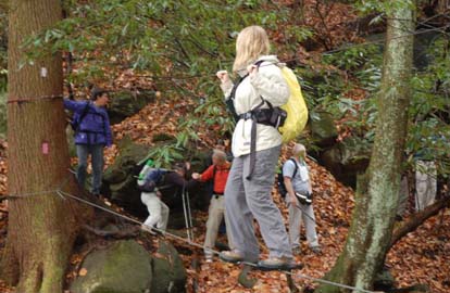
We had 13 hikers show up for the hike despite the passing showers and varying densities of fog.
Rain and drizzle occurred in sporatic bursts and passed just as quickly all day.
The day was also in the low 60's and seemed very warm. We didn't get to enjoy any views down the valley
or of Raven Cliff Falls but the drama of the cable crossing over Matthews Creek at the bottom of the Dismal, and the cliff hike up The Cathedral was an especially beautiful section of the hike. We started out on the trail by 9:25 am and were back at the cars at 3:10. Ann. ... Photos by Ted Connors
All-day hikes submitted by Bruce Bente 692-0116, bbente@cytechusa.com . Driving distance is round-trip from Asheville. All Saturday and Sunday hikes assemble at Westgate Shopping Center near I-240 UNLESS OTHERWISE NOTED.
Half Day hikes submitted by Paula Robbins 828-687-1651 paularww@bellsouth.net.
Wednesday Hikes are submitted by Charlie Ferguson, 828-398-0213 ccferguson@email.com and Ann Gleason, 828-859-9387, cowbonetail@yahoo.com .
The meeting place for each hike will be designated by the hike leader and will appear in the hike description.
Driving mileage will be listed, round trip, from the first designated meeting place.
Leaders: Mail please mail your sign-up sheets. Meet at Westgate unless otherwise noted.