 CMC Bi-Weekly Hike News
CMC Bi-Weekly Hike News
March 14, 2007
| All Day Saturday and Sunday Hikes |
| Half Day Sunday Hikes |
| Wednesday Hikes |
Looking Back ... with hike reports
| All Day Saturday and Sunday Hikes |
| Half Day Sunday Hikes |
| Wednesday Hikes |
|
ALL DAY No. A0701-532 Mar. 18 Sassafras Mtn. 8:30 AM* Hike 9, Drive 140, 2400 ft. ascent, Rated A-AA Lenny Bernstein, 828-236-0192, lsberns@worldnet.att.net *Note later start time. This is a pleasant hike from US 178 up to the highest peak in South Carolina, following the Foothills Trail. Early spring flowers and possible winter views on top. Second meeting place: NE corner of Cracker Barrel parking lot at exit 53 of I-26 at 9:00 AM. Topo: Eastatoe Gap; also Guide to Foothills Trail, sections A4 to A2. SATURDAY No. A0701-093 Mar. 24 Graybeard Mountain 8:00 AM* Hike 10-11, Drive 35, 2700 ft. ascent, Rated A-AA Steve Pierce, 828-724-4999, stevepierce@charter.net An exciting ridgetop manway along the middle mountain is our path to the summit. Return to Montreat via Walker Knob and Pot Cove Gap. There’ll be good views, a delightful hike and a good workout. Fairly strenuous, including a very steep first mile. *Meeting places: Meet at Westgate at 8:00 AM to form carpools, and meet leader at parking lot adjacent to McDonalds at exit 64 of I 40 at 8:20 AM. Topo: Montreat; also Montreat Trails Map ALL DAY No. A0701-551 Mar. 25 Fish Hatchery to Davidson Campground via Cat Gap 8:00 AM* Hike 10, Drive 72, 2050 ft. ascent, Rated A-AA Joan Lemire, 828-231-9259, tjbindire@yahoo.com P400 *Meet at Westgate at 8:00 AM to form carpools, and meet leader at Pisgah Ranger Station at 8:40 AM. This will be a moderately-paced hike via Cat Gap and the Art Loeb Trail, with lunch atop Chestnut Knob. The trail is NOT all downhill thereafter. Car shuttle. Topos: Shining Rock, Pisgah Forest; also Natl. Geo. PRD map HALF-DAY No. H0701-344 Mar. 18 HALF-DAY NO. H0701-196 Mar. 25
Vineyard Gap Loop 1:30 PM* WEDNESDAY No.W0701-344 Mar. 14 Pulliam Creek in the Green River Gamelands 9:00 AM Hike 6.5, Drive 60, 1000 ft. ascent, Rated C-B Becky Elston, 828-749-1886, belston@cytechusa.com This pretty in-and-out hike goes along Pulliam Creek for part of the way. We may see kayakers on the Green River. Second meeting place: NE corner of parking lot of Cracker Barrel off Exit 53 of I-26 at 9:30 PM. Topo: Cliffield Mtn; also Trails of the Green River Game lands map WEDNESDAY No.W0701-344 Mar. 14 Pulliam Creek in the Green River Gamelands 9:00 AM Hike 6.5, Drive 60, 1000 ft. ascent, Rated C-B Becky Elston, 828-749-1886, belston@cytechusa.com This pretty in-and-out hike goes along Pulliam Creek for part of the way. We may see kayakers on the Green River. Second meeting place: NE corner of parking lot of Cracker Barrel off Exit 53 of I-26 at 9:30 PM. Topo: Cliffield Mtn; also Trails of the Green River Game lands map WEDNESDAY No. W0701-049 Mar. 21 Big Creek - Walnut Bottom 8:00 AM Hike 6 or 11, Drive 110, 1500 ft. ascent, Rated A-B Ashok Kudva, 828-698-7119, ashok.kudva@mchsi.com 900M Follow the sight and sound of a spectacular mountain stream through a beautiful forest to Walnut Bottom. Features to be seen on this hike on a wide roadbed are the Midnight Hole, Mouse Creek Falls and several rapids. A shorter hike will be offered if a minimum of 3 people wish to do it. Second meeting place: Pilot Truck Stop, off I-40 at Exit 24 at 8:30 AM, but call leader first. Topo: Luftee Knob, Cove Creek Gap; also Nat'l. Geo. GSMNP Map ALL DAY No.A0701-056 Mar. 4 Black Mountain Ramble 8:00 AM (strenuous) Hike 9.4, Drive 60, 2600 ft. ascent, Rated A-AA Becky Smucker, 828-298-5013, bsmucker@charter.net P400 This great winter hike starts at Turkey Pen parking area, then over Sharpy Mtn. and around Black Mtn., ending at the Pisgah Maintenance parking lot. A long uphill, but with good views from our lunch spot at Black Mtn. Second Meeting place: Intersection of NC 280 and Turkey Pen Rd. at 8:30 AM. Car shuttle. Topo: Pisgah Forest; also Nat’l. Geographic PRD map
With a late Saturday forecast of cold but sunny for Sunday, we were pretty surprised to wake up to full overcast and blowing snow. That didn’t last, though, and we ended up with a beautiful brisk day, just like the forecast. Ten hikers made the trip from Turkey Pen across Sharpy’s Mountain, along the ridge, skirted Black Mountain, and then dropped down to 276 near the Ranger Station. It was an invigorating hike with nice winter views from the ridge line. Our group included four people from an hour or more away including three states, and we especially appreciated their making the effort to join us. We are recommending to Bruce that the name of this hike be changed to “Turkey Pen Roller Coaster”, since we spent most of the day doing steep ups and downs, and since that would avoid the confusion some people experienced with hikes in the vicinity of the town of Black Mountain. Thanks to all for a fun day! Becky Smucker. Photos by Lou Astle. ALL DAY. No.A0701-327 Mar. 4 Ridgecrest Ramble 9:00 AM (moderate) Hike 6-7, Drive 40, 1400 ft. ascent, Rated B-B Ruth Hartzler, 828-251-0886, ruthmthn@charter.net A good winter hike, following the Rattlesnake, Rhododendron and Adventure Trails. This moderate hike in the Ridgecrest area offers a number of great scenic overlooks as it meanders along the ridgelines, and includes Rattlesnake, Copperhead and Lookout Mtns. Second meeting place: Parking lot adjacent to McDonald’s at exit 64 of I 40 at 9:20 AM. Topo: Montreat
BACKPACK No. A0701-549 Mar. 10 - 11 Winter Backpack in the Smokies: Big Creek Loop. Hike 16.5, Drive 110. 3200 ft. ascent, Rated A-A Chip Miller, 828-654-9331, backpacker54nc@bellsouth.net This two-day, one-night backpack will start at the Big Creek trail head, for a 5.3 mile hike to backcountry campsite 37, with ascent of 1250 ft. Sunday we will ascend 1250 ft. on the Low Gap trail to reach the Appalachian Trail. From this junction we will hike to the Mt. Cammerer tower built back in the 1930's by the Civilian Conservation Corps. GREAT VIEWS!! (side trail, in & out). Back on the AT we will hike to the Chestnut Branch Trail and follow it back to the Big Creek Ranger Station. Sunday’s total miles will be 11.2 (5.4 headed downhill ). Limited to 8 participants experienced in winter backpacking. Space is limited, because backcountry campsite 37 is "Rationed"! Verify that you can attend before reserving a spot. For meeting place and time, call leader. Topos: Waterville, Hartford, also Nat'l Geo. GSMNP map. ALL DAY No. A0701-550 Mar. 11 Paris Mtn. State Park 8:30 AM* Hike 9.9, Drive 130, 2000 ft. ascent, Rated A-A Danny Bernstein, 828-236-0192, danny@hikertohiker.org *Note change to Daylight Savings time today. Located between Traveler’s Rest and Greenville, Paris Mountain State Park is one of the oldest protected areas in South Carolina. Originally, the lakes were the source of Greenville’s water supply. We will walk on well-maintained trails, enjoying good winter views, early spring flowers and warmer weather than in Asheville. Second meeting place: NE corner of Cracker Barrel parking lot at exit 53 of I-26 at 9:00 AM. Topo: Paris Mtn.  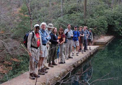 They came from Westgate, Cracker Barrel and the entrance to Paris Mountain State Park, curious to see this South Carolina Park. The hike started out toward an artificial lake, crossed several streams and reached a second parking lot. By that time, mountain bikers had woken up and we had to give them way. We had lunch at North Lake, a very pleasant scene. Kathleen, Michael, Charlie and others decided to investigate the lake and found huge frogs, some intent in propagating their species. Michael wanted to check out the temperature of the water, which turned out to be a mistake. Soon, he broke out in welts but that didn't slow him down much. We climbed up Brissy Ridge Trail and found ourselves back at the second parking lot, with a lot of people starting out for a walk. We decided that this hike should be done again but not on a Sunday. Saturdays might be good, since bikes are not allowed on the trail then. Wednesdays may also have fewer bikers. On the positive side, the trails were well maintained and the hike attracted South Carolina members. Danny. Photo on left by Charlie Ferguson, on right by Ted Connors.. They came from Westgate, Cracker Barrel and the entrance to Paris Mountain State Park, curious to see this South Carolina Park. The hike started out toward an artificial lake, crossed several streams and reached a second parking lot. By that time, mountain bikers had woken up and we had to give them way. We had lunch at North Lake, a very pleasant scene. Kathleen, Michael, Charlie and others decided to investigate the lake and found huge frogs, some intent in propagating their species. Michael wanted to check out the temperature of the water, which turned out to be a mistake. Soon, he broke out in welts but that didn't slow him down much. We climbed up Brissy Ridge Trail and found ourselves back at the second parking lot, with a lot of people starting out for a walk. We decided that this hike should be done again but not on a Sunday. Saturdays might be good, since bikes are not allowed on the trail then. Wednesdays may also have fewer bikers. On the positive side, the trails were well maintained and the hike attracted South Carolina members. Danny. Photo on left by Charlie Ferguson, on right by Ted Connors..
HALF-DAY NO. H0701-553 Mar. 4 Montreat Loop #4 1:00 PM The air was cold and clear but the morning’s dusting of snow had melted
by the time eight of us, including one visitor, gathered at Montreat.
The clear air made for stunning views of the snow still on the Blacks
and Craggies from our first stop atop Lookout Rock and of the Blue Ridge
as we continued along the East Ridge Trail. For six of our number this
was their first hike along the East Ridge Trail and a pleasant
introduction to the trails of Montreat. Joe Burchfield HALF-DAY No. H0701-498 Mar. 11 High Windy 12:30 PM* 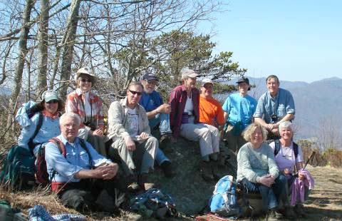 A group of 13 congregated in Black Mountain on a sunny spring afternoon, happy to defy the forecast for rain. Hike leader Renate Rikkers gave a brief historic overview of the Blue Ridge Assembly which was established in 1906 as a national YMCA Conference and Leadership Center. The Assembly owns (and protects from development) 2500 acres of beautiful mountain land with many miles of hiking trails for the over 30,000 guests who visit there each year. Director Roger Hubbard invites the CMC to continue hiking these trails despite a general policy change discouraging outside use of their property. Since scouting the trails about 6 weeks ago, a lot has happened. The Cliffs development (which now reaches from Swannanoa into Fairview, covering 2500 acres) abuts the Assembly property on the Fairview side. We were brought to a hushed standstill by the property flags along our trail as we came to higher elevations where we were confronted by looking at the recent Cliffs "preparations" of their latest development which promises well over 500 single house lots on the Fairview side. This is a good example of old land preservation values clashing with new development ideas, and it certainly put a damper on our happy hike! We enjoyed taking it easy on the steep 2 1/2 hour hike up to High Windy, covering over 1700' of elevation along the way. This congenial group found plenty of topics to talk about and connected several guest hikers with very new members and old members. One new member, Hank Young, deserves a gold star on his chest for collecting two large bags of trash, mostly beer cans and bottles, at the top of High Windy, and carrying it all the way down, then driving to a recycling station to get rid of it! Everyone returned to their cars in high spirits and appreciation of the combination of great weather, a really nice hike, and a great group of folks to share it with. The total hike time was 4 hours - just right! Renate Rikkers, Hike Leader A group of 13 congregated in Black Mountain on a sunny spring afternoon, happy to defy the forecast for rain. Hike leader Renate Rikkers gave a brief historic overview of the Blue Ridge Assembly which was established in 1906 as a national YMCA Conference and Leadership Center. The Assembly owns (and protects from development) 2500 acres of beautiful mountain land with many miles of hiking trails for the over 30,000 guests who visit there each year. Director Roger Hubbard invites the CMC to continue hiking these trails despite a general policy change discouraging outside use of their property. Since scouting the trails about 6 weeks ago, a lot has happened. The Cliffs development (which now reaches from Swannanoa into Fairview, covering 2500 acres) abuts the Assembly property on the Fairview side. We were brought to a hushed standstill by the property flags along our trail as we came to higher elevations where we were confronted by looking at the recent Cliffs "preparations" of their latest development which promises well over 500 single house lots on the Fairview side. This is a good example of old land preservation values clashing with new development ideas, and it certainly put a damper on our happy hike! We enjoyed taking it easy on the steep 2 1/2 hour hike up to High Windy, covering over 1700' of elevation along the way. This congenial group found plenty of topics to talk about and connected several guest hikers with very new members and old members. One new member, Hank Young, deserves a gold star on his chest for collecting two large bags of trash, mostly beer cans and bottles, at the top of High Windy, and carrying it all the way down, then driving to a recycling station to get rid of it! Everyone returned to their cars in high spirits and appreciation of the combination of great weather, a really nice hike, and a great group of folks to share it with. The total hike time was 4 hours - just right! Renate Rikkers, Hike LeaderWEDNESDAY No. W 0701-308 Feb. 28 Ox Creek - Rich Knob 8:00 AM Hike 8, Drive 20, 1850 ft. ascent, Rated B-A Don Walton, 828-654-9904, donwalton@bellsouth.net . From Ox Creek Rd. climb to Rich Knob on the MST via Rattlesnake Lodge. Topo: Craggy Pinnacle Eleven hikers left Ox Creek East bound on the MST but not before Jerry McNabb took a picture of the group to be used for a higher purpose. We stopped at Rattlesnake Lodge to comment on the educational interpretation sign that the CMC paid for with funds from the Alan Barton Memorial Fund. It is always fun to mention that that our own longest member Bernard Elias’s mother is in the 1916 picture on the sign of the ladies playing bridge at the lodge. We arrived at Rich Knob early for lunch and gazed at the unusual view of Riceville and Swannanoa. We returned via the blue blaze Rattlesnake Lodge water reservoir trail to arrive early back at the cars. It was one of the most beautiful warm winter days on the trail this year thanks to global warming. Don. WEDNESDAY No. W0701-545 Mar. 7 Bent Creek #11 - Boundary Trail 8:30 AM Hike 8.5, Drive 25, 1300 ft. ascent, Rated B-B Stuart English, 828-883-2447, stuengo@citcom.net P400 From Bent Creek Gap we will follow the MST to the Bent Creek Boundary Trail, on to Ingles Field Gap, to Ledford Branch Road and down to Deer lake Lodge Trail and the Rice Pinnacle parking lot. Great winter views. Car shuttle. Second meeting place: Ingles parking lot, across from Biltmore Square Mall on NC 191 at 8:45 AM. Topos: Dunsmore Mt., Skyland; also Nat’l. Geo. PRD map and Bent Creek Trail map
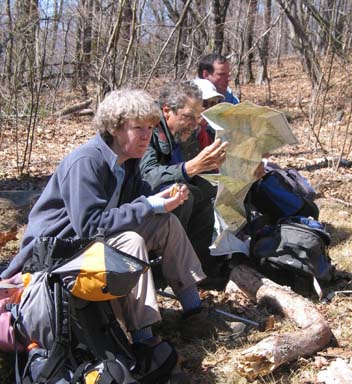
All-day hikes submitted by Bruce Bente 692-0116, bbente@bellsouth.net . Driving distance is round-trip from Asheville. All Saturday and Sunday hikes assemble at Westgate Shopping Center near I-240 UNLESS OTHERWISE NOTED. Half Day hikes submitted by Paula Robbins 828-687-1651 paularww@bellsouth.net. Wednesday Hikes are submitted by Charlie Ferguson, 828-398-0213 ccf108@gmail.com and Ann Gleason, 828-859-9387, gleason.ann@gmail.com . The meeting place for each hike will be designated by the hike leader and will appear in the hike description.
Driving mileage will be listed, round trip, from the first designated meeting place. |
|
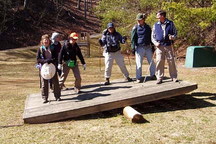 I checked the forecast every day for a week and it was always the same… partly cloudy, 10% chance of precipitation with high temperature in the low 40’s. This would be perfect for a hike where views from four different lookouts are the main attractions. When I looked out the window on hike morning, I couldn’t believe there was snow on the ground and it was snowing! So, I skidded down Town Mountain Road to Westgate confident that Bruce and Ashok would be there. The roads were clear, but it was cold (24 degrees), windy and overcast. So, the three of us piled into my car for the ride to Black Mountain. On the way, we decided we would stop for coffee and wait for the warmer temperatures, if no one was waiting in Black Mountain. By the time we arrived in Black Mountain, the sun was shining and four additional hikers were ready to hike. We did the same route as Wednesday, Feb. 21. I was going to write, that we did the same hike. But, hikes are never the same. We enjoyed the spectacular views at Rattlesnake, Copperhead, Look Out, and Royal Gorges. But no one proposed marriage. By the end of the hike, everyone was feeling good and having fun. The conversation turned to squirrels that can water ski, and dogs that can surfboard. We couldn’t resist the large see-saw (see photo . This is a really good winter hike in clear weather. – Ruth, photos by Bruce.
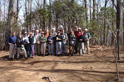 Twenty-three hikers showed up on partly cloudy, soon to be warm and sunny Wednesday.
Once the car shuttle was organized (with help from veteran hike leaders) and
the hike leader's nerves settled, it turned into a very nice hike. We
followed the MST from Bent Creek Gap to the old, unmaintained Boundary
Trail, to the maintained Boundary Trail, to Ingles Field Gap, and gradually
down into the Bent Creek Basin and our cars at the Rice Pinnacle parking
lot. On the boundary trail near Ingles Field Gap is an old wall with a guard
rail, suggesting that this once was a serious motor road. The signs of this
road go to Yellow Gap, where the trail is no longer maintained, and end
there. A mystery. Some mountain bikers were encountered, but there was never
a problem. Everyone seemed to have a good time, including the leader. Stuart
Twenty-three hikers showed up on partly cloudy, soon to be warm and sunny Wednesday.
Once the car shuttle was organized (with help from veteran hike leaders) and
the hike leader's nerves settled, it turned into a very nice hike. We
followed the MST from Bent Creek Gap to the old, unmaintained Boundary
Trail, to the maintained Boundary Trail, to Ingles Field Gap, and gradually
down into the Bent Creek Basin and our cars at the Rice Pinnacle parking
lot. On the boundary trail near Ingles Field Gap is an old wall with a guard
rail, suggesting that this once was a serious motor road. The signs of this
road go to Yellow Gap, where the trail is no longer maintained, and end
there. A mystery. Some mountain bikers were encountered, but there was never
a problem. Everyone seemed to have a good time, including the leader. Stuart