CMC Bi-Weekly Hike Reports
March 20th, 2009 -- Looking Back
| All Day Saturday and Sunday Hikes |
| Half Day Sunday Hikes |
| Wednesday Hikes |
All Day Saturday & Sunday ALL DAY NO. A0901-332 March 8
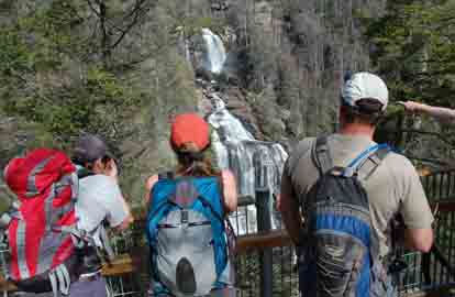
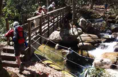
Photos by Ted Connors and Bruce Bente Twenty-two strong hikers met at Westgate and the Pisgah Forest Bi-Lo. We began on the Foothills Trail, and after a short spur trail up to an overlook to view Whitewater Falls from about 300 meters away we began the 325-foot descent to the Whitewater River. An easy 1.9 mile walk on well maintained trails alongside the Whitewater River took us to a trail junction. There we went left, continuing on the Foothills trail for about two miles to the Thompson River where we had a leisurely lunch at the bridge. We returned the way we came, starting with a longish steep uphill until we got to the side trail that went left to the Lower Whitewater Falls overlook. This was a fairly easy 1.9 mile in and out from the Foothills Trail. Like the Upper Falls, this overlook gave a long distance view of the Falls. Returning to the junction near the Whitewater River, we had two more steel foot bridges and a 0.7 mile flat hike to our cars. After the hike seventeen very hungry hikers went to Brevard and ate at Ed Boudreaux's. I think this is a record for a CMC post hike supper. This was a great hike with wonderful hikers on it. The trails were all in good condition with a variety of scenery and forest types to walk through. The total ascent was about 2400 feet, 800 feet more than the original description.--Charlie Ferguson SATURDAY NO. A0901-256 March 14
Photos by Jan Onan Nine hikers turned up for the Moore Cove Figure 8 hike on a wet Saturday morning, including two almost 15 year olds! We started the hike at 11:15 and ended 4 hours later. “Red” Ted volunteered to serve as our sweep. ALL DAY NO. A0901-056 March 15 The hike was canceled due to heavy rain.--Michael Cornn HALF-DAY NO. H0901-485 Mar. 8 HALF-DAY NO. H0901-639 Mar. 15
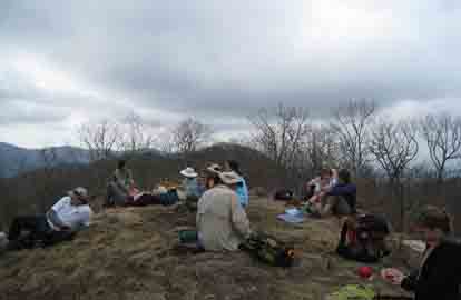
Photos by Bruce Bente Sunday the 15th dawned dark, gloomy and rainy, enough so that the all-day hike was cancelled. But by noontime, the rain stopped and it appeared that the afternoon hike would be possible. Sure enough, ten hikers showed up for the hike, although not the ones expected…most of the ten were all-day hikers (including the leaders of the cancelled all-day hike!), and only a few half-day hikers came to enjoy an interesting hike. We proceeded up a private gated road (permission having been generously granted by the owner of Green River Preserve), forded a creek and parked. Our hike went up an old forest road to the NC-SC border, where we walked the old CCC Rd. along the ridgeline to Pretty Place for the “view”. The clouds and fog hung heavy, but cleared enough for a few interesting photos. We could readily see the burnt ground and low bushes from the fire a few weeks ago, and see the bulldozer tracks where it cleared a fire break in the woods. The fire actually came up to within 100 ft. of the structure itself, but no damage occurred. A pleasant hike and no rain! --submitted by Bruce Bente All Day Wednesday WEDNESDAY NO. W0901-560 Mar. 4 The scheduled Wednesday hike was cancelled due to road conditions on secondary roads leading to the trail head. Instead we did an alternate hike: Bent Creek Loop Shut In Trail to Sleepy Gap to Lake Powhatan by several trails. The hike was a group effort and thanks go to Bob Hysko, who had led the hike before, and Ken Schroeder, who knew it well for their help. In fact most of the people on the hike probably knew the hike better than the leader. I think you call that irony. But it was beautiful, but chilly day as we climbed up the Shut In/MST. At one point we were walking in a foot of snow or more. It made us wonder how much we would have found on Rube Rock. The Sleepy Gap Trail was not quite as treacherous as we expected and we made it to Lake Powahatan without incident and ate our lunch on the picnic tables. We then strolled back to our cars at Sandy Bottoms parking lot, (we couln't even get to French Broad Overlook) by 2PM. This is the hike leader's fault. He should have dawdled more.--Stuart English
WEDNESDAY NO. W0901-076 Mar. 11
Photo by Don Walton Fourteen hikers ignored the 20% chance of rain to make the trek out to Snowball Tower Site to look at the views. The Blacks were clouded in so we could not identify the peaks with great accuracy but the general views from the tower site were grand. The CMC has been clearing the trees to bring back the views at the tower site. The views from Hawksbill (High Rocks) was also nice. One hiker tripped and incurred a small scrape on her cheek but will be fine. The round trip took 5 hours and we returned to Westgate at 3:30.--Don Walton WEDNESDAY NO. W0901-400 Mar. 18 Reports for Wednesday hikes during the eNews publication week will appear in the following eNew--The Editor.
All-day hikes submitted by Bruce Bente 692-0116, bbente@bellsouth.net . Driving distance is round-trip from Asheville. All Saturday and Sunday hikes assemble at Westgate Shopping Center near I-240 UNLESS OTHERWISE NOTED. Half Day hikes submitted by Lucy Prim 828-693-6580 lucette32@mchsi.com. Wednesday Hikes are submitted by Charlie Ferguson, 828-398-0213 ccf108@gmail.com and Ann Gleason, 828-859-9387, gleason.ann@gmail.com . The meeting place for each hike will be designated by the hike leader and will appear in the hike description.
Driving mileage will be listed, round trip, from the first designated meeting place. |