Store
Store Member Login
 Search



About the Hike
Hike Description
Contact leader by email for reservation. This is another of the P400 hikes that is scheduled during a summer month because of its fourteen stream crossings. This hike starts at the Gauging Station and ends at the Turkey Pen parking area. It is a long hike but except for two climbs it is entirely flat. Water shoes and hiking poles are recommended. Sturdy shoes are needed for the first 3 miles and the last half mile. Because it is a shuttle hike, I estimate being back in Asheville around 6pm. Topos: Pisgah Forest
Scout Report
Today i went to Turkey Pen to check out the water level. Being the furthest down the river it would give me an idea of the depth overall. It was shallow. So even with some spotty showers predicted we will be fine
- Hike Number
- 370
- Hike Leader
- Henry Kassell
- Hike Co-Leader
- N/A
- Canceled
- No
- Group
- All-Day Wednesday
- First Meeting Place
- Tanger Outlets parking lot behind Waffle House off Exit 33 of I-26 at 08:30 AM
- Second Meeting Place
- Pisgah Forest Walmart parking (back of center aisles close to Taco Bell) at 09:00 AM
- Rating
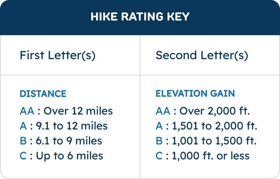
- A-B ?
- Total Elevation Gain (Feet)
- 1100
- Challenges
- Pisgah 400,Waterfalls (WC100)
- Drive Distance
- 75