Store
Store Member Login
 Search



About the Hike
Hike Description
Contact leader via email for reservation. Limit of 12 hikers. Form carpools and meet leader at second meeting place. On this variation of hike 611, we'll begin by hiking down the steep Staire Creek Trail from FS 63, then up the Walker Creek Trail and across the road to continue up on the Perkins Trail to the Laurel Gap Trail. After a 2-mile stroll on this meadow-like trail we'll head downhill on the Bear Pen Trail to return to our cars. These trails are rocky and steep in spots. There are several stream crossings on this hike. We walk near lovely creeks on some of the trails.Topos: Barnardsville
Scout Report
I scouted this hike on July 9 with friends Jim, Judy and David A. The parking area is small, maybe capacity for 5 vehicles. From here we could see Mountain Light Sanctuary on the other side of Walker Branch Creek. We also saw remains from a bridge that had been washed down the creek by Helene. This is a challenging hike, more so than I expected. For 3.25 miles we steadily climbed uphill on a trail with lots of rocks and washouts . This is where all of the elevation gain is on the hike. The next two miles, in contrast, are quite level. However, this Laurel Gap Trail is an old forest road that clearly has had no maintenance in a long time. A trail was visible, but we walked through overgrown plants that were wet from last night's rain and included nettles (stinging and wood), blackberry, monarda (bee balm) and blooming Turk's Cap Lily. It was very beautiful, and some were taller than I. There is no good open space along here to sit, so we stood for a quick snack break. Then the turn onto Bear Pen trail heads back down, at times very steeply. Close to the bottom I stepped on an old log, agitating yellow jackets, and was stung twice. Jim, who was right behind me, was stung four times. We saw evidence of recent landslides, probably from Helene. This is a good hike for adventurous people! It is shady almost the entire hike. Poles are highly recommended. Also consider pants to protect from stinging nettles and briers. There are several water crossings; most can be navigated via rock hops. But if you wear trail runners rather than boots, be prepared for wet feet as these crossings are not easy. I measured slightly over 8 miles and 1900' ascent. Also note that the last mile or so before we arrive at the trailhead is on a gravel road which has some potholes.
- Hike Number
- 611
- Hike Leader
- Marie Chamberlin
- Hike Co-Leader
- N/A
- Canceled
- Yes
- Group
- All-Day Wednesday
- First Meeting Place
- 160 Zillicoa St. (USFS parking lot) off Exit 25 of I-26 at 08:00 AM
- Second Meeting Place
- Publix at 165 Weaver Blvd. Weaverville lower end of parking lot off Exit 19 of I-26 at 08:15 AM
- Rating
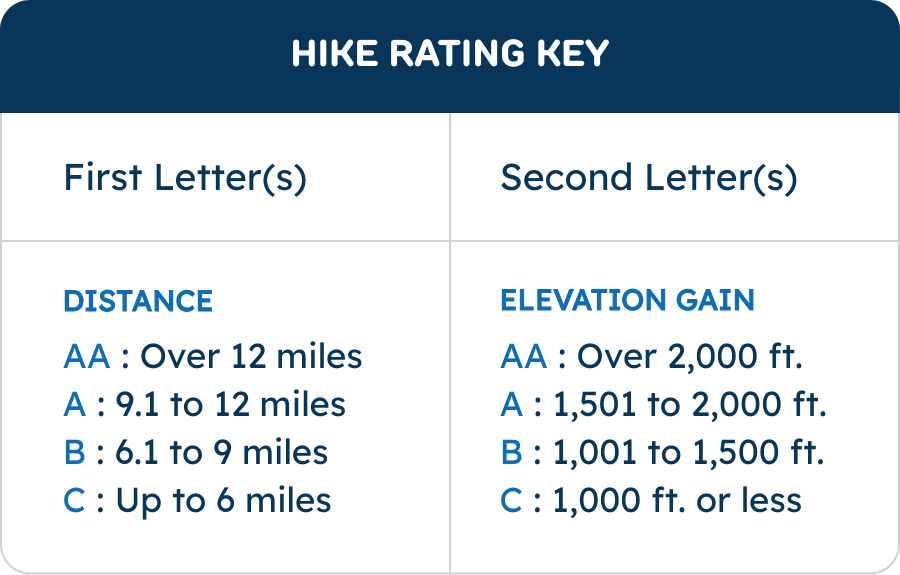
- B-A ?
- Total Elevation Gain (Feet)
- 1700
- Challenges
- N/A
- Drive Distance
- 35