All Day Saturday & Sunday
SATURDAY No. A0903-615 Sept. 19
Black Balsam Loop via Graveyard Ridge Trail & ALT 10:00 AM
Hike 6, drive 70, 1200 ft. ascent, Rated B-B
Marcia Bromberg, 828-505-0471, mwbromberg@yahoo.com
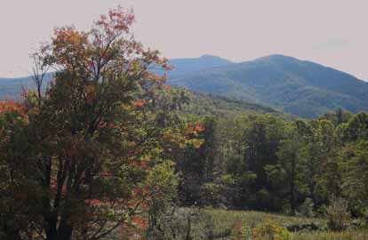
P400 Begin at FS 816, north on MST to Graveyard Ridge Trail. Left on Graveyard Ridge Trail to Ivestor Gap. Return on Art Loeb over Tennant and Black Balsam. We’ll stop at Ivestor Gap for possible late blueberries, and at the high points to enjoy great views! Second meeting place: Cold Mtn. Overlook (BRP M.P. 412) at 10:35 AM. Topos: Sam Knob, Shining Rock; also Nat’l. Geo. PRD map #780
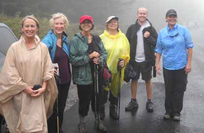
Photo by Marcia Bromberg
Six brave hikers including three sisters from out of town took the risk that the rain would hold long enough for us to complete the hike. I decided to reverse the direction of the hike, doing the Art Loeb section across Black Balsam and Tennent mountains just in case the rain came early. Luckily for us, the rain held off till the last section on the MST. By then we'd enjoyed the views and even picked blueberries. The picture was taken at the end of the hike.--Marcia Bromberg
ALL DAY NO. A0903-211 Sept. 20
MST: Pigeon Gap to NC 151 *8:00 AM
Hike 10.7 Drive 50, 1980 ft. ascent, Rated A-A
Stuart English, 828-883-2447, stuengo@citcom.net
P400 *Meet at Westgate at 8:00 AM to form carpools, and meet leader at Cold Mtn. Overlook (BRP M.P. 412) at 8:35 AM. We’ll hike the MST past the Pisgah Inn, over the top of Little Pisgah Mountain, and down to Elk Pasture Gap, enjoying mountain views along the way. Car shuttle. Topos: Shining Rock, Pisgah Forest; also Nat’l. Geo. PRD map #780 and MST Profiles, pg. 52-54
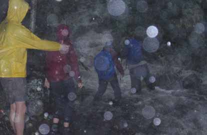 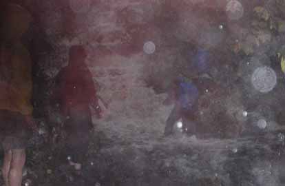
Photos by Carroll Keopplinger
Five crazy people showed up at Cold Mountain Overlook in the pouring rain and wanted to hike. I was willing to lead them, so I guess that made six. Three new hikers joined us: Lisa, Melissa, and Eric. So the demographics were split perfectly between them and the three of us Golden Passport carriers. It turned out to be an interesting hike. The many stream crossings on the Buck Springs Trail were both spectacular and challenging. Eric was great at positioning himself in the middle of the crossings and helping people across. We were knee deep in cold water at times and we couldn’t see where we were putting our feet because of the white water. When we got to the Pisgah Inn, we ate lunch on their back deck under the roof. The staff probably thought they were being invaded by homeless people. After lunch, it got colder and windier and continued to rain as we made our way over Little Pisgah and back to our car. We were glad to see the car. I have never gone on a hike that at the end I regretted walking. That still holds true.--Stuart English
SATURDAY NO. A0903-329 Sept. 26
Blackrock Mtn./Fisher Creek Trail *8:00 AM
Hike 10.8, Drive 96, 3000 ft. ascent, Rated A-AA+
Cindy McJunkin, 828-712-9646, mcjfive@aol.com
SB6K *Meet at Westgate at 8:00 am to form carpools, and meet leader at rest area on US 23/74 near Waynesville at 8:30 AM. This hike starts at the end of Fisher Creek Rd. east of Sylva and climbs to the summit of Blackrock Mtn. The trail, mostly old logging roads, is steep and rocky in places, but the views from Blackrock Mtn. are superb. Next we’ll go over Yellowface Mtn. and finish at the Waterrock Knob parking lot. Car shuttle. Topo: Sylva North
 
Photos by Cindy McJunkin
We started this hike wet and finished it wetter. Clyde Austin had driven five hours to hike, and three of us were determined to summit Blackrock and Yellowface. The trail begins at Fisher Creek in Sylva's Pinnacle Park. It climbs steeply to Blackrock, and we managed a dry lunch under Clyde's shelter. We enjoyed the mountain ash, goldenrod and green mosses as we continued the trail across Yellow Face and back to the visitor center--Cindy McJunkin
ALL DAY NO. A0903-074 Sept. 27
Tanawha Trail 8:00 AM*
Hike 13.3, Drive 150, 2600 ft. ascent, Rated AA-AA
Jim Reel, 828-738-0751, jimr57@yahoo.com
*Meet at Westgate at 8:00 AM, stop at second meeting place in Ingles parking lot adjacent to McDonald’s at Exit 64 of I-40 at 8:20 AM, and meet leader at Beacon Heights overlook at 9:30 AM. One of our best hikes when the weather cooperates. A fragile and ancient ecosystem, rhododendron and laurel tunnels, hardwood coves, boulder fields and great views make this a special hike. It will be a long day, consider an optional supper stop. Topos: Grandfather Mtn., Valle Crucis; also Nat’l. Geo. Cherokee NF map #783 and Linville Gorge map #779
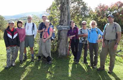 
Photos by Jim Reel and Paul Benson
On a beautiful, partly cloudy and windy morning ten hikers met at Beacon Heights Overlook on the Blue Ridge Parkway. The first part of the trail is seldom used and overgrown where it runs north along a thin strip of earth between the parkway and US 221 toward Stack Rock Overlook. For this reason, the leader decided to skip the first 9/10s of a mile and start at Stack Rock a little after 10:30 am. The trail was wet, muddy and slippery in places but no one complained because of the beauty of the early fall colors and the magnificent views. We had lunch at a rock outcropping well above the parkway and Linn Cove Viaduct and below the peaks of Grandfather Mountain. We admired those views as we identified the mountains to the east and enjoyed the CMC camaraderie. As we hiked north toward the Rough Ridge parking area we encountered a Park Service volunteer carrying a stuffed hawk perched on a stick. She gave us a short presentation about hawks in the area and answered a few questions, a nice surprise! The only excitement of the day was a false alarm for yellow jackets. We decided that a false alarm was a lot better than real yellow jackets. The only downside of the day was vehicle noise for most of the first 8 miles. Of course this made the last 4 miles seem even more peaceful. We finished the hike near Price Lake Campground at 5:30pm with a total distance of 12.2 miles with 2100 ft ascent and 2800 ft descent. Six of us had a great after hike meal at Spears in Linville Falls. Thanks to all who traveled the 150 mile round trip for the hike.--Jim Reel
SATURDAY NO. A0904-626 Oct. 3
FULL MOON HIKE *4:30 PM
Hike 2, Drive 75, 500 ft. Ascent, Rated C-C
*Meet at Westgate at 4:30 PM to set up carpool or drive to trailhead at FS 816 & MST. Everyone enjoyed this hike when CMC did it last year. We’ll do a self-directed hike this year (no leader). Everyone is invited to gather on the summit of 6215 ft. Black Balsam to see the moon rise in the east and the sun set in the west, and enjoy the great views and autumn colors. The nearly full moon will rise at 6:39 PM, and the sun will set at 7:12 PM, so come early enough to enjoy both. Bring a flashlight for the hike back to your car. If you need directions, phone Bruce Bente at 692-0116.
ALL DAY NO. A0904-082 Oct. 4
The Blacks Beyond 6000 *7:30 AM
(strenuous)
Hike 11.3, Drive 70-80, 3000 ft. (northbound) or 6000 ft. (southbound) ascent, Rated A-AA+
Don Gardner, 828-754-4067, gardog3@bellsouth.net (southbound) & Peter Barr, 704-941-9296, pjbarr@unc.edu (northbound)
SB6K, LTC *Note earlier starting time. Key-swap hike. This is your chance to bag seven SB6K peaks on this very strenuous hike. The southbound initial climb is 3100 ft., and there’s much more climbing in the ups and downs between peaks. North-bounders get to go down the 3100 ft. The hike is great fun with incomparable views, but do not consider this unless you are in top shape. Bring extra water. Participants must phone a leader beforehand. Second meeting place: Phone a leader. Topos: Celo, Mt. Mitchell; also PNF South Toe River, Mount Mitchell & Big Ivy Trail Map
A hearty group of 20 hikers took on the Death March southbound with another group of approximately 10 hikers going north. We all began on a cool morning at Westgate at 7:30 a.m. and with some difficulty coordinated the car and key swaps amongst 30 hikers. The southbound group began the hike at Bowlens Creek outside Burnsville with the other group commencing the hike at Mt. Mitchell.
The weather was just right--not too hot and not too cold. The skies were partly cloudy at the start and end the hike, but in were clear in between. A few of the trees were beginning to change colors but nothing very spectacular at this time.
All but one southbounder made it to Celo. From there south, the hike continued for the 6.5 grueling miles with a lot of ups and downs. Several sections of the trail have had ropes added on the steep ascents. The bushwhacks up Celo and Gibbs went with only a few scratches. We broke into several groups along the southbound route, as some hikers wanted to maintain a faster pace than others.
We had 6 hikers from the Greenville Hiking Club, another 5 non-CMC hikers from Lenoir, plus the gang from the Asheville area. Peter Barr met the northbound group at Mt. Mitchell after a trying ordeal that morning. He had spent the night in a fire tower (on purpose) but leaving his keys in the cab of the tower. Peter had hiked 7.5 miles that morning before starting the northbound hike at 9:30 a.m.
All in all a great day, a great hike, beautiful scenery and spectacular views. The Death March lived up to its name with some very sore legs and expanded lung capacity after it was all over.--Don Gardner
ALL DAY NO. A0904-667 Oct. 4
Pink Beds – Pisgah Inn *9:00 AM
(moderate)
Hike 8.2, Drive 85, 1700 ft. ascent, Rated B-A
Ashok Kudva, 828-698-7119, ashok.kudva@gmail.com
P400 *Note later starting time. Meet at Westgate at 9:00 AM to organize carpools for post-hike supper choice, and meet leader at Pisgah Convenience Store at 9:30 AM. From the left branch of the Pink Beds Loop we will take a short in and out on the Barnett Branch Boardwalk, recently built by CMC Friday Pisgah crew. We will proceed on the Barnett Branch trail, with a steep climb after we cross Yellow Gap Road, and pause at a waterfall. We’ll connect with the Buck Spring/MST Trail up to the Pisgah Inn. Optional post-hike dinner at the Pisgah Inn. Car shuttle. Topos: Shining Rock, Cruso; also NatGeo map #780
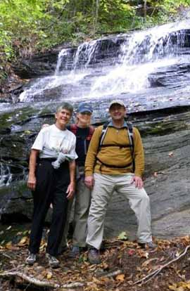
Photo by Ashok Kudva
Three new members joined me at the Pisgah Inn parking lot before 9:30AM. We waited 20 more minutes for hikers from Westgate, but no one showed up. The weather was gorgeous and the foliage was fairly colorful on the trail. The waterfall on the Barnett Branch trail was beautiful thanks to the recent rains. After climbing beyond the top of the falls and connecting with the flat MST, we stopped for lunch. After the hike we relaxed enjoying the mountain views from the deck of the Pisgah Inn and had a great supper and fellowship in the dining room with the same views.--Ashok Kudva
--Back to Top
Half Day Sunday
HALF-DAY NO. H0903-478 Sept. 20
Graveyard Ridge/MST Loop *12:30 PM
Hike 4.4, Drive 70, 875 ft ascent, Rated C-C
Nonmembers, call leader, Marcia Bromberg, 828-505-0471, mwbromberg@yahoo.com
P400 *Note early start time. Beginning at Graveyard Fields parking lot, we shall hike the loop counter-clockwise. We shall leave half an hour for blueberry picking as we work our way back down from the ridge. Second meeting place: Cold Mountain Overlook (BRP M.P. 412) at 1:05 PM.
HALF-DAY NO. H0903-656 Sept. 20
Mushrooms in Our Woods *1:00 PM
Renate Rikkers, 828-298-9988, rerikkers@aol.com
Theme Hike *Note early start time. Group limit of 20--Email leader to sign up. There is an amazing diversity of mushrooms and fungi in this Appalachian region, with several hundred species identified. As hikers, we may notice their many shapes and colors in passing but rarely stop to take a closer look. This walk will take us off the trail and into the woods to forage and identify some of what’s growing, which may range from good edibles to deadly poisonous. Since the appearance of mushrooms is totally weather dependent, Renate will scout out a good location for this outing close to the hike date.
HALF-DAY No. H0903-035 Sept. 27
Looking Glass Rock *12:30 PM
Hike 5.8, Drive 70, 1800 ft. ascent, Rated B-B
Nonmembers call Kathleen Hudson, 828-698-5208, mstish1325@gmail.com
P400 *Note early start time. Meet at Westgate at 12:30 PM to form carpools, and meet hike leader at the Pisgah Ranger Station on US 276 at 1:05 PM. A moderately difficult well-graded trail leads to the top of this mountain with beautiful views along the way. In-and-out hike.
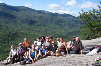
Photo by Kathleen Hudson
Sixteen excellent half-day hikers gathered on a beautiful day which was most welcome after almost two weeks of nonstop rain. The trail was a bit wet in places and well worn with many roots to navigate around. We hiked at a very good pace. There was a paper wasp nest knocked down in the trail just before the helipad and six (6) hikers were bitten. We took a long stop at the top. (See attached picture). On the way down a very nice person had blocked the trail before the wasp nest and we followed a man-way through the woods bypassing a second encounter. All returned safely back down to their cars. We left the parking lot at 1:30 and returned at 5:45--Kathleen Hudson
HALF-DAY NO. H0904-615 Oct. 4
Black Balsam Loop via Graveyard Ridge Trail & ALT *12:30 PM
Hike 6, Drive 70, 1200 ft. ascent, Rated B-B
Nonmembers, call leader, Lucy Prim, 828-693-6580, 32lucette@gmail.com
P400 *Note early start time. Meet at Westgate at 12:30 PM to form carpools, and meet leader at Cold Mountain Overlook at 1:10 PM. Begin at FS 816, north on MST to Graveyard Ridge Trail. Left on Graveyard Ridge Trail to Ivestor Gap. Return on Art Loeb over Tennant Mtn. and Black Balsam.
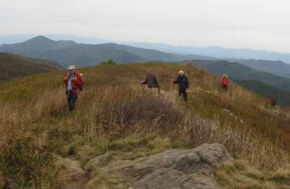
Photo by Lucy Prim
Twenty people went out on this lovely hike. We saw beautiful sweeps of purplish red blueberry bushes and a wonderful slate gray sky of low clouds. Up on the ridge the wind blew so hard we felt like we might be blown off the mountain. Our fingers got so cold we could barely pick blueberries. Not all of us were prepared for such a cold blustery situation, so we hurried along, too cold and windblown to stop and linger at the top of Black Balsam. We felt very adventurous out in that cold gale, with the wind driven rain drops pelting us like little bullets. It was nice to experience such cold, and especially nice to reach our cozy warm cars at the end of the hike!--Lucy Prim
--Back to Top
WEDNESDAY Strenuous NO. W0903-132 Sept. 16
Mt. Mitchell from Black Mtn. Campground *8:00 AM
Hike 12, Drive 103, 3600 ft. ascent, Rated A-AA+
Rich Sampson, 704-453-9059, richsampson360@gmail.com
SB6K, LTC *Meet at Westgate at 8:00 AM to form carpools, and meet leader at Mt. Mitchell overlook (MP 350) on the Blue Ridge Parkway at 8:45 AM. From the Black Mountain Campground ascend by MST to Mt. Mitchell and return. Topos: Celo, Mt. Mitchell, Burnsville; also USFS South Toe River map.
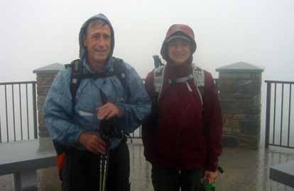
Photo by Rich Sampson
Three hearty hikers, including the leader, made the hike up Mt. Mitchell from Black Mountain Campground despite a light rain. The group left the trailhead at 10:00 at elevation 3000 feet. We stopped for lunch at about the 5,000 foot level and continued on to the top, arriving at the summit at about 3:00. The descent was a bit tricky due to the wet rocks at the higher elevations but we were able to keep up a steady pace, arriving back at the campground at 6:00. While we did have rain off and on all day, it was never a heavy rain. Needless to say, the views were totally blocked by heavy clouds and fog, but the ever changing natural environment was quite interesting as we progressed into higher elevations.--Rich Sampson
WEDNESDAY Moderate NO. W0903-476 Sept. 16
South Mills River, Mullinax Trail and Laurel Creek Trail *8:30 AM
Hike 8.6, Drive 50, 1200 ft. ascent, Rated B-B
Sawako Jager, 828-687-2547, Baiko70@aol.com
P400 South Mills River to Mullinax Trail, to Laurel Branch Trail, then to Bradley Branch, then back by Pea Gap to trailend. Creek crossings – bring water shoes and hiking poles. Second meeting place: Boylston Baptist Church parking lot at 9:00 AM. Topo: Pisgah Forest
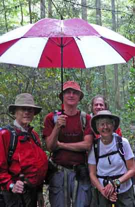
Photo by Sowako Jager
In spite of the rain, five of us hiked the core section of Turkey Pen. After a warm-up climb up the Mullinax Trail, we enjoyed the peaceful forest, the vast fields of ferns, and the beautiful cascades along the Squirrel Gap Trail and the Laurel Creek Trail. We saw a variety of mushrooms and lots of acorns that reminded us that fall has already come. Once we reached the Bradley Branch Trail and after lunch, the fun began.
There were four creek crossings and we waded the nice and cool water, which was as high as between our calves and knees.The second creek had two cables, but they were too loose to do the cable crossing safely. We took the unofficial trail which was very scenic back to the South Mills River, then the gravel road back to the trailhead parking lot. We realized we were the only ones parked there. One more thing I must add is advice for those who have tried everything possible to protect yourself from getting soaked on a rainy day hike. The latest and hottest trend is to bring an umbrella with you! See the picture--.Sawako Jager
WEDNESDAY NO. W0903-357 Sept. 23
Pisgah Ridge Loop 9:00 AM
Hike 7.5, Drive 70, 1500 ft. ascent, Rated B-B
Joe Burchfield, 828-298-8413, burchfield@niu.edu
P400 We’ll do a scenic circle of the entire Graveyard Fields area, using the Pisgah Ridge Trail and MST to lunch at a beautiful overlook. Then the Graveyard Ridge Trail, with trip to one of the Yellowstone Falls. Possible blueberry sightings. Second meeting place: Cold Mtn. overlook on BRP at 9:35 AM. Topos: Shining Rock, Sam Knob; also NatGeo map #780 and USFS Shining Rock map
After a week of heavy rain, fate smiled upon the fifteen hikers who gathered for a loop hike around Graveyard Fields. The sun was bright through the trees as we left the Graveyard Fields Overlook and began our walk along the unmapped county boundary trail. Low clouds still obscured our view of the Davidson River valley below us, but when we turned toward Black Balsam, clear air and bright sun made the early fall colors stand out in sharp relief. The effect of the recent rains was apparent when we reached the MST. Springs, long dry, sent water flowing down many sections of the deeply eroded trail. At our lunch spot on the side of Black Balsam we had a grand view across Graveyard Fields before new clouds began to blow in. We continued the hike along the MST above the Dark Prong and then turned past the Lower Falls to return to our cars. A beautiful early fall day.--Joe Burchfield
WEDNESDAY NO. W0903-287 Sept. 30
Montreat Ridge hike *8:10 AM
Hike 11, Drive 40, 2800 ft. ascent, Rated A-AA
Ames Tryon, 828-669-3805, tryonaf@charter.net
*Meet at Westgate at 8:10 AM to form carpools, and meet leader at Ingles parking lot adjacent to McDonald’s at Exit 64 of I-40 at 8:30 AM. We will ascend up the Rainbow trail and connect with the Trestle Road up to the East Ridge Trail, then descending to the Old Trestle Road to the Old Road up to the Greybeard Trail. Then to the Greybeard Summit along the West Ridge Trail and back along the West Ridge Trail to Stomping Knob. The hike is strenuous but gradual except for the 500 ft. ascent up the Rainbow Trail. Topo: Montreat
Hike #287 was changed to hike #627 due to trail conditions and timing. The hike covered most of the essentials of the original hike including 3200 vertical and approximately 9.7 miles. Weather conditions were excellent and the hike featured numerous views in spite of the heavy leaf cover. Fourteen hikers completed the journey. Except for a few cramps and a little fatigue, everyone seemed to enjoy the day.--Ames Tryon
WEDNESDAY NO. W0904-190 Oct. 7
MST: Mt. Mitchell to Balsam Gap * 8:00 AM
Hike 9.5, Drive: 80, 1700 ft. ascent, Rated A-A
Mary Beth Gwynn: 828-545-6487 (cell) or 828-254-2042 (home). mbgcmc@gmail.com
*Only meeting place will be the back parking lot of Folk Art Center. Please note: Much of the trail is on large moss covered rocks, lovely, but potentially slippery if wet. Appropriate shoes and perhaps poles are advised. This is a particularly beautiful section of the MST with spectacular views from our lunch spot. Car shuttle. Topos: Mt. Mitchell, Montreat; also PNF South Toe River, Mt. Mitchell & Big Ivy Trail Map
Reports for Wednesday hikes during the eNews publication week will appear in the following eNews--The Editor.
--Back to Top
All-day hikes submitted by Bruce Bente 692-0116, bbente@bellsouth.net . Driving distance is round-trip from Asheville. All Saturday and Sunday hikes assemble at Westgate Shopping Center near I-240 UNLESS OTHERWISE NOTED.
Half Day hikes submitted by Lucy Prim 828-693-6580 lucette32@mchsi.com.
Wednesday Hikes are submitted by Charlie Ferguson, 828-398-0213 ccf108@gmail.com and Ann Gleason, 828-859-9387,
gleason.ann@gmail.com .
The meeting place for each hike will be designated by the hike leader and appears in the hike description.
Driving mileage is round trip, based on the first designated meeting place. Meet at Westgate unless otherwise noted.
|
