All Day Saturday & Sunday
SATURDAY NO. A0904-365 Oct. 10
Mt. Mitchell Ramble *10:00 AM
Hike 7, Drive 75, 1400 ft. ascent, Rated B-B
Tom Sanders, 828-252-6327, tomary.avl@gmail.com
SB6K *Note later start time. We’ll do a loop on several trails in the Mt. Mitchell area, including the Old Mt. Mitchell Trail, Camp Alice Road and the Commissary Ridge Trail. Second meeting place: Craven Gap on BRP at 10:20 AM Topos: Mt. Mitchell, Montreat; also PNF South Toe River, Mt. Mitchell & Big Ivy Trail Maps
This hike was cancelled. Two other persons showed up, and since it was raining, we persuaded each other that it was not a great day to hike. This decision was justified as it continued to rain for several hours thereafter.--Tom Sanders.
ALL DAY NO. A0904-668 Oct. 11
Chunky Gal Trail, Deep Gap to Glade Gap *8:00 AM
Hike 8, Drive 170, 1200 ft. ascent, Rated B-B
Brent Martin, 828-369-7084, brent_martin@tws.org
*Meet at Westgate at 8:00 AM to form carpools, and meet leader in Franklin at the Roller Mill shopping center, in front of K-Mart, on US 64 at 9:30 AM. A stop will be made at the rest stop beyond Waynesville on US 23/74 at 8:30 AM. Starting at Deep Gap, we’ll hike 3 miles on the AT before turning onto the Chunky Gal Trail. We’ll travel along the ridgeline with mountain views and old growth oak trees before descending to Glade Gap. Topos: Rainbow Springs, Shooting Creek; also NatGeo map #784
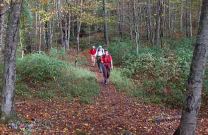 
Photos by Ted Connors
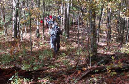
ALL DAY NO. A0904-265 Oct. 18
Panthertown Prowl *8:00 AM
Hike 9.3, Drive 120, 2000 ft. ascent, Rated A-A
Stu English, 828-883-2447, stuengo@citcom.net
*Meet at Westgate at 8:00 AM to form carpools, and meet leader at Bi-Lo in Pisgah Forest at 8:35 AM. This moderate loop hike has everything: waterfalls, granite domes with impressive cliff, high altitude bogs; a lovely valley floor, great views from the tops of Little Green and Big Green Mountains and brilliant fall leaf color. Topo: Big Ridge
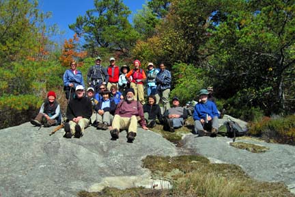
Photo by Danny Bernstein
As the scheduled leader, Stuart English, had to work; Bruce Bente offered to lead the hike. After the cold and wooly weather on Saturday, it was a question whether we'd be able to do this hike. But Sunday morning dawned clear and 35 degrees, and 20 hikers showed up for one of CMC's most scenic hikes.
We got almost to the trailhead before discovering that the enormous pothole had gotten deeper since our scouting hike 10 days earlier, but everyone was able to find parking along the gravel road.
When given the choice of going straight down the old road or taking a side trail past Wilderness Falls, everyone opted for the falls, so we went down this way. The steep portion was negotiated safely and most people went down the manway for a good view of the falls from the bottom. A number of rest/water/snack breaks were taken at the beach, Schoolhouse Falls and the summit of Little Green. We stopped long enough at the falls for people to walk around and behind the falls, and had lunch in bright sun there, out of concern that it would be too windy and cold on top of Little Green.
The various hidden turns were traversed correctly and we stopped again for an ooh-aah break on top of Big Green, another one down at Granny Burrell Falls and finally at the "first" overlook up high on the entry road just before leaving the valley.
Everyone enjoyed the hike, even though many of the brightly-colored leaves had been blown down by the cold weather. Supper for 7 of us was at the Twin Dragons buffet in Brevard. --Bruce Bente
--Back to Top
Half Day Sunday
HALF-DAY NO. H0904-665 Oct. 11
MST from NC 128 (Mt. Mitchell Road) to a waterfall and back *12:30 PM
Hike 6, Drive 62, Rated C-C
Nonmembers, call leader, Marcia Bromberg, 828-505-0471, mwbromberg@yahoo.com
*Note early start time. Single meeting place: lower parking lot at the Folk Art Center at 12:30 PM. A gentle hike along the MST to a lovely waterfall and return. We'll have fall views along the BRP on the drive up to the Mt. Mitchell Road where the hike begins.
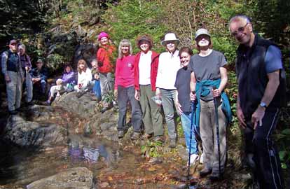
Ph0t0 by Marcia Bromberg
Sixteen hikers enjoyed the beautiful drive up the BRP where leaves were at peak color as we approached the beginning of the hike on Mt. Mitchell Road. Although not the most exciting segment of the MST, the leaf colors, the fog that drifted in and out and the blueberries we picked along the way made this a very satisfactory hike. The picture shows a rather "shady" cadre of hikers at the hike's endpoint.--Marcia Bromberg
HALF-DAY NO. H0904-465 Oct. 18
Sam Knob Loop *12:30 PM
Hike 5, Drive 70, 1200 ft. ascent, Rated C-B
Nonmembers, call leader, Chris Allen, 828-645-0357, chrispallen@me.com
P400, SB6K *Note early start time. There will be a variety of views, terrains and environments. From the parking lot at the end of FS 816 off the Blue Ridge Parkway, we will take the Sam Knob Trail up Sam Knob (6040 ft.) to Flat Laurel Creek, then through a spruce forest to return. Second meeting place: BRP Cold Mountain Overlook at M.P. 412 at 1:10 PM
Because of the BRP closing, the 5 of us who met at Westgate shared the ride in one car to Cold Mountain Overlook for the second meeting point. Upon arrival, there was a major traffic jam at the intersection of US 276 and the BRP; and the overlook lot was overflowing with cars out into the parkway itself. It turns out that the BRP was closed from that point south, completely cutting off our route to the Sam Knob trail head at Black Balsam parking lot. In addition, we learned from Ted Connors who was waiting at the overlook that the BRP north of that intersection toward Pisgah Inn had only reopened 15 minutes earlier from an accident on the parkway. That closure had cut off access for one of the hike party that had been coming up via Route 151.
There were about 2 inches of snow on the ground at the Cold Mountain overlook and all the trees were coated with a beautiful skin of icy snow. The wind was cold and very strong -- probably about 35 degrees based on the Wunderground forecast and winds at 15-20 mph with gusts up to 35. Two of the hike party were inadequately prepared for that degree of wind and cold, so with creative inspiration from Ted, all 8 of us agreed to drive back down US 276 to the Fish Hatchery and hike up to John Rock.
We enjoyed the hike up to John Rock, though one of the party was not comfortable with the fast pace due to our late start (~2:45 at that point), so she and another hiker went back to the parking lot to await our return. Six of us made the hike to the top of John Rock and returned via the same route, arriving back at the parking lot ~5pm. All reported having a fun day in spite of the unexpected surprises, and hope to make it to Sam Knob sometime in the future.--Chris Allen
--Back to Top
WEDNESDAY NO. W0904-408 Oct. 14
Wolf Ford-Horse Cove Gap Loop *8:30 AM
Hike 9, Drive 70, 1200 ft. ascent, Rated A-B
Greg Goodman, 828-684-9703, greggoodman@bellsouth.net
P400 *Meet at Westgate at 8:30 AM to form carpools, and meet leader at Pisgah Ranger station at 9:05 AM. This hike takes the S. Mills River Trail to Wolf Ford, then goes left on Squirrel Gap Trail to the Horse Cove Trail to FS 5018 then back to Wolf Ford and cars. Topo: Pisgah Forest; also NatGeo map #780
One hiker showed. Hiked to Wolf Ford and back. Wet, wet, wet.--Greg Goodman
WEDNESDAY NO. W0904-672 Oct. 21
Bee Tree Gap to Glassmine Falls O/L 9:00 AM
Hike 7, Drive 55, 1950 ft. ascent, Rated B-A
Bruce Bente, 828-692-0116, bbente@bellsouth.net
Hike a scenic section of the MST with great views along the way. Car shuttle. Second meeting place: Craven Gap at 9:20 AM Topos: Craggy Pinnacle, Montreat; also MST Profiles, pg. 65-66
Reports for Wednesday hikes during the eNews publication week will appear in the following eNews--The Editor.
--Back to Top
All-day hikes submitted by Bruce Bente 692-0116, bbente@bellsouth.net . Driving distance is round-trip from Asheville. All Saturday and Sunday hikes assemble at Westgate Shopping Center near I-240 UNLESS OTHERWISE NOTED.
Half Day hikes submitted by Lucy Prim 828-693-6580 lucette32@mchsi.com.
Wednesday Hikes are submitted by Charlie Ferguson, 828-398-0213 ccf108@gmail.com and Ann Gleason, 828-859-9387,
gleason.ann@gmail.com .
The meeting place for each hike will be designated by the hike leader and appears in the hike description.
Driving mileage is round trip, based on the first designated meeting place. Meet at Westgate unless otherwise noted.
|
