
Carolina Mountain Club
Hike - Save trails - Make friends
February 12, 2010
 Check us out on Facebook.
|
|
|
| Upcoming Hikes | Hike Reports |Maintenance Schedule |
| What's Happening in the Next Three Weeks | Guns in National Park becomes law |
| Other Important News | Congaree National Park weekend coming up |
| Review | Review of new Pisgah NF map |
| Conservation Matters | Swain County Financial Settlement |
| Interview | Meet Tom Sanders |
| Heard on the Ground | Trail sections up for adoption |
| Heard on the Trail | California Dreamin' |
| The Small Print | Deadlines, change of addresses and other details |
|
From Your Editor If you look at the bylines carefully, you'll see that more people are writing for the eNews. In this issue, Dave Wetmore has a review of a new map, Stuart English write about a conversation with Tom Sanders and Janet Martin tells us about the hiking in California. And that's great. More voices means a more engaging eNews. You don't have to be an "English major" to write a couple of interesting paragraphs about an outdoor topic you're passionate about. Want some ideas? Interview a CMC member that you want to talk to. See if they've already been interviewed. Review a recent outdoor book. Write a trail that we should know about. A photo always helps. Just keep it about the outdoors and factual. Danny What's Happening in the Next Three Weeks Guns in National Parks Becomes Law on Feb. 22 On Monday February 22, visitors in National Parks can now bring in firearms in national parks, including the Great Smoky Mountains National Park. There are many rules on where and how this can be done. The best official source of regulations are in http://www.nps.gov/grsm/parkmgmt/lawsandpolicies.htm For a wider discussion of the ruling, National Parks Traveler has a good article. Winter Plant ID Hike Rescheduled to Feb. 20 The winter plant ID hike that was snowed out on Jan. 20 has been rescheduled to Saturday, Feb. 20. This is a reservation only hike, so sign up soon. Details at http://www.carolinamtnclub.com/Hiking/Schedules/sundays-all-day-10-1st.asp. Contact Becky Smucker at bjsmucker@gmail.com. CMC Weekend at Congaree National Park
We'll canoe, hike and socialize. Free primitive camping in the park (not backpacking) is available in the park or you can stay in a motel a few miles away. More information will be forthcoming. In the meantime, save the weekend - April 16-18. This is a CMC weekend and everyone must be a CMC member. Space is limited. Danny (Picture is from the NPS website.) Trails Conference Looking for Presentations "Trails: The Green Way for America" is the theme of the 20th American Trails National Symposium, to be held in Chattanooga, Tennessee, Nov. 14-17, 2010. To help us develop an exciting and motivating program for the Symposium, we invite you to submit ideas for presentations in support of the Symposium’s theme. We expect to offer 40 concurrent sessions, each lasting 75 minutes. Proposals are due by April 9, 2010. Look at the details. Pisgah National Forest Map reviewed by Dave Wetmore There is a new edition of the Trails Illustrated map of the Pisgah Ranger District (Map #780). The front of the new one is different; it has a red triangle at the top right and about a quarter of the way down the front of the map is a short coverage list on a red background. The price is different too, up $2 to $11.95. The new map seems to be printed on slightly heavier stock. The two sides of the map are no longer east and west sides, but north and south sides. This allows more coverage of the South Carolina trails. The map now has a complete UTM grid. The spheroid and datum are still the same as for the 7.5 minute quadrangles. Any map is a set of compromises, and the compromises have changed in this new edition. On the good side it has more coverage: the western portion of DuPont State Forest, the western portion of Caesar’s Head State Park, most of Table Rock SP, Gorges SP and Panthertown in addition to the Pisgah Ranger District. This increased coverage comes at a price. The scale has been reduced from 1:44500 to 1:50000 (0.7 miles per inch to 0.8 miles per inch) and the contour interval increased from 40 feet to 50 feet. There are many more numbered trails and the trail list on the map is at last ordered by number! This is the first edition where it is easy to find the name of a trail you are on. The Panthertown trails, although numbered, are not on the trail list. There have been some corrections on trail and road routes. I spotted two, the Seniard Ridge trail and Kagle Mountain road. They did not remove the little boxes that cover up portions of the map, but there are fewer of them, 12 vs. 16. Seven of them are admonitions to respect private property. The short lecture on waterfall safety no longer covers Fork River and Lanning Ridges, but is near the margin, which is a start. There is a box between Club and Buckhorn gaps which puzzles me. It says “Footbridge can be accessed by foot only.” On balance, this edition is much better than its predecessor and well worth the money. Dave Wetmore Historic Signing in Bryson City - North Shore Issue is now resolved.
Talking to Tom Sanders by Stuart English
Recently, we caught up with Tom and persuaded him to share some of his life and thoughts with us. Read the interview. Picture of Tom on the MST by Danny Bernstein
Adopt a Section of the A.T. None at this time. Adopt a Section of the MST Old Bald Access to Richland Balsam Access, 4.4 miles, section maintainer needs an assistant Richland Gap Access to Richland Balsam Access (3 Trees) 1.2 miles If you're interested in either the A.T. or MST, email Don Walton. Maintenance Reports created by Don Walton
California Dreamin' Janet Martin, an active CMC hiker, is spending the winter in California with her new granddaughter. She didn't lose any time joining a hiking club while there. Here's her report on one of her hikes.
Divide Peak straddles the boundary between Ventura and Santa Barbara Counties within the Matilija Wilderness, a protected area of the Los Padres National Forest. From the trailhead at 1,515 ft., the hikers walked briskly along a dirt road thru a barren area for .6 mile to Matilija Canyon Ranch (an inholding). The steady pace of 3+ mph continued on a trail up a broad canyon to Murietta Divide. The trail was hardpacked, gritty dirt for easy walking with few rocks and no roots. For the next half mile, there were a few, fragrant eucalyptus trees and an occasional stubby oak or alder followed by a steady climb without switchbacks through chaparral with sparse vegetation to Murietta Divide; the sagebrush was more gray than green. Being on the north side of the Santa Ynez Mountains provided shelter from the blazing sun. Lots of bear scat along this section of trail. From the divide, we climbed 1,092 ft. in 0.8 mile due south without a defined trail thru thick brush. The leader would point out a rock outcropping and say to find your way to that point and then regroup. Basically, the climb was cross country from firebreak to firebreak. The unyielding 3-5 ft brush consisted of manzanita with sturdy, deep red, smooth limbs that whipped back with leathery green leaves and spiny ceanothus (a/k/a california lilac, buckthorn family) with innumerable 1-1/2 inch, skinny thorns that grab everything and everyone. (The return down this slope was treacherous because the sandy ground acted as a lubricant making a very slippery descent and no destination was obvious as a directional guide.) The next mile was spent dodging trail bikes on an OHV trail. The final steep approach brought us to the south side of the peak, the summit, and rewarding views. South, seven of the eight Channel Islands were visible, including Santa Catalina across from LA. East, far below was Lake Casitas with its island. North, views of snow laden summits in the distance. West, row after row mountain ranges with views of the Pacific Ocean as backdrop. As a couple of the hikers had trudged thru snow to do this hike in January 2009, we stayed nearly two hours on the summit on this gloriously clear day. Janet Martin The eNews comes out on Fridays. So ... The next issue will come out on Friday, March 5. Wednesday hike reports for the hike just before the eNews comes out will be published in the next eNews. Hiker leaders, please send all your eNews hike reports and photos to Dave Wetmore at dwetmore@citcom.net So send me your news and maintenance reports by Tuesday evening at 9 P.M. before the newsletter comes out, that is, by Tuesday evening March, 2010 to Danny Bernstein at danny@hikertohiker.com. Include your email address at the end of your story. Thank you. The CMC Calendar is meant to answer the perennial question "When is this happening again?" It is also meant to prevent conflicts between competing CMC events. Please check it often. How to join the Carolina Mountain Club If you are a non-member subscriber, you need to go back to the | ||||||
Danny Bernstein
danny@hikertohiker.com
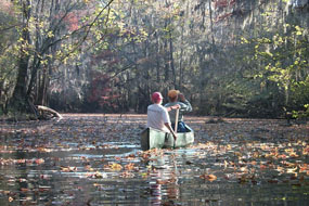 Join CMC on a weekend to Congaree National Park south of Columbia, South Carolina April 16 to 18. In three hours of driving, you'll reach another world from the mountains. Check out
 Tom Sanders is not only one of our stronger hikers, but also is one of our most enjoyable personalities. He brightens every hike he is on and has never met a stranger.
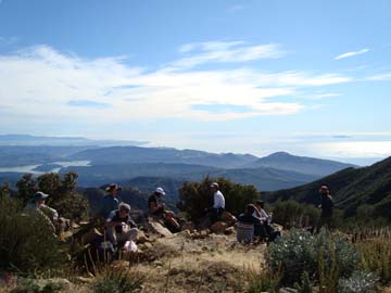 Divide Peak hike, 14 miles RT, 3192' elevation gain