All Day Saturday & Sunday
SATURDAY NO. A1001-019 Jan. 30
Winter Plant ID hike 9:00 AM
Hike 8, Drive 20, 1200 ft. ascent, Rated B-B
Becky Smucker, 828-298-5013, bjsmucker@gmail.com
P400 This moderate-paced hike is designed for identification of plants in the winter. Bring magnifying glasses if you have them. We’ll hike the MST between the French Broad River Overlook and a little beyond Walnut Cove, stopping often to look at various plants along the way. Limited to 12 people; contact leader for reservation. Topo: Skyland; also NatGeo map #780 and MST Profiles book, pg. 57
SUNDAY NO. A1001-596 Jan. 31
Foothills Trail: Laurel Fork Gap to Lake Jocassee *8:00 AM
Hike 10.8, Drive 103, 1400 ft. ascent, Rated A-B
Michael and Kathy Cornn, 828-458-1281, mcornn@aol.com
*Form carpools at Westgate, and meet leaders at Bi-Lo in Pisgah Forest at 8:30 AM. We’ll hike the Foothills Trail in SC, from Laurel Fork Gap to Lake Jocassee. This in-and-out hike along Laurel Fork Creek features a beautiful stream, waterfalls, great bridges, and a scenic lakeside lunch spot. Topos: Eastatoe Gap, Reid; also Foothills Trail map
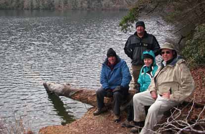 
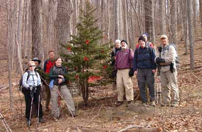
Photos by Kathy Cornn
The promise of a sunny day inspired five hikers to risk questionable road conditions to take a walk on the Foothills Trail to Lake Jocassee. The forest road to the trail head had a few limbs down, but Paul and Carroll maneuvered around them to make it 3.7 miles to the trail head.
Ice and snow weighed down and broke rhododendrons and trees along the trail and required ducking, crawling and scrambling. By the time we made it to Lake Jocassee there was no snow. The island or peninsula present two years ago when the hike was led by Paul was gone because the water levels had risen dramatically. Cold, clouds and chilly winds kept us from enjoying the destination too long. There was no warm sun to bask in. We were quickly warmed by the ascent. The five ended the hike at Dougan's with French onion soup.--Kathy and Michael Cornn
SUNDAY NO. A1001-093 Feb. 7
Graybeard Mountain 8:00 AM
(strenuous)
Hike 11, Drive 35, 2700 ft. ascent, Rated A-AA
Tom Sanders, 828-252-6327, tomary.avl@gmail.com
An exciting ridgetop manway along the middle mountain is our path to the summit. Return to Montreat via Walker Knob and Pot Cove Gap. There’ll be good views, a delightful hike and a good workout. The first mile is very steep. Second Meeting place: Ingles parking lot at Exit 64 of I-40 at 8:20 AM. Topo: Montreat; also Montreat Trails Map
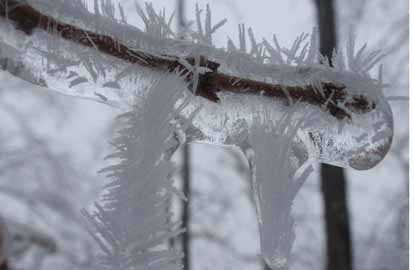 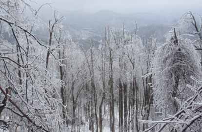
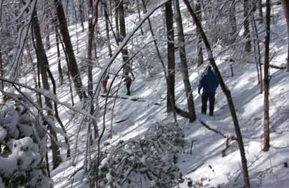
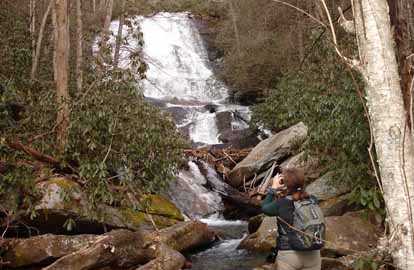
Photos by Bruce Bente
The hike leader, Tom Sanders, was feeling under the weather, so Bruce Bente led this hike. Due to impracticality of doing the scheduled Graybeard hike (deep snow, ice, blowdowns), hike #238 around Montreat was substituted. This hike started with a short walk around the original Montreat reservoir, went up Graybeard Trail to Pot Cove Gap, and then followed the Old Mitchell Toll Rd. and Ridge Trail. Then we dropped steeply down Buck Gap Trail, then Trestle Trail and finally Lookout Trail and Lookout Rd.
This 7-mile hike with 5 hikers took about 6 hours, including many photography stops, and proved to be a beautiful and strenuous hike. We started out on about 4" of snow and climbed up into deeper snow and rime ice. The four stream crossings were handled successfully and by the time we got to Pot Cove Gap, we were into the midst of evidence of an ice storm, with thick ice coating everything. Lots of blowdowns, broken branches and bushes bent over the trail. The types of ice and rime ice varied along the route, with some unusual rime that looked like needles sticking out. At one point where the ice coating on branches approached an inch, occasionally there would be a loud crack and then a tree branch would fall, none too near us fortunately. A steep climb over Brushy Mtn. inspired questions about the hike leader's sanity.
There was an ice layer in the snow which made the going challenging, especially going downhill where it was necessary to punch a heel into the snow/ice to avoid sliding down the mountain. Lunch was held at the Buck Gap shelter in dry conditions.
My 4-year old Yaktrax proved to be invaluable for traction and are highly recommended. Two other hikers had the walker type of Yaktrax which kept loosening, so be aware that there are two different types.--Bruce Bente
SUNDAY NO. A1001-104 Feb. 7
Wolfe Ford and High Falls *9:00 AM
(moderate)
Hike 7.3, Drive 80, 900 ft. ascent, Rated B-C
Rich Bowerman, 828-808-2891, pcdbowerman@hotmail.com
P400 *Form carpools at Westgate, and meet leader at Bi-Lo in Pisgah Forest at 9:30 AM. From the gauging station on the South Mills River, we'll hike this mostly level trail to High Falls, then cross the footbridge at Wolfe Ford and loop back to the trailhead. Two small stream crossings. Topo: Pisgah Forest; also NatGeo. map #780
--Back to Top
Half Day Sunday
HALF-DAY NO. H1001-686 Jan. 31
Shopes Creek 1:30 PM
Hike 5, Drive 25, Rated C-C
Nonmembers, call leader, Gail Lamb, 828-350-0450, galmb46@bellsouth.net
This is a short ride for a winter walk in the woods, partly along Shopes Creek in the Riceville Rd. area. It has been recently opened to hikers and has some unmarked trails, some of which are near, but not to the Parkway.
Cancelled due to the weather.
HALF-DAY NO. H1001-640 Feb. 7
Walker’s Knob - Montreat *12:00 PM
Hike 5, Drive 40, 1800 ft. ascent Rated C-A
Nonmembers, call leader, Renate Rikkers, 828-298-9988, rerikkers@aol.com
*Form carpools at Westgate, and meet leader at Ingles parking lot at Exit 64 on I-40 at 12:20 PM. We shall hike Greybeard Trail up to Walker’s Knob and back. The hike is a steady 1800 ft. climb with a wonderful view of the Montreat and Black Mountain Valley at Walker’s Knob.
Nobody showed up for the Sunday afternoon hike - I waited in Black Mountain til 15 min. after the agreed meeting time, but I guess the combination of Superbowl and weather kept people at home--Renate Rikkers
--Back to Top
WEDNESDAY NO. W1001-599 Jan. 27
Daniel Ridge-Caney Bottom Cove Creek Falls Loop *8:30 AM
Hike 10, Drive 80, 1800 ft. ascent, Rated A-A
Stuart English, 828-883-2447, stuengo@citcom.net
P400, WC100 *Form car pools at Westgate, and meet leader at Pisgah Forest Ranger Station at 9:05 AM. We’ll start with the 4-mile Daniel Ridge Loop, ending at Toms Springs Falls, a 100 foot falls. From these falls, we’ll follow an old FS road, go down an unmapped trail to Caney Bottom Trail. Here we’ll loop around to Cove Creek Trail and 60 foot Cove Creek Falls, then back to Caney Bottom Loop and eventually back to our cars on Davidson River Road (FS 475). Topo: Shining Rock; also NatGeo map #780
Photos by Stuart English
Ten people gathered for this one on a brisk morning. We started up the Daniel Ridge Trail on Daniel Ridge Creek and soon were on the Right Fork, two great streams in the Pisgah Ranger District. As we crossed over Lanning Ridge, we passed a young hemlock that someone had decorated for Christmas. Soon we headed down toward Toms Springs Falls, one of the tallest waterfalls around here. Then we headed up a FS road and down a unmarked trail into Cove Creek Campground where we ate lunch on the picnic tables. Then we visited Cove Creek Falls, another great Pisgah waterfall. After that we took the Caney Bottom Trail up Caney Bottom Creek with its several cascades to its intersection with Cove Creek Trail. Everyone agreed that it was great to finally get out and hike when so many hikes were cancelled. It seemed that we were always seeing water and when we weren't we could still hear it.--Stuart English
WEDNESDAY NO. W1001-279 Feb. 3
Montreat Trestle Grade-Pot Cove Trail 8:30 AM
Hike 8, Drive 35, 1900 ft. ascent, Rated B-A
Joe Burchfeld, 828-298-8413, Burchfield@niu.edu
A partial loop hike over Lookout Rock and along the East Ridge and Trestle Road Trails to Pot Cove. Return along the Mitchell Road and Trestle Road Trails. A moderately strenuous beginning followed by a very gentle return. Good winter views. Second meeting place: Ingles parking lot at Exit 64 of I-40 in Black Mountain at 8:50 AM. Topo: Montreat; also Montreat Trail Map.
Although the weather had cleared, the hike was canceled due to extensive ice on the Montreat trails. A few hearty souls chose to do an informal alternate hike in the Arboretum.--Joe Burchfield
WEDNESDAY NO. W1001-041 Feb. 10
Sugar Cove Rd to Mackey Mountain 8:30 AM
Hike 11.5, Drive 87, 2900 ft. ascent, Rated A-AA
Ames Tryon, 828-669-3805, tryonaf@charter.net
Take Sugar Cove Creek trail to Mackey Mountain Trail and then on Mackey Mountain Trail to Mackey Mountain and return the same way. Second meeting place: Ingles parking lot at Exit 64 of I-40 at 8:50 AM. Topo: Old Fort; also NatGeo map #779
Reports for Wednesday hikes during the eNews publication week will appear in the following eNews--The Editor.
--Back to Top
All-day hikes submitted by Bruce Bente 692-0116, bbente@bellsouth.net . Driving distance is round-trip from Asheville. All Saturday and Sunday hikes assemble at Westgate Shopping Center near I-240 UNLESS OTHERWISE NOTED.
Half Day hikes submitted by Lucy Prim 828-693-6580 lucette32@mchsi.com.
Wednesday Hikes are submitted by Charlie Ferguson, 828-398-0213 ccf108@gmail.com and Ann Gleason, 828-859-9387,
gleason.ann@gmail.com .
The meeting place for each hike will be designated by the hike leader and appears in the hike description.
Driving mileage is round trip, based on the first designated meeting place. Meet at Westgate unless otherwise noted.
|
