|
All Day Saturday & Sunday
SATURDAY No. A0804-447 Oct. 25
MST: Mt. Pisgah to Beaver Dam Overlook *9:00 AM
Hike 8.5, Drive 45, 1700 ft. ascent, Rated B-A
Victoria Tripp, 828-348-4505, torrose@gmail.com
P400 *Note later start time. This moderate hike will start with a round trip up and down Mt. Pisgah, and will then follow the MST northbound to Beaver Dam Overlook. Expect good views and bright leaf colors along the route. Short car shuttle. Second meeting place: BRP French Broad Overlook at 9:10 AM. Topos: Cruso, Dunsmore Mtn.; also Nat’l. Geo. PRD map #780 & MST Profiles, pg. 53-55
ALL DAY No. A0804-622 Oct. 26
Cold Mtn. via Crawford Creek 8:00 AM
Hike 10.7, Drive 65, 3100 ft. ascent, Rated A-AA
Dave Wetmore, 828-884-7296, dwetmore@citcom.net
SB6K The Club has received permission to have a hike on private property north of Crawford Creek. This is the easy way to the summit of Cold Mountain. We will follow old roads to Deep Gap and take the Forest Service trail to the summit. This route is the one the designers of the Art Loeb trail had hoped to use. This is a Wilderness area with a limit of 10 hikers, so please reserve a spot by contacting the leader. Note that we have permission to cross this property for only this one hike. Topo: Cruso
ALL DAY No. A0804-063 Nov. 2
Big East Fork, Art Loeb Trail, Shining Creek Loop 8:00 AM
(strenuous)
Hike 13, Drive 70, 2800 ft. ascent, Rated AA-AA
Tom Sanders, 252-252-6327, tomary2@charter.net
P400 A beautiful but strenuous hike (the leader’s favorite) with three of WNC’s most beautiful streams. Up Big East Fork, then Grassy Cove Ridge, and the Art Loeb Trail to Shining Rock Gap, with great views, and then down Shining Creek. Two stream crossings that may have to be waded. Wilderness area, limit 10, so reserve by calling or emailing leader. Second meeting place: Big East parking area on US 276, 3 miles north of BRP at 8:45 AM. Topo: Shining Rock; also Nat’l. Geo. PRD map #780
ALL DAY No. A0804-444 Nov. 2
Avery Creek Loop 8:00 AM*
(moderate)
Hike 10, Drive 80 ,1700 ft. ascent, Rated A-A
Stuart English, 828-883-2447, stuengo@citcom.net
P400 A nice hike featuring waterfalls, beaver dams, and maybe some late fall leaf color. We’ll first climb to Buckhorn Gap via Twin Falls, then follow the Black Mtn. Trail to Club Gap, with our return downhill on the Avery Creek Trail. *Meet at Westgate at 8:00 AM to form carpools, and meet leader at Pisgah Ranger Station on US 276 at 8:35 AM. Topos: Pisgah Forest, Shining Rock; also Nat’l. Geo. PRD map #780
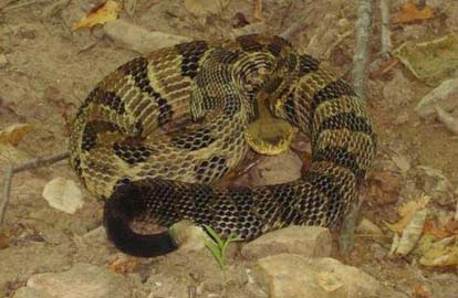 Scouting report: We scouted this hike on October 3 on a beautiful day that is just a preview hopefully of how it is going to be November 2 with more leaves down and much more color. This is the moderate hike on a day which also schedules a strenous hike. I really believe the hike to be very moderate and pleasant. It does involve some climbing in the first half of around 1400 to 1600 feet, but it is fairly gradual. So those who are looking for an alternative to a very tough hike can find one here and still have a good solid hike on what I hope will be as nice a day as it was today. I sent a picture of what you are liable to step on if you succumb to talking politics with Bruce. Stuart. Photo by Stuart English. Scouting report: We scouted this hike on October 3 on a beautiful day that is just a preview hopefully of how it is going to be November 2 with more leaves down and much more color. This is the moderate hike on a day which also schedules a strenous hike. I really believe the hike to be very moderate and pleasant. It does involve some climbing in the first half of around 1400 to 1600 feet, but it is fairly gradual. So those who are looking for an alternative to a very tough hike can find one here and still have a good solid hike on what I hope will be as nice a day as it was today. I sent a picture of what you are liable to step on if you succumb to talking politics with Bruce. Stuart. Photo by Stuart English.
Half Day Sunday Hikes
HALF-DAY No. H0804-009 Oct. 26
Ox Creek Road to Rattlesnake Lodge *1:00 PM
Hike 4.4, Drive 30, Rated C-C
Nonmembers, call leader Don Walton, 828-654-9904, donwalton@bellsouth.net
*Note early start time. This in-and-out hike along the MST will feature the historic Rattlesnake Lodge site. Second meeting place: Folk Art Center lower parking lot at 1:15 PM.
HALF-DAY No. H0804-295 Nov. 2
Pump Gap Loop *1:00 PM
Hike 5.1, Drive 80 ,1200 ft. ascent, Rated C-B
Nonmembers, call leader, Jorge Munoz 828 658-0606 - jmunoz@buncombe.main.nc.us
*Note early start time. This moderate loop hike starts at the Silvermine Trailhead. After a good climb to the ridge, we will visit an old cemetery, cross the AT and return on the Pump Gap Trail.
All Day Wednesday
WEDNESDAY No. W0804-600 Oct. 29
Pink Beds-Buckhorn Gap-S. Mills River loop *8:00 AM
Hike 10, Drive 75, 1000 ft ascent, Rated A-B
Jack Fitzgerald , 828-685-2897, suejackfitz@bellsouth.net
P400 *Meet at Westgate at 8:00 AM to form carpools, and meet leader at Pisgah Ranger Station at 8:30 AM. We’ll start on the Pink Beds loop to Barnett Branch, up to Buckhorn Gap, and then down to the S. Mills river. Hike to gauging station and return to cars on Pink Beds loop. Lots of variety and a moderate pace. Topo: Shining Rock; also Nat’l. Geo. PRD map #780
WEDNESDAY No. W0804-271 Nov. 5
Chestnutwood Mountain 8:30 AM
Hike 9, Drive 70, 1900 ft. ascent, Rated A-B
Lee Silver, 828-668-7147, leehsilver@aol.com.
We will do our major climbing before lunch on this pleasant hike past streams, two nice cascades, a glimpse of the Black Mtns., and a 20 yr. old timber harvest in the Grandfather District. Some bushwhacking and hiking on over-grown trails. Second meeting place: Parking lot adjacent to McDonalds off I-40 at Exit 64 at 8:50 AM. Topo: Old Fort
All-day hikes submitted by Bruce Bente 692-0116, bbente@bellsouth.net . Driving distance is round-trip from Asheville. All Saturday and Sunday hikes assemble at Westgate Shopping Center near I-240 UNLESS OTHERWISE NOTED.
Half Day hikes submitted by Lucy Prim 828-693-6580 lucette32@mchsi.com. Wednesday Hikes are submitted by Charlie Ferguson, 828-398-0213 ccf108@gmail.com and Ann Gleason, 828-859-9387,
gleason.ann@gmail.com .
The meeting place for each hike will be designated by the hike leader and will appear in the hike description.
Driving mileage will be listed, round trip, from the first designated meeting place.
Leaders: Mail please mail your sign-up sheets. Meet at Westgate unless otherwise noted. |
 CMC Bi-Weekly Hike News