|
All Day Saturday & Sunday
ALL DAY No. A0804-620 Oct. 12
Devil’s Courthouse – Pilot Mtn. *8:30 AM
Hike 8.5,Drive 75, 2400 ft. ascent, Rated A-AA
Ashok Kudva, 828-698-7119, ashok.kudva@mchsi.com
P400 *Meet at Westgate at 8:30 AM to form carpools, and meet leader at BRP Cold Mtn. Overlook at 9:10 AM.
Have you ever admired the fabulous views of Pilot Mtn. from Devil’s
Courthouse and the Chestnut Bald and Silvermine Bald overlooks, and wished you could be there?
From Devil’s Courthouse we will follow the MST, and then descend steeply on the roller coaster
ALT to Farlow Gap for lunch at Bruce Rock before proceeding to a snack stop on top of Pilot Mtn.
with its 360° mountain vista. We’ll return to the BRP crossing where a short car shuttle will reunite us with our cars.
Topos: Sam Knob, Shining Rock; also Nat’l. Geo. PRD map
#780
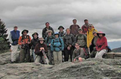 
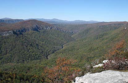
Seventeen hikers assembled at the Devil’s Courthouse Overlook parking lot. We started the hike with a vigorous 300 ft short climb to the top on a damp, cloudy morning. Pilot Mountain, our destination for the day, appeared prominently in the 360 degree mountain vista. Fall foliage on MST to the Art Loeb trail at Silverman Bald, captured by Jeff ‘s photograph, was fantastic as the sun broke through the clouds. Paul Benson led seven hikers bushwhack atop Chestnut Bald, a SB6K peak. Others sat on the nearby rocky face to enjoy Pilot Mountain right in front of them. Our access ridge contour of Farlow Gap-Sassafras Knob-Deep Gap on the Pilot Mountain approach appeared fantastic. We enjoyed snacks, incentive chocolates and fellowship at Bruce Rock in Farlow Gap and on the Pilot Mountain summit with a spectacular 360 degree view. I allowed faster hikers proceed ahead and Bruce who had scouted this hike was among them. After the hike, five hikers paused to photograph and enjoy spectacular foliage at Graveyard Fields. Then they enjoyed a nice supper at Ed Boudreaux’s Bayou BBQ in Brevard. Ashok.
Photos by Jeff McGurk
SATURDAY No. A0804-578 Oct. 18
Flat Laurel Creek, Little Sam Knob, MST Loop *10:00 AM
Hike 7.5, Drive 80, 1300 ft. ascent, Rated B-B
Marcia Bromberg, 828-505-0471, mwbromberg@yahoo.com
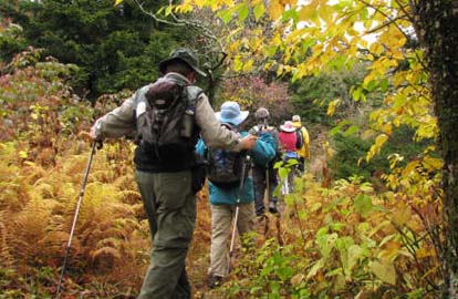
P400 *This will be the first of our Saturday “3/4-day” hikes. These hikes will be scheduled to begin in late Saturday mornings and will be moderate hikes of about 7 miles done at a moderate pace. These hikes are intended to be a little longer than a half-day hike and a bit shorter than the usual all-day hikes. This is a pleasant loop trail with views of Big Sam Knob, Fork Ridge and Flat Laurel Creek. We’ll begin on the Flat Laurel Creek Trail, which ascends gradually until we are hiking next to the creek, where we will stop for lunch. Little Sam Knob Trail, with views of Little Sam Knob and Sam Knob, connects to the MST. A one-mile side trip to Devils Courthouse will offer good views before we return on the MST to our cars. Second meeting place: BRP Cold Mtn. Overlook at 10:40 AM.
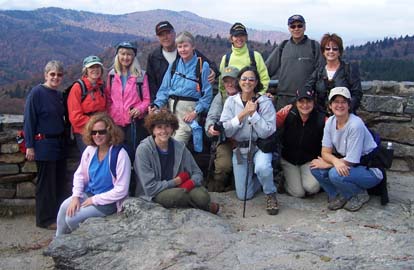 Fourteen hikers turned out for the first of our Saturday, 3/4 day, moderate, later-starting hikes. All agreed that the start time and day suited them well. The weather was a little chilly, but the sunshine helped offset the chill. And the leaves, though just past peak at that altitude, still put on quite a show. Fourteen hikers turned out for the first of our Saturday, 3/4 day, moderate, later-starting hikes. All agreed that the start time and day suited them well. The weather was a little chilly, but the sunshine helped offset the chill. And the leaves, though just past peak at that altitude, still put on quite a show.
We were fortunate on this hike, which included a portion of the MST, to have Kate Dixon, Director of the Friends of the Mountain to Sea Trail. Kate gave a short but informative talk about the Trail just before we began the last leg of the hike which was on the MST.
The group picture was taken at Devil's Courthouse. All and all, the success of this hike and reaction of the hikers bodes well for future Saturday, 3/4 day hikes. Marcia. Photo by Marcia Bromberg.
ALL DAY No. A0804-621 Oct. 19
Linville Progressive 8:00 AM
Hike 8.3, Drive 140, 1800 ft. ascent, Rated B-A
Danny Bernstein, 828-236-0192, danny@hikertohiker.com
We’ll hike the easy trails of Linville Falls to see the falls and Gorge from five spectacular perspectives. After driving on dirt roads on the east side of Linville Gorge, we’ll go up Table Rock Mountain with its fantastic views and then The Chimneys, a set of rocky columns and crevasses. If we still have time and energy, we’ll also climb Hawksbill for an additional 1.4 miles. Optional dinner on the way back. Wilderness area hike, limited to 10 people - call leader for reservations. Second meeting place: Parking lot adjacent to McDonalds at Exit 64 of I-40 at 8:20 AM. Topo: Linville Falls; also Nat’l. Geo. Mt. Mitchell Linville Gorge map #779
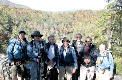 
This progressive hike was meant to hike several small but magnificent trails in the Linville area. The morning was spent at Linville Falls, where we did all the trails - about four miles. We saw the waterfall from every angle and even went down to the gorge. This is an easy way to see the gorge without dealing with the tough trails in the Wilderness Area. Linville Falls is managed by the Blue Ridge Parkway and the trails are manicured.
In the afternoon, we drove to Table Rock Mountain on a dusty dirt road. The drive was much harder than the hike. We had a fantastic day with blue skies and visibility for miles. So it was not surprising that we had lots of company - people up and down and on top. Then we climbed the other side of the parking lot through the Chimneys, an rocky area with unusual rock formations. This was in the Linville Gorge Wilderness Area so we had to limit the number of people to ten. Here we had few hikers but met rock climbers who were also taking advantage of the great weather. We got back to the cars at about five o'clock so we didn't have time to go to Hawksbill. Maybe next time. Danny. Photos by Danny Bernstein
Half Day Sunday
HALF-DAY NO. H0804-146 Oct. 12
Skinny Dip Falls *12:30 PM
Hike 5, Drive 65, Rated C-B, 1300 ft. ascent
Nonmembers, call leader, Renate Rikkers, 828-298-9988, rerikkers@aol.com
P400 *Note early start time. On this in-and-out hike we will start at Looking Glass Rock Overlook, take the Mountains-to-Sea Trail past Skinny Dip Falls, then turn around, have our break at Skinny Dip Falls and then retrace our steps to the parking lot. Bring your bathing suit for a polar bear dip! Second meeting place: BRP Looking Glass Rock Overlook at M.P. 417 at 1:10 PM.
No report
HALF-DAY No. H0804-465 Oct. 19
Sam Knob Loop - Photo HIke *12:30 PM
Hike 5, Drive 70, 1200 feet ascent, Rated C-B
Nonmembers, call leader, Chris Allen, 828-645-0357, cpallen@gmail.com
P400, SB6K *Note early start time. The pace will be slow to allow plenty of time for picture taking. There will be a variety of views, terrains and environments. From the parking lot at the end of FR816 off the Blue Ridge Parkway, we will take the Sam Knob Trail up Sam Knob (6040 ft.) to Flat Laurel Creek, then through a spruce forest to return. Second meeting place: BRP Cold Mountain Overlook at M.P. 412 at 1:10 PM.
No report
All Day Wednesday
WEDNESDAY No. W0804-427 Oct. 15
Soapstone Ridge 8:30 AM
Hike 10, Drive 90, 1200 ft. ascent, Rated A-B
Rich Sampson, 704-453-9059, richsampson360@gmail.com
P400 We will begin at the gauging station and follow a mild bushwhack up
Soapstone Ridge to the Black Mountain Trail which we’ll follow to our lunch spot at Buckhorn Shelte.
We’ll then take the Buckhorn Gap trail down to the S. Mills River trail back to our cars.
Second Meeting Place: PRD Ranger Station at 9:00 AM. Topos: Pisgah Forest, Shining Rock; also Nat’l. Geo. PRD map #780.
(Note: after this hike there will be an option to join the easy 2-mile Full Moon Hike (below) to Black Balsam.
We may be able to eat supper at Pisgah Inn at 5:00, or bring food for your evening meal.
No report
WEDNESDAY N0. W0804-626 Oct. 15
FULL MOON HIKE *5:30 PM
Hike 2, Drive 75, 500 ft. ascent, Rated C-C
Bruce Bente, 828-692-0116, bbente@bellsouth.net
P400 Come and join us on the night of the full moon to enjoy first, the sunset, and then the moonrise a short time later from the summit of 6215 ft. Black Balsam (great view)!. We’ll park at the MST crossing on FS 816 and hike the ALT up to the summit to enjoy beautiful scenery on a hopefully clear night. Bring a good flashlight, snacks and warm beverage to share with fellow hikers. Please contact leader to register; the leader will contact those registered in case the hike has to be rescheduled. *Meet at Westgate to form carpools, and meet leader at trailhead at 6:30 PM. Topo: Sam Knob, Shining Rock; Nat’l. Geo. PRD map #780
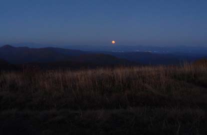 On a perfect clear night with warmish (50s) temperatures and a light wind, 33 hikers climbed to the summit of Black Balsam to enjoy the sunset and moonrise. The beauty of the evening was enhanced by various snacks and beverages carried by hikers. As hikers left in small groups, we could follow their lights below us as they descended the ridge. On a perfect clear night with warmish (50s) temperatures and a light wind, 33 hikers climbed to the summit of Black Balsam to enjoy the sunset and moonrise. The beauty of the evening was enhanced by various snacks and beverages carried by hikers. As hikers left in small groups, we could follow their lights below us as they descended the ridge.
On the way up, we enjoyed the vivid leaf colors along the Parkway, especially through Graveyard Fields. We parked along FS 816 and hiked up the MST and ALT to the summit. After the sun set to the west, a discussion of exactly where the moon would rise ensued. Fifteen minutes later, an orange moon appeared and quickly turned white as it rose into a clear sky. Turning around, we could see bright colors from the fading sun reflections on wispy clouds. As it got darker, the lights of various cities below became clearer, and we could see from north of Asheville to Greenville, SC, and to the west to the illuminated cross on Mt. Lyn Lowery. Venus and Jupiter were very clear and the big dipper appeared closer than usual at this higher elevation. Bruce. Photo by Bruce Bente
WEDNESDAY No. W0804-204 Oct. 22
Max Patch Ramble 8:30 AM
Hike 7.5, Drive 100, 1100 ft., ascent, Rated B-B
Adrian Lotherington, 828-484-9132, jaloth@charter.net
A hike that may be our last opportunity to scale this beautiful section of the AT before Jack Frost descends! We will begin and end at Max Patch, one of WNC’s most stunning views. Second meeting place: Pilot Truck stop at Exit 24 off I-40 at 9:00 AM. Topo: Lemon Gap
No report
All-day hikes submitted by Bruce Bente 692-0116, bbente@bellsouth.net . Driving distance is round-trip from Asheville. All Saturday and Sunday hikes assemble at Westgate Shopping Center near I-240 UNLESS OTHERWISE NOTED.
Half Day hikes submitted by Lucy Prim 828-693-6580 lucette32@mchsi.com.
Wednesday Hikes are submitted by Charlie Ferguson, 828-398-0213 ccf108@gmail.com and Ann Gleason, 828-859-9387,
gleason.ann@gmail.com .
The meeting place for each hike will be designated by the hike leader and will appear in the hike description.
Driving mileage will be listed, round trip, from the first designated meeting place.
Leaders: Mail please mail your sign-up sheets. Meet at Westgate unless otherwise noted. |
