All Day Saturday & Sunday
WEEKEND NO. A1002-tbd Apr. 16-18
Congaree National Park Weekend
Danny Bernstein, 828-236-0192, danny@hikertohiker.com
Spend a weekend hiking, camping and canoeing in Congaree National Park (http://nps.gov/cosw), one of our newest National Parks, near Columbia, SC, a three-hour drive from Asheville (360 miles round trip). This park has the largest remnant of old-growth floodplain forest remaining in North America and its trails are flat. This trip is suitable for everyone. For more information, look at http://www.hikertohiker.com/resources/cmc-congaree-national-park-weekend.
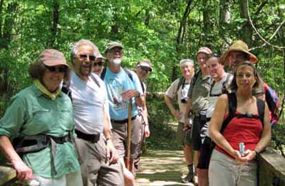 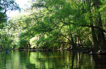
Photos by Danny Bernstein and Sawako Jager
Our group consisted of 25 Carolina Mountain Club members from North and South Carolina; most camped, some stayed in motels.
It seems that everything at Congaree is a scramble. You can't reserve campsites so several of us went down very early on Friday to grab three sites which would hold eight people each. We were lucky and got sites in the After Hours campground, where the parking area was only maybe a hundred feet away. With the other campground, you have to walk in almost a mile. They were primitive sites, with no water and only two outhouses for potentially 64 people.
Friday, we hiked on the boardwalk and down to the Oakridge Trail. Congaree is a floodplain forest and the signature trees are the bald cypress with its characteristic knees - small, rounded pieces of the tree that is thought to stabilize the tree and give air to submerged roots. The hike was flat and we made really good time, almost 2.7 miles an hour, even though we stopped for everything. It was all new to us mountain hikers.
The group had a pot luck dinner on Friday evening at the picnic shelter - another facility we couldn't reserve. We heard from Dr. Bob Janiskee, a retired USC professor who worked on turning Congaree National Monument into a national park.
That evening, the group went on an owl prowl with Ranger Fran, a 29-year veteran who was very entertaining. We didn't see owls but learned about the ecosystem as we toured on the boardwalk.
Saturday, some of us went canoeing while others walked on the River Trail loop. The trail took us down to the Congaree River. On this hike, the wildlife was amazing - snakes including the rough green snake, two barred owls, and even three feral baby hogs. I have hiked in the Smokies for years without ever seeing a hog and here they ran right in front of my eyes.
By Saturday evening, we were ready to go out. Cooking without running water is not fun. Congaree is not close to any town. The closest restaurant was off of I-77, about 30 minutes from the park. We went to Lizard's Thicket, a cheap meat and three vegetable place. For less than seven dollars, we had a good meal.
Sunday, we finally got to go canoeing on Cedar Creek. The park offers canoes and a guided trip to 18 lucky guests - lucky if they win the telephone scramble two weeks before. The park opens up reservations at 8:30 A.M. and 15 minutes later, the spots are gone. But I was able to grab three - Lenny, me and Sawako who sat in the middle. A great place, even if you have to scramble for every facility.--Danny Bernstein
SUNDAY NO. A1002-066 Apr. 25
AT: Garenflo Gap – Bluff Mtn. *8:30 AM
Hike 8.5, Drive 80, 2200 ft. ascent, Rated B-AA
Jim Reel, 828-738-0751, jimr57@yahoo.com & Tish Desjardins 828-656-2191, desraylet@aol.com
We’ll do a loop hike in hardwood forests from Garenflo Gap to the summit of 4686 ft. Bluff Mtn. We will enjoy the many wildflowers that carpet the forest floor while the leader shows off the AT section that he maintains. After lunch on the summit we will do a short bushwhack and then hike parts of the old AT on our way back to the trailhead. *After the hike there will be a potluck supper in the nearby Bear River Community Lodge. Hikers are requested to contribute food for the supper. Food will be taken to a refrigerator before the hike. Please phone Tish Desjardins to coordinate what food to bring. Topo: Lemon Gap
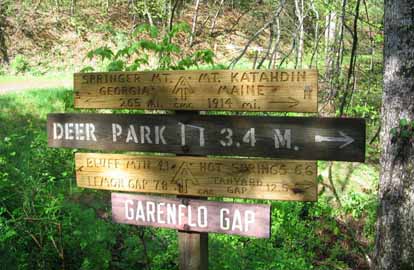 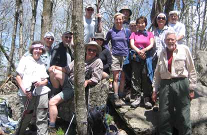
Photos by Jackie Franklin and a thru-hiker
After a night of severe storms, 13 hikers assembled at Garenflo Gap on a beautiful, sunny Sunday morning for a hike on the A.T. Before hitting the trail we checked out new signs replacing a damaged and a stolen sign at the gap. Jackie agreed to keep count as we set out to see how many different wildflowers we could find. We enjoyed Dwarf Crested Iris, Pink Lady Slipper and Showy Orchis as we counted a total of about 45, or so, different blooms. Joanne, Sawako and Catherine were our flower experts for the day.
As we made our way up the trail, we met several thru-hikers, many of which expressed their appreciation of the work of the CMC on the A.T. We also heard some stories about too many hikers in the shelter during Saturday night’s storms.
During our lunch break at the summit of Bluff Mountain, the group shared our carrot cake with a couple of thru hikers that were at the right place at the right time for a little trail magic. After lunch, we continued on southward for a quarter mile, or so, and then bushwhacked down by a spring that is the beginning of West Fork of Shut-In Creek to an old roadbed. Old blazes along parts of the road told of times past when this was the route of the A.T.
After the hike, the hearty hikers enjoyed a delicious potluck dinner as the guests of Ray and Tish Desjardins at the Bear River Community Lodge.
Thanks to the trail crews of the CMC for cutting the large trees from the trail and to Danny Johnson for making and donating the 2 new signs at Garenflo Gap. Thanks to Lisa Hart for supplying the group photo..--Jim Reel
Half Day Sunday
HALF-DAY NO. H1002-431 Apr. 18
Chestnut Cove to MST to Sleepy Gap to Explorer Trail 12:30 PM
Hike 5, Drive 20, 900 ft. ascent, Rated C-C
Nonmembers, call leader, Tom Crook, 828-670-7251, tmc3017@gmail.com
This loop hike begins with a moderately steep climb from the Bent Creek Gap Road to the MST, but is otherwise an easy walk. Second Meeting Place: Ingles parking lot across from Biltmore Square Mall on NC 191 at 12:45 P.M.
The hike began at the Cold Knob parking area on Bent Creek Road from where we traveled a short distance to the upper entrance of the Explorer Loop Trail before heading uphill on the Chestnut Cove Connector to the South Ridge Road. We walked the South Ridge Road, then headed down from it on an unmarked trail that took us to the Pine Tree Trail. From there were returned to the Explorer Trail which took us back to the starting point. The distance was about 4 miles with only a moderate elevation gain/loss. There were nineteen hikers, including 4 or 5 new to the club.--Tom Crook
HALF-DAY NO. H1002-490 Apr. 25
Craven Gap to Folk Art Center *1:00 PM
Hike 5.4, Drive 11, 750 ft. ascent, Rated C-C
Nonmembers, call leader, Bonnie Allen, 828-645-0357, bonnie@allencats.com
*Note that the only meeting place is the back parking lot of the Folk Art Center. A pleasant hike along the Mountains-to-Sea Trail, with a gradual 1640 ft. descent. Car shuttle.
--Back to Top
WEDNESDAY NO. W1002-694 Apr. 14
Mackey Creek Trail *8:00 AM
Hike 8, Drive 75, 1000 ft. ascent, Rated B-B
Joanne Tulip, 828-299-3495, tulipinnc@aol.com and Tommie Boston, 828-686-5029, tambee2@aol.com
*Form carpools at Westgate, and meet leaders at Ingles parking lot off Exit 64 of I-40 at 8:20 AM. From the Curtis Creek Road we descend steeply to Mackey Creek on a rough non-maintained trail. Hiking poles are recommended. Water shoes are also recommended for the several creek crossings. From the creek we ascend steeply on the Connector Trail to Lead Mine Gap. A two mile descent on the Hickory Branch Trail takes us to our cars at Curtis Creek campground. Short car shuttle. Topo: Old Fort
A sunny but cool day greeted 12 hikers to the Mackey Creek Trail located in the Pisgah National Forest near Old Fort. This was the first tract of National Forest land which was purchased in 1911. We descended steeply to the Mackey Creek watershed where we viewed native trout waters and crossed many feeder creeks. Several of the folks enjoyed the cool foot baths on the crossings. We passed many large old hemlocks and oak trees. After lunch by the creek, we ascended a connector trail to Lead Mine Gap. Our descent on the Hickory Branch trail to the Curtis Creek campground produced few wild flowers but displayed lovely waterfalls.--Tommie Boston and Joanne Tulip
WEDNESDAY NO. W1002-401 Apr. 21
Laurel Mountain, Slate Rock *8:30 AM
Hike 8, Drive 70, 1500 ft. ascent, Rated B-B
Greg Goodman , 828-684-9703, greggoodman@bellsouth.net
P400 *Form carpools at Westgate, and meet leader at the North Mills River Parking lot at 9:00 AM. We’ll take Laurel Mountain Ridge Trail to the Slate Rock Creek Trail to the old road and back to our cars. Topo: Dunsmore Mtn.; also NatGeo map #780
Nineteen hardy hikers. Comment from hikers fantastic. A new hike for the data base. Cheers.--Greg Goodman
WEDNESDAY NO. W1002-695 Apr. 28
3 Waterfalls in SC *8:00 AM
Hike 6, Drive 200, 500 ft. ascent, Rated B-C
Jack Fitzgerald, 828-685-2897, suejackfitz@bellsouth.net
WC100 *Form carpools at Westgate, and meet leader at Cracker Barrel, Exit 53 on I-26 at 8:30 AM. We will visit three (and maybe four) waterfalls in South Carolina, all on the Waterfall 100 Challenge: Rileymoore, Brasstown and Opossum. All are in-and-out hikes, 3 miles round trip max. A long drive and long day, but well worth it with waterfalls and spring flowers.
Wednesday, April 28th hike was to four waterfalls in South Carolina; Brasstown, Long Creek, Bull Sluice and Rileymoore, all in and out hikes for a total of about 6 miles. All but Bull Sluice are on the 100 Waterfall Challenge. The weather was perfect. Only 4 CMC members, did the hike.--Jack Fitzgerald
Email your hike reports to Dave Wetmore. The deadline for reports is 9:00 p.m. on the Tuesdays before an eNews comes out. Reports for Wednesday hikes during the eNews publication week will appear in the following eNews--The Editor.
--Back to Top
All-day hikes submitted by Bruce Bente 692-0116, bbente@bellsouth.net . Driving distance is round-trip from Asheville. All Saturday and Sunday hikes assemble at Westgate Shopping Center near I-240 UNLESS OTHERWISE NOTED.
Half Day hikes submitted by Lucy Prim 828-693-6580 lucette32@mchsi.com.
Wednesday Hikes are submitted by Charlie Ferguson, 828-398-0213 ccf108@gmail.com and Ann Gleason, 828-859-9387,
gleason.ann@gmail.com .
The meeting place for each hike will be designated by the hike leader and appears in the hike description.
Driving mileage is round trip, based on the first designated meeting place. Meet at Westgate unless otherwise noted.
|
