All Day Saturday & Sunday
SATURDAY NO. A1003-396 Sept. 25
Pilot Rock – Mt. Pisgah -Thompson Creek *9:30 AM
Hike 9, Drive 80, 1600 ft. ascent, Rated B-A
Stu English, 828-883-2447, stuengo@comporium.net
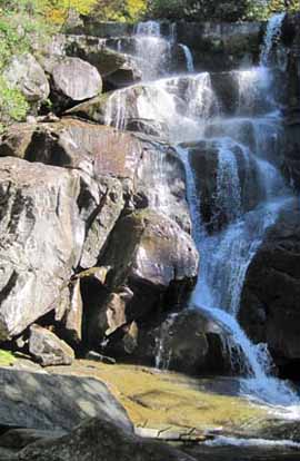
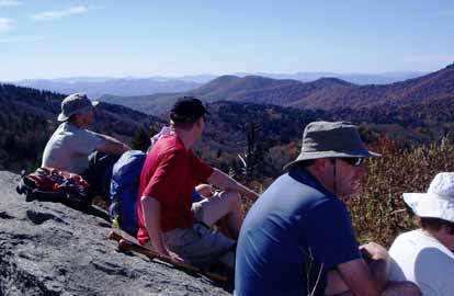
P400 *Form carpools at Westgate, and meet leader at Pisgah Ranger Station at 10:10 AM. We will climb 1500 feet in 2 miles up the well-graded Pilot Rock trail, and eat lunch at Buck Springs Overlook. After lunch, we’ll hike down the Thompson Creek trail. Expect great views along the way. Topos: Dunsmore Mtn., Cruso; also NatGeo map #780
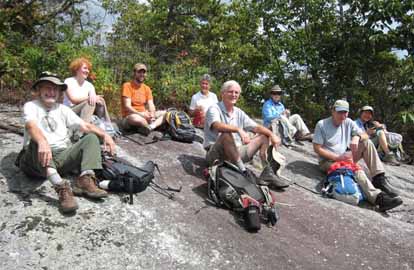
Photo by Jeanie Danner
I led this hike in place of Stuart English. Eleven of us including a few new to CMC hikers started up the Pilot Rock trail and quickly took a wrong turn. After about 500 feet of hiking we realized our mistake and did a 200 foot bushwhack to get back up to the trail. The trail we were on ran alongside Bradley Creek. We were curious as to where it went or how far it went. Once back on the trail we continued up to the Pilot Rock outcrop for a break and the views. We went up the ridge line and straight up to Little Bald. We arrived at Buck Spring hunting lodge to find a memorial service in progress. We continued to the parking area where we ate lunch. We returned via the Laurel Mountain Trail to the junction with Pilot Rock trail again and up to the junction with Thompson Creek Trail. There were a few trees down on that trail but they were easily negotiated. There was a 400 foot descent on this trail which was quite steep with tricky footing due to lots of exposed roots. The rest of the hike was a very pleasant walk through the woods and a road back to our cars. A little rain began to fall as we arrived at the cars. People commented that they felt more tired than the hike description would indicate. After checking the GPS measurements of the hike at home I found that the hike was significantly more difficult that originally advertised. Everyone did well though.--Charlie Ferguson
SUNDAY NO. A1003-701 Sept. 26
Pinnacle – Shortoff Mtns. (Linville Gorge) *8:00 AM
Hike 8.5, Drive 120, 2000 ft.(EB), 2950 ft. (WB) ascent, Rated B-AA
Jacob Cox, 828-584-0395, jcox@mfgnc.com and Jim Reel, 828-738-0751, jimr57@yahoo.com
*Form carpools at Westgate, and meet leaders at Deal Barn (I-40, Exit 90) at 8:45 AM. Great views from east and west promontories at the south end of Linville Gorge. Hike a section of the MST that was ravaged by forest fire several years ago. Carry appropriate footwear for wading Linville River, and poles are recommended due to slippery rocks in river. Key-swap hike. Wilderness area limited to twenty hikers (ten in each direction); contact leaders for reservations. Topo: Ashford; also NatGeo map #779
The hike was cancelled because of the rain.. Jacob had worked hard to plan and set it up. He plans to reschedule as an extra hike if possible.--Jim Reel
SUNDAY NO. A1004-708 Oct. 3
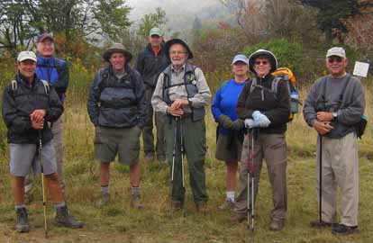
Maddron Bald (Bernard Elias Favorite Hike series #6) *8:30 AM
(strenuous)
Hike 12, 3500 ft. ascent, Drive 150, Rated A-AA+
Ted Snyder, 864-638-3686, tedsnyderjr@bellsouth.net
900M *Form carpools at Westgate, and meet leader at I-40 Tennessee Visitor Center (just past M.P. 447) at 9:30 AM. Spectacular old growth forest, tumbling cascades, fall colors and beguiling vistas add up to a memorable climb of a north wall of the Smokies. Six wet stream crossings. Return via Snake Den Trail. Car shuttle. Topos: Luftee Knob, Mt. Guyot, Jones Cove; also NatGeo map #317
The Asheville contingent reached the Tennessee Visitor Center on I-40 at 9:30. Various weather reports were reviewed. The prognostication was a temperature from 39 F. to 59 F., with rain at 20% to 30% depending on which site was used. Traveled on. The Foothills Parkway is now open after being closed for re-paving. No other construction in progress on it.
Set up shuttle and started hike about 10:30. Thick clouds. Arrived at junction of Albright Grove loop. Group elected to go by Albright Cove. That added 0.5 miles to trip. Rain commenced.
Water was high at the wet crossings we reached after the loop. Rock-hopping was tricky. No one fell in, though there were some wet shoes. Lunched at Back Country camp site 29. In clouds. No views. Rain steady. Thick weeds on trail up to waist high.
Reached Snake Den Ridge Trail junction about 3:00 p.m. Went down it to Cosby Campground. Steady rain. Water bars being dug out mechanically and some logs inserted. Muddy. Arrived at Cosby at 6:00 p.m. Shuttle run, and all left about 6:30 p.m. Seven hikers made the trip.
Weather cold. High 30's. Maybe a high around 40 F.--Ted Snyder
SUNDAY NO. A1004-181 Oct. 3
Black Balsam & Tennent Mtn. to Graveyard Fields *9:00 AM
(moderate)
Hike 7.5, 1100 ft. ascent, Drive 75, Rated B-B
Cindy and Scott McJunkin, 828-213-9701 (cell: 828-712-9646), mcjive@aol.com
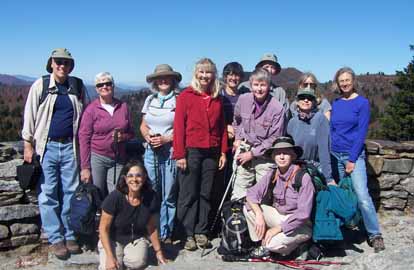
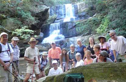
SB6K, P400 *Form carpools at Westgate, and meet leader at BRP Cold Mtn. Overlook at 9:40 AM. This scenic hike traverses a long stretch of balds with spectacular 360 degree views. From FS 816, we’ll hike over 6214 ft. Black Balsam and 6040 ft. Tennent Mtn. to Ivestor Gap, then follow the Graveyard Ridge Trail back to our cars. Car shuttle. Topos: Sam Knob, Shining Rock; also NatGeo. map #780
 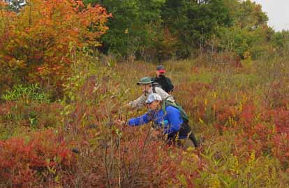
Photos by Cindy McJunkin
Too bad today's hike leaders didn't get the "good weather request" submitted in time; the panoramic views were limited by clouds and fog.
Anticipating clear skies and bright leaves, nine of us gathered on the parkway and shuttled up to Black Balsam. The cloud cover was cool, so we moved quickly along the ridge across Tennet. The sun penetrated briefly a few times, and we saw the beginning of fall cover. The highlight was a few blueberries we found in the Graveyard Fields. Most of us were determined to return later in October to see the colors of fall.--Cindy McJunkin
SUNDAY NO. A1004-033 Oct. 10
Ramsey Cascades (Bernard Elias Favorite Hike series #7) 8:00 AM
(moderate)
Hike 8, 2000 ft. ascent, Drive 160, Rated B-AA
Danny Bernstein, 828-236-0192, danny@hikertohiker.com
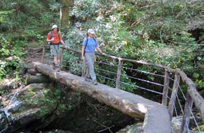
900M This is one of the classic hikes in the Smokies. We will pass through a grove of old-growth tulip poplars on our way to sixty-foot high Ramsey Cascades, located in a rich forested glen. The drive and effort to reach this trail are a small price to pay for the reward. Second meeting place: Pilot Truck Stop at Exit 24 off I-40 at 8:30 AM. Topo: Mt. Guyot; also NatGeo. map #317
Photos by Danny Bernstein
Today was an outstanding fall day - sunny, crisp, the trees full of colors. Seven of us started on Ramsey Cascades Trail in the Greenbrier section of Great Smoky Mountains National Park. One fellow had driven from Atlanta to do this hike.
Holly Demouth, Director of Friends of the Smokies on the North Carolina side, came as a CMC guest. Friends of the Smokies is a fund raising organization that supports the Park. At one break, she talked a little about the work that the Friends did, especially the Trails Forever program. She is so enthusiastic.
The Trails Forever endowment will fund an additional permanent trail maintenance work crew to support trail improvement projects along the 800+ miles of hiking trails inside Great Smoky Mountains National Park. It was particularly apt that we hiked Ramsey Cascade Trail since it had been rehabilitated recently using Trails Forever funds. The volunteer crew had put in rock steps and built a large bridge. Of course, all these improvements have attracted many more visitors on this trail. But that's OK. It's there for everyone to enjoy.
The cascades flowed copoiusly. We reached the top at about one o'clock and had half a lunch there since there were bees circling our food. We enjoyed the trip down whil meeting many hikers going up in the afternoon.--Danny Bernstein
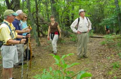
SATURDAY No. A1004-578 Oct. 16
Flat Laurel Creek, Little Sam Knob, MST Loop *10:00 AM
Hike 7.5, 1000 ft. ascent, Drive 80, Rated B-B
Marcia Bromberg, 828-505-0471, mwbromberg@yahoo.com
P400 This is a pleasant loop trail with views of Sam Knob, Fork Ridge and Flat Laurel Creek. We’ll begin on the Flat Laurel Creek Trail, which ascends gradually until we are hiking next to the creek, where we will stop for lunch. Little Sam Knob Trail, with views of Little Sam Knob and Sam Knob, connects to the MST. A one-mile side trip to Devils Courthouse will offer good views before we return on the MST to our cars. Second meeting place: BRP Cold Mtn. Overlook at 10:40 AM.
Photos by Marcia Bromberg
The perfect fall day! The 16 hikers on this hike agreed that the leaves, sky, weather were all perfect. We lunched by Flat Laurel Creek, snacked (and took our group picture) at Devil's Courthouse and enjoyed the fall foliage along the entire hike.--Marcia Bromberg
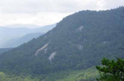
SUNDAY NO. A1004-669 Oct. 17
NC 215 to Buckeye Gap and Fork Ridge 8:00 AM
Hike 10.5, 1500 ft. ascent, Drive 80, Rated A-B
Paul Dickens, 828-476-0010, psdicken@charter.net
P400 We’ll hike the MST up to and out Fork Ridge to beyond Green Knob for great views from overlooks along the way. We’ll see an unnamed waterfall that is said to be the highest waterfall in the eastern US, and then backtrack on Fork Ridge and follow the MST to Buckeye Gap. Wilderness area limited to ten hikers – call leader for reservation. Car shuttle. Second meeting place: BRP Cold Mtn. Overlook at 8:40 AM. Topo: Sam Knob; also NatGeo map #780
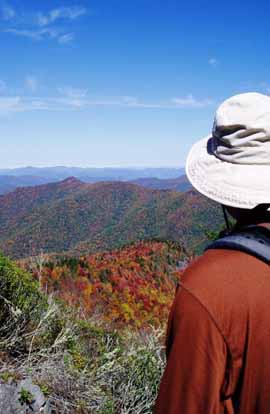 
Photos by Paul Dickens
It was a beautiful clear day up high with 40 to 60 mile views. The fall color below us was at its peak.The hike featured the Green Mountain Trail along Fork Ridge (FS 113), which members of the Saturday CMC Wilderness Crew have reclaimed and are now maintaining from the saddle below Mt Hardy to overlooks about 1/2 mile north beyond Green Knob. The Green Mountain Trail in the Middle Prong is a good alternative to the over-crowded Art Loeb Trail over Black Balsam and into the Shining Rock Wilderness. On the way back from Green Knob, the group took a long break on a grassy bald below the flanks of Mt. Hardy. No one wanted to leave and go home. Everyone agreed it was a great day in the mountains!--Paul Dickens
SUNDAY NO. A1004-165 Oct. 24
Mt. Le Conte via Boulevard, Alum Cave Trails 8:00 AM
Hike 13, 2600 ft. ascent, Drive 150, Rated AA-AA
Lisa Hart, 828-450-6986, tiw.south@gmail.com
SB6K, 900M This classic and exciting hike features great views from the AT, Boulevard Trail, our lunch spot at Cliff Tops on 6593 ft. Mt. Le Conte, and the spectacular Alum Cave Trail. In addition, you can check out the Le Conte Lodge cabins, and see many interesting old photos in the common room of the Lodge. Plan on a long day and an optional stop for supper on the way home. Car shuttle. Second meeting place: Rear of Post Office parking lot in Maggie Valley at 8:30 AM, but call leader first. Topos: Clingman’s Dome, Mt. Le Conte; also NatGeo map #317
--Back to Top
Half Day Sunday
HALF-DAY NO. H1003-437 Aug. 29
Pilot Cove Loop *12:30 PM
Hike 3.5, Drive 80, 1000 ft. ascent, Rated C-B
Nonmembers, call leader, Lee Belknap, 828-698-9394, rivergypsy@sprintmail.com
P400 Form carpools at Westgate, and meet leader at North Mills River Rec. Area parking lot at 1:05 PM. This (shortened version of CMC Hike #437) is a moderate hike up to the top of the cliffs on Fork Ridge, which provides beautiful views of Pilot Cove, Pilot Rock, Pink Beds, and beyond.
Photos by Charlie Ferguson
The hike went well with no significant issues to report. I drove from Flat Rock to Westgate, picked up four hikers who might not have found their way to the second meeting place if I hadn’t shown up there. The rest of the group was ready to go when we arrived and 11 hikers promptly left for the trailhead at the Pilot Cove Loop trailhead. We hiked the loop counterclockwise, snacked at the beautiful outcropping on Forked Ridge, with a great view of Pilot Rock, Pink Beds and more. We finished the hike at a reasonable hour. --Charlie Ferguson
Editors Note: This report was unavoidably delayed.
HALF-DAY NO. H1003-403 Sept. 26
DuPont Forest – Reasonover Trail *12:15 PM
Hike 6, Drive 90, Rated B-C
Nonmembers, call leader, Becky Elston, 828-749-1886, belston@tds.net
*Form carpools at Westgate, and meet leader at Hooker Falls Parking lot in DuPont Forest at 1:00 PM. This pleasant loop hike in DuPont Forest includes the Fawn Lake, Corn Mills Shoals, Bridal Veil Falls, Lake Julian and Reasonover Creek Trails, and features views of small waterfalls.
We needed the rain so badly I didn't mind cancelling Sunday afternnon hike on Reasonover trail in Dupont. No one showed.--Becky Elston
HALF-DAY NO. H1004-381 Oct. 3
Snowball Trail *12:30 PM
Hike 5.5, Drive 30, 1000 ft. ascent, Rated C-B
Nonmembers, call leader, Bobbi Powers, 828-667-5419, bobbipowers@live.com
*Only meeting place: back parking lot of Folk Art Center at 12:30 PM. This in-and-out hike has a steady climb (some hikers consider it to be steep) to High Rocks (Hawkbill Mtn.). Diverse and centennial trees to be admired all the way on the ridge. Stop for a snack at Snowball Mountain before return.
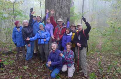
Photo by Bobbi Powers
Thirteen hikers trekked Snowball Trail over Hawkbill Rock and on to the turn-around point at a magnificent 16-feet circumference oak tree. Yes, we measured the tree with a tape measure. This hike, while less than 5 miles, was a strenuous workout with many ups and downs. A temperature of 42 degrees + wind + mist + being in a cloud made us think of snow, and the only views from Hawkbill Rock were white, white, and more white; the trail’s name was very appropriate on this day! One good thing about the cold day – a huge nest of unavoidable yellow jackets was not very active. We all agreed that hiking in a cloud was an interesting, mysterious experience, and we all looked forward to hot showers.--Bobbi Powers
HALF-DAY NO. H1004-706 Oct. 10
Big Bradley and Little Bradley Falls *12:30 PM
Hike 3.5, Drive 60, 300 ft ascent, Rated C-C
Nonmembers, call leader, Sawako Jager, 828-687-2547 (cell: 674-4067), baiko70@aol.com
WC100 *Meet at 12:30 PM at Westgate to form carpools, and meet leader at Cracker Barrel parking lot (near road), I-26 Exit 53 at 1:00 PM. An easy hike to two of the WC100 falls. Big Bradley is a nice 75 foot falls. Little Bradley is a 35 foot 3 level falls. This trip to Big Bradley will not include going down to the base of the falls which is dangerous. We will hike downstream along Cove Creek to an overlook, see Big Bradley and hike back to the trailhead. We’ll then cross the road and walk up the road aways and down to the creek again, walking upstream about 3/4 mile to Little Bradley Falls and then back to the trailhead.
Photos by Sawako Jager
Today was a spectacular fall day. Twenty of us met and drove to the Big Bradley Falls trailhead only to find about 15 vehicles already parked there!
Everybody bravely waded Cove Creek and saw the 80 ft high Big Bradley Falls. I wish a safe observation deck would be built someday. It sure would be very nice. We walked back to the parking area and across the road to the Little Bradley Falls trailhead. We hiked through the peaceful woods and waded Cove Creek again to reach the beautiful Little Bradley Falls where we we enjoyed a snack. It couldn't have been a better day weatherwise and the group was a lot of fun to be with.--Sawako Jager
HALF-DAY NO. H1004-034 Oct. 17
NC 215 to FS 816 *12:00 PM
Hike 5.5 miles, Drive 85, 900 ft. ascent, Rated C-B
Nonmembers, call leader, Jane Laping, 828-277-7342 (cell: 828-772-0379), janelaping@sbcglobal.net
P400 *Form carpools at Westgate, and meet leader at Cold Mountain Overlook on the Blue Ridge Parkway at 12:40 PM. This hike will introduce many hikers to a choice section of the MST, including Devils Courthouse. Car Shuttle.
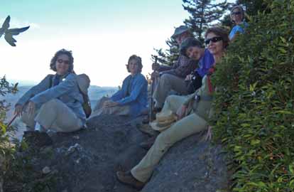
Photo by Jane Laping
Although we had missed the peak of fall color, there was still plenty of color to see on this hike through hardwoods and fir forests. We stopped several times for views of the surrounding area including Devil’s Courthouse, but the best was when we climbed a huge boulder for a 360 degree view. We could easily identify Sam’s Knob, Little Sam’s Knob, and Pilot Mountain nearby. Fourteen hikers made the 5.5 mile mostly uphill trek on a clear and warm fall day. It was a great hike for recognizing Mountain-to-Sea Trail month.--Jane Laping
HALF-DAY NO. H1004-319 Oct. 24
Holmes State Forest *12:30 PM
Hike 5.2, Drive 75, 500 ft ascent, Rated C-C
Nonmembers, call leader, Ashok Kudva, 828-698-7119 (cell: 828-674-1374), ashok.kudva@gmail.com
*Form carpools at Westgate and meet leader at Bi-Lo in Pisgah Forest at 1:00 PM. Pleasant walk through Holmes State Forest The first 0.7 miles on Wildcat Rock Trail has a steep 450 ft climb. It is a well maintained trail with smooth switchbacks.
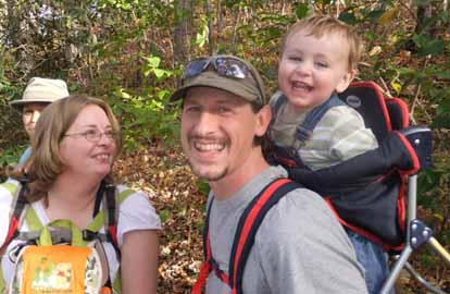 
Photos by Ashok Kudva and Danny Bernstein
On this beautiful fall day 29 hikers assembled for this hike, offered by CMC only twice before, in one of the 6 North Carolina educational forests. The weather was spectacular and many leaves had fallen to the ground but the few still on the trees were colorful. My GPS tracked the hike at 4.7 miles with 850 feet ascent/descent. The first 0.6 miles on well maintained Wildcat Rock Trail was a steep 470 ft climb. A couple of hikers struggled in this 15% grade segment and a sore back bothered another for a short time until the Advil kicked in. These issues caused us to spread out and offered challenges to the leader. Everyone finished the hike safely. Marcia, Lenny and Bobby shared the sweep duties and provided strong support . Ten hikers participated as traffic cops to staff every trail intersection to prevent losing any hiker in the long hiking caravan. The highlight of the day was 19 month old Cameron Cox riding in his dad’s backpack! His parents Jacob and Veronica certainly are encouraging CMC to be a family hiking club. Cameron enjoyed pushing the button on talking trees to get an immediate reward of audio descriptions of the forest trees in the Talking Tree Trail. But most hikers who are grandparents enjoyed triggering the voice recorded tree description as much as the sweet toddler!--Ashok Kudva
--Back to Top
All Day Wednesday
WEDNESDAY NO. W1003-193 Sept. 22
MST: Bearpen Gap to NC 215 via Mt. Hardy 8:00 AM
Hike 9.1, Drive 90, 1700 ft. ascent, Rated A-A
Barbara Morgan, 828-738-3395, bcmorg@hughes.net
SB6K, P400 This MST hike leads through a beautiful forest of spruce, birch, rhododendron and maple, with mosses and ferns lining the forest floor. A special feature is a short side trip up 6110 ft. Mt. Hardy, with first-rate views on its north side. Partly through the Middle Prong Wilderness area, limit 10, so call leader for reservation. Car shuttle Second meeting place: Rough Butt Bald overlook at 9:00 AM. Topo: Sam Knob; also NatGeo map #780 and USFS Shining Rock Wilderness map
Photos by Ted Connors
This hike, through varied and beautiful terrain went well for the most part. The 10.1 mile hike is pleasant in not being very steep and having more descent than ascent. We enjoyed lunch beside Buckeye Creek and most did the optional hike up Mt. Hardy and Rich Sampson "bagged" the peak for his SB6K challenge. We found one yellowjacket nest (one victim, one sting). The nest is well marked on the NC 215 side of the MST and at about mile 45.5 in Walt Weber's MST Trail Profiles and Maps, p. 33. The nest is on the wall of a shallow, foot-wide ditch about 20 feet from a large hemlock on the Parkway side.--Barbara Morgan
WEDNESDAY Relaxed MST hike - Sept. 22
French Broad Overlook to Sweeten Creek Road 25A 10:30 AM
HIke 6.4 miles, not much elevation gain, Rated B-C
Barth Brooker, 828-299-0298, barthb@bellsouth.net
An easy start to hiking the MST. Meeting Place - Folk Art Center.
Call Barth if you want to meet at the French Broad Overlook MP 394.
This hike was from French Broad to 25A. We had 6 people on this hike--Barth Brooker
WEDNESDAY NO. W1003-051 Sept. 29
White Oak Flats, Pounding Mill, Hickey Fork *9:00 AM
Hike 8, Drive 85, 1900 ft. ascent, Rated B-A
Tish Desjardins, 828-656-2191, desraylet@aol.com
*Form carpools at Westgate, and meet leader at US25/NC208 intersection at 9:45 AM. Since the Forest Service has built a splendid new footbridge over Hickey Fork, CMC is now able to schedule this hike which we have not done in 10 years. A nice loop hike using three different trails and finishing on the newly and heavily rebuilt Hickey Fork Rd. Second meeting place: Meet leader at US25/NC208 intersection at 9:45 AM. Topos: White Rock, Greystone; also NatGeo map #782
A huge improvement on the the trails thanks to the trail crews' extremely hard work. It used to look like a war zone. Also, the Forest Service completely re-built the gravel road with drain pipes to prevent erosion. Sixteen of us enjoyed the wild beauty of these woods and the lovely cascade of falls on Hickey Fork. This was the first time in ten years that a CMC hike was done here in the Shelton Laurel area of Pisgah National Forest.
A few things remain to be finished whenever a trail crew can get back over there: removal of a huge root ball on Hickey Fork trail a few minutes past the waterfall; about six blowdowns of small diameter need to be sawed on the White Oak Flats trail.--Tish Desjardins
WEDNESDAY Relaxed MST hike - Sept. 29
Sweeten Creek Road 25A to the BRP Destination Center including the
loop trail 10:30 AM
HIke 6.7 miles, about 300-400 feet elevation gain, Rated B-C
Barth Brooker, 828-299-0298, barthb@bellsouth.net
Meeting Place - Folk Art Center.
On this hike we had 15 people. The people on the hikes were good hikers and appreciated the shorter duration and slower pace.--Barth rooker
WEDNESDAY NO. W1004-469 Oct. 6
Craggy Gardens Visitor Center to Bull Gap Road *8:30 AM
Hike 8.7, 1650 ft. ascent, Drive 45, Rated B-A
Jim Ariail, 828-505-0443,cell: 828-778-8355, jimariail@yahoo.com
*Only meeting place: the lower parking lot of the Folk Art Center. This hike starts at the Craggy Gardens Visitor Center featuring great views on the MST to Lane Pinnacle and the historic Rattlesnake Lodge site. Topo: Montreat
WEDNESDAY NO. W1004-713 Oct. 13
Bent Creek Experimental Forest 8:30 AM
Hike 6, 800 ft. ascent, Drive 20, Rated B-C
Lenny Bernstein, 828-236-0192, lsberns@att.net
Ever wonder what kind of research they do at Bent Creek? This is your chance to find out. We’ll start with a one-to-two hour outdoor tour led by a member of the Forest Service staff, and then take a short hike from the Hard Times Trailhead.
Photo by Danny Bernstein
Originally this hike was advertised as a chance to find out about the Forest Service’s research at Bent Creek. However, due to the visit of a high level Forest Service manager on Oct. 13, our tour guide had to cancel out. Instead we scheduled a 10 mile loop hike through Bent Creek. I had thought it was a variation of Hike 554 in the CMC Hike Data Base, but it was actually Hike 589, the MST from NC 191 to Sleep Gap, then the Sleepy Gap, Explorer Loop and Pine Tree Loop Trails to Lake Powhatan, and back to NC 191 on Bent Creek Road.
Six participants showed up and despite it being a harder hike than they were promised, and a not too promising weather forecast. We had a great hike with sunny skies and beautiful Fall colors.--Lenny Bernstein
WEDNESDAY NO. W1004-267 Oct. 13
Horsepasture River 8:00 AM
Hike 7, 1500 ft. ascent, Drive 105, Rated B-B
Jack Fitzgerald, 828-685-2897, suejackfitz@bellsouth.net
WC100 *Form carpools at Westgate, and meet the leader at Pisgah Bi-Lo at 8:35 AM. Hike to four waterfalls on the Horsepasture River: Stairway, Rainbow, Turtleback, and Drift. This is as good as it gets, all top rated waterfalls and all entirely different. Relatively new access thru Gorges State Park. Topo: Reid
Twelve hikers showed up for the hike to the waterfalls on Horsepasture River. We broke into two groups, with 5 going down to Windy Falls, and the other 7 taking the advertised hike to Rainbow, Turtleback, Drift and Stairway Falls. The weather was perfect. Had lunch at the base of Rainbow Falls. We were all back to the cars by 2:00 PM.--Jack Fitzgerald
WEDNESDAY NO. W1004-584 Oct 20
Butter Gap Loop 8:30 AM
Hike 9, 2000 ft. ascent, Drive 75, Rated B-A
Stan Endich, 215-290-8299, sjemiata@gmail.com
P400 The hike leaves from the fish hatchery via Cat Gap loop to the Art Loeb Trail to the Butter Gap Shelter and returns via Butter Gap trail back to the Pisgah Fish Hatchery. Second meeting place: Fish Hatchery at 9:10 AM. Topos: Rosman, Shining Rock; also NatGeo map #780
It was raining as I drove to Westgate Mall. I had decided to cancel the hike to avoid a soggy start and a rainy hike. Two eager hikers arrived just about 8:30 AM when I was about to leave for the second meeting place. The rain had almost stopped, but the forecast was still predicting rain until noon. We drove to the Fish Hatchery only to find another six more eager hikers. Since the rain had stopped I decided to proceed with the hike.
We crossed a bridge next to the Fish Hatchery and turned west onto the Cat Gap Loop trail. This trail is well groomed with a moderate slope. We proceeded onto the Butter Gap Trail, which has a steeper slope. This trail parallels Grogan Creek where three waterfalls were evident. We arrived at Low Gap, a junction with five interconnecting trails that connect to the Art Loeb Trail. After passing a shelter on the Art Loeb Trail we proceeded across a creek and started to climb. We climbed further and reached a campsite near the east rocky incline of Cedar Rock Mountain, where we ate lunch. After leaving the campsite the trail is level for a while and then climbs to the junction of Cat Gap Loop. We proceeded north on the Cat Gap Loop Trail, which descends past the trail to John Rock then crosses a log bridge and proceeds along a stream and winds back to the Fish Hatchery along the Davidson River.
The weather cooperated (no rain) and was sunny by the time we returned to the cars. I received many comments as we hiked that this was the best “non-hike” anyone had ever been on.--Stan Endich
WEDNESDAY NO. W1004-250 Oct 27
Douglas Falls-Locust Ridge Circuit 8:00 AM
Hike 9, 2200 ft. ascent, Drive 60, Rated A-A
Mary Beth Gwynn, 828-545-6487, mbgcmc@gmail.com
SB6K Take trail to Douglas Falls, then continue through hemlock forest to MST. Left on MST to Greybeard Overlook on BRP (good lunch stop with great view). A 1 mile round trip side hike to Craggy Dome can be done during lunch stop. Go north on MST through blueberry fields to Locust Ridge, then bushwhack down ridge to car. Topos: Montreat and Craggy Pinnacle
Email your hike reports to Dave Wetmore. The deadline for reports is 9:00 p.m. on the Tuesdays before an eNews comes out. Reports for Wednesday hikes during the eNews publication week will appear in the following eNews--The Editor.
--Back to Top
All-day hikes submitted by Bruce Bente 692-0116, bbente@bellsouth.net . Driving distance is round-trip from Asheville. All Saturday and Sunday hikes assemble at Westgate Shopping Center near I-240 UNLESS OTHERWISE NOTED.
Half Day hikes submitted by Lucy Prim 828-693-6580 lucette32@mchsi.com.
Wednesday Hikes are submitted by Charlie Ferguson, 828-398-0213 ccf108@gmail.com and Ann Gleason, 828-859-9387,
gleason.ann@gmail.com .
The meeting place for each hike will be designated by the hike leader and appears in the hike description.
Driving mileage is round trip, based on the first designated meeting place. Meet at Westgate unless otherwise noted. |
